
TC Watch / 熱帶氣旋 > Selected TC Review / 重要熱帶氣旋回顧 > 202208W [Refresh 更新]
 202208W - Profile 檔案 202208W - Profile 檔案 |
(First draft issued on August 18, 2022, final version issued on September 18, 2022)
(初稿於 2022 年 8 月 18 日發出,最後版本於 2022 年 9 月 18 日上載)
Brief profile of 08W | 08W 小檔案:
| JTWC number 聯合颱風警報中心 (JTWC) 號碼 | 08W |
| International number 國際編號 | ---- |
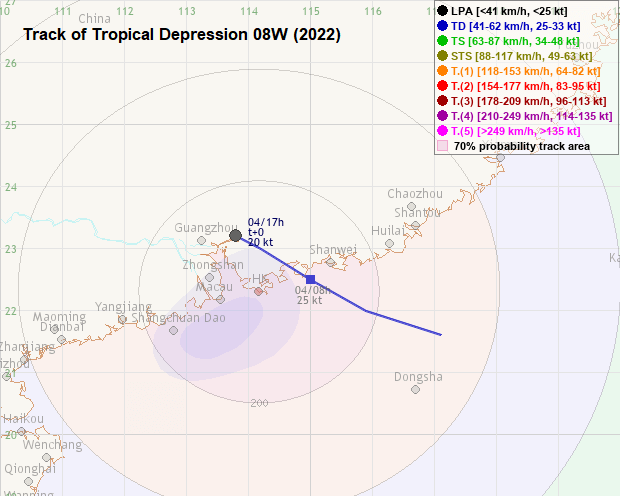
| Period of existence 生存時期^ | 2022/08/03 20 HKT - 2022/08/04 11 HKT |
| Estimated maximum 1-minute wind 估計一分鐘平均最高中心風速& | 25 knots 節 (Tropical Depression 熱帶低氣壓) |
| Highest TC signal by HKO 香港天文台發出最高熱帶氣旋警告信號 |
1 (Standby Signal 戒備信號) |
| Closest point of approach by HKO 香港天文台所示之最接近距離 |
NNE 90 km (real-time warning 實時報告) / NE 80 km (TC report 熱帶氣旋報告) |
| Time of closest approach by HKO 香港天文台所示之最接近時間 |
2022/08/04 14 HKT (real-time warning 實時報告) / 11 HKT (TC report 熱帶氣旋報告) |
| Lowest pressure recorded at HKO 香港天文台錄得的最低氣壓 |
1003.6 hPa 百帕 (2022/08/04 04:15 HKT) |
^Refers to the period between the HK Observatory's first and last bulletins for the tropical cyclone (with at least tropical depression intensity). For storms formed/dissipated/transformed into an extratropical cyclone outside the area bounded by 7-36°N and 100-140°E, information from the JTWC will be used instead.
^即香港天文台為該熱帶氣旋 (熱帶低氣壓級或更高) 作出發佈的時期。至於在北緯 7 至 36 度、東經 100 至 140 度外形成/消散/轉化為溫帶氣旋的風暴,本網將參考聯合颱風警報中心的資料。
&Based on HKWW track information.
&基於本站路徑資料。
TC signals in Hong Kong* 香港曾經生效的熱帶氣旋警告*:
| Signal 信號 |
Date and time 日期和時間 |
Distance from HK 與香港的距離 |
Predicted movement 預測移動趨勢 |
Max. 10-min winds 中心最高十分鐘平均風速 |
 |
2022/08/03 (WED) 22:10 HKT | ESE 250 km | WNW at 15 km/h | 45 km/h (25 knots, TD) |
 |
2022/08/04 (THU) 14:40 HKT | NNE 90 km | WNW at 15 km/h | 40 km/h (20 knots, LPA) |
*Based on the information from real-time tropical cyclone warning bulletins.
*根據實時熱帶氣旋警報資料。
IR imagery animation 紅外線雲圖動畫:
TC track from HKWW 本站的熱帶氣旋路徑圖:
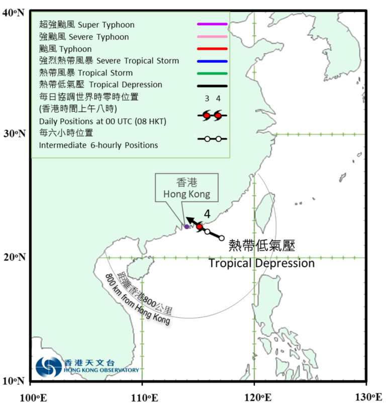
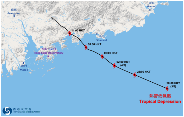
TC track from HKO 天文台的熱帶氣旋路徑圖:
| Past HKWW Bulletins 本站發佈 |
Please click here for bulletins on this tropical cyclone. 請按這裡。
| Storm Development Overview 風暴發展概覽 |
Unless otherwise stated, all times below are in Hong Kong Standard Time (UTC+8)
除非特別註明,下文時間均為香港標準時間 (協調世界時加 8 小時)
A trough of low pressure brought unstable weather to northeastern South China Sea in early August. On August 3, a circulation developed within the trough and its cloudbands expanded. The JTWC issued a tropical cyclone formation alert for that disturbance, labelled as 96W, in the afternoon. The NMC upgraded it into a tropical depression at 5 pm the same day and predicted that the cyclone would move west-northwest towards coastal Guangdong.
Due to its proximity to land, 96W's convections concentrated in its southern semicircle. The storm moved west-northwest during the night of August 3 but took a more northerly track in the small hours of August 4. That morning, the JTWC upgraded the system into a tropical depression, giving it the storm number 08W. According to the NMC, 08W made landfall near Huidong County, Guangdong at around 9:40 am.
Upon landfall, 08W's convections dissipated gradually. It weakened into an area of low pressure near Huizhou that afternoon.
8 月初,一道低壓槽為南海東北部帶來不穩定天氣。8 月 3 日,該低壓槽中有一環流形成,雲帶有所擴闊。聯合颱風警報中心於下午為該擾動 (96W) 發出熱帶氣旋形成警報。中國中央氣象台於同日下午 5 時將其升格為熱帶低氣壓,預料該氣旋將向西北偏西移動,趨向廣東沿岸。
由於 96W 接近陸地,其對流集中於南半圓。風暴於 8 月 3 日晚向西北偏西移動,但於 4 日凌晨採取較為偏北的路徑。當天早上,聯合颱風警報中心將該系統升格為熱帶低氣壓,並給予風暴編號 08W。根據中央氣象台發佈,08W 於上午約 9 時 40 分登陸廣東省惠東縣一帶。
登陸後,08W 的對流逐漸消散,當天下午於惠州一帶減弱為低壓區。
| Weather in Hong Kong During Approach 風暴影響時香港天氣狀況 |
Link to relevant HKO weather report bulletins:
3/8 ●
4/8
香港天文台相關天氣報告連結:3/8 ●
4/8
Before 08W's formation, it was rainy in Hong Kong on August 3. The Amber Rainstorm Warning was in force between 3:30 pm and 5 pm. More than 70 mm of rain was recorded in eastern Kowloon and eastern New Territories. The Observatory upgraded the system into a tropical depression in its weather report at 9:45 pm, and issued the #1 Standby Signal at 10:10 pm when 08W was about 250 km east-southeast of Hong Kong. It originally predicted 08W to make landfall east of Hong Kong, but the forecast track was changed near midnight August 4 in favour of a close approach to the south of Hong Kong.
As 08W made landfall and moved closer to Hong Kong on August 4, local winds turned westerly in the morning. However, winds remained light to moderate in most places. 08W's impact was short-lived, as southerly winds set in soon after its passage. The storm remained at around 80 to 90 km from the Observatory that morning and in the early afternoon. As 08W's structure deteriorated, the HKO downgraded it into an area of low pressure and cancelled the #1 Signal at 2:40 pm. 08W's rainbands mostly affected Hong Kong in the morning and in the late afternoon; part of northern New Territories and Lantau received more than 50 mm of rain that day.
08W's remnants drew an active southerly airstream, which continued to bring heavy showers to the territory on August 5. The Amber Rainstorm Warning was issued twice that day. The daily rainfall at the Observatory was 165.5 mm, while most of Hong Kong Island received more than 150 mm of rain.
08W 形成前,8 月 3 日香港有雨,黃色暴雨警告信號曾於下午 3 時 30 分至 5 時間生效,東九龍及新界東部全日錄得超過 70 毫米雨量。天文台於下午 9 時 45 分的天氣報告中將該系統升格為熱帶低氣壓,並於下午 10 時 10 分發出一號戒備信號,當時 08W 位於香港東南偏東約 250 公里。原先的預測路徑顯示 08W 將於香港以東登陸,但天文台於午夜左右更改預測,預計 08W 於香港以南近距離掠過。
隨著 08W 於 8 月 4 日登陸並移近香港,本地轉吹偏西風,但大部分地區風勢仍然維持輕微至和緩水平。08W 影響香港時間短暫,風暴掠過後不久便轉吹南風。08W 於 4 日早上至下午初段與天文台維持約 80 至 90 公里距離。下午 08W 的結構轉差,天文台於 2 時 40 分將其降格為低壓區,並取消一號信號。08W 的雨帶主要於早上及下午後段影響香港,當日新界北部及大嶼山部分地區錄得超過 50 毫米雨量。
08W 的殘餘引進一道活躍偏南氣流,於 8 月 5 日繼續為本港帶來大驟雨,黃色暴雨警告信號於當天兩度發出。天文台當天雨量達 165.5 毫米,而港島大部分地區雨量超過 150 毫米。
| Image Gallery 圖片庫 |
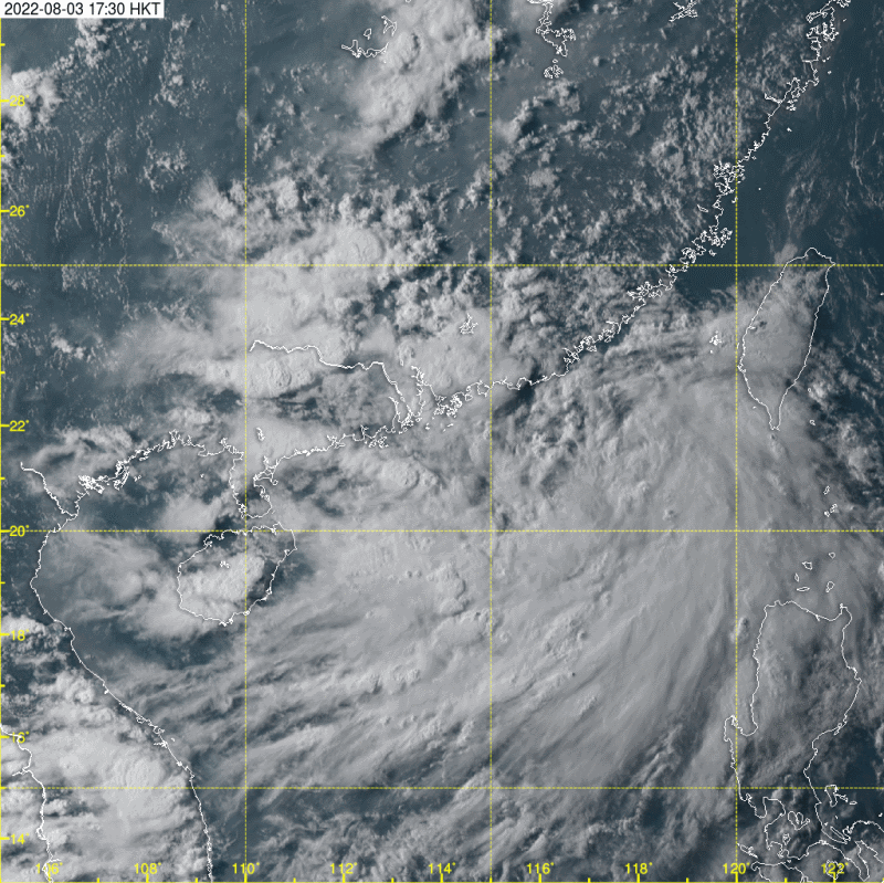
Figure 1 - Satellite image of 08W prior to its formation in northeastern South China Sea
圖 1 - 08W 於南海東北部形成前之衛星雲圖
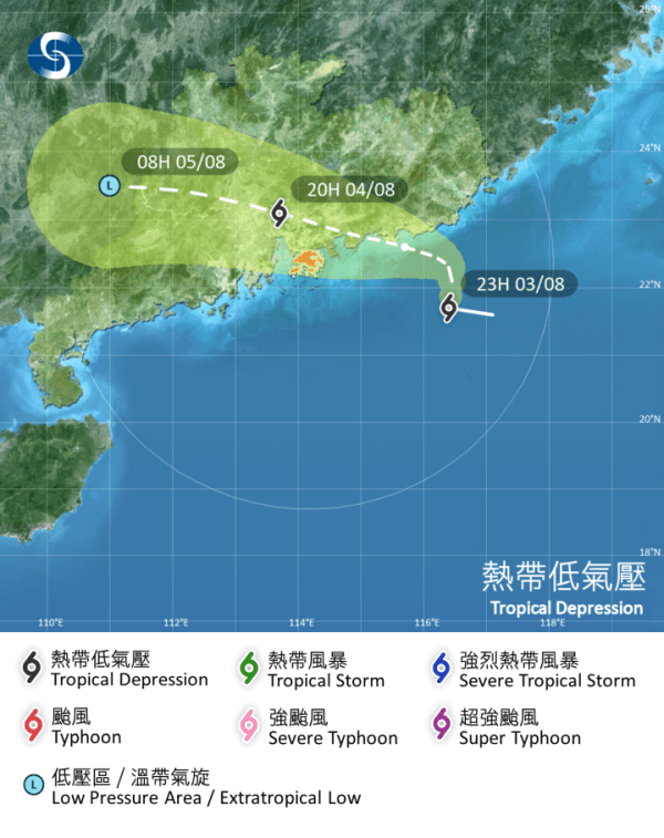
Figure 2 - HKO's forecast track at 11 pm August 3 (left) and midnight August 4 (right)
圖 2 - 8 月 3 日下午 11 時 (左) 及 4 日午夜 (右) 香港天文台之預測路徑圖
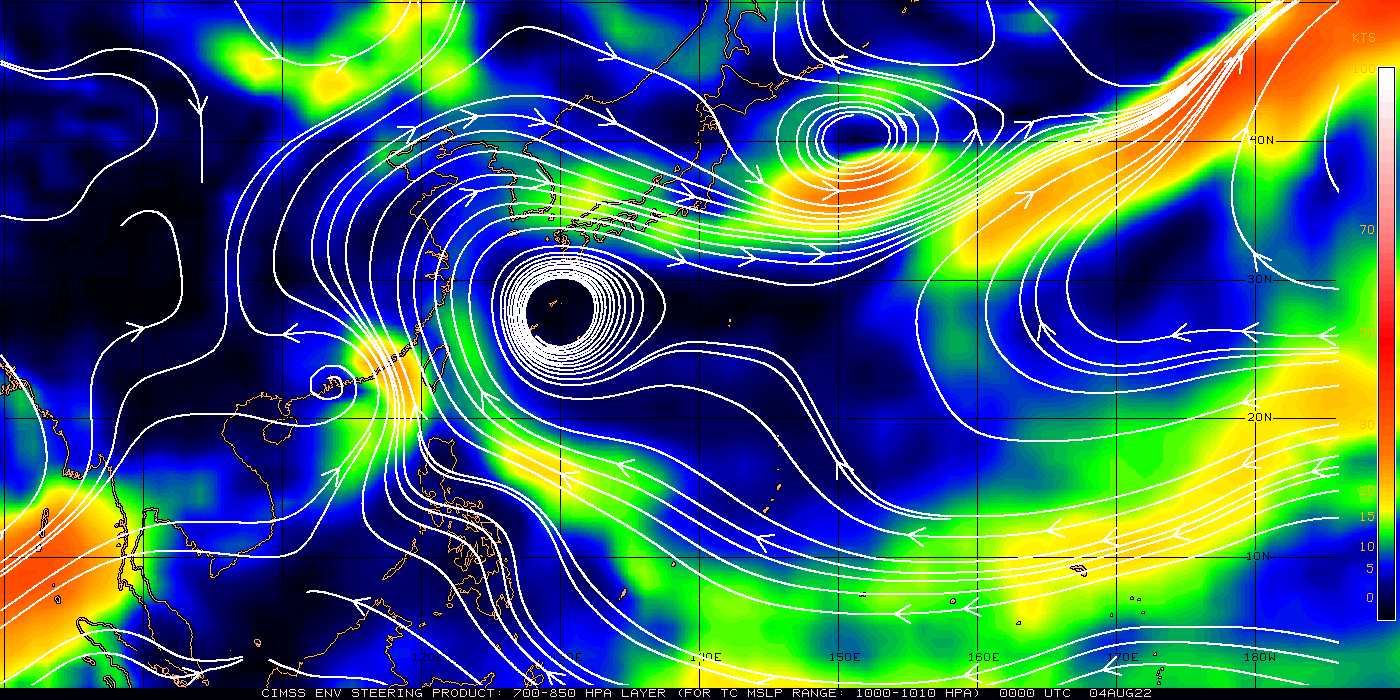
Figure 3 - Steering flow chart at 8 am August 4
圖 3 - 8 月 4 日上午 8 時之駛流場分佈圖
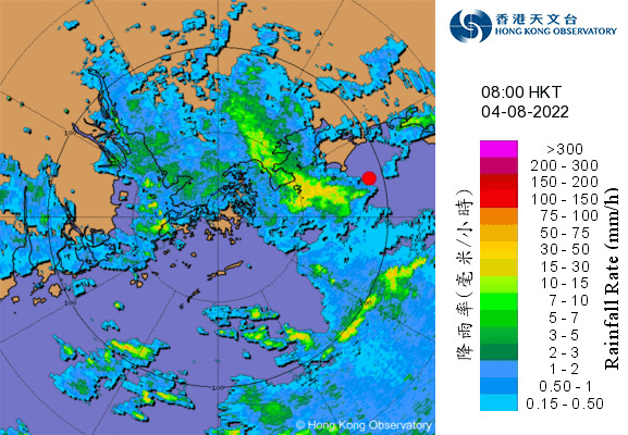
Figure 4 - Radar image at 8 am August 4. 08W's estimated location is indicated in red.
圖 4 - 8 月 4 日上午 8 時之雷達圖。08W 的估計位置以紅色標示。
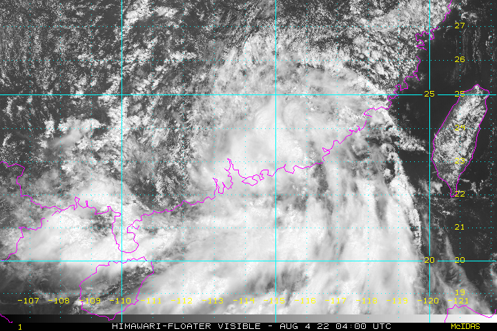
Figure 5 - Satellite image of 08W at noon August 4
圖 5 - 08W 於 8 月 4 日正午之衛星雲圖

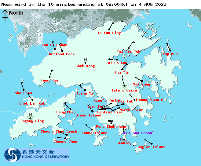
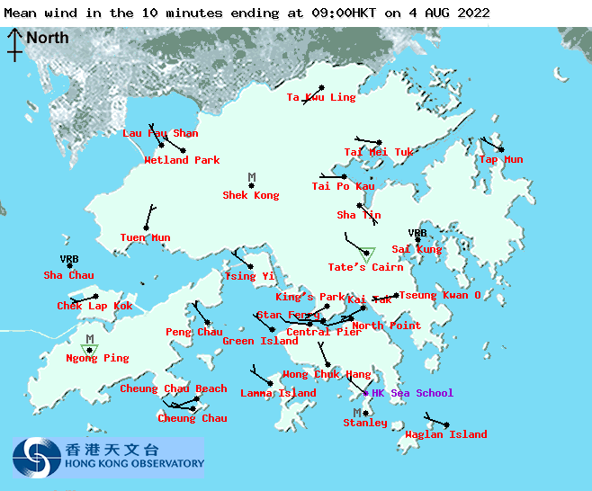

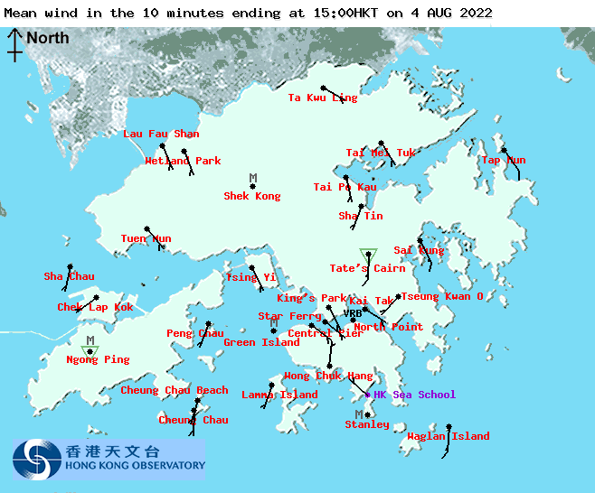
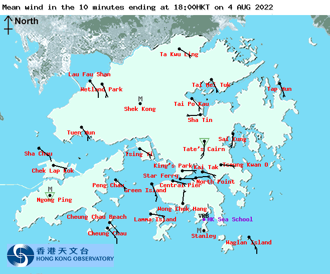
Figure 6 - Local wind distribution maps at 3-hour intervals from 3 am to 6 pm August 4
圖 6 - 8 月 4 日上午 3 時至下午 6 時每 3 小時之本港風勢分布圖
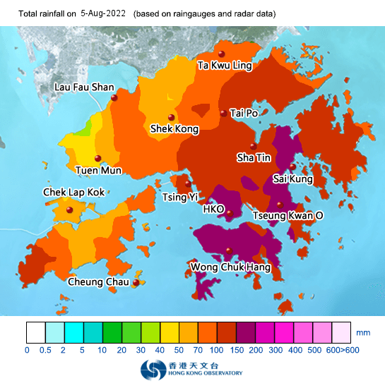
Figure 7 - Rainfall distribution map for August 5
圖 7 - 8 月 5 日之雨量分佈圖
| Winds Recorded at Reference Stations 參考站所錄得的風速 |
The following table lists the maximum 10-minute average (sustained) wind speed recorded while tropical cyclone signals were in force. In some occasions, it is possible that the strongest winds were not recorded when the highest signal was in force.
下表列出各站於熱帶氣旋警告信號生效時所錄得的最高 10 分鐘平均 (持續) 風速,留意此風速不一定於最高信號生效期間錄得。
| Station 風速站 |
Max. 10-min avg. wind speed 最高十分鐘平均風速 |
Beaufort classification 蒲福氏風級分類 |
| Chek Lap Kok 赤鱲角 | The maximum sustained wind speed for all reference stations are below the "fresh" threshold of 31 km/h 所有參考站最高持續風速均低於「清勁」下限的每小時 31 公里 |
|
| Cheung Chau 長洲 | ||
| Kai Tak 啟德 | ||
| Lau Fau Shan 流浮山 | ||
| Sai Kung 西貢 | ||
| Sha Tin 沙田 | ||
| Ta Kwu Ling 打鼓嶺 | ||
| Tsing Yi (SHL) 青衣蜆殼油庫 | ||
| Number of stations recording at least STRONG force (force 6 - 7) winds: | 0 |
| Number of stations recording at least GALE force (force 8 - 9) winds: | 0 |
| Number of stations recording at least STORM force (force 10 - 11) winds: | 0 |
| Number of stations recording HURRICANE force (force 12) winds: | 0 |
| 錄得 強風 (6 - 7 級) 或更高風速的站數: | 0 |
| 錄得 烈風 (8 - 9 級) 或更高風速的站數: | 0 |
| 錄得 暴風 (10 - 11 級) 或更高風速的站數: | 0 |
| 錄得 颶風 (12 級) 風速的站數: | 0 |
| Charts and Figures 各項數據 |
Table 1: Track data from HKWW:
表一 : 香港天氣觀測站之路徑資料
YYMMDDZZ Lat Long Wind |
Table 2: Maximum gust and hourly average wind speed recorded in Hong Kong from HKO:
表二 : 香港天文台公佈的各站最高每小時平均風力和陣風數據 (英文)
Maximum Gust |
Maximum Hourly Mean Wind |
|||||||
|---|---|---|---|---|---|---|---|---|
| Direction |
Speed (km/h) |
Date/Month |
Time |
Direction |
Speed (km/h) |
Date/Month |
Time |
|
| Central Pier | WNW | 27 | 4/8 | 09:30 | W | 19 | 4/8 | 10:00 |
| Cheung Chau | W | 32 | 4/8 | 08:57 | W | 19 | 4/8 | 09:00 |
| Cheung Chau Beach | W | 26 | 4/8 | 08:38 | W | 11 | 4/8 | 09:00 |
| Green Island | NNW | 33 | 4/8 | 06:23 | ENE | 23 | 4/8 | 00:00 |
| Hong Kong International Airport | WNW | 37 | 4/8 | 08:38 | W | 18 | 4/8 | 09:00 |
| Kai Tak | ESE | 21 | 4/8 | 14:34 | W | 9 | 4/8 | 10:00 |
| King's Park | W | 25 | 4/8 | 09:39 | W | 10 | 4/8 | 10:00 |
| Lamma Island | NW | 32 | 4/8 | 09:36 | NW | 22 | 4/8 | 10:00 |
| Lau Fau Shan | N | 31 | 4/8 | 07:27 | N | 15 | 4/8 | 08:00 |
| North Point | WSW | 26 | 4/8 | 09:37 | W | 18 | 4/8 | 10:00 |
| WSW | 26 | 4/8 | 09:39 | |||||
| Peng Chau | WNW | 30 | 4/8 | 09:08 | NW | 16 | 4/8 | 10:00 |
| Ping Chau | W | 25 | 4/8 | 10:06 | WSW | 12 | 4/8 | 11:00 |
| Sai Kung | SSE | 27 | 4/8 | 14:38 | SSE | 9 | 4/8 | 14:00 |
| SSE | 27 | 4/8 | 14:40 | |||||
| Sha Chau | WSW | 33 | 4/8 | 08:21 | N | 18 | 4/8 | 08:00 |
| Sha Lo Wan | SW | 26 | 4/8 | 08:10 | WNW | 10 | 4/8 | 09:00 |
| Sha Tin | NNE | 17 | 4/8 | 06:24 | N | 6 | 4/8 | 07:00 |
| Star Ferry (Kowloon) | W | 24 | 4/8 | 09:32 | W | 19 | 4/8 | 10:00 |
| W | 24 | 4/8 | 09:33 | |||||
| Ta Kwu Ling | NW | 14 | 4/8 | 08:12 | NW | 4 | 4/8 | 09:00 |
| Tai Mei Tuk | SE | 24 | 4/8 | 13:59 | W | 11 | 4/8 | 11:00 |
| SE | 24 | 4/8 | 14:40 | |||||
| Tai Po Kau | WNW | 24 | 4/8 | 08:19 | W | 10 | 4/8 | 09:00 |
| Tap Mun East | NW | 29 | 4/8 | 07:23 | NW | 14 | 4/8 | 08:00 |
| Tate's Cairn | NW | 37 | 4/8 | 08:01 | NNW | 26 | 4/8 | 07:00 |
| Tseung Kwan O | NNE | 17 | 3/8 | 22:11 | NNE | 6 | 3/8 | 23:00 |
| Tsing Yi Shell Oil Depot | WNW | 19 | 4/8 | 06:35 | NW | 10 | 4/8 | 07:00 |
| WNW | 19 | 4/8 | 06:36 | |||||
| Tuen Mun Government Offices | NNE | 21 | 4/8 | 08:21 | NNE | 10 | 4/8 | 09:00 |
| Waglan Island | NE | 26 | 3/8 | 22:16 | NE | 21 | 3/8 | 23:00 |
| NE | 26 | 3/8 | 22:17 | |||||
| NE | 26 | 3/8 | 22:18 | |||||
| Wetland Park | NW | 12 | 4/8 | 07:22 | WSW | 3 | 4/8 | 13:00 |
| Wong Chuk Hang | - | 23 | 3/8 | 23:58 | - | 6 | 4/8 | 14:00 |
Table 3: Rainfall (in millimetres) contributed by CHABA from HKO (figures in brackets are based on incomplete hourly data):
表三 : 香港天文台公佈的各站雨量資料 (英文) (方括號內之數據由不完整之每小時資料擷取)
| 03-Aug |
04-Aug |
05-Aug |
Total Rainfall (mm) |
||
|---|---|---|---|---|---|
| Hong Kong Observatory (HKO) | 34.9 |
14.9 |
165.5 |
215.3 |
|
| Hong Kong International Airport (HKA) | 0.3 |
68.4 |
52.1 |
120.8 |
|
| Cheung Chau (CCH) | 3.0 |
5.0 |
61.0 |
69.0 |
|
| H23 | Aberdeen | 19.0 |
8.5 |
148.5 |
176.0 |
| N05 | Fanling | 2.0 |
67.0 |
93.0 |
162.0 |
| N13 | High Island | 3.0 |
30.0 |
117.5 |
150.5 |
| K04 | Jordan Valley | 96.0 |
23.0 |
147.5 |
266.5 |
| N06 | Kwai Chung | 14.0 |
13.0 |
146.5 |
173.5 |
| H12 | Mid Levels | 22.0 |
11.5 |
170.0 |
203.5 |
| N09 | Sha Tin | 24.5 |
44.0 |
135.0 |
203.5 |
| H19 | Shau Kei Wan | 33.5 |
9.0 |
156.0 |
198.5 |
| SEK | Shek Kong | 3.5 |
34.0 |
60.5 |
98.0 |
| K06 | So Uk Estate | 16.0 |
16.5 |
161.5 |
194.0 |
| R31 | Tai Mei Tuk | 28.0 |
39.0 |
125.0 |
192.0 |
| R21 | Tap Shek Kok | 5.0 |
29.5 |
53.5 |
88.0 |
| N17 | Tung Chung | 1.0 |
40.5 |
55.0 |
96.5 |
| TMR | Tuen Mun Reservoir | 12.5 |
19.5 |
73.3 |
105.3 |
Last Accessed 最近訪問日期: Sun Sep 08 2024 12:37:09 HKT
Last Modified 最近修訂日期: Mon Jul 24 2023
