
TC Watch / 熱帶氣旋 > Selected TC Review / 重要熱帶氣旋回顧 > 202107W / 08W [Refresh 更新]
 202107W / 08W - Profile 檔案 202107W / 08W - Profile 檔案 |
(First draft issued on July 9, 2021; final version issued on August 25, 2021)
(初稿於 2021 年 7 月 9 日發出,最後版本於 2021 年 8 月 25 日上載)
Brief profile of 07W | 07W 小檔案:
| JTWC number 聯合颱風警報中心 (JTWC) 號碼 | 07W |
| International number 國際編號 | ---- |
| Period of existence 生存時期^ | 2021/07/05 08 HKT - 2021/07/06 11 HKT |
| Maximum 1-minute wind (JTWC) JTWC 一分鐘平均最高中心風速 | 30 knots 節 (Tropical Depression 熱帶低氣壓) |
| Minimum pressure (JTWC) JTWC 最低氣壓 | 1002 hPa 百帕 |
| Highest TC signal by HKO 香港天文台發出最高熱帶氣旋警告信號 |
1 (Standby Signal 戒備信號) |
| Closest point of approach by HKO 香港天文台所示之最接近距離 |
E 590 km (real-time warning 實時報告) / 610 km (TC report 熱帶氣旋報告) |
| Time of closest approach by HKO 香港天文台所示之最接近時間 |
2021/07/06 13-14 HKT (real-time warning 實時報告) / before noon 中午前 (TC report 熱帶氣旋報告) |
| Lowest pressure recorded at HKO 香港天文台錄得的最低氣壓 |
1004.7 hPa 百帕 (2021/07/06 04:15 HKT) |
Brief profile of 08W | 08W 小檔案:
| JTWC number 聯合颱風警報中心 (JTWC) 號碼 | 08W |
| International number 國際編號 | ---- |
| Period of existence 生存時期^ | 2021/07/05 20 HKT - 2021/07/08 05 HKT |
| Maximum 1-minute wind (JTWC) JTWC 一分鐘平均最高中心風速 | 25 knots 節 (Low Pressure Area 低壓區) |
| Minimum pressure (JTWC) JTWC 最低氣壓 | 1000 hPa 百帕 |
| Highest TC signal by HKO 香港天文台發出最高熱帶氣旋警告信號 |
1 (Standby Signal 戒備信號) |
| Closest point of approach by HKO 香港天文台所示之最接近距離 |
SSW 560 km (real-time warning 實時報告) / 570 km (TC report 熱帶氣旋報告) |
| Time of closest approach by HKO 香港天文台所示之最接近時間 |
2021/07/07 04 HKT (real-time warning 實時報告) / 02 HKT (TC report 熱帶氣旋報告) |
| Lowest pressure recorded at HKO 香港天文台錄得的最低氣壓 |
1004.7 hPa 百帕 (2021/07/06 04:15 HKT) |
^Refers to the period between the HK Observatory's first and last bulletins for the tropical cyclone (with at least tropical depression intensity). For storms formed/dissipated/transformed into an extratropical cyclone outside the area bounded by 7-36°N and 100-140°E, information from the JTWC will be used instead.
^即香港天文台為該熱帶氣旋 (熱帶低氣壓級或更高) 作出發佈的時期。至於在北緯 7 至 36 度、東經 100 至 140 度外形成/消散/轉化為溫帶氣旋的風暴,本網將參考聯合颱風警報中心的資料。
TC signals in Hong Kong* 香港曾經生效的熱帶氣旋警告*:
| Signal 信號 |
Date and time 日期和時間 |
Distance from HK 與香港的距離 |
Predicted movement 預測移動趨勢 |
Max. 10-min winds 中心最高十分鐘平均風速 |
 |
2021/07/06 (TUE) 04:15 HKT | 07W: E 660 km 08W: SSW 770 km |
07W: NW at 25 km/h 08W: NW at 10 km/h |
07W: 55 km/h (30 knots, TD) 08W: 45 km/h (25 knots, TD) |
 |
2021/07/07 (WED) 14:10 HKT | 08W: SW 650 km** | 08W: WNW at 25 km/h** | 08W: 55 km/h (30 knots, TD)** |
*Based on the information from real-time tropical cyclone warning bulletins.
*根據實時熱帶氣旋警報資料。
**07W had dissipated when the #1 Standby Signal was cancelled.
**一號戒備信號取消時,07W 已經消散。
IR imagery animation 紅外線雲圖動畫:
TC track from HKWW 本站的熱帶氣旋路徑圖:


TC track from HKO 天文台的熱帶氣旋路徑圖:

TC track with signal information 附有熱帶氣旋警告信號資料的路徑圖:
(Track figure courtesy of Lorenzo. Data from HKO. 鳴謝 Lorenzo 提供路徑圖,資料取自天文台)


| Past HKWW Bulletins 本站發佈 |
Please click the following links for bulletins on the two tropical cyclones: 07W | 08W
| Storm Development Overview 風暴發展概覽 |
Unless otherwise stated, all times below are in Hong Kong Standard Time (UTC+8)
除非特別註明,下文時間均為香港標準時間 (協調世界時加 8 小時)
Tropical cyclone 07W
07W initially developed as tropical disturbance 96W in the northwest Pacific. The disturbance showed signs of intensification on July 3; the JTWC issued a tropical cyclone formation alert at 2 am July 4. It was upgraded into tropical depression 07W early on July 5 as development continued.
The wind field analysis in the morning of July 5 depicted a well-defined low-level circulation centre, with the strongest winds concentrated in the northeastern quadrant. 07W was situated in the southwestern periphery of the subtropical ridge and was expected to move northwest towards the Luzon Strait. However, prior to its formation, there existed substantial disagreement among the numerical models on 07W's track forecast, with some predictions placing a landfall position in eastern Guangdong. These predictions were eventually adjusted to indicate a more easterly landfall position.
Moving at above 30 km/h, 07W maintained a high forward speed as it crossed the Luzon Strait in the afternoon of July 5. Later that night, it became evident on satellite images that 07W was shrinking in size and was weakening gradually. This trend was confirmed by radar observations from Taiwan, as strong convections gradually disappeared from view. This was most likely the result of a restricted source of moisture feeding into the system, due to the presence of another tropical cyclone in the South China Sea southwest of 07W.
It was very difficult to locate 07W's centre in the morning of July 6, and the storm dissipated that afternoon in the vicinity of western Taiwan.
Tropical cyclone 08W
While 07W was developing in the Philippine Sea, another disturbance 97W crossed the Philippines and entered the South China Sea. Some numerical models such as ECMWF suggested possible development of this system. 97W moved west in central South China Sea, and was upgraded into a tropical depression by the NMC at 5 pm July 5.
Like 07W, 97W was also located southwest of the subtropical ridge. However, the presence of 07W between 97W and the ridge meant that 97W was not strongly influenced by the ridge. 97W was at that time expected to decelerate and turn north-northwest, as the ridge would intensify east of the storm after 07W had moved away.
On July 6, 97W started its northward turn. The level of vertical wind shear increased at the same time, causing 97W's convections to be displaced. The system appeared very loose, but with a well-defined centre. As 97W reached the periphery of a western extension of the subtropical ridge in southern China, the storm turned west-northwest early on July 7 and crossed Hainan Island. It emerged into the Gulf of Tonkin that evening; the JTWC finally upgraded it into tropical depression 08W at 8 pm.
The storm made its final landfall in northern Vietnam in the morning of July 8, and weakened into an area of low pressure soon after.
熱帶氣旋 07W
07W 的前身為於西北太平洋發展的熱帶擾動 96W。該擾動於 7 月 3 日有跡象增強,聯合颱風警報中心於 4 日上午 2 時為其發出熱帶氣旋形成警報。隨著擾動繼續發展,它於 5 日早段被升格為熱帶低氣壓 07W。
7 月 5 日早上的風場掃描顯示風暴有一清晰低層環流中心,其東北象限風力最強。07W 位於副熱帶高壓脊西南部,預料向西北移動並趨向呂宋海峽。可是,在風暴形成之前,數值模式對於 07W 的路徑預測出現重大分歧;部分模式曾預測風暴會於廣東東部登陸,但最終預測登陸位置有所東調。
07W 於 7 月 5 日下午以超過每小時 30 公里的高速橫過呂宋海峽。當晚的衛星雲圖可以見到 07W 逐漸縮小並減弱,而從台灣的雷達圖亦可見其強對流逐漸消失,確認其減弱趨勢。當時在 07W 西南方的南海有另一股熱帶氣旋,相信令濕氣進入 07W 的通道受到限制,從而窒礙其發展。
至 7 月 6 日早上,07W 的中心已變得難以辨認,當天下午於台灣西部附近消散。
熱帶氣旋 08W
在 07W 於菲律賓以東海域發展之際,另一擾動 97W 橫過菲律賓並進入南海。部分數值模式如歐洲中期天氣預報顯示該系統或會進一步發展。97W 於南海西移,並於 7 月 5 日下午 5 時被中國中央氣象台升格為熱帶低氣壓。
跟 07W 一樣,97W 亦是位於副熱帶高壓脊西南方。但是,由於 97W 與副高間有 07W 阻隔,97W 受副高影響較小。當時預料 97W 將會減速,並因應 07W 移離後副高於 97W 東面增強而轉向西北偏北移動。
97W 於 7 月 6 日開始北轉,而同時垂直風切變水平有所上升,令 97W 的對流被切離。系統看起來非常鬆散,但有一清晰中心。隨著 97W 於 7 日早段靠近副高於華南的延伸,它轉向西北偏西移動,並橫過海南島。風暴於傍晚進入北部灣,聯合颱風警報中心於下午 8 時將其升格為熱帶低氣壓 08W。
風暴於 7 月 8 日上午登陸越南北部,不久後減弱為低壓區。
| Weather in Hong Kong During Approach 風暴影響時香港天氣狀況 |
Link to relevant HKO weather report bulletins:
6/7 ●
7/7
香港天文台相關天氣報告連結:6/7 ●
7/7
Tropical cyclones 07W and 08W together produced a rare instance where the #1 Standby Signal was issued simultaneously for two systems.
Tropical cyclone 07W
07W did not have much impact on the weather in Hong Kong. In the morning of July 5, the HK Observatory indicated that 07W was expected to move towards eastern Guangdong and Fujian, and that the #1 Standby Signal would be considered that night or in the morning of July 6. The signal was eventually issued at 4:15 am July 6, for both 07W and the developing tropical depression in the South China Sea (which later became 08W). 07W was situated around 660 km east of Hong Kong at that time.
As 07W's convections diminished during the day, the Observatory downgraded it into an area of low pressure at 3 pm, when it was around 590 km east of Hong Kong. The #1 Standby Signal remained in force due to the potential influence from the other tropical cyclone.
Some of 07W's remaining convections drifted westwards towards eastern Guangdong later on July 6. A small area of intense convections developed near Hong Kong at around midnight July 7, leading to short-lived downpours and thunderstorms over parts of the territory, and a momentary surge in wind speeds.
Tropical cyclone 08W
The HK Observatory upgraded 08W (97W at that time) into a tropical depression at 10 pm July 5. When the #1 Signal was issued on July 6, 08W was around 770 km south-southwest of Hong Kong. Later that day, the Observatory mentioned that the tropical depression would maintain a distance of over 500 km from Hong Kong, and that the chance of having strong winds was relatively low.
08W was closest to Hong Kong near 2 am July 7, near the time when it turned west-northwest. The storm passed at a distance of 570 km to the south-southwest. The #1 Standby Signal was cancelled at 2:10 pm while 08W was crossing Hainan Island, as the Observatory deemed it sufficiently far away to pose a threat.
The weather improved quickly after the passage of 08W; except for some showers early on July 7, there were sunny periods during the day.
熱帶氣旋 07W 及 08W 令香港天文台罕有地同時為兩個熱帶氣旋發出一號戒備信號。
熱帶氣旋 07W
07W 對香港天氣的影響輕微。7 月 5 日早上,香港天文台表示預料 07W 將移向廣東東部及福建,並會於當晚或 6 日早上考慮發出一號戒備信號。該信號最終於 6 日上午 4 時 15 分發出,同時針對 07W 及另一位於南海、正在發展中的熱帶低氣壓 (其後成為 08W)。07W 當時位於香港以東約 660 公里。
07W 的對流於 7 月 6 日日間減弱,天文台於下午 3 時將其降格為低壓區,當時 07W 位於香港以東約 590 公里。由於另一熱帶氣旋有機會對香港構成影響,因此一號信號繼續生效。
07W 的部分殘餘對流於 6 日較後時間向西飄移至廣東東部。一細小強烈對流區在 7 日午夜左右在香港附近發展,本港部分地區有為時較短的大雨及雷暴,風勢短暫增強。
熱帶氣旋 08W
香港天文台於 7 月 5 日下午 10 時升格 08W (當時為 97W) 為熱帶低氣壓。一號信號於 6 日發出之時,08W 位於香港西南偏南約 770 公里。當天稍後時間,天文台表示該熱帶低氣壓將與香港保持超過 500 公里距離,普遍吹強風的機會較低。
08W 於 7 月 7 日上午約 2 時最接近香港,於西南偏南約 570 公里處掠過,當時 08W 正轉向西北偏西移動。08W 其後橫過海南島,天文台認為它對本港不再構成威脅,一號戒備信號於下午 2 時 10 分取消。
08W 移離後天氣快速好轉,除早段時間有幾陣驟雨外,7 月 7 日本港部分時間有陽光。
| Image Gallery 圖片庫 |
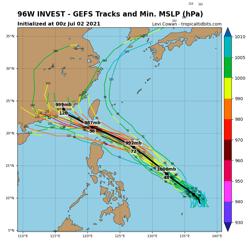
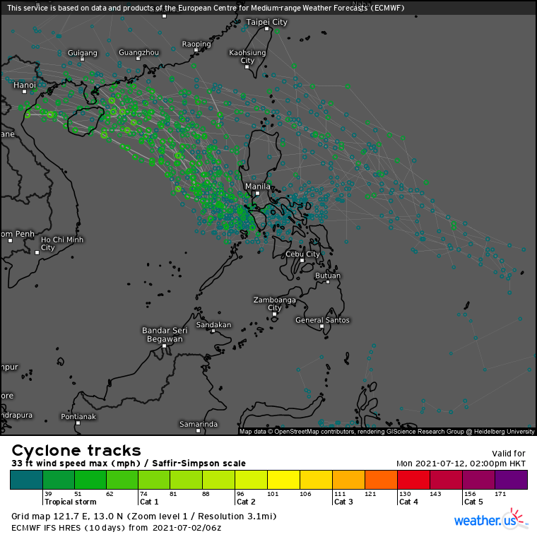
Figure 1 - GFS ensemble forecast for 07W (top) and ECMWF ensemble forecast for 08W (bottom) on July 2 [Image from Tropical Tidbits and weather.us]
圖 1 - 7 月 2 日 GFS 模式對 07W 之集成預報 (上) 及 ECMWF 模式對 08W 之集成預報 (下) [圖像取自 Tropical Tidbits 及 weather.us]

Figure 2 - Initial track forecast for 07W issued by the CWB (Taiwan)
圖 2 - 台灣中央氣象局對 07W 發出的初始預測路徑圖
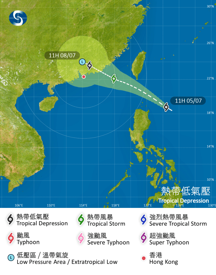
Figure 3 - HKO's track forecast for 07W at 11 am July 5
圖 3 - 7 月 5 日上午 11 時香港天文台對 07W 發出的預測路徑圖
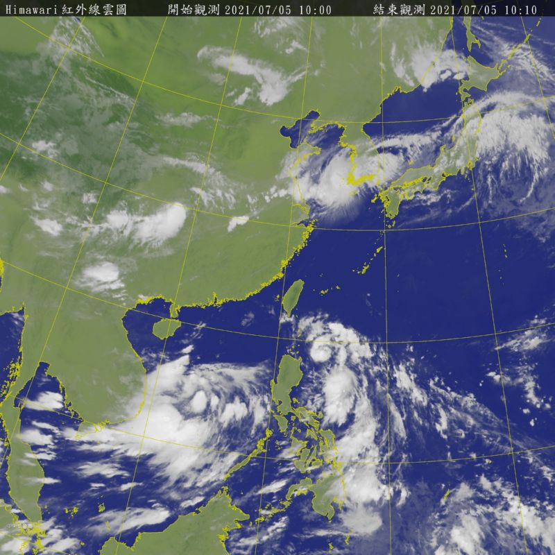
Figure 4 - Satellite image showing both systems (07W to the northeast of the Philippines; 08W in central South China Sea)
圖 4 - 衛星雲圖顯示兩個系統 - 菲律賓東北方的 07W 及 南海中部的 08W
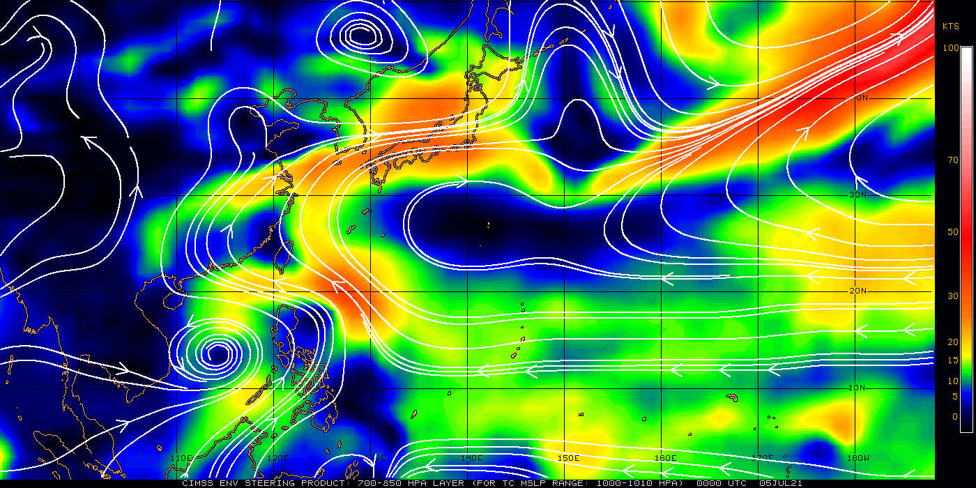
Figure 5 - Steering flow chart at 8 am July 5
圖 5 - 7 月 5 日上午 8 時之駛流場分佈圖
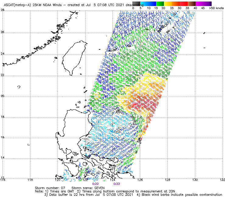
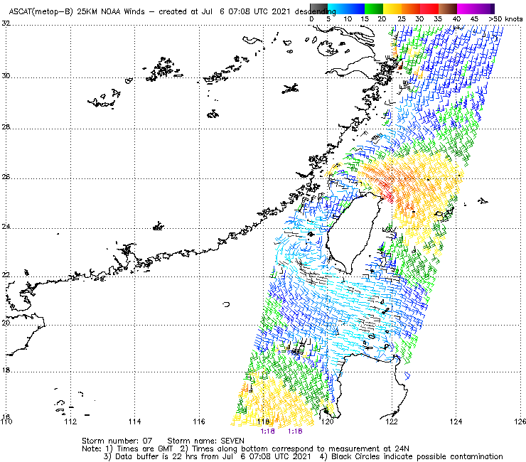
Figure 6 - Wind field analysis map for 07W at 8:22 am July 5 (top) and 9:18 am July 6 (bottom)
圖 6 - 7 月 5 日上午 8 時 22 分 (上) 及 7 月 6 日上午 9 時 18 分 (下) 之 07W 風場掃描圖
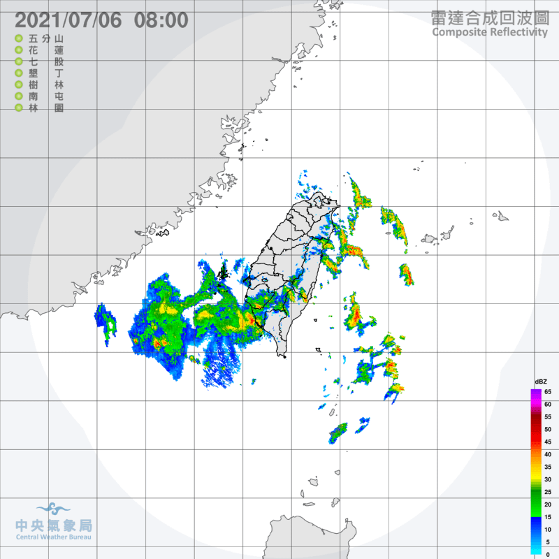
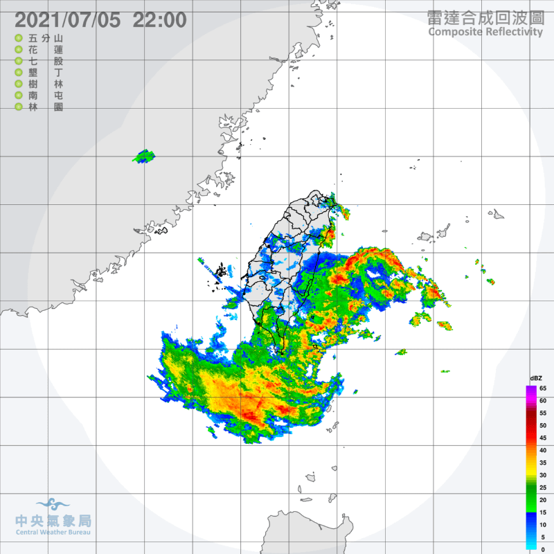
Figure 7 - Taiwan's radar images of 07W as it skirted past the southern coast of the island
圖 7 - 07W 掠過台灣南部近海時之雷達圖

Figure 8 - Forecast tracks by the HKO at noon July 6
圖 8 - 7 月 6 日中午香港天文台之預測路徑圖
Figure 9 - Radar image showing localized strong convections affecting Hong Kong in the night of July 6
圖 9 - 雷達圖顯示 7 月 6 日晚間香港受局部強對流區影響
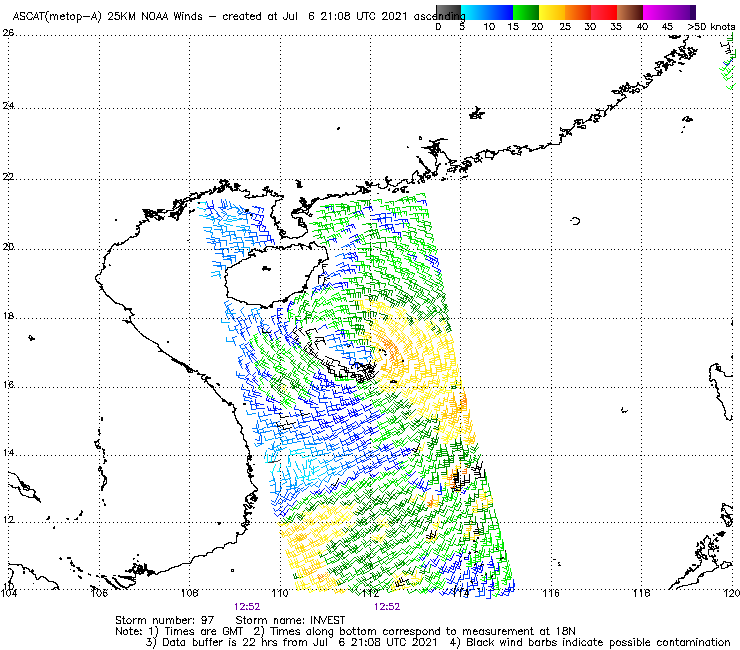
Figure 10 - Wind field analysis map for 08W at 8:52 pm July 6
圖 10 - 7 月 6 日下午 8 時 52 分之 08W 風場掃描圖

Figure 11 - Satellite image of 08W in the morning of July 7
圖 11 - 7 月 7 日上午 08W 的衛星雲圖
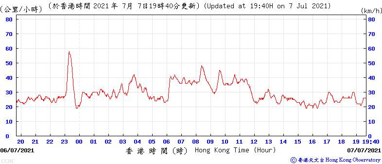
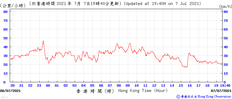
Figure 12 - Wind speed time series at Cheung Chau (top) and Waglan Island (bottom) on July 6-7
圖 12 - 長洲 (上) 及橫瀾島 (下) 於 7 月 6-7 日之風速時間序列圖
| Winds Recorded at Reference Stations 參考站所錄得的風速 |
The following table lists the maximum 10-minute average (sustained) wind speed recorded while tropical cyclone signals were in force. In some occasions, it is possible that the strongest winds were not recorded when the highest signal was in force.
下表列出各站於熱帶氣旋警告信號生效時所錄得的最高 10 分鐘平均 (持續) 風速,留意此風速不一定於最高信號生效期間錄得。
| Station 風速站 |
Max. 10-min avg. wind speed 最高十分鐘平均風速 |
Beaufort classification 蒲福氏風級分類 |
| Chek Lap Kok 赤鱲角 | 35 km/h | Fresh 清勁 |
| Cheung Chau 長洲 | 58 km/h | STRONG 強風 |
| Kai Tak 啟德 | Below "fresh" threshold of 31 km/h 低於「清勁」下限的 31 km/h | |
| Lau Fau Shan 流浮山 | 38 km/h | Fresh 清勁 |
| Sai Kung 西貢 | 39 km/h | Fresh 清勁 |
| Sha Tin 沙田 | Below "fresh" threshold of 31 km/h 低於「清勁」下限的 31 km/h | |
| Ta Kwu Ling 打鼓嶺 | Below "fresh" threshold of 31 km/h 低於「清勁」下限的 31 km/h | |
| Tsing Yi (SHL) 青衣蜆殼油庫 | 35 km/h | Fresh 清勁 |
| Number of stations recording at least STRONG force (force 6 - 7) winds: | 1 |
| Number of stations recording at least GALE force (force 8 - 9) winds: | 0 |
| Number of stations recording at least STORM force (force 10 - 11) winds: | 0 |
| Number of stations recording HURRICANE force (force 12) winds: | 0 |
| 錄得 強風 (6 - 7 級) 或更高風速的站數: | 1 |
| 錄得 烈風 (8 - 9 級) 或更高風速的站數: | 0 |
| 錄得 暴風 (10 - 11 級) 或更高風速的站數: | 0 |
| 錄得 颶風 (12 級) 風速的站數: | 0 |
| Charts and Figures 各項數據 |
Table 1: Track data from HKWW:
表一 : 香港天氣觀測站之路徑資料
Tropical cyclone 熱帶氣旋 07W
YYMMDDZZ Lat Long Wind |
Tropical cyclone 熱帶氣旋 08W
YYMMDDZZ Lat Long Wind |
Table 2: Maximum gust and hourly average wind speed recorded in Hong Kong from HKO:
表二 : 香港天文台公佈的各站最高每小時平均風力和陣風數據 (英文)
Maximum Gust |
Maximum Hourly Mean Wind |
|||||||
|---|---|---|---|---|---|---|---|---|
| Direction |
Speed (km/h) |
Date/Month |
Time |
Direction |
Speed (km/h) |
Date/Month |
Time |
|
| Central Pier | E | 56 | 6/7 | 15:38 | E | 22 | 6/7 | 22:00 |
| ESE | 22 | 7/7 | 11:00 | |||||
| Cheung Chau | SE | 69 | 6/7 | 23:09 | ESE | 40 | 7/7 | 09:00 |
| Cheung Chau Beach | E | 61 | 6/7 | 14:24 | E | 36 | 6/7 | 15:00 |
| ESE | 61 | 6/7 | 23:11 | |||||
| Hong Kong International Airport | ESE | 54 | 6/7 | 23:35 | E | 28 | 6/7 | 15:00 |
| Kai Tak | ESE | 54 | 6/7 | 15:34 | ESE | 24 | 7/7 | 11:00 |
| King's Park | E | 46 | 6/7 | 23:46 | E | 17 | 7/7 | 11:00 |
| Lamma Island | ESE | 50 | 6/7 | 14:12 | ESE | 26 | 7/7 | 10:00 |
| Lau Fau Shan | SSE | 51 | 6/7 | 16:24 | SE | 30 | 7/7 | 13:00 |
| Ngong Ping | ESE | 90 | 6/7 | 23:26 | E | 53 | 7/7 | 03:00 |
| North Point | E | 50 | 6/7 | 15:33 | E | 22 | 7/7 | 03:00 |
| Peng Chau | SE | 54 | 6/7 | 14:25 | E | 30 | 6/7 | 22:00 |
| Ping Chau | SE | 27 | 7/7 | 14:08 | E | 8 | 6/7 | 22:00 |
| Sai Kung | SSE | 50 | 6/7 | 15:43 | SSE | 30 | 7/7 | 11:00 |
| Sha Chau | SE | 52 | 6/7 | 14:52 | SE | 34 | 7/7 | 12:00 |
| SSE | 52 | 6/7 | 16:29 | |||||
| Sha Lo Wan | ESE | 54 | 7/7 | 08:28 | E | 18 | 7/7 | 00:00 |
| Sha Tin | SE | 39 | 7/7 | 09:55 | SE | 15 | 7/7 | 11:00 |
| SE | 15 | 7/7 | 12:00 | |||||
| Star Ferry (Kowloon) | E | 52 | 6/7 | 23:45 | ESE | 27 | 7/7 | 11:00 |
| Ta Kwu Ling | E | 43 | 7/7 | 03:37 | SSE | 15 | 7/7 | 13:00 |
| Tai Mei Tuk | E | 68 | 7/7 | 03:20 | E | 30 | 7/7 | 02:00 |
| Tai Mo Shan | ESE | 69 | 7/7 | 09:17 | E | 49 | 6/7 | 23:00 |
| Tai Po Kau | SSE | 50 | 6/7 | 15:56 | ESE | 25 | 7/7 | 12:00 |
| Tap Mun East | - | 62 | 7/7 | 03:56 | - | 38 | 7/7 | 04:00 |
| Tate's Cairn | SE | 65 | 6/7 | 15:37 | ESE | 37 | 7/7 | 00:00 |
| Tseung Kwan O | ESE | 36 | 6/7 | 15:33 | E | 5 | 7/7 | 09:00 |
| ESE | 5 | 7/7 | 11:00 | |||||
| Tsing Yi Shell Oil Depot | SE | 49 | 6/7 | 14:40 | SE | 24 | 6/7 | 15:00 |
| Tuen Mun Government Offices | SE | 48 | 6/7 | 14:41 | SSE | 24 | 6/7 | 15:00 |
| Waglan Island | ESE | 59 | 6/7 | 23:18 | ESE | 37 | 7/7 | 08:00 |
| ESE | 37 | 7/7 | 09:00 | |||||
| Wetland Park | S | 33 | 7/7 | 12:31 | SSE | 14 | 7/7 | 13:00 |
| S | 14 | 7/7 | 14:00 | |||||
| Wong Chuk Hang | N | 49 | 6/7 | 14:04 | N | 17 | 7/7 | 13:00 |
Table 3: Rainfall (in millimetres) contributed by 07W / 08W from HKO (figures in brackets are based on incomplete hourly data):
表三 : 香港天文台公佈的各站雨量資料 (英文) (方括號內之數據由不完整之每小時資料擷取)
| 06-Jul |
07-Jul |
Total Rainfall (mm) |
||
|---|---|---|---|---|
| Hong Kong Observatory (HKO) | 18.4 |
11.7 |
30.1 |
|
| Hong Kong International Airport (HKA) | 2.8 |
1.5 |
4.3 |
|
| Cheung Chau (CCH) | 10.0 |
0.0 |
10.0 |
|
| H23 | Aberdeen | 17.5 |
5.0 |
22.5 |
| N05 | Fanling | 3.5 |
20.0 |
23.5 |
| N13 | High Island | 7.0 |
12.5 |
19.5 |
| K04 | Jordan Valley | 7.5 |
26.0 |
33.5 |
| N06 | Kwai Chung | 2.0 |
22.0 |
24.0 |
| H12 | Mid Levels | 13.5 |
5.0 |
18.5 |
| N09 | Sha Tin | 5.5 |
10.0 |
15.5 |
| H19 | Shau Kei Wan | 17.0 |
14.5 |
31.5 |
| SEK | Shek Kong | 0.5 |
7.0 |
7.5 |
| K06 | So Uk Estate | 9.5 |
20.0 |
29.5 |
| R31 | Tai Mei Tuk | 10.0 |
15.0 |
25.0 |
| R21 | Tap Shek Kok | 0.0 |
3.0 |
3.0 |
| N17 | Tung Chung | 0.0 |
0.0 |
0.0 |
| TMR | Tuen Mun Reservoir | 0.3 |
6.8 |
7.1 |
Last Accessed 最近訪問日期: Sun Sep 08 2024 12:39:24 HKT
Last Modified 最近修訂日期: Tue Sep 26 2023
