
TC Watch / 熱帶氣旋 > Selected TC Review / 重要熱帶氣旋回顧 > 201831W (YUTU 玉兔) [Refresh 更新]
 201831W (YUTU 玉兔) - Profile 檔案 201831W (YUTU 玉兔) - Profile 檔案 |
(First draft issued on November 4, 2018; final version issued on February 14, 2019)
(初稿於 2018 年 11 月 4 日發出,最後版本於 2019 年 2 月 14 日上載)
Brief profile of YUTU | 玉兔小檔案:
| JTWC number 聯合颱風警報中心 (JTWC) 號碼 | 31W |
| International number 國際編號 | 1826 |
| Period of existence 生存時期 (JTWC) | 2018/10/21 20 HKT - 2018/11/02 08 HKT |
| Lifetime 壽命 (JTWC) | 11.50 days 日 |
| Maximum 1-minute wind (JTWC) JTWC 一分鐘平均最高中心風速 | 155 knots 節 (Category 5 Super Typhoon 五級超級颱風) |
| Minimum pressure (JTWC) JTWC 最低氣壓 | 899 hPa 百帕 |
| Highest TC signal by HKO 香港天文台發出最高熱帶氣旋警告信號 |
3 (Strong Wind Signal 強風信號) |
| Closest point of approach by HKO 香港天文台所示之最接近距離 |
SE 270 km (TC report 熱帶氣旋報告) |
| Time of closest approach by HKO 香港天文台所示之最接近時間 |
2018/11/02 11 HKT (TC report 熱帶氣旋報告) |
| Lowest pressure recorded at HKO 香港天文台錄得的最低氣壓 |
1010.5 hPa 百帕 (2018/11/01 15:38 HKT) |
TC signals in Hong Kong* 香港曾經生效的熱帶氣旋警告*:
| Signal 信號 |
Date and time 日期和時間 |
Distance from HK 與香港的距離 |
Predicted movement 預測移動趨勢 |
Max. 10-min winds 中心最高十分鐘平均風速 |
 |
2018/10/31 (WED) 08:40 HKT | SE 670 km | NW at 12 km/h | 110 km/h (60 knots, STS) |
 |
2018/11/01 (THU) 12:40 HKT | SE 360 km | N/NNW at 12 km/h | 105 km/h (55 knots, STS) |
|
2018/11/02 (FRI) 02:10 HKT | SE 300 km | N Slowly | 75 km/h (40 knots, TS) |
 |
2018/11/02 (FRI) 08:10 HKT | ESE 300 km | Slowly | 65 km/h (35 knots, TS) |
*Based on the information from real-time tropical cyclone warning bulletins.
*根據實時熱帶氣旋警報資料。
Percentile rank among storms with #3 Signal (at compilation of this review)*: *This measures the relative wind strength in Hong Kong caused by this storm compared with others that share the same signal. 指標顯示此風暴相對於其他發出同樣信號的風暴為香港帶來之風力強度 For more information, please refer to Wind Speed Data for TCs that Have Affected Hong Kong. 更多資訊載於 影響香港氣旋之風速數據 頁 |
Overall: 總計: |
|
Weak 弱 |
|||
| Component Ranks 分部等級 | ||||||
| Reference stations: 參考站: |
|
Weak 弱 |
||||
| Victoria Harbour: 維多利亞港: |
|
Weak 弱 |
||||
| Urban: 市區: |
|
Weak 弱 |
||||
| Offshore & high ground 離岸和高地: |
|
Weak 弱 |
||||
Cyclones that attained similar rating (with signal #3): TALIM (2012), MARIAN (1990) 相近級別之熱帶氣旋 (三號信號):泰利 (2012)、瑪麗安 (1990) |
||||||
IR imagery animation 紅外線雲圖動畫:
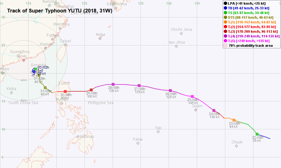
TC track from HKWW 本站的熱帶氣旋路徑圖:
TC track from HKO 天文台的熱帶氣旋路徑圖:
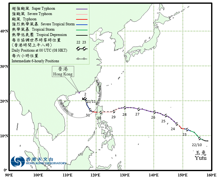
TC track with signal information 附有熱帶氣旋警告信號資料的路徑圖:
(Track figure courtesy of Lorenzo. Data from HKO. 鳴謝 Lorenzo 提供路徑圖,資料取自天文台)
| Past HKWW Bulletins 本站發佈 |
Please click here for bulletins on this tropical cyclone. 請按這裡。
| Storm Development Overview 風暴發展概覽 |
Unless otherwise stated, all times below are in Hong Kong Standard Time (UTC+8)
除非特別註明,下文時間均為香港標準時間 (協調世界時加 8 小時)
YUTU developed as a tropical disturbance some 1000 km east of Chuuk in mid-October. The JTWC issued a tropical cyclone formation alert for the system at 2 am October 21, and upgraded it into tropical depression 31W at 8 pm the same day. 31W was moving west to west-northwest along the southern periphery of a subtropical ridge to its north. Initially, the storm is expected to turn northwest and eventually recurve along a weakness in the ridge that would be induced by a propagating trough. However, there was substantial spread on the location of recurvature among the numerical models and the forecasts kept changing across model runs.
31W benefited from the very warm waters with low vertical wind shear and excellent upper-level divergence in its early life. The system intensified steadily and was upgraded into tropical storm YUTU by the JMA at 2 am October 22. YUTU maintained its west-northwestward to northwestward movement during the day; both the JTWC and JMA upgraded the storm gradually into a typhoon on October 23. By this time, numerical models were still expecting the subtropical ridge to weaken, but not sufficiently to induce a recurving scenario. Still, recurvature was the most popular prediction as another trough was expected to weaken the ridge later on in the forecast period.
As YUTU continued to traverse within an excellent atmospheric environment, it underwent rapid intensification on October 23. Within a 24-hour period from 8 am October 23 to 8 am October 24, the JTWC's assessment on YUTU's strength was adjusted upwards from 65 knots (120 km/h) to 130 knots (241 km/h), while the JMA's assessment was adjusted from 65 knots (120 km/h) to 100 knots (185 km/h). The storm developed further during October 24, forming an extremely deep central dense overcast with cloud-top temperatures persistently below -80°C around the well-defined eye in the centre devoid of clouds. The JTWC thus upgraded YUTU into category 5 strength (145 knots, 269 km/h) at 2 pm that day, and the estimated wind speed 6 hours later was at 155 knots (287 km/h). Elsewhere, the JMA's estimated wind speed was 115 knots (213 km/h), and that of the NMC (China) was 72 m/s (259 km/h).
Towards midnight October 25, YUTU's eye crossed Tinian and southern Saipan at this peak intensity. YUTU thus became the strongest tropical cyclone ever recorded to impact the Northern Mariana Islands. The storm wreaked havoc at the islands, with many structures blown loose and widespread power interruption. Shortly after passing through the islands, YUTU's cloud-top temperatures warmed as it underwent an eyewall replacement cycle. The JTWC gradually reduced its estimated wind speed to a local minimum of 130 knots (241 km/h) on October 26, still at super typhoon intensity.
As the subtropical ridge strengthened after the passage of the mid-latitude trough, YUTU turned west-northwest on October 25 and moved almost due west on October 26 and 27. By October 25, there was still substantial spread in numerical models' forecast tracks. Some predicted the storm to recurve prior to reaching northern Philippines, while others predicted that the storm would not be immediately affected by this second trough and would move into the South China Sea before recurving. Seeing this discrepancy, official forecasts generally slowed down the system in the latter part of the forecast period, with some indicating a possible turn to the northwest. However, it later became apparent that a hit at Luzon was the most likely scenario.
YUTU strengthened briefly on October 27 after it completed the eyewall replacement cycle. The JTWC reinstated its category 5 status at 2 am as its eyewall deepened again. However, this period of intensification did not last long, as it became evident from satellite images that the drier airmass near the Philippines was drawn into YUTU's circulation, leading to some degree of erosion to its eastern semicircle. The storm started to weaken again later that day.
An arriving mid-latitude trough induced a weakness in the ridge on October 28. However, the western section of the ridge remained strong and YUTU dipped south briefly during the day. It turned west again on October 29 and finally made impact in the province of Isabela in eastern Luzon early on October 30. YUTU's strength at impact was estimated to be at 90 knots (167 km/h) by the JTWC and HKO, and 85 knots (157 km/h) by the JMA.
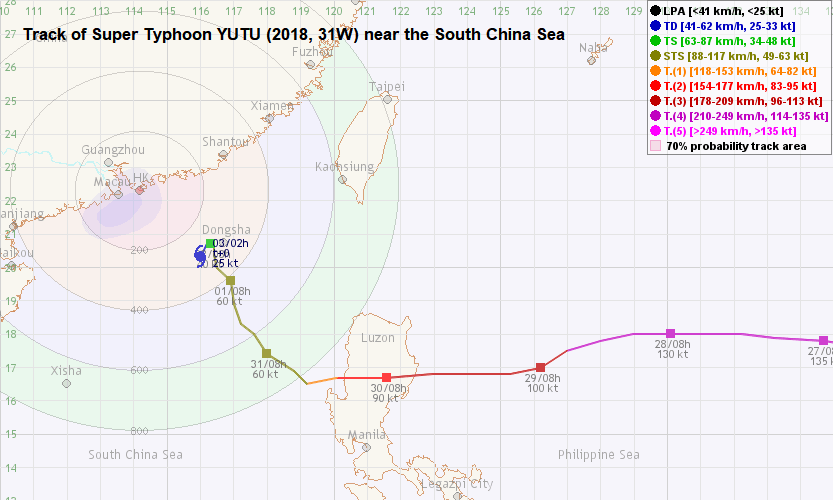
YUTU crossed Luzon during the morning and entered the South China Sea that afternoon. It slowed down significantly and its circulation continued to collapse due to the interruption by the mountainous terrain. YUTU weakened into a severe tropical storm and turned northwest to north-northwest on October 31. It gained strength slightly in its initial journey towards the north, but started to show signs of degradation on November 1 as it moved near 20°N. The combination of cooler seas, drier air mass and increased vertical wind shear served to weaken the system; YUTU gradually weakened into a tropical depression early on November 2 near Dongsha and reduced into an area of low pressure soon after.
10 月中旬,楚克島以東 1000 多公里外有一熱帶擾動發展。聯合颱風警報中心於 21 日上午 2 時對其發佈熱帶氣旋形成警報,並於當日下午 8 時將其升格為熱帶低氣壓 31W。31W 當時沿北方副熱帶高壓脊的南部向西至西北偏西移動。初時預料風暴將漸轉西北,繼而因西風槽於副高造成弱點而循該弱點轉向,但數值模式預報對轉向點出現重大分歧,而每佈計算出的預報路徑均有很大不同。
受惠於溫暖海水、低垂直風切變及極佳高空輻散,31W 形成初期穩步增強,日本氣象廳於 22 日上午 2 時將其升格為熱帶風暴玉兔。玉兔當天保持其西北偏西至西北的路徑,而聯合颱風警報中心及日本氣象廳均於 23 日逐漸將其升格為颱風。此時,數值模式仍然預計副高將減弱,但未至於令玉兔轉向。然而,由於預計較後時間會有另一條西風槽侵蝕副高,較多數值模式仍然預測玉兔會於屆時轉向。
隨著玉兔繼續經過大氣環境極佳的地區,它於 23 日出現爆發性增強。在 23 日上午 8 時至 24 日上午 8 時的 24 小時間,聯合颱風警報中心估計玉兔的風速由 65 節 (每小時 120 公里) 上調至 130 節 (每小時 241 公里),而日本氣象廳的估計則由 65 節 (每小時 120 公里) 上調至 100 節 (每小時 185 公里)。風暴於 24 日進一步發展,風眼清晰無雲,周邊的中心密集雲區非常深厚,眼牆雲頂溫度持續處於攝氏 -80 度的水平。聯合颱風警報中心遂於下午 2 時將玉兔升格至五級超級颱風強度 (145 節、每小時 269 公里),6 小時後更上調至 155 節 (每小時 287 公里)。其他機構方面,日本氣象廳及中國中央氣象台的估計分別為 115 節 (每小時 213 公里) 及每秒 72 米 (每小時 259 公里)。
25 日午夜前後,玉兔的風眼以巔峰強度橫過天寧島及塞班島南部,令玉兔成為有史以來登陸北馬里亞納群島最強的颱風。風暴於兩島造成重大破壞,大量建築物被吹散,而多處電力供應中斷。通過北馬里亞納群島後,玉兔開始進入眼牆置換周期,其眼牆雲頂溫度有所上升。聯合颱風警報中心對其強度估計下調至 26 日的 130 節 (每小時 241 公里),仍為超級颱風強度。
隨著副高於西風槽通過後再度增強,玉兔於 25 日向西北偏西移動,26 及 27 日大致西移。至 25 日,數值模式預報仍出現很大分歧,部分模式預計玉兔會於到達菲律賓前轉向,其他則預計玉兔不會即時受此西風槽影響,並將移入南海繼而轉向。此分歧令官方機構大多只將玉兔後期的預測移速調慢,部分預計風暴或轉西北移動。可是,隨著時間過去,登陸呂宋逐漸變成最大機會出現的結果。
完成眼牆置換周期後,玉兔於 27 日短暫增強,其眼牆變得深厚,聯合颱風警報中心於上午 2 時再一次估計它的風速達五級強度。可是,此輪增強維持時間很短,從衛星雲圖可見菲律賓附近的較乾燥氣流被捲入玉兔的環流,令其東半圓受侵蝕;風暴於當日後段再度呈減弱之勢。
一道西風槽令副高於 28 日出現弱點,但由於西面脊場仍然強勁,玉兔當日稍為南移。它於 29 日向西移動,並於 30 日早段登陸呂宋東部伊莎貝拉省。聯合颱風警報中心及香港天文台估計其登陸強度為 90 節 (每小時 167 公里),而日本氣象廳的估計則為 85 節 (每小時 157 公里)。
玉兔早上橫過呂宋,下午進入南海。它進入南海後明顯減速,對流因受高山擾亂而繼續崩潰。玉兔減弱為強烈熱帶風暴,於 31 日轉向西北至西北偏北移動。風暴北移初時略為增強;至 11 月 1 日風暴靠近北緯 20 度,它開始有減弱跡象。受較涼海水、乾燥氣團及垂直風切變上升的共同影響,玉兔於 2 日早段在東沙附近逐漸減弱為熱帶低氣壓,不久後進一步減弱為低壓區。
| Weather in Hong Kong During Approach 風暴影響時香港天氣狀況 |
Link to relevant HKO weather report bulletins:
31/10 ●
1/11 ●
2/11
香港天文台相關天氣報告連結:31/10 ●
1/11 ●
2/11
YUTU started to receive media attention when numerical models predicted the possibility of it moving into the South China Sea. The HKO began issuing forecast tracks on October 25 when YUTU was still well to the east of 140°E. As YUTU moved into the South China Sea in the afternoon of October 30, the HKO indicated that YUTU may turn north and that the #1 Signal would be considered on October 31.
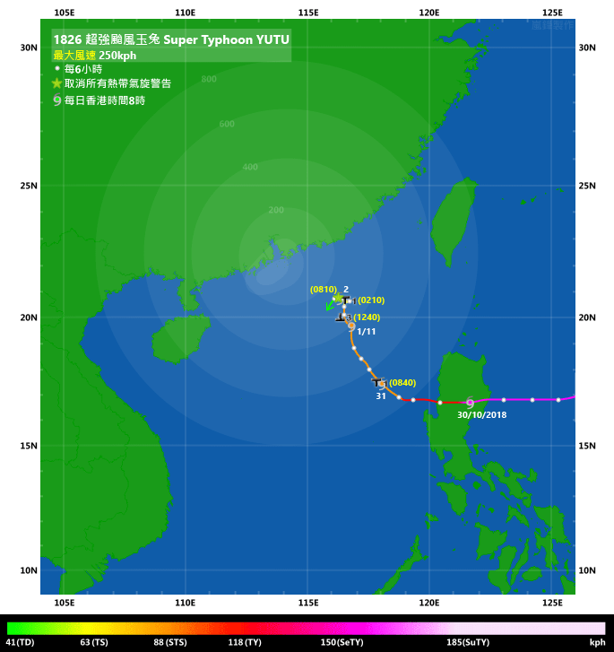
The #1 Standby Signal was issued at 8:40 am October 31, when YUTU was 670 km southeast of Hong Kong. Due to the combined effect of the northeast monsoon and YUTU, northerly winds picked up that afternoon with occasional strong winds observed in offshore areas and on high ground. Cheung Chau and Sai Kung, two of the eight reference stations, registered strong force winds briefly that day.
As YUTU moved closer to the territory, the HKO issued the #3 Strong Wind Signal at 12:40 pm November 1. YUTU was situated around 360 km southeast of Hong Kong at that time. This marked the first occasion in 25 years that the #3 Signal was issued in November, after tropical cyclone IRA on November 4, 1993. In HKO's tropical cyclone warning for shipping report, YUTU's gale radius was estimated at 180 nautical miles (333 km) in its northwestern quadrant; this means that gales were very close to the territory at one point. However, this proximity to the gale radius was not reflected in local wind speeds, which remained fresh throughout the day. The HKO also mentioned that the possibility of issuing higher signals was low unless YUTU moved closer to the Pearl River Estuary than expected.
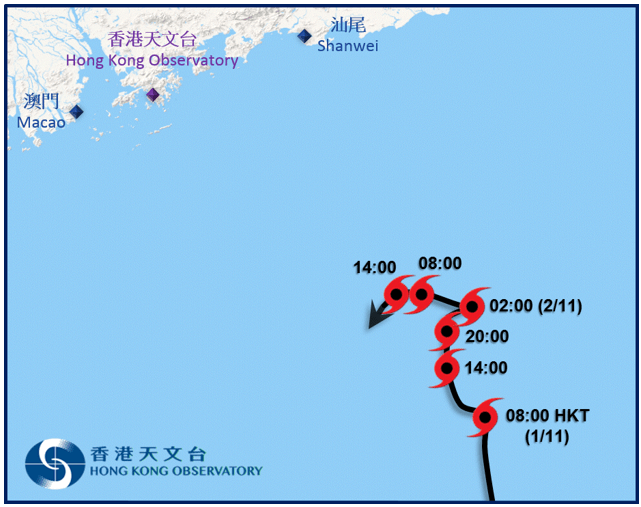
YUTU weakened during the night of November 1 and soon it became clear that sustained strong force winds would not be observed. The HKO issued the #1 Standby Signal at 2:10 am November 2 to replace the #3 Signal; YUTU was almost stationary in the seas about 300 km southeast of Hong Kong. The #1 Signal was cancelled 6 hours later as satellite images showed that YUTU had become very weak with a shallow low-level circulation centre stagnating in northern South China Sea. At a distance of about 270 km, YUTU made its closest approach to Hong Kong near 11 am that morning. Although YUTU moved west to southwest after the cancellation of tropical cyclone signals, it was too weak to have any material influence to Hong Kong.
Locally, the weather was generally fine during YUTU's approach. It was also very dry due to the prevailing northeast monsoon, with relative humidity levels dropping to below 40%. A young man was swept away while surfing in Tai Long Wan on October 31 when the #1 Signal was in force; he was later found but was pronounced dead in hospital.
當數值模式預計玉兔有機會移入南海時,風暴開始受傳媒及大眾關注。香港天文台於 10 月 25 日、玉兔仍然處於東經 140 度以東時就已對其發出路徑預測。隨著玉兔於 30 日下午移入南海,天文台表示玉兔或北轉,並將於 31 日考慮發出一號信號。
一號戒備信號於 31 日上午 8 時 40 分發出,當時玉兔位於香港東南約 670 公里。受東北季候風及玉兔的共同影響,下午本港北風增強,離岸及高地間中吹強風。在 8 個參考測風站當中,其中兩個 (長洲及西貢) 於 31 日短暫錄得強風風速。
隨著玉兔靠近本港,天文台於 11 月 1 日下午 12 時 40 分改發三號強風信號,當時玉兔已移至香港東南約 360 公里。對上一次天文台於 11 月發出三號強風信號已是 25 年前的 1993 年 11 月 4 日,受熱帶氣旋艾拉的影響而發出。在天文台的「為船舶提供的熱帶氣旋警告」中可見當時估計玉兔西北象限的烈風圈有 180 海里 (333 公里),即香港曾非常接近烈風圈邊緣。但是,本港風力未能反映這點,整天風速皆維持清勁水平。天文台亦表示除非玉兔採取較接近珠江口的路徑移動,否則改發更高信號機會不大。
玉兔於 1 日晚減弱,當確定香港不會普遍吹強風後,天文台於 2 日上午 2 時 10 分改發一號戒備信號,而玉兔正於香港東南方約 300 公里的海域徘徊。一號信號於 6 小時後取消,從衛星雲圖可見玉兔已變得非常弱,只餘一個低層環流中心於南海北部徘徊不動。玉兔於早上 11 時左右最接近香港,距離約為 270 公里。雖然信號取消後玉兔向西至西南移動,但它因強度太弱而難以對香港構成任何明顯影響。
本港方面,玉兔靠近期間天色大致良好。受東北季候風影響,本港天氣非常乾燥,相對濕度普遍下降至百分之 40 以下。10 月 31 日一號信號生效時,一名青年於大浪灣滑浪時被捲走,隨後雖被尋獲但送院後證實不治。
| Image Gallery 圖片庫 |


Figure 1 - Numerical models deterministic forecast tracks on October 22, 24 and 27 (top to bottom) obtained from typhoon2000.ph. Note the substantial spread among the tracks.
圖 1 - 10 月 22 、24 及 27 日 (上至下) 部分數值模式預報之確定性預測路徑圖 (由 typhoon2000.ph 擷取),留意預測路徑有很大差異。

Figure 2 - Initial JTWC forecast track hinting at a recurving scenario
圖 2 - 聯合颱風警報中心最初的路徑圖預計玉兔會轉向

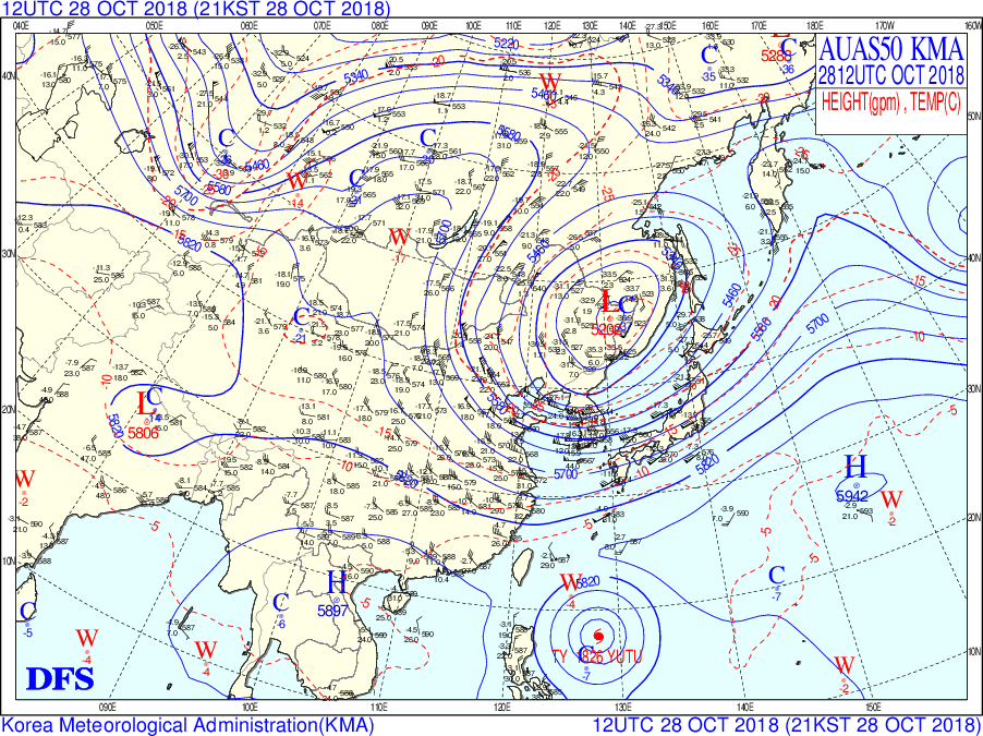
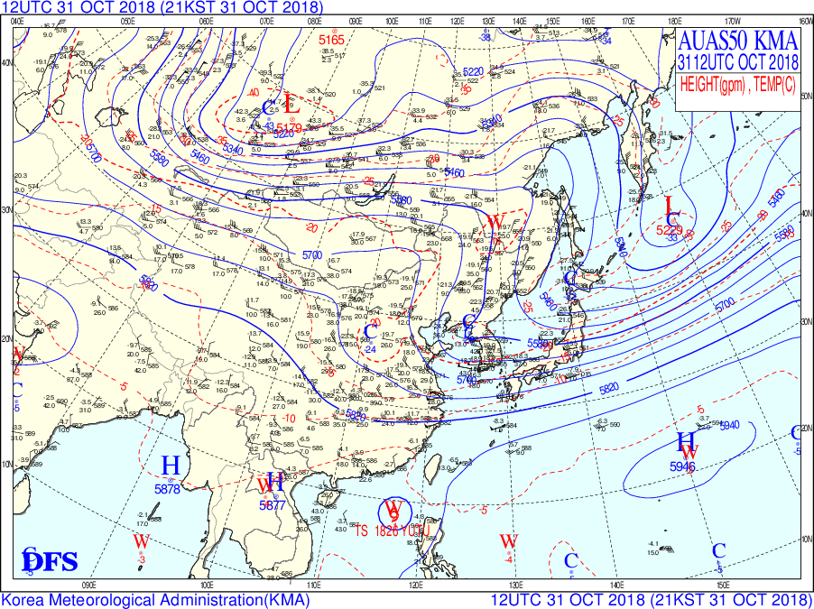
Figure 3 - 500-hPa upper-level weather charts on October 25, 28 and 31 (top to bottom), showing breaks in the subtropical ridge (area enclosed by the 5880 gpm contour)
圖 3 - 10 月 25 、28 及 31 日 (上至下) 之 500 百帕高空天氣圖,顯示副熱帶高壓脊 (5880 位勢米等高線範圍內) 出現弱點

Figure 4 - Satellite image of YUTU at its peak intensity
圖 4 - 玉兔於巔峰強度時之衛星雲圖
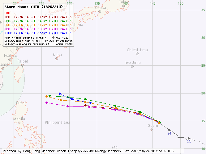
Figure 5 - Forecast track from official agencies when YUTU was at its peak intensity
圖 5 - 玉兔於巔峰強度時各官方氣象台之預測路徑圖
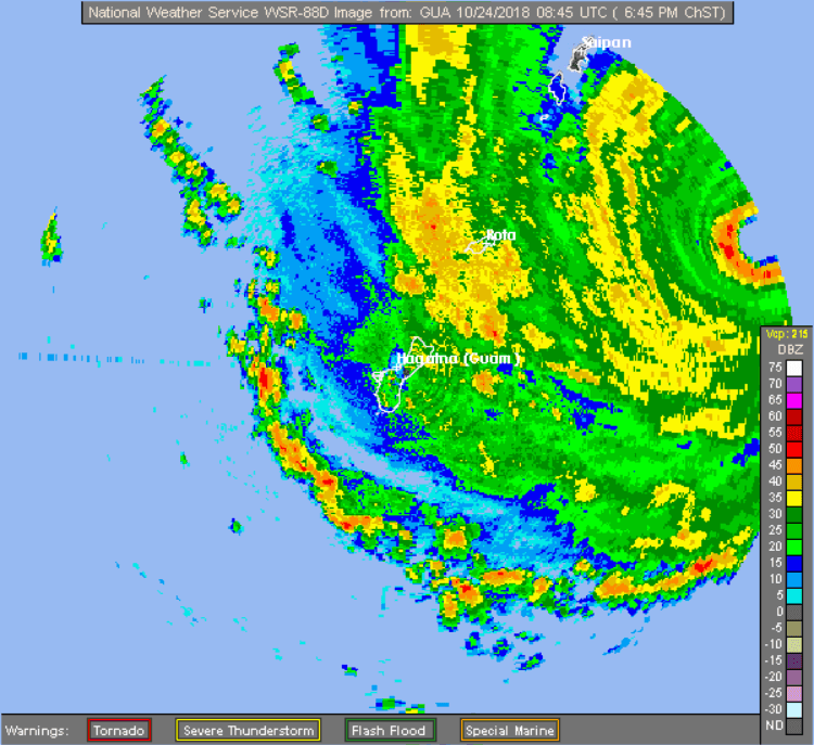
Figure 6 - Radar image of YUTU as it approached the Northern Mariana Islands
圖 6 - 玉兔靠近北馬里亞納群島時之雷達圖

Figure 7 - Satellite image of YUTU passing directly overhead Tinian and southern Saipan
圖 7 - 玉兔掠過天寧及塞班島南部上空時之衛星雲圖
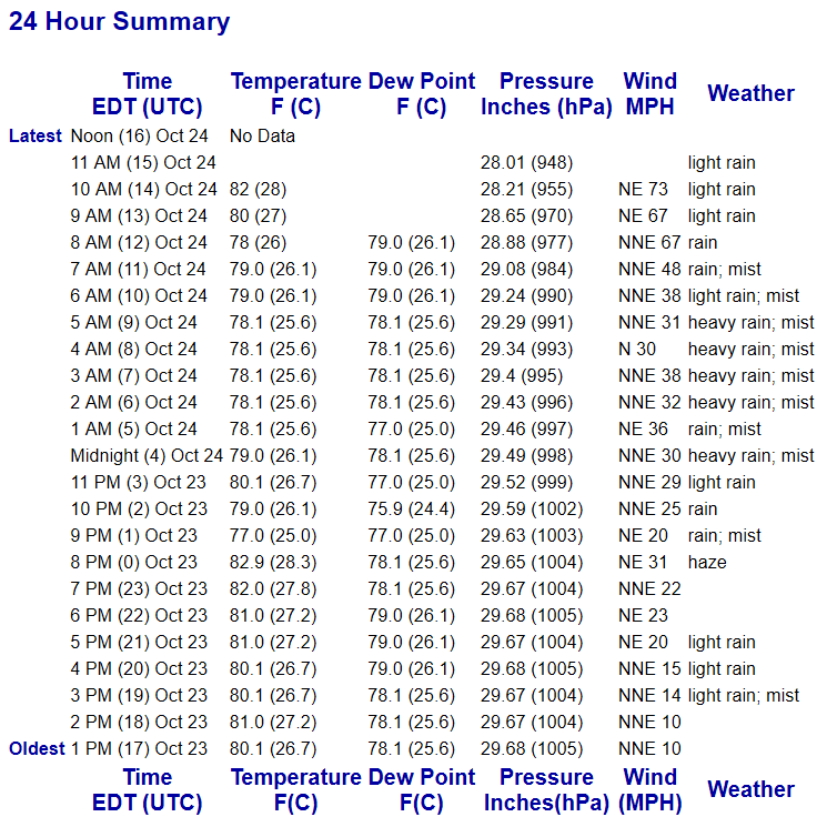
Figure 8 - A log of the weather elements recorded at Saipan during YUTU's approach. Note that the pressure dropped to 948 hPa at 11 pm October 24 (HKT) before the instrument malfunctioned.
圖 8 - 玉兔來襲時塞班島之氣象元素數據,留意當地氣壓於 10 月 24 日下午 11 時 (香港時間) 跌至 948 百帕,其後儀器失靈。
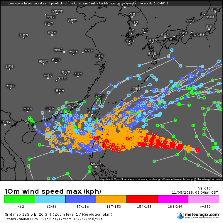
Figure 9 - ECMWF ensemble forecast on October 26. The majority of the forecast tracks indicated a recurvature before YUTU reached the Philippines. Taken from meteologix.com.
圖 9 - 10 月 26 日 ECMWF 的集成預報,大部分路徑顯示玉兔到達菲律賓前將轉向。於 meteologix.com 擷取。
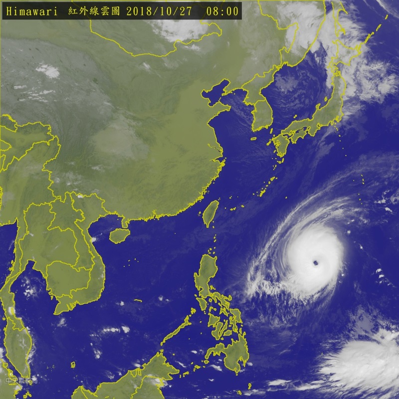
Figure 10 - Satellite image of YUTU as it strengthened again into category 5 on October 27
圖 10 - 10 月 27 日玉兔再度增強至五級超級颱風強度時之衛星雲圖


Figure 11 - Forecast track from official agencies on October 27 (left) and 29 (right)
圖 11 - 10 月 27 (左) 及 29 日 (右) 各官方氣象台之預測路徑圖
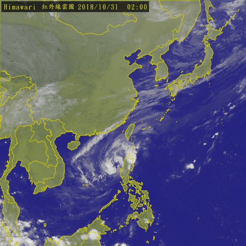
Figure 12 - YUTU weakened substantially after it crossed northern Philippines
圖 12 - 玉兔橫過菲律賓北部後明顯減弱
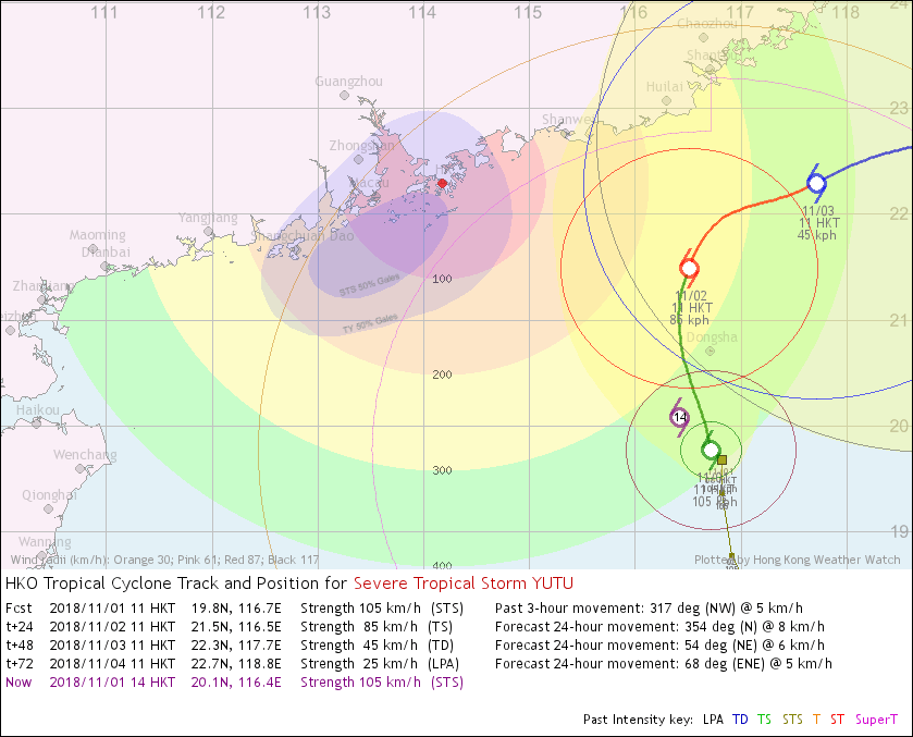
Figure 13 - HKO's forecast track at 11 am November 1. Note YUTU's large estimated gale radius.
圖 13 - 11 月 1 日上午 11 時香港天文台之預測路徑圖,留意當時估計玉兔烈風圈頗大。
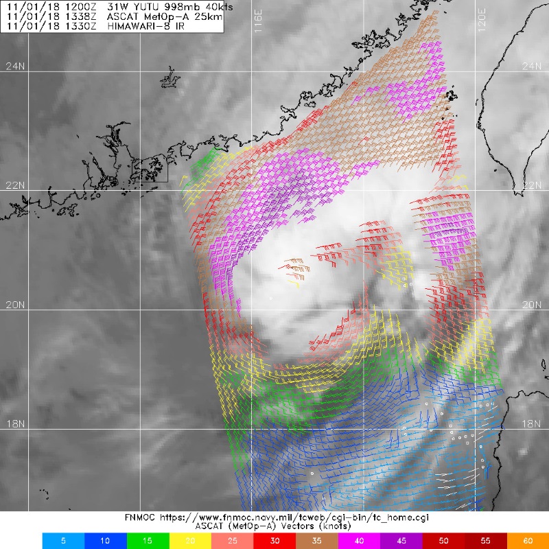
Figure 14 - Wind field analysis at 9:38 pm November 1
圖 14 - 11 月 1 日下午 9 時 38 分之風場掃描圖


Figure 15 - Visible light satellite images of YUTU at 3 pm November 1 (left) and 9 am November 2 (right). Most of its deep convections had been sheared away by the morning of November 2, leaving a completely exposed low-level circulation centre.
圖 15 - 11 月 1 日下午 3 時 (左) 及 2 日上午 9 時 (右) 之可見光衛星雲圖。至 2 日早上,玉兔大部分深層對流已被切離,只剩下完全外露的低層環流中心。
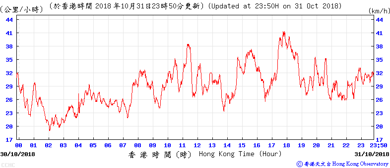
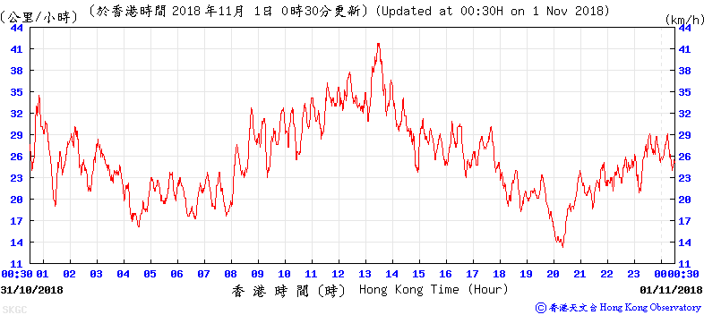
Figure 16 - Wind speed time series at Cheung Chau and Sai Kung (top to bottom) on October 31. The strongest winds during YUTU's approach were recorded before the issuance of the #3 Strong Wind Signal at both places.
圖 16 - 長洲及西貢 (上至下) 於 10 月 31 日之風速時間序列圖,兩地皆於三號強風信號發出前錄得玉兔靠近期間之最高風速。

Figure 17 - JTWC forecast track at 2 am November 2 predicting YUTU to move towards Hong Kong. This did not materialize as YUTU eventually went southwestwards.
圖 17 - 聯合颱風警報中心於 11 月 2 日上午 2 時之路徑圖預料玉兔將移向香港,但最後玉兔向西南移.此預測並未實現。
| Winds Recorded at Reference Stations 參考站所錄得的風速 |
| Station 風速站 |
Max. 10-min avg. wind speed 最高十分鐘平均風速 |
Beaufort classification 蒲福氏風級分類 |
| Chek Lap Kok 赤鱲角 | 36 km/h | Fresh 清勁 |
| Cheung Chau 長洲 | 41 km/h | STRONG 強風 |
| Kai Tak 啟德 | 24 km/h | Moderate 和緩 |
| Lau Fau Shan 流浮山 | 37 km/h | Fresh 清勁 |
| Sai Kung 西貢 | 42 km/h | STRONG 強風 |
| Sha Tin 沙田 | 22 km/h | Moderate 和緩 |
| Ta Kwu Ling 打鼓嶺 | 28 km/h | Moderate 和緩 |
| Tsing Yi (SHL) 青衣蜆殼油庫 | 28 km/h | Moderate 和緩 |
| Number of stations recording at least STRONG force (force 6 - 7) winds: | 2 |
| Number of stations recording at least GALE force (force 8 - 9) winds: | 0 |
| Number of stations recording at least STORM force (force 10 - 11) winds: | 0 |
| Number of stations recording HURRICANE force (force 12) winds: | 0 |
| 錄得 強風 (6 - 7 級) 或更高風速的站數: | 2 |
| 錄得 烈風 (8 - 9 級) 或更高風速的站數: | 0 |
| 錄得 暴風 (10 - 11 級) 或更高風速的站數: | 0 |
| 錄得 颶風 (12 級) 風速的站數: | 0 |
| Charts and Figures 各項數據 |
Table 1: Track data from HKWW:
表一 : 香港天氣觀測站之路徑資料
YYMMDDZZ Lat Long Wind |
Table 2: Maximum gust and hourly average wind speed recorded in Hong Kong from HKO:
表二 : 香港天文台公佈的各站最高每小時平均風力和陣風數據 (英文)
| Station | Maximum Gust | Maximum Hourly Mean Wind | ||||||
|---|---|---|---|---|---|---|---|---|
| Direction | Speed (km/h) |
Date/Month | Time | Direction | Speed (km/h) |
Date/Month | Time | |
| Bluff Head (Stanley) | - | 47 | 31/10 | 23:15 | - | 12 | 1/11 | 01:00 |
| - | 12 | 1/11 | 02:00 | |||||
| Central Pier | NNE | 47 | 1/11 | 02:26 | NNE | 23 | 1/11 | 03:00 |
| NE | 47 | 1/11 | 19:18 | |||||
| Cheung Chau | N | 63 | 1/11 | 22:41 | N | 36 | 31/10 | 18:00 |
| Cheung Chau Beach | NE | 68 | 1/11 | 23:02 | NNE | 31 | 2/11 | 00:00 |
| Green Island | NNE | 68 | 31/10 | 20:16 | NNE | 43 | 31/10 | 21:00 |
| Hong Kong International Airport | N | 45 | 1/11 | 16:37 | N | 31 | 1/11 | 16:00 |
| Kai Tak | NW | 49 | 31/10 | 12:45 | N | 19 | 31/10 | 13:00 |
| King's Park | NNE | 51 | 31/10 | 16:48 | NNE | 22 | 31/10 | 14:00 |
| Lau Fau Shan | N | 56 | 1/11 | 17:41 | N | 31 | 1/11 | 18:00 |
| North Point | N | 41 | 31/10 | 12:33 | N | 23 | 31/10 | 13:00 |
| N | 41 | 31/10 | 12:44 | |||||
| Peng Chau | N | 56 | 31/10 | 11:05 | N | 34 | 1/11 | 23:00 |
| N | 56 | 31/10 | 11:06 | |||||
| Ping Chau | NNE | 34 | 1/11 | 20:00 | N | 9 | 1/11 | 14:00 |
| N | 9 | 1/11 | 16:00 | |||||
| Sai Kung | N | 59 | 31/10 | 13:52 | N | 36 | 31/10 | 14:00 |
| Sha Chau | N | 56 | 1/11 | 15:48 | N | 41 | 1/11 | 18:00 |
| N | 56 | 1/11 | 15:49 | |||||
| Sha Lo Wan | NE | 41 | 31/10 | 22:02 | NE | 19 | 1/11 | 03:00 |
| Sha Tin | NNE | 41 | 31/10 | 12:36 | NNE | 19 | 31/10 | 13:00 |
| Shek Kong | NNE | 43 | 31/10 | 12:25 | NE | 20 | 31/10 | 11:00 |
| Star Ferry (Kowloon) | W | 30 | 31/10 | 13:23 | WNW | 7 | 31/10 | 13:00 |
| Ta Kwu Ling | NNE | 54 | 1/11 | 01:19 | NNE | 23 | 1/11 | 20:00 |
| NE | 54 | 1/11 | 16:25 | N | 23 | 1/11 | 22:00 | |
| Tai Mei Tuk | N | 63 | 1/11 | 18:03 | NE | 36 | 31/10 | 13:00 |
| Tai Mo Shan | NE | 88 | 31/10 | 20:36 | NE | 68 | 31/10 | 21:00 |
| Tai Po Kau | N | 43 | 31/10 | 13:46 | WNW | 19 | 1/11 | 19:00 |
| Tap Mun | N | 51 | 1/11 | 17:46 | NNW | 22 | 1/11 | 19:00 |
| N | 22 | 1/11 | 20:00 | |||||
| Tate's Cairn | N | 79 | 31/10 | 23:49 | N | 58 | 31/10 | 22:00 |
| N | 58 | 31/10 | 23:00 | |||||
| N | 58 | 1/11 | 01:00 | |||||
| NNW | 58 | 1/11 | 21:00 | |||||
| NNW | 58 | 1/11 | 22:00 | |||||
| Tseung Kwan O | NE | 43 | 1/11 | 20:56 | NE | 19 | 1/11 | 13:00 |
| Tsing Yi Shell Oil Depot | N | 56 | 1/11 | 20:24 | NNW | 23 | 1/11 | 13:00 |
| Tuen Mun Government Offices | NNE | 62 | 1/11 | 21:33 | NNE | 23 | 1/11 | 22:00 |
| Waglan Island | N | 58 | 1/11 | 15:47 | N | 49 | 1/11 | 16:00 |
| Wetland Park | NNE | 41 | 31/10 | 23:43 | NNE | 13 | 1/11 | 19:00 |
| Wong Chuk Hang | NW | 43 | 31/10 | 21:17 | W | 13 | 1/11 | 21:00 |
Table 3: Rainfall (in millimetres) contributed by YUTU from HKO (figures in brackets are based on incomplete hourly data):
表三 : 香港天文台公佈的各站雨量資料 (英文) (方括號內之數據由不完整之每小時資料擷取)
| Station | 31-Oct | 1-Nov | 2-Nov | Total Rainfall (mm) |
|
|---|---|---|---|---|---|
| Hong Kong Observatory (HKO) | 0.0 | 0.0 | 0.1 | 0.1 | |
| Hong Kong International Airport (HKA) | 0.0 | 0.2 | Trace | 0.2 | |
| Cheung Chau (CCH) | 0.0 | 0.0 | 0.0 | 0.0 | |
| H23 | Aberdeen | 0.0 | 0.0 | 0.0 | 0.0 |
| N05 | Fanling | 0.0 | 0.0 | 0.0 | 0.0 |
| N13 | High Island | 0.0 | 0.0 | 0.0 | 0.0 |
| K04 | Jordan Valley | 0.0 | 0.0 | 2.0 | 2.0 |
| N06 | Kwai Chung | 0.0 | 0.0 | 0.0 | 0.0 |
| H12 | Mid Levels | 0.0 | 0.0 | 0.0 | 0.0 |
| N09 | Sha Tin | 0.0 | 0.0 | [0.0] | [0.0] |
| H19 | Shau Kei Wan | 0.0 | 0.0 | 0.0 | 0.0 |
| SEK | Shek Kong | 0.0 | 0.0 | 0.0 | 0.0 |
| K06 | So Uk Estate | 0.0 | 0.0 | 1.5 | 1.5 |
| R31 | Tai Mei Tuk | 0.0 | 0.5 | 0.0 | 0.5 |
| R21 | Tap Shek Kok | 0.0 | 0.0 | 0.0 | 0.0 |
| N17 | Tung Chung | 0.0 | 0.0 | 0.0 | 0.0 |
| TMR | Tuen Mun Reservoir | 0.0 | 0.0 | 0.0 | 0.0 |
Last Accessed 最近訪問日期: Sun Sep 08 2024 12:35:02 HKT
Last Modified 最近修訂日期: Mon Jul 24 2023
