
TC Watch / 熱帶氣旋 > Selected TC Review / 重要熱帶氣旋回顧 > 201616W (MERANTI 莫蘭蒂) [Refresh 更新]
 201616W (MERANTI 莫蘭蒂) - Profile 檔案 201616W (MERANTI 莫蘭蒂) - Profile 檔案 |
(Issued on October 11, 2016)
(於 2016 年 10 月 11 日發出)
Brief profile of MERANTI | 莫蘭蒂小檔案:
| JTWC number 聯合颱風警報中心 (JTWC) 號碼 | 16W |
| International number 國際編號 | 1614 |
| Period of existence 生存時期 (JTWC) | 2016/09/09 02 HKT - 2016/09/16 02 HKT |
| Lifetime 壽命 (JTWC) | 7.00 days 日 |
| Maximum 1-minute wind (JTWC) JTWC 一分鐘平均最高中心風速 | 165 knots 節 (Category 5 Super Typhoon 五級超級颱風) |
| Minimum pressure (JTWC) JTWC 最低氣壓 | 887 hPa 百帕 |
| Highest TC signal by HKO (if applicable) 香港天文台發出最高熱帶氣旋警告信號 |
1 (Standby Signal 戒備信號) |
| Closest point of approach by HKO (if applicable) 香港天文台所示之最接近距離 (如適用) |
NE 460 km (TC report 熱帶氣旋報告) |
| Time of closest approach by HKO (if applicable) 香港天文台所示之最接近時間 (如適用) |
2016/09/15 11 HKT (TC report 熱帶氣旋報告) |
| Lowest pressure recorded at HKO (if applicable) 香港天文台錄得的最低氣壓 (如適用) |
1001.3 hPa 百帕 (2016/09/14 15:31 HKT) |
TC signals for Hong Kong & Track 香港曾經生效的熱帶氣旋警告和路徑圖:
Table 表:
| Signal 信號 |
Date and time 日期和時間 |
Distance from HK 與香港的距離 |
Predicted movement 預測移動方向和速度 |
Max. 10-min winds 中心最高十分鐘平均風速 |
 |
2016/09/14 (WED) 10:10 HKT | E 660 km | NW/WNW at 22 km/h | 220 km/h (120 knots, SuT) |
 |
2016/09/15 (THU) 04:20 HKT | ENE 500 km | NW/WNW at 20 km/h | 155 km/h (85 knots, ST) |
Figure 圖:
(Track figure courtesy of Lorenzo. Data from HKO. 鳴謝 Lorenzo 提供路徑圖,資料取自天文台)
IR imagery animation 紅外線雲圖動畫:
TC track from HKWW 本站的熱帶氣旋路徑圖:

TC track from HKO 天文台的熱帶氣旋路徑圖:

| Past HKWW Bulletins 本站發佈 |
Please click here for bulletins on this tropical cyclone. 請按這裡。
| Storm Development Overview 風暴發展概覽 |
Unless otherwise stated, all times below are in Hong Kong Standard Time (UTC+8)
除非特別註明,下文時間均為香港標準時間 (協調世界時加 8 小時)
A tropical disturbance near Guam intensified into tropical depression 16W on September 9. 16W was under the influence of the Pacific subtropical ridge and was moving west-northwest in its southern periphery. It developed steadily in warm seas and the JMA upgraded it into a tropical storm at 2 pm September 10, naming it MERANTI. Its track speed increased on September 11 as it intensified into a typhoon.
As MERANTI moved into a pool of warmer waters, it underwent explosive deepening on September 12. The JTWC's assessment was adjusted upwards from 115 knots (213 km/h) at 8 am that day to 155 knots (287 km/h) 12 hours later. MERANTI developed a deep central dense overcast that night; its intensity was revised to 160 knots (296 km/h) on September 13 and further to 165 knots (306 km/h) early September 14 as the storm crossed the Luzon Strait. At the same time, the intensity assessments by the HKO, JMA, the NMC of China and CWB of Taiwan were 130 knots (240 km/h), 120 knots (222 km/h), 68 m/s (245 km/h) and 58 m/s (209 km/h) respectively. MERANTI's eye passed through the island of Itbayat at around 1:30 am; hourly wind and sea level pressure measurements of 180 km/h and 934 hPa were recorded at 1 am.
MERANTI moved at a more northerly direction in the morning of September 14, passing just south of Hengchun. The storm started to weaken due to its proximity to landmass, but remained a significant typhoon. As the subtropical ridge retreated and the storm reached its southwestern periphery, it turned north-northwest and made landfall near Xiamen early on September 15. The storm weakened more rapidly after landfall and became an area of low pressure on September 16.
於關島附近的一個熱帶擾動於 9 月 9 日增強為熱帶低氣壓 16W。16W 當時處於太平洋副熱帶高壓脊南沿,受其影響向西北偏西移動。它於溫暖海域中穩定發展,日本氣象廳於 10 日下午 2 時將其升格為熱帶風暴,並命名為莫蘭蒂。莫蘭蒂於 11 日增強為颱風,移速有所增加。
隨著莫蘭蒂進入更暖海域,它於 12 日出現爆發性增強。聯合颱風警報中心對其估算強度由當天上午 8 時的 115 節 (每小時 213 公里) 上調至 12 小時後的 155 節 (每小時 287 公里)。莫蘭蒂當晚發展出一深厚中心密集雲區,於 13 日進一步增強至 160 節 (每小時 296 公里),至 14 日凌晨更以 165 節 (每小時 306 公里) 強度橫過呂宋海峽。與此同時,香港天文台、日本氣象廳、中國氣象台及台灣中央氣象局估計其強度分別為 130 節 (每小時 240 公里)、120 節 (每小時 222 公里)、每秒 68 米 (每小時 245 公里) 及 每秒 58 米 (每小時 209 公里)。莫蘭蒂的風眼於上午 1 時 30 分左右橫過伊巴雅特島,當地於上午 1 時錄得整點風速及海平面氣壓分別為每小時 180 公里及 934 百帕斯卡。
莫蘭蒂於 14 日早上採取較北方向移動,掠過恆春以南海域。由於風暴靠近陸地,它開始減弱,但仍為一較強勁颱風。隨著副熱帶高壓脊東退,風暴處於其西南沿,它轉向西北偏北移動,於 15 日早段登陸廈門。登陸後,風暴的減弱速度加快,最終於 16 日減弱為一低壓區。
| Weather in Hong Kong During Approach 風暴影響時香港天氣狀況 |
Link to relevant HKO weather report bulletins: 14/9 15/9
香港天文台相關天氣報告連結:14/9 15/9
Due to MERANTI's subsidence, it was very hot and hazy in Hong Kong on September 14. The #1 Standby Signal was issued at 10:10 am that day as the storm entered the South China Sea as a super typhoon, when it was 660 km east of Hong Kong. As the storm turned northwest earlier than expected, it maintained a considerable distance from the territory and there was no significant impact.
The #1 Standby Signal was cancelled at 4:20 am September 15, after MERANTI had made landfall in Fujian. However, the storm turned northwest briefly after landfall and was actually closest to Hong Kong later at 11 am, at a distance of 460 km.
受莫蘭蒂相關的下沉氣流影響,香港於 9 月 14 日天氣酷熱,並有煙霞。莫蘭蒂當天以超級颱風強度進入南海,香港天文台於上午 10 時 10 分發出一號戒備信號,當時風暴集結於香港以東約 660 公里。由於莫蘭蒂比預期較早轉向西北,它一直與香港保持一段距離,並未有造成明顯影響。
莫蘭蒂登陸後,天文台於 15 日上午 4 時 20 分取消一號戒備信號,但風暴其後短暫向西北移動,至上午 11 時才最為接近香港,當時距離為 460 公里。
| Image Gallery 圖片庫 |


Figure 1 - Forecast tracks from official agencies, September 10 (left) and 13 (right)
圖 1 - 9 月 10 日 (左) 及 13 日 (右) 各官方氣象台之預測路徑圖

Figure 2 - Steering flow chart at 8 am September 12
圖 2 - 9 月 12 日上午 8 時之駛流場圖


Figure 3 - Satellite images of MERANTI on September 10 (left), 12 (middle) and 14 (right)
圖 3 - 9 月 10 (左)、12 (中) 及 14 日 (右) 莫蘭蒂之衛星雲圖
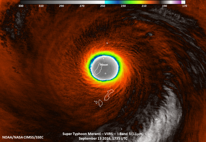
Figure 4 - Satellite imagery at 1:35 am September 13 showing MERANTI's eye over the island of Itbayat [Source: here]
圖 4 - 9 月 13 日上午 1 時 35 分的衛星雲圖顯示莫蘭蒂的風眼於伊巴雅特島上空 [來源按此]


Figure 5 - Colour-enhanced infrared satellite images showing MERANTI's deep-layered central dense overcast with very low cloud-top temperatures in the night of September 13-14
圖 5 - 9 月 13-14 日晚之色調強化衛星雲圖可見莫蘭蒂的深層中心密集雲區,其雲頂溫度極低
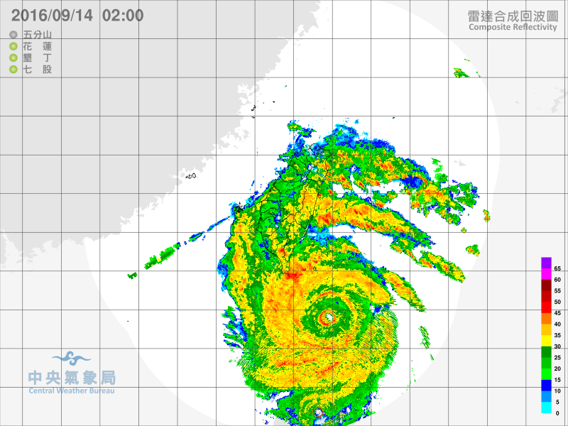
Figure 6 - Radar image at 2 am September 14
圖 6 - 9 月 14 日上午 2 時之雷達圖

Figure 7 - JTWC's forecast track at 2 am September 14
圖 7 - 聯合颱風警報中心於 9 月 14 日上午 2 時之預測路徑圖

Figure 8 - Calculated wind field distribution chart at 2 am September 14
圖 8 - 9 月 14 日上午 2 時之估算風場分布圖
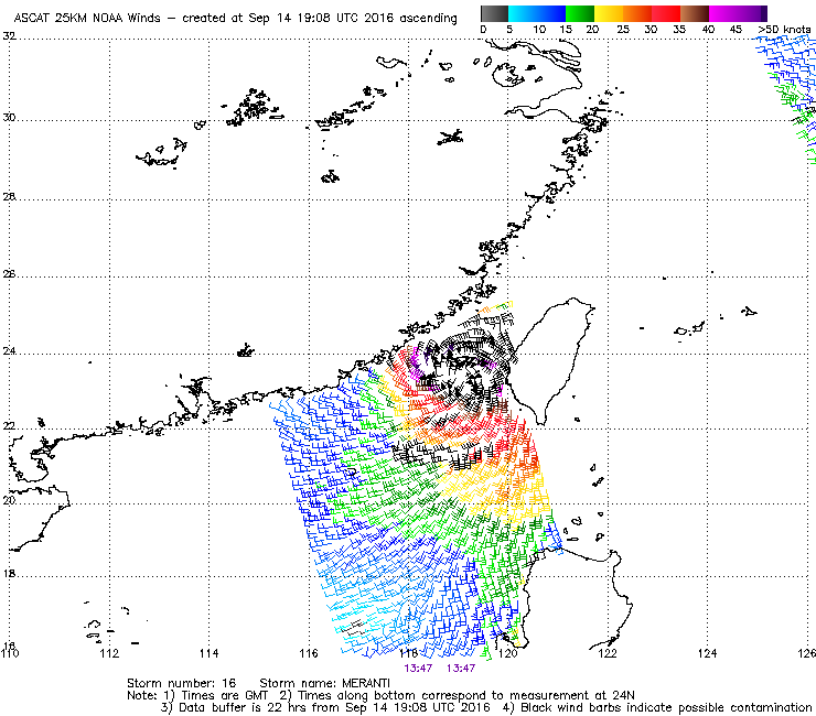
Figure 9 - Wind field analysis at 9:47 pm September 14
圖 9 - 9 月 14 日下午 9 時 47 分之風場分析圖

Figure 10 - Weather observations at Kinmen from the CWB showing a minimum sea level pressure of 950 hPa when MERANTI made landfall there
圖 10 - 台灣中央氣象台提供的金門天氣觀測數據顯示莫蘭蒂登陸該處時海平面氣壓跌至 950 百帕斯卡
| Winds Recorded at Reference Stations 參考站所錄得的風速 |
(Except for special cases, this section is not available for cyclones that only necessitated the Standby Signal 除非特別情況,否則此部只當氣旋令天文台發出三號或更高信號時提供)
| Charts and Figures 各項數據 |
Table 1: Track data from HKWW:
表一 : 香港天氣觀測站之路徑資料
YYMMDDZZ Lat Long Wind |
Table 2: Maximum gust and hourly average wind speed recorded in Hong Kong from HKO:
表二 : 香港天文台公佈的各站最高每小時平均風力和陣風數據 (英文)
| Station | Maximum Gust |
Maximum Hourly Mean Wind |
||||||
|---|---|---|---|---|---|---|---|---|
Direction |
Speed (km/h) |
Date/Month |
Time |
Direction |
Speed (km/h) |
Date/Month |
Time |
|
| Bluff Head (Stanley) | NW |
27 |
14/9 |
14:05 |
NW |
14 |
14/9 |
16:00 |
| Central Pier | W |
41 |
14/9 |
16:25 |
WNW |
22 |
14/9 |
20:00 |
| Cheung Chau | NNW |
43 |
14/9 |
16:17 |
NW |
25 |
14/9 |
18:00 |
NW |
43 |
14/9 |
17:30 |
|||||
| Cheung Chau Beach | WNW |
43 |
14/9 |
16:27 |
WNW |
19 |
14/9 |
16:00 |
| Green Island | NNW |
49 |
14/9 |
19:15 |
NNW |
31 |
14/9 |
21:00 |
| Hong Kong International Airport | NNW |
40 |
14/9 |
17:25 |
NNW |
31 |
14/9 |
23:00 |
| Kai Tak | W |
38 |
14/9 |
15:44 |
NW |
22 |
14/9 |
17:00 |
| King's Park | NNW |
34 |
14/9 |
22:36 |
N |
13 |
14/9 |
21:00 |
| Lau Fau Shan | WNW |
40 |
14/9 |
15:56 |
NNW |
30 |
14/9 |
19:00 |
WNW |
40 |
14/9 |
15:59 |
|||||
WNW |
40 |
14/9 |
16:00 |
|||||
| Ngong Ping | WNW |
41 |
14/9 |
14:34 |
WNW |
25 |
14/9 |
15:00 |
| North Point | WSW |
40 |
14/9 |
15:09 |
WSW |
27 |
14/9 |
16:00 |
| Peng Chau | WNW |
45 |
14/9 |
15:43 |
WNW |
30 |
14/9 |
17:00 |
| Ping Chau | WNW |
23 |
14/9 |
13:24 |
NW |
9 |
14/9 |
21:00 |
| Sai Kung | NNW |
41 |
14/9 |
23:15 |
NNE |
23 |
14/9 |
11:00 |
| Sha Chau | NNW |
49 |
14/9 |
17:23 |
NNW |
30 |
15/9 |
00:00 |
| Sha Lo Wan | W |
27 |
14/9 |
14:12 |
W |
12 |
14/9 |
14:00 |
| Sha Tin | N |
30 |
15/9 |
01:40 |
N |
12 |
15/9 |
02:00 |
N |
12 |
15/9 |
03:00 |
|||||
| Shek Kong | WNW |
31 |
14/9 |
13:21 |
WNW |
12 |
14/9 |
14:00 |
| Star Ferry (Kowloon) | WNW |
36 |
14/9 |
17:40 |
W |
25 |
14/9 |
16:00 |
| Ta Kwu Ling | WNW |
30 |
14/9 |
16:57 |
NNW |
12 |
14/9 |
15:00 |
| Tai Mei Tuk | NE |
36 |
14/9 |
15:42 |
ENE |
14 |
14/9 |
11:00 |
| Tai Mo Shan | NNW |
58 |
14/9 |
21:35 |
NNW |
40 |
14/9 |
22:00 |
| Tai Po Kau | WNW |
38 |
14/9 |
15:28 |
NW |
19 |
14/9 |
15:00 |
| Tap Mun | W |
36 |
14/9 |
21:25 |
WNW |
14 |
14/9 |
14:00 |
| Tate's Cairn | NNW |
58 |
14/9 |
22:53 |
NNW |
45 |
15/9 |
00:00 |
| Tseung Kwan O | N |
31 |
14/9 |
21:32 |
N |
12 |
14/9 |
22:00 |
N |
12 |
14/9 |
23:00 |
|||||
| Tsing Yi Shell Oil Depot | NW |
36 |
14/9 |
20:06 |
WNW |
19 |
14/9 |
17:00 |
| Tuen Mun Government Offices | W |
41 |
14/9 |
17:19 |
WNW |
14 |
14/9 |
15:00 |
WNW |
14 |
14/9 |
16:00 |
|||||
| Waglan Island | WNW |
41 |
14/9 |
15:28 |
WNW |
30 |
14/9 |
16:00 |
| Wetland Park | NNW |
30 |
14/9 |
17:11 |
NNW |
13 |
14/9 |
18:00 |
Table 3: Rainfall (in millimetres) contributed by MERANTI from HKO (figures in brackets are based on incomplete hourly data):
表三 : 香港天文台公佈的各站雨量資料 (英文) (方括號內之數據由不完整之每小時資料擷取)
| Station | 14 Sep | 15 Sep |
Total Rainfall (mm) |
|
|---|---|---|---|---|
| Hong Kong Observatory (HKO) | 0.0 |
0.7 |
0.7 |
|
| Hong Kong International Airport (HKA) | 0.0 |
0.0 |
0.0 |
|
| Cheung Chau (CCH) | 0.0 |
0.0 |
0.0 |
|
| H23 | Aberdeen | 0.0 |
0.0 |
0.0 |
| N05 | Fanling | 0.0 |
0.0 |
0.0 |
| N13 | High Island | 0.0 |
1.0 |
1.0 |
| K04 | Jordan Valley | 0.0 |
0.0 |
0.0 |
| N06 | Kwai Chung | 0.0 |
0.0 |
0.0 |
| H12 | Mid Levels | 0.0 |
0.0 |
0.0 |
| SHA | Sha Tin | 0.0 |
0.0 |
0.0 |
| H19 | Shau Kei Wan | 0.0 |
0.0 |
0.0 |
| SEK | Shek Kong | 0.0 |
0.0 |
0.0 |
| K06 | So Uk Estate | 0.0 |
0.5 |
0.5 |
| R31 | Tai Mei Tuk | 0.0 |
0.0 |
0.0 |
| R21 | Tap Shek Kok | 0.0 |
0.0 |
0.0 |
| N17 | Tung Chung | 0.0 |
0.0 |
0.0 |
Last Accessed 最近訪問日期: Sun Sep 08 2024 12:48:01 HKT
Last Modified 最近修訂日期: Mon Jul 24 2023
