
TC Watch / 熱帶氣旋 > Selected TC Review / 重要熱帶氣旋回顧 > 201601W [Refresh 更新]
 201601W - Profile 檔案 201601W - Profile 檔案 |
(Issued on June 21, 2016)
(於 2016 年 6 月 21 日發出)
Brief profile of 01W | 01W 小檔案:
| JTWC number 聯合颱風警報中心 (JTWC) 號碼 | 01W (Assigned in post-analysis 於事後評估給予) |
| International number 國際編號 | ---- |
| Period of existence 生存時期 (HKO)* | 2016/05/26 20 HKT - 2016/05/27 20 HKT |
| Lifetime 壽命 (HKO)* | 1.00 days 日 |
| Maximum wind (HKO estimate) 香港天文台估計平均最高中心風速* | 25 knots 節 (Tropical Depression 熱帶低氣壓)** |
| Highest TC signal by HKO (if applicable) 香港天文台發出最高熱帶氣旋警告信號 |
3 (Strong Wind Signal 強風信號) |
| Closest point of approach by HKO (if applicable) 香港天文台所示之最接近距離 (如適用) |
W 170 km (real-time warning 實時報告 and 及 TC report 熱帶氣旋報告) |
| Time of closest approach by HKO (if applicable) 香港天文台所示之最接近時間 (如適用) |
2016/05/27 20 HKT (real-time warning and TC report 實時報告及熱帶氣旋報告) |
| Lowest pressure recorded at HKO (if applicable) 香港天文台錄得的最低氣壓 (如適用) |
1004.7 hPa 百帕 (2016/05/27 17:40 HKT) |
*As the JTWC did not consider this system a tropical cyclone in its live bulletins, estimates from the HKO are used instead.
*由於聯合颱風警報中心於實時發佈中未將此系統視為熱帶氣旋,此項資料改用香港天文台的估計。
**Adjusted to 30 knots in TC report.
**於熱帶氣旋報告中上調至 30 節。
TC signals for Hong Kong & Track 香港曾經生效的熱帶氣旋警告和路徑圖:
Table 表:
| Signal 信號 |
Date and time 日期和時間 |
Distance from HK 與香港的距離 |
Predicted movement 預測移動方向和速度 |
Max. 10-min winds 中心最高十分鐘平均風速 |
 |
2016/05/26 (THU) 21:40 HKT | SSW 370 km | NNW at 18 km/h | 45 km/h (25 knots, TD) |
 |
2016/05/27 (FRI) 05:40 HKT | SW 240 km | N/NNW at 20 km/h | 45 km/h (25 knots, TD) |
|
2016/05/27 (FRI) 13:40 HKT | WSW 220 km | N/NNW at 20 km/h | 45 km/h (25 knots, TD) |
 |
2016/05/27 (FRI) 22:50 HKT | WNW 180 km | N at 22 km/h | 45 km/h (25 knots, TD) |
Figure 圖:
(Track figure courtesy of Lorenzo. Data from HKO. 鳴謝 Lorenzo 提供路徑圖,資料取自天文台)
Percentile rank among storms with #3 Signal (at compilation of this review)*: *This measures the relative wind strength in Hong Kong caused by this storm compared with others that share the same signal. 指標顯示此風暴相對於其他發出同樣信號的風暴為香港帶來之風力強度 For more information, please refer to Wind Speed Data for TCs that Have Affected Hong Kong. 更多資訊載於 影響香港氣旋之風速數據 頁 |
Overall: 總計: |
|
Moderately weak 中等偏弱 |
|||
| Component Ranks 分部等級 | ||||||
| Reference stations: 參考站: |
|
Moderately weak 中等偏弱 |
||||
| Victoria Harbour: 維多利亞港: |
|
Moderately weak 中等偏弱 |
||||
| Urban: 市區: |
|
Moderately weak 中等偏弱 |
||||
| Offshore & high ground 離岸和高地: |
|
Weak 弱 |
||||
Cyclones that attained similar rating (with signal #3): JEBI (2013), RUMBIA (2013), MEGI (2010), FANAPI (2010), noname (2006/9) 相近級別之熱帶氣旋 (三號信號):飛燕 (2013), 溫比亞 (2013), 鮎魚 (2010), 凡亞比 (2010), 無名 (2006/9) |
||||||
IR imagery animation 紅外線雲圖動畫:
TC track from HKWW 本站的熱帶氣旋路徑圖:

TC track from HKO 天文台的熱帶氣旋路徑圖:


| Past HKWW Bulletins on 01W 本站有關 01W 的發佈 |
Please click here for bulletins on 01W. 請按這裡。
| Storm Formation and Development 氣旋形成和發展 |
Unless otherwise stated, all times below are in Hong Kong Standard Time (UTC+8)
除非特別註明,下文時間均為香港標準時間 (協調世界時加 8 小時)
01W is the first tropical cyclone to necessitate tropical cyclone signals in Hong Kong this year.
A trough of low pressure persisted in southern China and northern South China Sea in the latter parts of May. The first signs of possible tropical cyclone development within the trough were suggested by some numerical forecast models near May 20. On May 23, the Hong Kong Observatory projected that the trough would edge closer to south China coastal areas later that week and would bring showers to the region.
The trough gained spiral characteristics and evolved into an area of low pressure between May 24 and May 25. The JTWC assigned the disturbance number 90W to the system (it should be noted that the storm number 01W, which we will use throughout this review, was assigned retrospectively). As convections continued to wrap around the centre, the JTWC issued a tropical cyclone formation alert at 8 am May 26. At that time, the subtropical ridge was covering much of tropical northwestern Pacific, extending into part of the South China Sea. As 01W was west of that ridge, the initial forecast had 01W move north towards the vicinity of Hong Kong.
Meanwhile, the HKO mentioned the possibility of the trough developing into a monsoon depression in the 9-day weather forecast near noon on May 26, and suggested occasional force 6 winds (strong force) may be observed offshore on May 27. Wind field scans that morning depicted a well-defined low-level circulation centre around 200 km northeast of the Paracel Islands. The HKO confirmed 01W's monsoon depression status in the afternoon, and upgraded the system into a tropical depression that night. By that time, 01W was only about 370 km SSW of Hong Kong, and therefore the HKO issued the #1 Standby Signal at 9:40 pm along with the upgrade.
In its tropical cyclone report, the HKO indicated that the chance of issuing the Strong Wind Signal is not high as local winds were not expected to strengthen significantly that night and early next morning. Easterly winds were prevailing locally; winds were generally strengthening during the night of May 26, especially at stations free of obstruction towards the east. Strong force winds were observed at Cheung Chau, Green Island, Tai Mei Tuk, Tate's Cairn and Waglan Island, and gale force winds at Ngong Ping.
Early on May 27, the HKO maintained that chances for higher signals were not high. However, as 01W moved north, it changed its stance and predicted stronger winds when local winds veered to the south. The #3 Strong Wind Signal was issued at 5:40 am, meaning that classes of kindergartens and some special schools were suspended for the day. That morning, wind direction at most stations indeed veered to the southeast, but this was not accompanied by an increase in wind speed.
01W 是本年首個令香港天文台發出熱帶氣旋警告信號的熱帶氣旋。
5 月下旬,一道低壓槽於華南及南海北部徘徊,部分數值預報模式於 20 日前後預測稍後槽內或有熱帶氣旋活動。至 23 日,天文台預計該低壓槽將於該周後期靠近華南沿岸,並為該區帶來驟雨。
其後該低壓槽螺旋性漸見明顯,並於 24 至 25 日發展為一低壓區,聯合颱風警報中心對其發出擾動編號 90W (註:聯合颱風警報中心於事後分析才將其定性為熱帶低氣壓,並給予風暴編號 01W;本回顧將使用此編號)。由於對流繼續沿中心捲動,該中心於 26 日早上 8 時對此擾動發出熱帶氣旋形成警報。當時副熱帶高壓脊正覆蓋熱帶西北太平洋大部分洋面,並西伸進南海部分地區。01W 處於該脊西沿,因而預測系統將向北移動,趨向香港一帶。
與此同時,天文台於 26 日近正午時份的 9 天天氣預測中提及該低壓槽有可能發展為一季風低壓,並預料 27 日離岸地區間中吹 6 級風 (強風)。26 日早上的風場掃描顯示西沙東北約 200 公里外有一清晰低層環流中心。天文台於當天下午確認其季風低壓分類,並於晚間將其升格為熱帶低氣壓。由於當時 01W 於香港西南偏南方,距離只有約 370 公里,因此天文台於下午 9 時 40 分升格一刻同時發出一號戒備信號。
天文台於其熱帶氣旋報告中表示,由於預測風勢不會於當晚及翌日凌晨明顯增強,發出強風信號的機會不大。當晚本港普遍吹東風,東面無阻的觀測站風勢增強較為明顯。長洲、青洲、大美督、大老山及橫瀾島等站吹強風,昂坪吹烈風。
天文台於 27 日早段仍表示改發更高信號的機會不大,但隨著 01W 北移,天文台其後改變立場,指出本港將於稍後轉吹南風,預料屆時風勢會增強。三號強風信號最終於早上 5 時 40 分發出,意味幼稚園及部分特殊學校將於當天停課。於 27 日早上,大部分觀測站風向的確順轉為東南,但風力並未因此上揚。

Figure 1 - JTWC's tropical cyclone formation alert for 90W
圖 1 - 聯合颱風警報中心為 90W 發出的熱帶氣旋形成警報
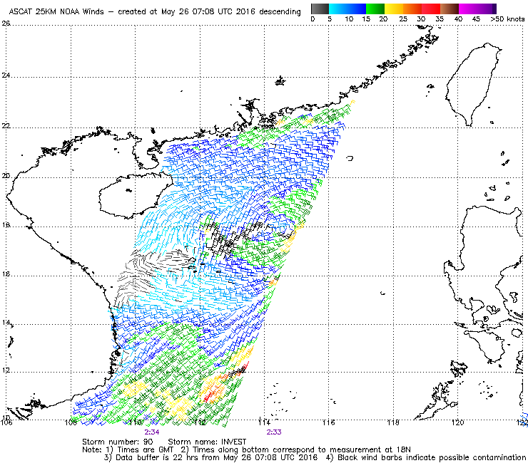
Figure 2 - Wind field analysis in the morning of May 26
圖 2 - 5 月 26 日早上的風場分析圖
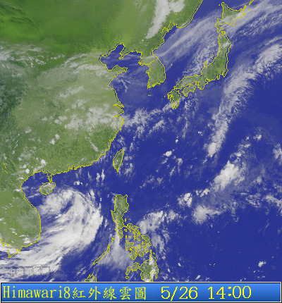
Figure 3 - The low pressure area was clearly spinning on May 26 as seen from this satellite image
圖 3 - 5 月 26 日的衛星雲圖,可見該低壓區螺旋性明顯
| Landfall and Dissipation 登陸及消散 |
By 10 am May 27, the HKO decided that widespread strong force winds would be unlikely, and it would consider issuing the Standby Signal in the next few hours. As a rainband swept across the territory near noon, many places saw a momentary surge in wind speed; about 5 to 10 mm of rainfall were recorded over most parts of the territory. Nevertheless, the Strong Wind Signal was eventually replaced by the #1 Standby Signal at 1:40 pm; 01W was situated about 220 km WSW of Hong Kong at that time.
Even though 01W made landfall later that afternoon at eastern Yangjiang, Guangdong, it was still getting closer to Hong Kong and winds actually picked up at some places; that at Chek Lap Kok, one of the eight reference stations, was perhaps the most notable as winds there reached strong force the first time after 5 pm that day. This means that four of the eight stations (i.e. together with Cheung Chau, Kai Tak and Sai Kung) registered strong force winds some time during the approach of 01W and that the Strong Wind Signal was officially justified, although this came after its cancellation.
As 01W experienced greater friction on land, its energy dissipated rapidly. It was the closest to Hong Kong near 8 pm that night, passing some 170 km west of the territory. Soon after, it weakened into a low pressure and the #1 Standby Signal was subsequently cancelled at 10:50 pm.
The impact of 01W on Hong Kong was minimal, but it drew in a southwesterly airstream afterwards, leading to some heavy showers on May 28. As an anticyclone assumed influence, local weather improved towards the end of the month.
至 27 日早上 10 時,天文台表示香港普遍吹強風的機會減低,並會於未來數小時考慮改發戒備信號。隨著一道雨帶於正午時份掠過本港,很多地方風勢短暫上升,廣泛地區錄得 5 至 10 毫米雨量。雖然如此,天文台仍於下午 1 時 40 分改發一號戒備信號,當時 01W 集結於香港西南偏西約 220 公里處。
01W 於當日下午較後時間登陸廣東陽江東部,但由於風暴仍在靠近香港,部分地區風勢不跌反升,其中或以赤鱲角最為觸目。赤鱲角是本港 8 個風速參考站之一,於 27 日下午 5 時首次吹強風,這代表 01W 靠近期間有 4 個參考站 (即與長洲、啟德及西貢) 風力曾達強風水平,亦正式表示三號信號達標,但達標之時三號信號已被取代。
由於陸上摩擦力較大,01W 登陸後能量快速喪失。它於當晚約 8 時最接近香港,於本港以西約 170 公里掠過。不久後,01W 減弱為一低壓區,而一號戒備信號亦於晚上 10 時 50 分取消。
01W 對本港的影響輕微,但它為華南沿岸引進一股西南氣流,香港於 28 日有大驟雨。隨著一個反氣旋增強,本港天氣於 5 月底改善。
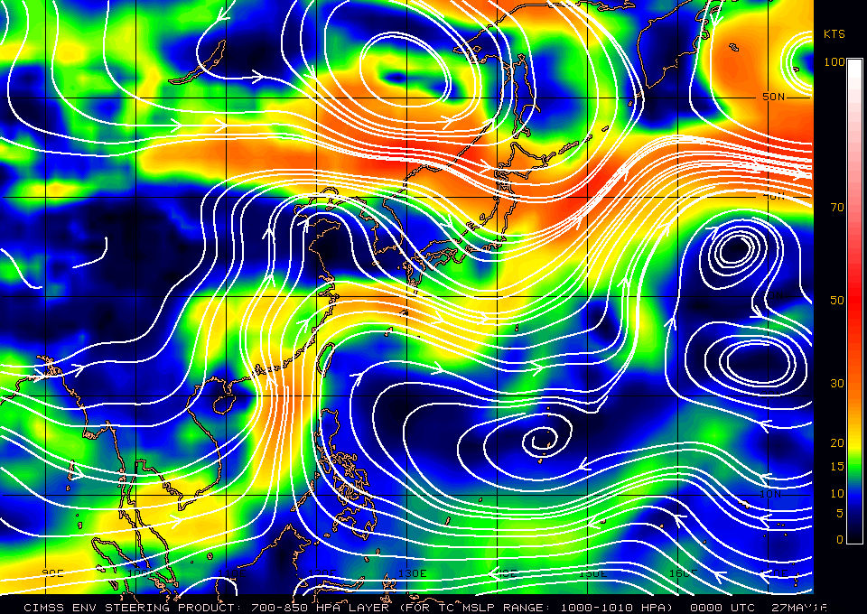
Figure 4 - Steering flow chart at 8 am May 27
圖 4 - 5 月 27 日早上 8 時之駛流圖

Figures 5 - Satellite image on May 27 showing 01W's approach to Yangjiang
圖 5 - 5 月 27 日的衛星雲圖,可見 01W 正靠近陽江
Figure 6 - Radar image near 01W's closest approach to Hong Kong (Credit to HKSON for archiving this image)
圖 6 - 01W 最接近香港時的雷達圖 (鳴謝 HKSON 將影像存檔)
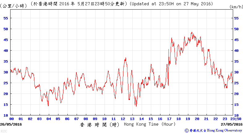
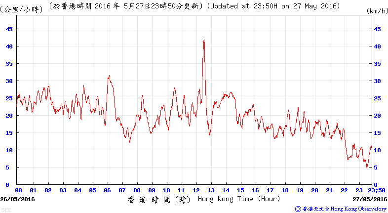
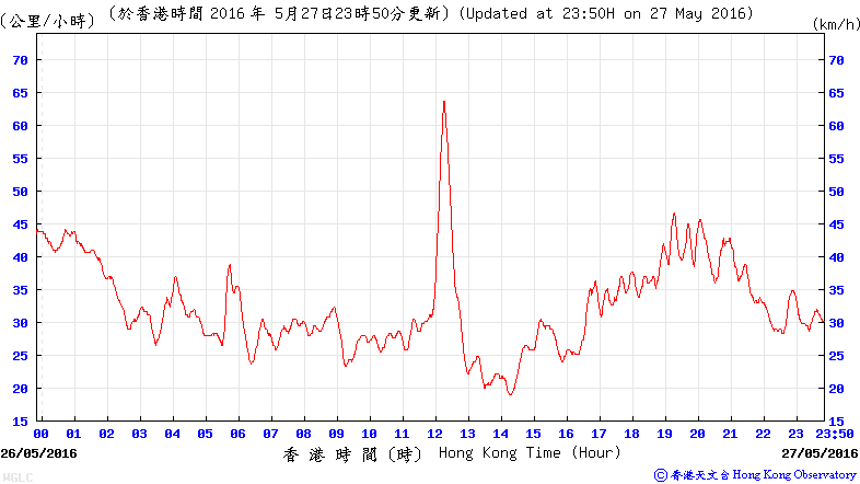
Figures 7a to 7c - Wind speed time series at Chek Lap Kok, Kai Tak and Waglan Island during 01W's approach
圖 7a 至 7c - 赤鱲角、啟德及橫瀾島於 01W 襲港時的風速時間序列圖
| Winds Recorded at Reference Stations 參考站所錄得的風速 |
| Station 風速站 |
Max. 10-min avg. wind speed 最高十分鐘平均風速 |
Beaufort classification 蒲福氏風級分類 |
| Chek Lap Kok 赤鱲角 | 48 km/h | STRONG 強風 |
| Cheung Chau 長洲 | 55 km/h | STRONG 強風 |
| Kai Tak 啟德 | 42 km/h | STRONG 強風 |
| Lau Fau Shan 流浮山 | 37 km/h | Fresh 清勁 |
| Sai Kung 西貢 | 45 km/h | STRONG 強風 |
| Sha Tin 沙田 | 20 km/h | Moderate 和緩 |
| Ta Kwu Ling 打鼓嶺 | 18 km/h | Moderate 和緩 |
| Tsing Yi (SHL) 青衣蜆殼油庫 | 37 km/h | Fresh 清勁 |
| Number of stations recording at least STRONG force (force 6 - 7) winds: | 4 |
| Number of stations recording at least GALE force (force 8 - 9) winds: | 0 |
| Number of stations recording at least STORM force (force 10 - 11) winds: | 0 |
| Number of stations recording HURRICANE force (force 12) winds: | 0 |
| 錄得 強風 (6 - 7 級) 或更高風速的站數: | 4 |
| 錄得 烈風 (8 - 9 級) 或更高風速的站數: | 0 |
| 錄得 暴風 (10 - 11 級) 或更高風速的站數: | 0 |
| 錄得 颶風 (12 級) 風速的站數: | 0 |
| Charts and Figures 各項數據 |
Table 1: Track data from HKWW:
表一 : 香港天氣觀測站之路徑資料
YYMMDDZZ Lat Long Wind |
Table 2: Maximum gust and hourly average wind speed recorded in Hong Kong from HKO:
表二 : 香港天文台公佈的各站最高每小時平均風力和陣風數據 (英文)
| Station | Maximum Gust |
Maximum Hourly Mean Wind |
||||||
|---|---|---|---|---|---|---|---|---|
Direction |
Speed (km/h) |
Date/Month |
Time |
Direction |
Speed (km/h) |
Date/Month |
Time |
|
| Bluff Head (Stanley) | E |
54 |
26/5 |
22:53 |
S |
31 |
27/5 |
20:00 |
SSE |
54 |
27/5 |
12:09 |
|||||
| Central Pier | E |
43 |
27/5 |
17:51 |
E |
31 |
27/5 |
00:00 |
| Cheung Chau | SE |
70 |
27/5 |
03:19 |
ESE |
40 |
27/5 |
12:00 |
| Cheung Chau Beach | ENE |
59 |
26/5 |
23:18 |
ENE |
41 |
27/5 |
03:00 |
| Green Island | S |
75 |
27/5 |
19:02 |
S |
51 |
27/5 |
19:00 |
| Hong Kong International Airport | S |
72 |
27/5 |
19:34 |
S |
45 |
27/5 |
20:00 |
| Kai Tak | ESE |
70 |
27/5 |
12:23 |
E |
27 |
26/5 |
23:00 |
| King's Park | S |
45 |
27/5 |
18:51 |
ESE |
19 |
27/5 |
12:00 |
| Lau Fau Shan | SE |
58 |
27/5 |
15:37 |
SE |
31 |
27/5 |
15:00 |
| Ngong Ping | SSW |
106 |
27/5 |
16:29 |
E |
72 |
27/5 |
02:00 |
| North Point | ENE |
49 |
27/5 |
00:43 |
E |
30 |
27/5 |
00:00 |
| Peng Chau | SSE |
51 |
27/5 |
18:08 |
E |
31 |
27/5 |
00:00 |
| Ping Chau | SE |
34 |
27/5 |
12:52 |
SE |
9 |
27/5 |
20:00 |
| Sai Kung | SSE |
58 |
27/5 |
12:34 |
ENE |
31 |
26/5 |
23:00 |
| Sha Chau | S |
79 |
27/5 |
17:54 |
S |
47 |
27/5 |
19:00 |
| Sha Lo Wan | SE |
65 |
27/5 |
15:27 |
SSE |
25 |
27/5 |
18:00 |
| Sha Tin | SE |
34 |
27/5 |
11:09 |
SE |
16 |
27/5 |
13:00 |
| Shek Kong | ENE |
52 |
26/5 |
22:33 |
E |
22 |
26/5 |
23:00 |
| Star Ferry (Kowloon) | ESE |
56 |
27/5 |
14:12 |
E |
27 |
27/5 |
03:00 |
| Ta Kwu Ling | E |
41 |
27/5 |
02:51 |
ENE |
13 |
27/5 |
05:00 |
| Tai Mei Tuk | SE |
59 |
27/5 |
12:45 |
E |
36 |
27/5 |
00:00 |
| Tai Mo Shan | SSW |
92 |
27/5 |
19:47 |
E |
59 |
26/5 |
22:00 |
| Tai Po Kau | E |
58 |
27/5 |
06:18 |
E |
30 |
27/5 |
00:00 |
| Tap Mun | SE |
68 |
27/5 |
12:37 |
ESE |
23 |
27/5 |
13:00 |
| Tate's Cairn | SE |
79 |
27/5 |
04:17 |
E |
52 |
26/5 |
23:00 |
| Tseung Kwan O | ESE |
41 |
27/5 |
12:23 |
SE |
12 |
27/5 |
12:00 |
| Tsing Yi Shell Oil Depot | SE |
49 |
27/5 |
18:20 |
SE |
34 |
27/5 |
19:00 |
| Tuen Mun Government Offices | SSE |
63 |
27/5 |
19:22 |
SSE |
25 |
27/5 |
18:00 |
SSE |
25 |
27/5 |
20:00 |
|||||
| Waglan Island | SSE |
72 |
27/5 |
12:10 |
E |
45 |
26/5 |
23:00 |
| Wetland Park | SE |
43 |
27/5 |
14:56 |
SSE |
20 |
27/5 |
15:00 |
| Wong Chuk Hang | E |
62 |
27/5 |
02:26 |
E |
25 |
27/5 |
03:00 |
Table 3: Rainfall (in millimetres) contributed by 01W from HKO (figures in brackets are based on incomplete hourly data):
表三 : 香港天文台公佈的各站雨量資料 (英文) (方括號內之數據由不完整之每小時資料擷取)
| Station | 26-May |
27-May |
Total Rainfall (mm) |
|
|---|---|---|---|---|
| Hong Kong Observatory (HKO) | 0.1 |
14.4 |
14.5 |
|
| Hong Kong International Airport (HKA) | 0.0 |
16.5 |
16.5 |
|
| Cheung Chau (CCH) | 0.0 |
17.5 |
17.5 |
|
| H23 | Aberdeen | 0.0 |
29.0 |
29.0 |
| N05 | Fanling | 0.0 |
8.5 |
8.5 |
| N13 | High Island | 0.5 |
21.0 |
21.5 |
| K04 | Jordan Valley | 2.0 |
10.5 |
12.5 |
| N06 | Kwai Chung | 1.5 |
16.0 |
17.5 |
| H12 | Mid Levels | 0.0 |
19.0 |
19.0 |
| SHA | Sha Tin | 0.5 |
9.5 |
10.0 |
| H19 | Shau Kei Wan | 0.0 |
10.5 |
10.5 |
| SEK | Shek Kong | 0.0 |
8.0 |
8.0 |
| K06 | So Uk Estate | 0.0 |
16.5 |
16.5 |
| R31 | Tai Mei Tuk | 1.0 |
6.5 |
7.5 |
| R21 | Tap Shek Kok | 0.0 |
9.0 |
9.0 |
| N17 | Tung Chung | 0.0 |
18.5 |
18.5 |
Last Accessed 最近訪問日期: Sun Sep 08 2024 12:39:39 HKT
Last Modified 最近修訂日期: Mon Jul 24 2023
