
TC Watch / 熱帶氣旋 > Selected TC Review / 重要熱帶氣旋回顧 > 201414W [Refresh 更新]
 201414W - Profile 檔案 201414W - Profile 檔案 |
(Issued on September 28, 2014)
(於 2014 年 9 月 28 日發出)
Brief profile of 14W | 14W 小檔案:
| JTWC number 聯合颱風警報中心 (JTWC) 號碼 | 14W |
| International number 國際編號 | ---- |
| Period of existence 生存時期 (JTWC) | 2014/09/07 14 HKT - 2014/09/08 14 HKT |
| Lifetime 壽命 (JTWC) | 1.00 day 日 |
| Maximum 1-minute wind (JTWC) JTWC 一分鐘平均最高中心風速 | 25 knots 節 (Tropical Depression 熱帶低氣壓) |
| Minimum pressure (JTWC) JTWC 最低氣壓 | 1003 hPa 百帕 |
| Highest TC signal by HKO (if applicable) 香港天文台發出最高熱帶氣旋警告信號 |
1 (Standby Signal 戒備信號) |
| Closest point of approach by HKO (if applicable) 香港天文台所示之最接近距離 (如適用) |
SW 360 km (real-time warning 實時報告 / TC report 熱帶氣旋報告) |
| Time of closest approach by HKO (if applicable) 香港天文台所示之最接近時間 (如適用) |
2014/09/08 03 HKT (real-time warning 實時報告) / 02 HKT (TC report 熱帶氣旋報告) |
| Lowest pressure recorded at HKO (if applicable) 香港天文台錄得的最低氣壓 (如適用) |
1006.0 hPa 百帕 (2014/09/07 14:38 HKT) |
TC signals for Hong Kong & Track 香港曾經生效的熱帶氣旋警告和路徑圖:
Table 表:
| Signal 信號 |
Date and time 日期和時間 |
Distance from HK 與香港的距離 |
Predicted movement 預測移動方向和速度 |
Max. 10-min winds 中心最高十分鐘平均風速 |
 |
2014/09/07 (SUN) 09:40 HKT | SSW 390 km | NW at 16 km/h | 45 km/h (25 knots, TD) |
 |
2014/09/08 (MON) 09:10 HKT | WSW 390 km | NW at 14 km/h | 55 km/h (30 knots, TD) |
Figure 圖:
(Track courtesy of Lorenzo. Data from HKO. 鳴謝 Lorenzo 提供路徑圖,資料取自天文台)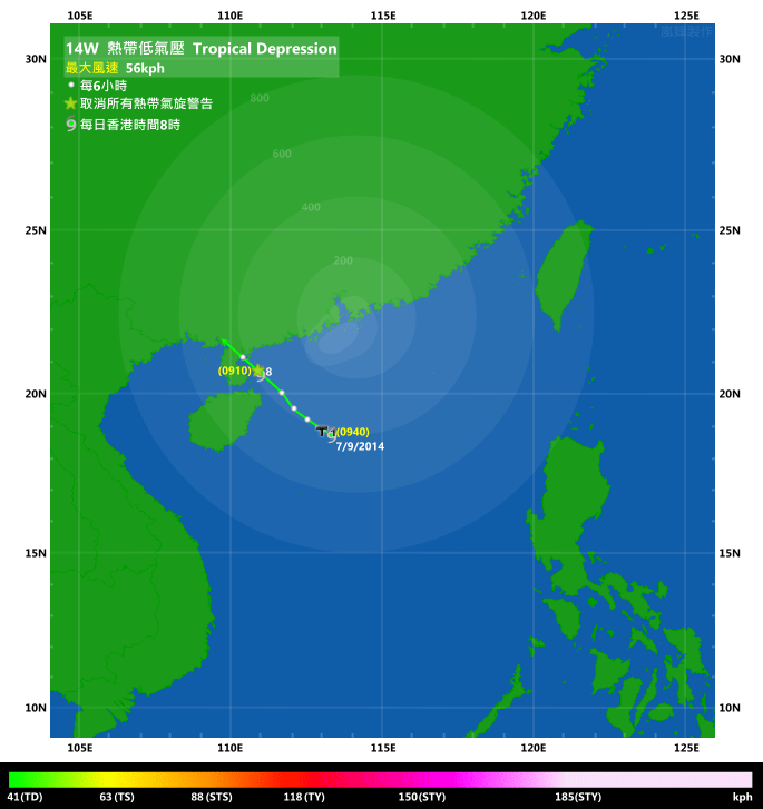
IR imagery animation 紅外線雲圖動畫:
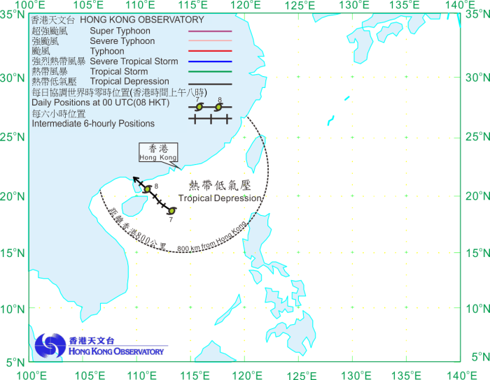
TC track from HKWW 本站的熱帶氣旋路徑圖:
TC track from HKO 天文台的熱帶氣旋路徑圖:
| Past HKWW Bulletins on 14W 本站有關 14W 的發佈 |
Please click here for bulletins on HAGIBIS. 請按這裡。
| Storm Formation and Development 氣旋形成和發展 |
Unless otherwise stated, all times below are in Hong Kong Standard Time (UTC+8)
除非特別註明,下文時間均為香港標準時間 (協調世界時加 8 小時)
14W is the first unnamed tropical cyclone to necessitate tropical cyclone warning signals since 2006. After a long period of inactivity, a blob of convections developed within South China Sea in early September. The JTWC issued a tropical cyclone formation alert at 2 pm September 6 as the system appeared to gather strength. Meanwhile, the HKO upgraded it into a tropical depression at 8 am the next day, when it was around 400 km SSW of Hong Kong. Due to the proximity of the system, the #1 Standby Signal was issued at 9:40 am. The JTWC also upgraded the system and gave it the number 14W.
14W was at that time situated to the SW of a subtropical ridge, and was therefore forecast to move NW. This implied that 14W would maintain a considerable distance from Hong Kong; together with its weak strength, widespread strong winds were not expected to affect the territory, and the Observatory mentioned in various reports that the chance of issuing higher signals was not high.
As the storm moved NW, its rainbands touched southern China. Locally, there were scattered showers but the amount of rainfall was low in general. Winds strengthened slightly on September 7, occasionally reaching strong force at offshore locations and on high ground.
14W 是自 2006 年以來首個未命名風暴令天文台發出熱帶氣旋警告信號。經過長時間的沉寂後,一團對流於 9 月初在南海發展。隨著該雲團有增強跡象,聯合颱風警報中心於 6 日下午 2 時對其發出熱帶氣旋形成警報。香港天文台於翌日早上 8 時將其升格為熱帶低氣壓,當時它為處本港西南偏南約 400 公里。由於該熱帶低氣壓較為接近本港,天文台於上午 9 時 40 分發出一號戒備信號。聯合颱風警報中心亦將系統升格,並給予編號 14W。
14W 當時處於副熱帶高壓脊的西南沿,並預料向西北移動,這意味著它會與本港保持距離;亦由於系統偏弱,當時估計本港普遍將不會吹強風,因此天文台於其熱帶氣旋警告中多次表示發出更高信號的機會不大。
隨著風暴向西北移動,其雨帶掠過華南沿岸,香港當天有幾陣驟雨,但雨勢不大。風勢於 7 日稍為增強,離岸及高地間中吹強風。
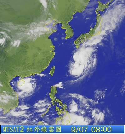
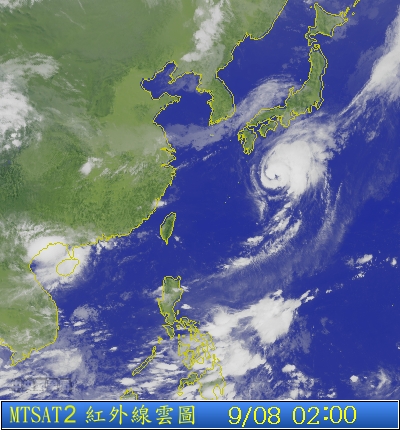
Figures 1a and 1b - Satellite images of 14W at formation (left) and at closest approach to Hong Kong (right)
圖 1a 及 1b - 14W 初形成 (左) 及最接近香港 (右) 時的衛星雲圖
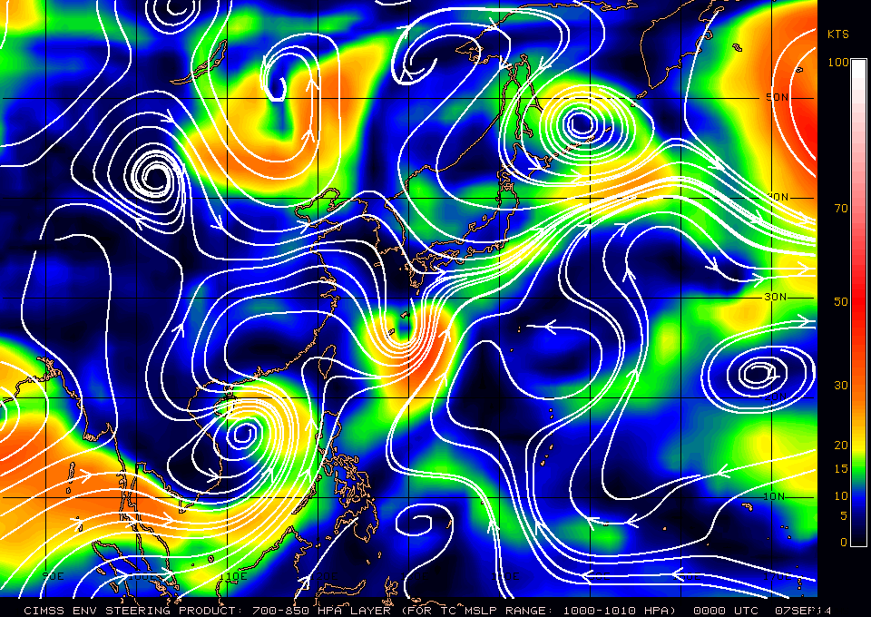
Figure 2 - Steering flow chart at 8 am September 7
圖 2 - 9 月 7 日上午 8 時之駛流圖
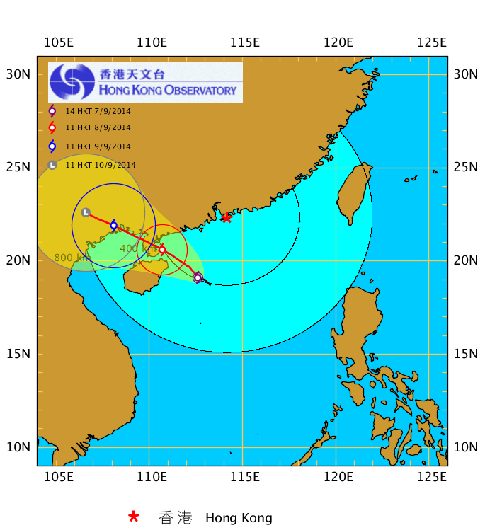
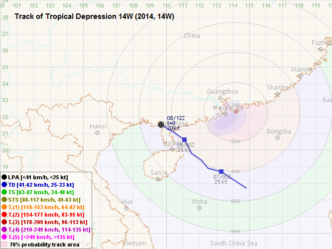
Figure 3 - HKO's track forecast on September 7
圖 3 - 9 月 7 日香港天文台之路徑預測
| Landfall and Dissipation 登陸及消散 |
14W turned more poleward in the latter part of September 7, and was the closest to Hong Kong at around 2-3 am September 8 when it was at 360 km to the SW. Showers were more frequent on September 8; more than 10 mm of rainfall was recorded at some parts of Hong Kong. Winds started to subside in the morning, and the Standby Signal was cancelled at 9:10 am.
Since 14W was close to landmass, its development was severely hindered. Convections were sheared to the west throughout its journey across northern South China Sea, leaving the low-level circulation centre partly exposed. According to the Chinese authorities, 14W made landfall near Zhanjiang at around 1:10 pm September 8, and was carrying force 7 winds near its centre. It turned WNW and soon dissipated in Guangxi.
It is worth mentioning that September 8 was the mid-autumn festival. In Hong Kong, clouds gradually dissipated in the latter part of September 8 as the influence of 14W diminished. The full moon was visible at times that night. As the subtropical ridge re-established, there were sunny periods in the following day.
14W 於 9 月 7 日後段的移向較為偏北,並於 8 日早上 2 至 3 時最接近香港,當時它處於本港西南約 360 公里。驟雨於 8 日較為頻密,本港部分地區當天錄得超過 10 毫米雨量。由於風勢於早上逐漸緩和,天文台於上午 9 時 10 分取消一號戒備信號。
由於 14W 靠近陸地,其發展受嚴重限制。14W 於南海前進期間,其對流一直被切離至系統西面,令低層環流中心部分外露。中國有關方面表示,14W 於 8 日下午約 1 時 10 分登陸湛江一帶,中心附近風力達 7 級。登陸後風暴向西北偏西移動,不久後於廣西消散。
值得一提的是 9 月 8 日為中秋節。香港方面,隨著 14W 的影響漸退,雲層於 8 日後段轉薄,晚間更可見滿月。副熱帶高壓脊隨即重新建立,翌日本港部分時間有陽光。


Figures 4a and 4b - 14W's outer rainbands affected Hong Kong on September 7 and 8
圖 4a 及 4b - 14W 的外圍雨帶於 9 月 7 及 8 日影響香港
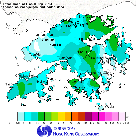
Figure 5 - Total rainfall chart for September 8
圖 5 - 9 月 8 日之總雨量圖

Figure 6 - 14W about to make landfall near Zhanjiang
圖 6 - 14W 即將於湛江一帶登陸
| Winds Recorded at Reference Stations 參考站所錄得的風速 |
(Except for special cases, this section is not available for cyclones that only necessitated the Standby Signal 除非特別情況,否則此部只當氣旋令天文台發出三號或更高信號時提供)
| Charts and Figures 各項數據 |
Table 1: Track data from HKWW:
表一 : 香港天氣觀測站之路徑資料
YYMMDDZZ Lat Long Wind |
Table 2: Maximum gust and hourly average wind speed recorded in Hong Kong from HKO:
表二 : 香港天文台公佈的各站最高每小時平均風力和陣風數據
| Maximum Gust | Maximum Hourly Mean Wind | |||||||
|---|---|---|---|---|---|---|---|---|
| Station | Direction | Speed (km/h) | Date/Month | Time | Direction | Speed (km/h) | Date/Month | Time |
| Bluff Head (Stanley) | ESE |
58 |
7/9 |
16:46 |
ESE |
27 |
7/9 |
17:00 |
| Central Pier | E |
43 |
7/9 |
17:06 |
E |
31 |
7/9 |
16:00 |
E |
43 |
7/9 |
17:16 |
|||||
| Cheung Chau | ESE |
58 |
7/9 |
20:22 |
E |
36 |
7/9 |
17:00 |
| Cheung Chau Beach | ENE |
59 |
7/9 |
17:09 |
E |
38 |
7/9 |
17:00 |
| Green Island | NE |
58 |
7/9 |
20:54 |
NE |
43 |
7/9 |
16:00 |
| Hong Kong International Airport | ESE |
49 |
7/9 |
16:22 |
ESE |
34 |
7/9 |
16:00 |
| Kai Tak | ESE |
51 |
7/9 |
13:02 |
E |
23 |
7/9 |
13:00 |
E |
23 |
7/9 |
14:00 |
|||||
| King's Park | ESE |
41 |
7/9 |
16:59 |
SE |
16 |
7/9 |
16:00 |
ESE |
16 |
7/9 |
20:00 |
|||||
ESE |
16 |
7/9 |
21:00 |
|||||
| Lau Fau Shan | ENE |
49 |
7/9 |
14:25 |
ENE |
30 |
7/9 |
15:00 |
| Ngong Ping | E |
79 |
7/9 |
18:36 |
E |
63 |
7/9 |
19:00 |
| North Point | E |
43 |
7/9 |
11:14 |
E |
25 |
7/9 |
16:00 |
E |
43 |
7/9 |
15:48 |
|||||
| Peng Chau | E |
47 |
7/9 |
15:16 |
E |
36 |
7/9 |
16:00 |
| Sai Kung | ENE |
38 |
7/9 |
15:50 |
ENE |
25 |
7/9 |
12:00 |
| Sha Chau | SE |
41 |
7/9 |
17:46 |
SE |
30 |
7/9 |
16:00 |
| Sha Lo Wan | E |
47 |
7/9 |
16:20 |
E |
25 |
7/9 |
17:00 |
| Sha Tin | E |
31 |
7/9 |
14:55 |
E |
13 |
7/9 |
14:00 |
E |
13 |
7/9 |
15:00 |
|||||
| Shek Kong | E |
36 |
7/9 |
16:36 |
E |
19 |
7/9 |
16:00 |
| Star Ferry (Kowloon) | E |
49 |
7/9 |
17:02 |
E |
31 |
7/9 |
17:00 |
| Ta Kwu Ling | E |
34 |
7/9 |
18:32 |
E |
14 |
7/9 |
17:00 |
| Tai Mei Tuk | E |
47 |
7/9 |
15:54 |
E |
31 |
7/9 |
15:00 |
E |
47 |
7/9 |
17:09 |
|||||
| Tai Mo Shan | ESE |
75 |
7/9 |
19:31 |
E |
52 |
7/9 |
20:00 |
| Tai Po Kau | E |
40 |
7/9 |
16:06 |
E |
27 |
7/9 |
17:00 |
| Tap Mun | SE |
34 |
7/9 |
23:46 |
SE |
22 |
8/9 |
09:00 |
| Tate's Cairn | ESE |
63 |
7/9 |
19:52 |
E |
40 |
7/9 |
20:00 |
| Tseung Kwan O | ENE |
40 |
7/9 |
15:39 |
ENE |
14 |
7/9 |
14:00 |
| Tsing Yi Shell Oil Depot | - |
36 |
7/9 |
12:50 |
- |
16 |
7/9 |
16:00 |
| Tuen Mun Government Offices | ESE |
40 |
7/9 |
15:16 |
SE |
19 |
7/9 |
16:00 |
| Waglan Island | SE |
67 |
7/9 |
16:36 |
ENE |
41 |
7/9 |
12:00 |
| Wetland Park | E |
34 |
7/9 |
14:50 |
E |
16 |
7/9 |
15:00 |
| Wong Chuk Hang | SE |
43 |
7/9 |
17:02 |
E |
22 |
7/9 |
13:00 |
Table 3: Rainfall (in millimetres) contributed by 14W from HKO (figures in brackets are based on incomplete hourly data):
表三 : 香港天文台公佈的各站雨量資料 (方括號內之數據由不完整之每小時資料擷取)
| Station | 7-Sep |
8-Sep |
Total Rainfall (mm) |
|
|---|---|---|---|---|
| Hong Kong Observatory | 0.6 |
3.0 |
3.6 |
|
| Hong Kong International Airport (HKA) | 0.2 |
2.1 |
2.3 |
|
| Cheung Chau (CCH) | 4.5 |
4.0 |
8.5 |
|
| H23 | Aberdeen | 1.0 |
[3.5] |
[4.5] |
| N05 | Fanling | [0.5] |
[4.0] |
[4.5] |
| N13 | High Island | 0.0 |
[1.0] |
[1.0] |
| K04 | Jordan Valley | 3.0 |
[11.0] |
[14.0] |
| N06 | Kwai Chung | 6.0 |
[7.5] |
[13.5] |
| H12 | Mid Levels | 1.5 |
[6.0] |
[7.5] |
| SHA | Sha Tin | 4.0 |
14.0 |
18.0 |
| H19 | Shau Kei Wan | 0.5 |
[12.0] |
[12.5] |
| SEK | Shek Kong | 3.0 |
4.5 |
7.5 |
| K06 | So Uk Estate | 3.0 |
[5.0] |
[8.0] |
| R31 | Tai Mei Tuk | 4.0 |
8.0 |
12.0 |
| R21 | Tap Shek Kok | 0.5 |
1.0 |
1.5 |
| N17 | Tung Chung | 1.5 |
[9.5] |
[11.0] |
| R27 | Yuen Long | 2.0 |
1.0 |
3.0 |
Last Accessed 最近訪問日期: Sun Sep 08 2024 12:45:51 HKT
Last Modified 最近修訂日期: Mon Jul 24 2023
