
TC Watch / 熱帶氣旋 > Selected TC Review / 重要熱帶氣旋回顧 > 201407W (HAGIBIS 海貝思) [Refresh 更新]
 201407W (HAGIBIS 海貝思) - Profile 檔案 201407W (HAGIBIS 海貝思) - Profile 檔案 |
(First draft issued on June 26, 2014; final version issued on July 2, 2014)
(初稿於 2014 年 6 月 26 日發出,最後版本於 2014 年 7 月 2 日上載)
Brief profile of HAGIBIS 海貝思小檔案:
| JTWC number 聯合颱風警報中心 (JTWC) 號碼 | 07W |
| International number 國際編號 | 1407 |
| Period of existence 生存時期 (JTWC) | 2014/06/14 02 HKT - 2014/06/18 02 HKT |
| Lifetime 壽命 (JTWC) | 4.00 days 日 |
| Maximum 1-minute wind (JTWC) JTWC 一分鐘平均最高中心風速 | 45 knots 節 (Tropical Storm 熱帶風暴) |
| Minimum pressure (JTWC) JTWC 最低氣壓 | 989 hPa 百帕 |
| Highest TC signal by HKO (if applicable) 香港天文台發出最高熱帶氣旋警告信號 |
1 (Standby Signal 戒備信號) |
| Closest point of approach by HKO (if applicable) 香港天文台所示之最接近距離 (如適用) |
E 260 km (real-time warning 實時報告 / TC report 熱帶氣旋報告) |
| Time of closest approach by HKO (if applicable) 香港天文台所示之最接近時間 (如適用) |
Around 約 2014/06/15 10 HKT (real-time warning 實時報告) / 09 HKT (TC report 熱帶氣旋報告) |
| Lowest pressure recorded at HKO (if applicable) 香港天文台錄得的最低氣壓 (如適用) |
1001.2 hPa 百帕 (2014/06/15 04:53 HKT) |
TC signals for Hong Kong & Track 香港曾經生效的熱帶氣旋警告和路徑圖:
Table 表:
| Signal 信號 |
Date and time 日期和時間 |
Distance from HK 與香港的距離 |
Predicted movement 預測移動方向和速度 |
Max. 10-min winds 中心最高十分鐘平均風速 |
 |
2014/06/14 (SAT) 17:40 HKT | ESE 310 km | N/NNW slowly | 65 km/h (35 knots, TS) |
 |
2014/06/15 (SUN) 13:20 HKT | E 260 km | N at 10 km/h | 65 km/h (35 knots, TS) |
Figure 圖:
(Track courtesy of Lorenzo. Data from HKO. 鳴謝 Lorenzo 提供路徑圖,資料取自天文台)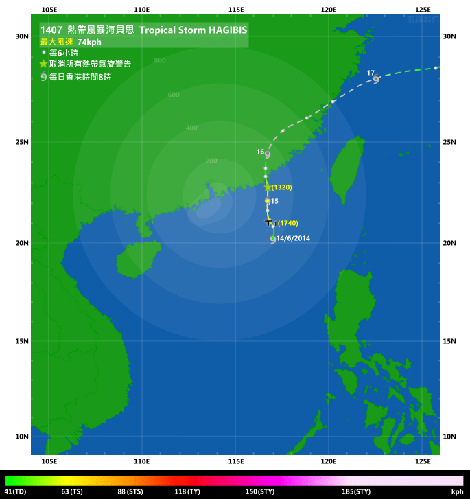
IR imagery animation 紅外線雲圖動畫:
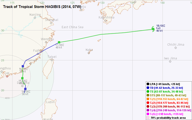
TC track from HKWW 本站的熱帶氣旋路徑圖:
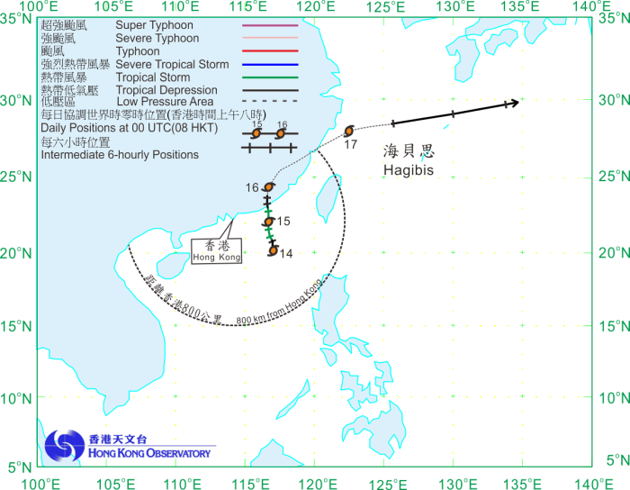
TC track from HKO 天文台的熱帶氣旋路徑圖:
| Past HKWW Bulletins on HAGIBIS 本站有關海貝思的發佈 |
Please click here for bulletins on HAGIBIS. 請按這裡。
| Storm Formation and Development 氣旋形成和發展 |
Unless otherwise stated, all times below are in Hong Kong Standard Time (UTC+8)
除非特別註明,下文時間均為香港標準時間 (協調世界時加 8 小時)
An area of low pressure developed in the South China Sea in the middle of June. The JTWC issued a tropical cyclone formation alert for the system at 8 am June 14, and upgraded the system into tropical storm 07W just 6 hours later. The JMA also made the upgrade at the same time and assigned the name HAGIBIS to it. This name was provided by the Philippines, meaning "fast". The storm's appearance improved appreciably during that day, and an ASCAT scan at 9 am that morning indicated gale force winds near the storm.
As for the HKO, it upgraded the low pressure area into a tropical depression at 10 am June 14. It is interesting to note that the HKO used Hong Kong as the reference location when reporting the position of the storm, despite no tropical cyclone signal was in force at that time. At its formation, the tropical depression was only 380 km SE of the territory.
The subtropical ridge was firmly established to the east of the storm at that time, extending well into the Pacific Ocean. HAGIBIS was therefore generally expected to move north towards southeastern China. Numerical models were in good agreement.
Within the next 12 hours, HAGIBIS gradually developed and showed signs of moving NNW instead of N, edging closer to the territory. The HKO issued the #1 Standby Signal at 5:40 pm and upgraded HAGIBIS into a tropical storm. Although it was calm in Hong Kong, northerly winds were expected to prevail later, and there would be occasional showers. Partly affected by HAGIBIS, a continental airstream was influencing Hong Kong on June 13 and 14, resulting in very dry and hot weather. The relative humidity at the HKO dropped to below 40% on June 13 which necessitated a rare red fire danger warning in this time of the year. The maximum air temperature of 33.5 degrees on June 14 was also the highest so far this year.
HAGIBIS resumed its northerly motion on June 15. Its outer rainbands swept through parts of Hong Kong; meanwhile, winds backed from NE to N and then NW, but remained generally light to moderate. At a distance of 260 km, the storm was closest to Hong Kong that morning. The HKO cancelled the Standby Signal at 1:20 pm when HAGIBIS had clearly crossed Hong Kong's latitude. It was also evident from satellite images that intense convections were diminishing as the storm neared shore.
一個低壓區於 6 月中旬在南海發展。聯合颱風警報中心於 6 月 14 日上午 8 時對其發出熱帶氣旋形成警報,並於 6 小時後將其升格為熱帶風暴 07W。日本氣象廳同時作出升格,並將其命名為海貝思。此名稱由菲律賓提供,解作「快捷」。風暴的外型於當天明顯轉佳,而 ASCAT 風場掃描圖顯示於當天早上 9 時風暴中心附近有烈風區。
香港天文台於 14 日上午 10 時將該低壓區升格為熱帶低氣壓。比較有趣的是天文台於尚未發出熱帶氣旋警告信號時已經以香港作為報導風暴位置的參考地點;該熱帶低氣壓形成時只處於香港東南約 380 公里。
當時,副熱帶高壓脊穩定盤據於海貝思以東,並深入太平洋,因此一般預計海貝思將大致向北移動,趨向中國東南部。數值模式預報結果亦相當一致。
海貝思於隨後的 12 小時逐漸增強,而路徑稍為偏西,開始向西北偏北移動並進一步接近本港。天文台於 14 日下午 5 時 40 分發出一號戒備信號,並升格海貝思為熱帶風暴。本地情況大致平靜,但預料稍後會開始吹北風,並間有驟雨。海貝思的位置令香港於 13 及 14 日受大陸氣流影響,天氣非常乾燥且悶熱。天文台於 13 日曾錄得相對濕度低於百分之 40,罕見地於 6 月發出紅色火災危險警告。於 14 日所錄得的 33.5 度亦是本年至今的最高氣溫。
海貝思於 15 日轉回向北移,其外圍雨帶掃過本港部分地區。與此同時,香港風向由東北逆轉至偏北及西北,但風速一般只為輕微至和緩。海貝思於當天早上最接近香港,兩者距離約為 260 公里。當海貝思橫過香港緯度後,天文台於下午 1 時 20 分取消一號戒備信號,而從衛星雲圖亦可見風暴靠岸時其深層對流逐漸減少。
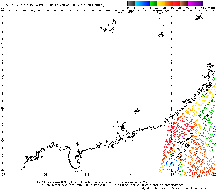
Figure 1 - Wind field of HAGIBIS at its formation
圖 1 - 海貝思初形成時之風場圖
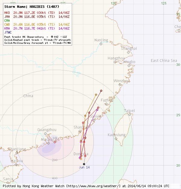
Figure 2 - Forecast tracks from different agencies on June 14
圖 2 - 6 月 14 日各站預測路徑圖
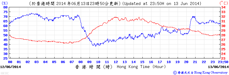
Figure 3 - The relative humidity at the HKO dropped to below 40% on June 13
圖 3 - 香港天文台之相對濕度於 6 月 13 日下降至百分之 40 以下

Figure 4 - Satellite image of HAGIBIS near its closest approach to Hong Kong
圖 4 - 海貝思於最接近香港時之衛星雲圖

Figure 5 - Steering flow chart at 8 am June 15
圖 5 - 6 月 15 日上午 8 時之駛流場圖
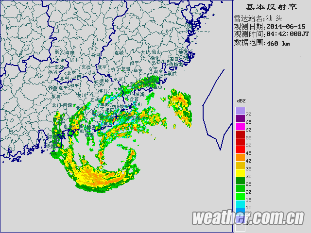
Figure 6 - HAGIBIS's outer rainbands affecting parts of Hong Kong
圖 6 - 海貝思的外圍雨帶正影響香港部分地區
| Landfall, Recurvature and Regeneration 登陸、轉向及重生 |
HAGIBIS made landfall near Shantou at around 4:50 pm, just a few hours after the cancellation of the Standby Signal. From radar, the storm could be seen to maintain decent structure at landfall although satellite images might suggest otherwise. Agencies gradually stopped issuing bulletins for the system as its structure deteriorated several hours after landfall. The rainbands associated with HAGIBIS moved into Fujian province as the system recurved along the northwestern periphery of the subtropical ridge. Widespread flooding was reported in that region; direct economic losses were estimated at 675 million yuan according to Chinese officials.
After spending more than a day inland, HAGIBIS's convective patches entered East China Sea in the early hours of June 17. Wind field analysis revealed gales near the storm, but the low-level circulation centre seemed somehow distorted. The JTWC re-issued bulletins for HAGIBIS at 2 am, while the JMA resumed warning bulletins at 11 am. By that time, HAGIBIS had already travelled to the northern periphery of the subtropical ridge. Under the influence from the ridge and the westerlies, it was speeding eastwards in excess of 50 km/h.
Sea temperatures at that region were sub-optimal. Together with strong vertical wind shear, HAGIBIS underwent extratropical transition and became a temperate cyclone on June 18 in seas south of Japan.
取消戒備信號數小時後,海貝思於下午約 4 時 50 分登陸汕頭一帶。雖然從衛星雲圖可見風暴逐漸減弱,但雷達圖像仍顯示其結構良好。隨著登陸後結構轉差,各氣象機構逐漸停止對海貝思的發佈。海貝思登陸後沿副高西北部向東北轉向,與其相關的雨帶進入福建省,當地多處出現水浸,中國當局估計海貝思所造成的直接經濟損失達 6.75 億人民幣。
橫過內陸超過一天後,海貝思的對流帶於 6 月 17 日早段進入東海。風場圖顯示風暴周圍有烈風,但低層環流中心已被擾亂。聯合颱風警報中心於凌晨 2 時再次為海貝思作出發佈,而日本氣象廳則於上午 11 時重新發佈。海貝思當時已到達副高北沿,受該脊及西風帶共同影響,海貝思以每小時超過 50 公里的高速向東移動。
由於當地海溫較低且垂直風切變強勁,海貝思很快便開始溫帶氣旋轉化,過程於 18 日在日本以南海域完成。
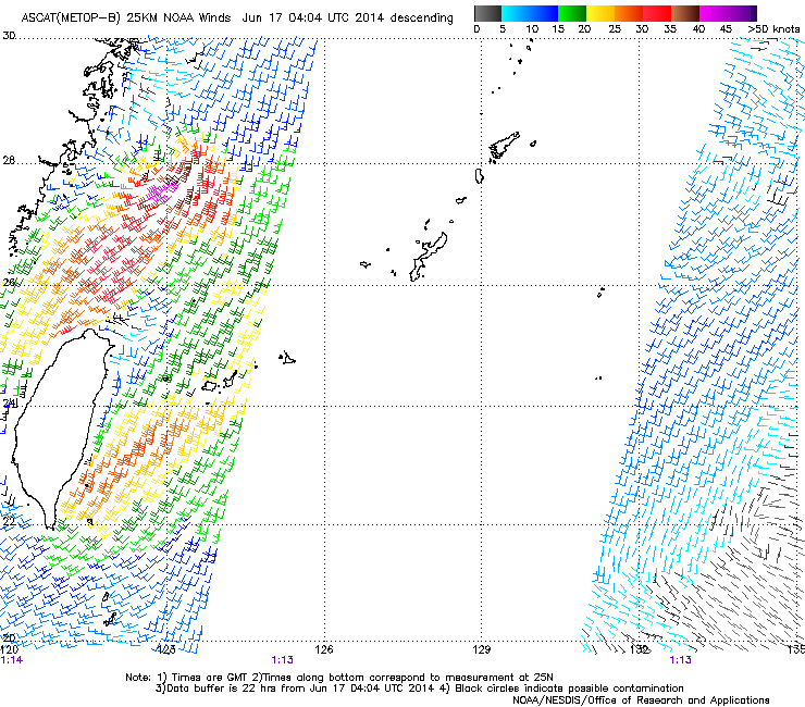
Figure 7 - Wind field analysis showing gale force winds near HAGIBIS's centre, but with an ill-defined low-level circulation centre
圖 7 - 風場分析顯示海貝思中心一帶吹烈風,但其低層環流中心並不清晰


Figures 8a and 8b - Satellite images showing HAGIBIS crossing Fujian (left) and emerging into East China Sea (right)
圖 8a 及 8b - 衛星圖像顯示海貝思橫過福建 (左圖) 並進入東海 (右圖)
| Winds Recorded at Reference Stations 參考站所錄得的風速 |
(Except for special cases, this section is not available for cyclones that only necessitated the Standby Signal 除非特別情況,否則此部只當氣旋令天文台發出三號或更高信號時提供)
| Charts and Figures 各項數據 |
Table 1: Track data from HKWW:
表一 : 香港天氣觀測站之路徑資料
YYMMDDZZ Lat Long Wind |
Table 2: Maximum gust and hourly average wind speed recorded in Hong Kong from HKO:
表二 : 香港天文台公佈的各站最高每小時平均風力和陣風數據
| Maximum Gust | Maximum Hourly Mean Wind | |||||||
|---|---|---|---|---|---|---|---|---|
| Station | Direction | Speed (km/h) | Date/Month | Time | Direction | Speed (km/h) | Date/Month | Time |
Bluff Head (Stanley) |
NNE |
36 |
14/6 |
21:07 |
E |
22 |
14/6 |
18:00 |
Central Pier |
W |
30 |
15/6 |
11:02 |
E |
22 |
14/6 |
18:00 |
|
WNW |
30 |
15/6 |
12:40 |
|
|
|
|
Cheung Chau |
ESE |
47 |
14/6 |
17:41 |
ESE |
30 |
14/6 |
18:00 |
Cheung Chau Beach |
E |
34 |
14/6 |
17:40 |
E |
27 |
14/6 |
18:00 |
Green Island |
NE |
49 |
14/6 |
17:49 |
NE |
34 |
14/6 |
18:00 |
Hong Kong International Airport |
ESE |
36 |
14/6 |
18:11 |
E |
25 |
14/6 |
19:00 |
Kai Tak |
NE |
31 |
14/6 |
20:49 |
E |
19 |
14/6 |
18:00 |
King's Park |
NE |
30 |
14/6 |
22:55 |
SE |
14 |
14/6 |
18:00 |
Lau Fau Shan |
N |
34 |
15/6 |
07:54 |
NNW |
20 |
14/6 |
18:00 |
Ngong Ping |
NE |
52 |
15/6 |
10:12 |
ENE |
27 |
15/6 |
11:00 |
North Point |
W |
31 |
15/6 |
10:43 |
E |
19 |
14/6 |
18:00 |
|
|
|
|
|
WSW |
19 |
15/6 |
11:00 |
Peng Chau |
NW |
47 |
15/6 |
10:34 |
E |
25 |
14/6 |
19:00 |
Ping Chau |
NW |
23 |
15/6 |
06:22 |
NW |
7 |
15/6 |
07:00 |
Sai Kung |
N |
31 |
15/6 |
00:15 |
E |
13 |
14/6 |
18:00 |
|
|
|
|
|
N |
13 |
15/6 |
01:00 |
Sha Chau |
N |
47 |
15/6 |
10:07 |
N |
23 |
15/6 |
11:00 |
Sha Lo Wan |
ESE |
30 |
15/6 |
11:51 |
SW |
13 |
15/6 |
03:00 |
Sha Tin |
ESE |
20 |
14/6 |
18:16 |
SE |
9 |
14/6 |
18:00 |
N |
20 |
15/6 |
10:13 |
|
|
|
|
|
NE |
20 |
15/6 |
10:19 |
|
|
|
|
|
Shek Kong |
E |
27 |
14/6 |
17:58 |
E |
13 |
14/6 |
18:00 |
Star Ferry (Kowloon) |
W |
30 |
15/6 |
10:43 |
W |
23 |
15/6 |
11:00 |
W |
30 |
15/6 |
10:44 |
|
|
|
|
|
Ta Kwu Ling |
E |
27 |
14/6 |
17:46 |
E |
13 |
14/6 |
18:00 |
ESE |
27 |
14/6 |
18:40 |
|
|
|
|
|
Tai Mei Tuk |
WNW |
40 |
15/6 |
09:10 |
W |
22 |
15/6 |
10:00 |
Tai Mo Shan |
NNW |
63 |
14/6 |
21:50 |
NNW |
40 |
15/6 |
08:00 |
Tai Po Kau |
WNW |
25 |
15/6 |
11:57 |
E |
16 |
14/6 |
18:00 |
Tap Mun |
WNW |
38 |
15/6 |
10:11 |
W |
22 |
15/6 |
11:00 |
Tate's Cairn |
N |
51 |
14/6 |
20:39 |
ENE |
34 |
14/6 |
21:00 |
|
N |
51 |
14/6 |
20:44 |
|
|
|
|
Tseung Kwan O |
N |
23 |
15/6 |
08:08 |
ENE |
7 |
14/6 |
18:00 |
|
|
|
|
E |
7 |
14/6 |
19:00 |
|
|
|
|
|
ENE |
7 |
14/6 |
21:00 |
|
Tsing Yi Shell Oil Depot |
- |
23 |
14/6 |
17:40 |
- |
14 |
14/6 |
18:00 |
Tuen Mun Government Offices |
NNE |
27 |
15/6 |
10:15 |
NNE |
9 |
15/6 |
11:00 |
Waglan Island |
E |
47 |
14/6 |
18:30 |
E |
36 |
14/6 |
19:00 |
Wetland Park |
NW |
23 |
15/6 |
10:01 |
NW |
13 |
15/6 |
11:00 |
Wong Chuk Hang |
N |
30 |
15/6 |
09:55 |
E |
12 |
14/6 |
18:00 |
Table 3: Rainfall (in millimetres) contributed by HAGIBIS from HKO (figures in brackets are based on incomplete hourly data):
表三 : 香港天文台公佈的各站雨量資料 (方括號內之數據由不完整之每小時資料擷取)
| Station | 14-Jun |
15-Jun |
Total Rainfall (mm) |
|
|---|---|---|---|---|
| Hong Kong Observatory | Trace |
9.9 |
9.9 |
|
| Hong Kong International Airport (HKA) | 0.0 |
6.6 |
6.6 |
|
| Cheung Chau (CCH) | 0.0 |
11.0 |
11.0 |
|
| H23 | Aberdeen | 0.5 |
9.0 |
9.5 |
| N05 | Fanling | 0.0 |
8.0 |
8.0 |
| N13 | High Island | 0.0 |
12.5 |
12.5 |
| K04 | Jordan Valley | 0.0 |
11.5 |
11.5 |
| N06 | Kwai Chung | 0.0 |
7.5 |
7.5 |
| H12 | Mid Levels | 0.0 |
8.0 |
8.0 |
| N09 | Sha Tin | 0.0 |
6.5 |
6.5 |
| H19 | Shau Kei Wan | 0.0 |
27.0 |
27.0 |
| SEK | Shek Kong | 0.0 |
5.5 |
5.5 |
| K06 | So Uk Estate | 0.0 |
7.5 |
7.5 |
| R31 | Tai Mei Tuk | 0.0 |
7.0 |
7.0 |
| R21 | Tap Shek Kok | 0.0 |
9.0 |
9.0 |
| N17 | Tung Chung | 0.0 |
4.0 |
4.0 |
| R27 | Yuen Long | 0.0 |
4.5 |
4.5 |
Last Accessed 最近訪問日期: Sun Sep 08 2024 12:39:49 HKT
Last Modified 最近修訂日期: Mon Jul 24 2023
