
TC Watch / 熱帶氣旋 > Selected TC Review / 重要熱帶氣旋回顧 > 201328W (LEKIMA 利奇馬) [Refresh 更新]
 201328W (LEKIMA 利奇馬) - Profile 檔案 201328W (LEKIMA 利奇馬) - Profile 檔案 |
(Issued on December 8, 2013)
(於 2013 年 12 月 8 日發出)
Brief profile of LEKIMA 利奇馬小檔案:
| JTWC number 聯合颱風警報中心 (JTWC) 號碼 | 28W |
| International number 國際編號 | 1328 |
| Period of existence 生存時期 (JTWC) | 2013/10/20 20 HKT - 2013/10/26 14 HKT |
| Lifetime 壽命 (JTWC) | 5.75 days 日 |
| Maximum 1-minute wind (JTWC) JTWC 一分鐘平均最高中心風速 | 140 knots 節 (Category 5 Super Typhoon 五級超級颱風) |
| Minimum pressure (JTWC) JTWC 最低氣壓 | 918 hPa 百帕 |
| Highest TC signal by HKO (if applicable) 香港天文台發出最高熱帶氣旋警告信號 |
N/A 不適用 |
| Closest point of approach by HKO (if applicable) 香港天文台所示之最接近距離 (如適用) |
N/A 不適用 |
| Time of closest approach by HKO (if applicable) 香港天文台所示之最接近時間 (如適用) |
N/A 不適用 |
| Lowest pressure recorded at HKO (if applicable) 香港天文台錄得的最低氣壓 (如適用) |
N/A 不適用 |
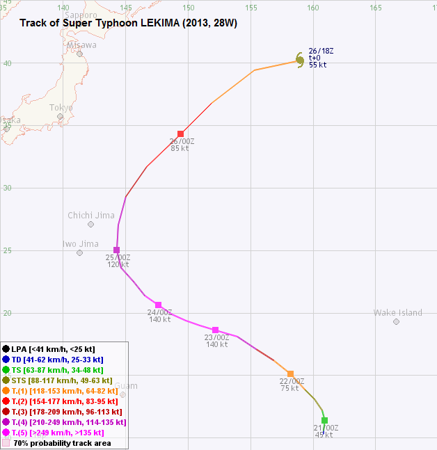
TC track from HKWW 本站的熱帶氣旋路徑圖:
| Past HKWW Bulletins on LEKIMA 本站有關利奇馬的發佈 |
Please click here for bulletins on LEKIMA. 請按這裡。
| Storm Summary 氣旋摘要 |
Unless otherwise stated, all times below are in Hong Kong Standard Time (UTC+8)
除非特別註明,下文時間均為香港標準時間 (協調世界時加 8 小時)
At the time of writing, LEKIMA is the storm formed at the most eastern location within this basin in 2013. The disturbance was quite disorganized at formation, and because of its low latitude it was moving slowly at first since it was too far to be influenced by the subtropical ridge to the north. It attained tropical depression status (28W) at 8 pm on October 20, and was drifting north slowly at that time. Due to the very high ocean heat content there, 28W gained intensity quickly and became a tropical storm on October 21. The JMA named it LEKIMA, which was provided by Vietnam and is the name of a tree whose fruit has one seed and yellow pulp.
Due to the dominance of the subtropical ridge, LEKIMA was expected to follow the traditional recurving track. The strong subtropical ridge also meant LEKIMA would be moving rather quickly. In fact LEKIMA's speed averaged above 25 km/h before recurving, and accelerated to beyond 50 km/h after that.
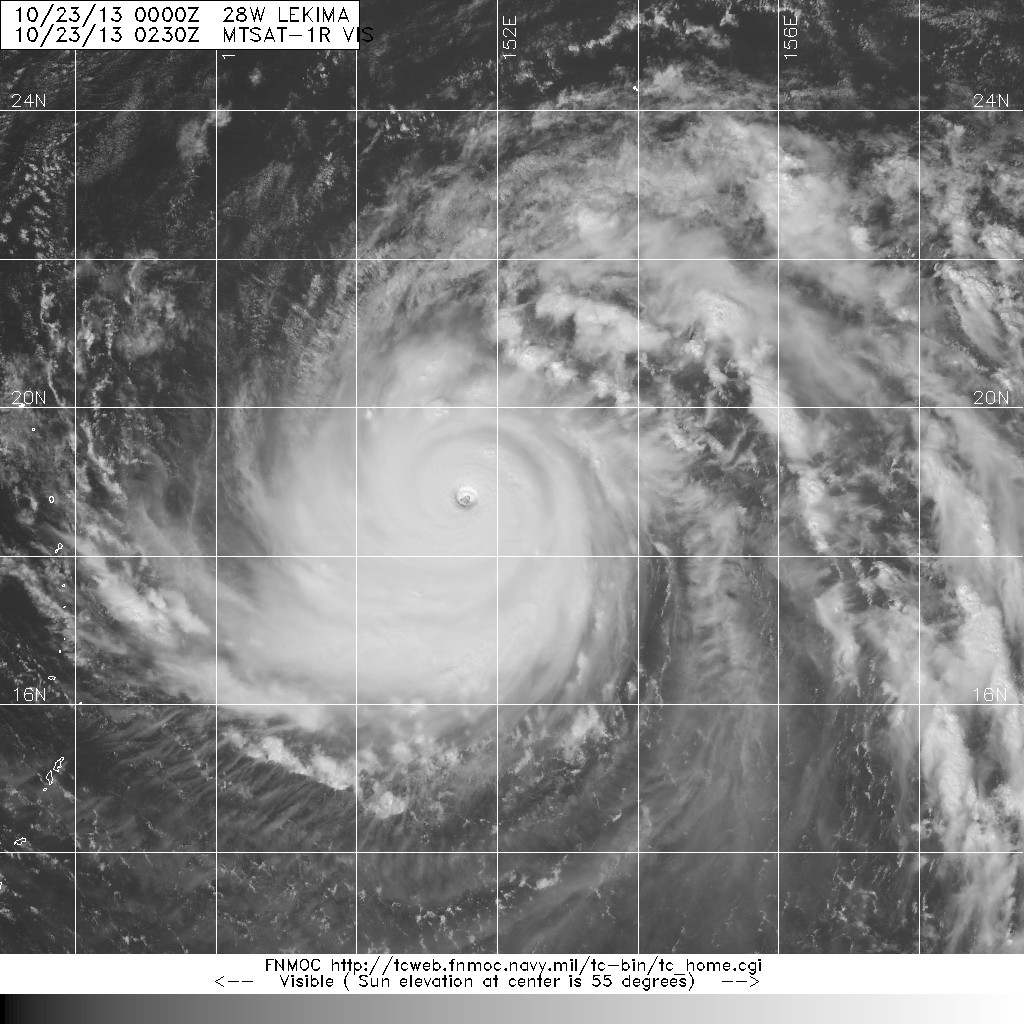
LEKIMA continued to intensify steadily. It reached typhoon intensity on October 22 when an eye developed. At that time the storm appeared elongated in the equatorward direction. LEKIMA's rate of intensification was even greater than FRANCISCO's; it was a category 1 typhoon in the morning, but was upgraded into category 3 and then 4 in subsequent bulletins, and became the third category 5 super typhoon in NW Pacific this year at 2 am the next day. Meanwhile, the JMA estimated LEKIMA's intensity at 60, 80, 100 and 110 knots (111, 148, 185 and 204 km/h) in the bulletins from 8 am October 22 to 2 am October 23, and the peak intensity estimate was 115 knots (213 km/h). Within a day LEKIMA developed a deep central dense overcast with cloud top temperatures plummeting to -80 degrees; this was the primary reason for such a rapid upgrade.
LEKIMA turned NW between October 22 and 23 and accelerated to around 30 km/h. During October 23 the storm gradually became more symmetric in shape. As seen from colour enhanced satellite imageries, LEKIMA's eyewall warmed slightly during the day and dropped again that evening. Its eye remained very clear throughout and the storm remained at category 5 throughout that day.
The storm briefly moved WNW but soon turned increasingly poleward as it reached the southwestern edge of the subtropical ridge. As LEKIMA's latitude increased, it suffered from the same problem as FRANCISCO --- decreasing sea temperatures. The storm's eyewall warmed again and it was downgraded into a category 4 super typhoon at 2 pm on October 24, after staying at category 5 for 36 hours (compared with FRANCISCO's 30 hours). It crossed the ridge axis on October 25, moving at a slightly lower speed.
Since LEKIMA gained latitude faster than FRANCISCO (due to the shape and influence of the ridge), it weakened at a more rapid pace too. It was downgraded into category 3 in the afternoon of October 25. It accelerated rapidly after recurving; its eye became cloud-filled and the storm was gradually torn apart by strong vertical wind shear. LEKIMA finally turned extratropical in late October 26, still carrying hurricane force winds at that time.
此報告撰寫之時,利奇馬為本年度於西北太平洋最東面形成的熱帶氣旋。利奇馬前身的擾動形成時結構較為鬆散,同時由於其緯度較南,距離副熱帶高壓脊南沿有一定距離,它的移動速度較慢。它於 10 月 20 日晚上 8 時增強為熱帶低氣壓 28W,當時它正向北緩慢移動。由於 28W 一帶海洋熱含量極高,28W 迅速增強並於 21 日達到熱帶風暴強度。日本氣象廳將其命名為利奇馬;此名字由越南提供,為一樹名,其果肉為黃色而內有一顆種子。
受副高支配,預測利奇馬將如其它典型轉向風暴般移動;同時由於副高勢力較強,利奇馬的預測移速較高。它結果於轉向前維持平均每小時 25 公里的速度,轉向後速度更超過每小時 50 公里。
利奇馬繼續穩定增強,它於 22 日成為一颱風,並發展出風眼。當時利奇馬的型態較像一橢圓,東西向稍為突出。利奇馬增強的速度比范斯高還要快;它於 22 日早上還是一個一級颱風,於其後的發佈上調至三級、四級,最後於翌日凌晨 2 時增強為本年度西北太平洋第三個五級超級颱風。另一方面,日本氣象廳於 22 日上午 8 時至 23 日上午 2 時的估計強度分別為 60、80、100 及 110 節 (每小時 111、148、185 及 204 公里),而巔峰強度則為 115 節 (每小時 213 公里)。各機構急速上調利奇馬的強度是因為它於一日之內發展出深厚的中心密集雲區,而其雲頂溫度更跌至 -80 度。
利奇馬於 22 及 23 日向西北移動,並加速至每小時約 30 公里。風暴於 23 日變得更為對稱。從色調強化衛星雲圖可見,利奇馬的眼牆溫度於日間稍為上升,但晚間再度下降。風眼於整天維持非常清晰,風暴亦於當天維持五級強度。
利奇馬曾短暫向西北偏西移動,但隨後由於到達副高西沿而逐漸轉北。隨著利奇馬的緯度增加,它遇上與范斯高同樣的問題 --- 海溫下降。它的眼牆再度升溫,風暴於 24 日下午 2 時、維持五級強度 36 小時後被降格至四級超級颱風 (范斯高則維持了 30 小時)。它於 25 日橫過副高脊線,移速略為下降。
副高的型態及影響令利奇馬北移速度比范斯高快,因此它的減弱速度亦較高。利奇馬於 25 日下午減弱為三級颱風。它於轉向後迅速加速,其風眼被雲帶覆蓋,結構亦因強垂直風切變影響而被破壞。利奇馬最終於 26 日較後時間轉化為溫帶氣旋,當時它仍擁有颶風風力。
| Figures 圖片 |


Figures 1a and 1b - Steering flow charts at 8 am October 22 and 25
圖 1a 及 1b - 10 月 22 及 25 日上午 8 時之駛流圖

Figure 2 - Satellite image at 10:30 am October 22 showing both FRANCISCO and LEKIMA as typhoons
圖 2 - 10 月 22 日上午 10 時 30 分之衛星圖顯示范斯高及利奇馬均為颱風

Figure 3 - Forecast tracks from different agencies on October 23
圖 3 - 10 月 23 日之各氣象台預測路徑圖

Figures 4a and 4b - Satellite images of LEKIMA spaced one day apart. The estimated intensities were the same, at 140 knots (category 5).
圖 4a 及 4b - 相隔一天的衛星雲圖,兩圖中利奇馬的估計強度都是 140 節 (五級超級颱風)
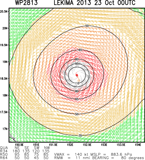
Figure 5 - Calculated wind field chart at 8 am October 23
圖 5 - 10 月 23 日上午 8 時之估算風場圖
| Other Data 其他數據 |
Table 1: Track data from HKWW:
表一 : 香港天氣觀測站之路徑資料
| YYMMDDZZ Lat Long Wind 13102012 103N1608E 025 13102018 106N1608E 035 13102100 114N1609E 045 13102106 122N1607E 055 13102112 131N1601E 060 13102118 139N1593E 065 13102200 151N1582E 075 13102206 162N1568E 105 13102212 171N1554E 120 13102218 181N1539E 140 13102300 186N1522E 140 13102306 190N1509E 140 13102312 194N1498E 140 13102318 199N1487E 140 13102400 206N1476E 140 13102406 214N1465E 135 13102412 225N1456E 130 13102418 236N1446E 125 13102500 250N1443E 120 13102506 270N1444E 115 13102512 293N1450E 105 13102518 317N1467E 095 13102600 343N1494E 085 13102606 368N1519E 075 13102612 394N1553E 065 13102618 402N1590E 055 |
Table 2: Track data from JTWC:
表二 : 聯合颱風警報中心之路徑資料
ID Name YYMMDD ZZZZ Lat Long Basin Wind Pres 28W LEKIMA 131025 1800 31.4N 146.6E WPAC 90 956 |
Last Accessed 最近訪問日期: Sun Sep 08 2024 12:38:07 HKT
Last Modified 最近修訂日期: Mon Jul 24 2023
