
TC Watch / 熱帶氣旋 > Selected TC Review / 重要熱帶氣旋回顧 > 201326W (FRANCISCO 范斯高) [Refresh 更新]
 201326W (FRANCISCO 范斯高) - Profile 檔案 201326W (FRANCISCO 范斯高) - Profile 檔案 |
(Issued on December 8, 2013)
(於 2013 年 12 月 8 日發出)
Brief profile of FRANCISCO 范斯高小檔案:
| JTWC number 聯合颱風警報中心 (JTWC) 號碼 | 26W |
| International number 國際編號 | 1327 |
| Period of existence 生存時期 (JTWC) | 2013/10/16 08 HKT - 2013/10/26 02 HKT |
| Lifetime 壽命 (JTWC) | 9.75 days 日 |
| Maximum 1-minute wind (JTWC) JTWC 一分鐘平均最高中心風速 | 140 knots 節 (Category 5 Super Typhoon 五級超級颱風) |
| Minimum pressure (JTWC) JTWC 最低氣壓 | 918 hPa 百帕 |
| Highest TC signal by HKO (if applicable) 香港天文台發出最高熱帶氣旋警告信號 |
N/A 不適用 |
| Closest point of approach by HKO (if applicable) 香港天文台所示之最接近距離 (如適用) |
N/A 不適用 |
| Time of closest approach by HKO (if applicable) 香港天文台所示之最接近時間 (如適用) |
N/A 不適用 |
| Lowest pressure recorded at HKO (if applicable) 香港天文台錄得的最低氣壓 (如適用) |
N/A 不適用 |
TC track from HKWW 本站的熱帶氣旋路徑圖:
| Past HKWW Bulletins on FRANCISCO 本站有關范斯高的發佈 |
Please click here for bulletins on FRANCISCO. 請按這裡。
| Storm Summary 氣旋摘要 |
Unless otherwise stated, all times below are in Hong Kong Standard Time (UTC+8)
除非特別註明,下文時間均為香港標準時間 (協調世界時加 8 小時)
FRANCISCO is the second category 5 super typhoon in northwest Pacific this year.
A disturbance developed near Guam and was upgraded into tropical depression 26W by the JTWC on October 16. The system was in an unusual steering environment in the sense that it was moving southwest due to a strong subtropical ridge located west and northwest of it. However, numerical forecasts were in close agreement and indicated that the storm would turn poleward abruptly after a brief southwesterly track, as the ridge would intensify to the east of 26W and assume dominance.
26W was upgraded into a tropical storm by the JMA at 8 pm that day, and was named FRANCISCO. This name was provided by the USA and is a Chamorro male name. At that time the ridge started building east of FRANCISCO, and the storm decelerated gradually. It reached the southernmost position in early October 17 and intensified rather quickly, developing from a tropical storm to a typhoon in around 12 hours' time. A banding eye emerged in the morning which became increasingly compact during the day.
As the eastern ridge started to influence FRANCISCO, the storm turned northwards with slight increase in longitude. Numerical forecast tracks and predictions from official agencies were very tight and they generally forecast a change in direction to the NW as FRANCISCO reached the western periphery of the subtropical ridge. This would then be followed by a turn back to the north later on. As FRANCISCO was expected to move across warm seas with very low vertical wind shear, the intensity forecast was quite optimistic.
FRANCISCO continued to intensify quickly throughout October 17, reaching upper category 3 level (110 knots / 204 km/h from the JTWC) by 2 am on October 18. FRANCISCO developed a central dense overcast with symmetric outer spiraling bands, although the upper-level convections spanned a larger area in its northern semicircle. The HKO upgraded FRANCISCO into a super typhoon in its weather chart for 2 pm that day. The JMA also revised its intensity estimate upwards to 100 knots (185 km/h) that night.
In response to the shape of the subtropical ridge, FRANCISCO turned northwest as predicted in the night of October 18. The ridge west of FRANCISCO could be seen weakening at the same time. As the storm developed, its eyewall cloud top temperatures dropped. It was estimated to be a category 4 super typhoon (135 knots (250 km/h) from the JTWC) at 2 am on October 19, and was upgraded into category 5 (140 knots or 259 km/h) 12 hours later. Satellite imageries revealed a clear, round eye with eyewall cloud top reaching -70 degrees. The storm's outer convective bands also became more symmetric. FRANCISCO moved WNW during the period with category 5 intensity, which lasted for a day until the afternoon of October 20. The JMA, meanwhile, assessed FRANCISCO's maximum intensity at 105 knots (194 km/h), while the HKO's estimate was 230 km/h (124 knots).
By this time, there were some discrepancies among model predictions. They started to depict a slight strengthening of the ridge which would push FRANCISCO further westwards before recurving, but there were some variability to the extent of this westward push and the acuteness of the recurvature. This led to a huge uncertainty as to whether the storm would strike Japan. Forecasts initially predicted landfall near Tokyo, but the recurvature turned out to be sharper than expected and those forecasts were eventually amended to making no landfall at all.
FRANCISCO started to weaken in the latter part of October 20 as sea temperatures dropped after the storm passed 18°N. Clouds started to fill its eye and it weakened into a category 4 system that afternoon. The storm reverted to its NNW track until October 22, when it started to turn WNW again. It continued to weaken, but the rate became slower and the storm stayed at category 2/3 intensity for around two days. Its central dense overcast collapsed but the banding eye remained apparent.
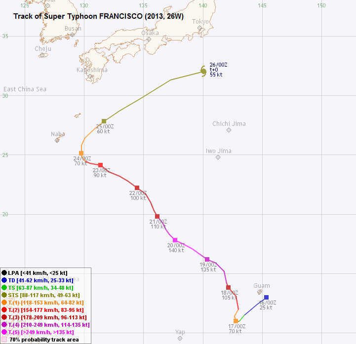
FRANCISCO decelerated on October 23 and turned north the next day. It picked up speed gradually as it entered the westerlies. Due to stronger wind shear the storm's structure started to collapse on October 25. It turned ENE on October 26 and turned extratropical while it passed south of Japan. It is interesting to note that the distance between FRANCISCO and another storm LEKIMA decreased to around 900 km at that time, but their interaction was negligible compared with the strong steering flow.
范斯高為本年西北太平洋第二個五級超級颱風。
一個於關島附近發展的擾動於 10 月 16 日被聯合颱風警報中心升格為熱帶低氣壓 26W。該系統處於一個較不尋常的駛流配置中;受其西及西北面的強副熱帶高壓脊之影響,26W 當時正向西南移動。但是,數值預報模式一致認為 26W 以東的高壓脊將增強並成為主導力量,使 26W 改向偏北移動。
26W 於當天晚上 8 時被日本氣象廳升格為熱帶風暴,並被命名為范斯高。此名字由美國提供,是一查摩洛男性名字。風暴命名時副高正於范斯高以東建立,它因而逐漸減速。范斯高於 17 日早段到達其最低緯度,並以較快速度增強,只用了 12 小時便由熱帶風暴發展為颱風。風暴亦於早上發展出一雲捲風眼,並於當天逐漸變得緊密。
隨著東面脊場開始影響范斯高,它開始轉向偏北移動,經度稍為增加。數值預報及官方預測幾乎完全一樣,范斯高將因到達副高西沿而改向西北移,隨後轉回偏北路徑。由於預測范斯高將經過溫暖的海域且垂直風切變較低,其強度預測頗為樂觀。
范斯高於 17 天繼續快速增強,並於 18 日凌晨 2 時增強至三級颱風上限 (聯合颱風警報中心估計風速 110 節 / 每小時 204 公里)。范斯高發展出中心密集雲區,其外圍有對稱螺旋雲帶 (雖然高層雲帶於風暴北面較為發達)。從天氣圖可得知香港天文台於當天下午 2 時將范斯高升格為超強颱風,而日本氣象廳亦於當晚將范斯高的估計強度上調至 100 節 (每小時 185 公里)。
受副高型態影響,范斯高於 18 日如預期轉向西北移動,而范斯高西面的脊場亦有減弱之勢。隨著風暴發展,其眼牆雲頂溫度逐漸下降。它於 19 日凌晨 2 時的估算強度達四級超級颱風級別 (聯合颱風警報中心估計風速 135 節 / 每小時 250 公里),並於 12 小時後進一步升格為五級。從衛星圖上可見一渾圓清晰的風眼,眼牆雲頂溫度跌至 -70 度,而外圍環流亦變得更為對稱。范斯高於五級強度時向西北偏西移動,而此強度維持了 30 小時,直至 20 日下午為止。日本氣象廳估算范斯高的巔峰強度為 105 節 (每小時 194 公里),而香港天文台的則為每小時 230 公里 (124 節)。
此時,電腦模式的預測出現分歧。由於預料副高西沿將稍為增強,它們預測范斯高將於轉向前進一步西移,但各模式對於西移幅度及轉向角度並沒有共識。這意味著難以估計范斯高會否吹襲日本。初期的預測曾顯示風暴會於東京一帶登陸,但由於轉向角度比先前估計更高,各預測逐步改為不登陸日本。
由於水溫於北緯 18 度以北下降,范斯高於 20 日後期開始減弱。它的風眼被雲層填入,風暴於下午減弱為四級颱風。范斯高的路徑亦轉為西北偏北,直至 22 日再度轉為西北偏西。風暴繼續減弱,但減弱速度逐步放緩,它維持二/三級颱風強度達兩天。雖然范斯高的中心密集雲區瓦解,但其雲捲風眼仍然清晰。
范斯高於 23 日減速,翌日轉向偏北移動。其後受西風帶影響,范斯高的移速逐漸加快。由於風切上升,風暴結構於 25 日開始被破壞。范斯高於 26 日轉向東北偏東移動,並於橫過日本以南海域期間轉化為溫帶氣旋。有趣的是,此時范斯高與另一風暴利奇馬的距離跌至接近 900 公里,但由於背景氣流猛烈,它們之間的相互影響變得微不足道。
| Figures 圖片 |


Figures 1a and 1b - FRANCISCO intensified quickly in its first 24 hours of formation, from a tropical depression to typhoon
圖 1a 及 1b - 范斯高於形成後 24 小時快速由熱帶低氣壓增強為颱風

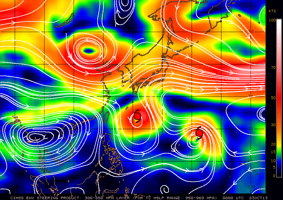
Figure 2 - 500-hPa upper level weather map showing the mechanism behind FRANCISCO's unusual initial track
圖 2 - 500 百帕高空天氣圖顯示范斯高初期移動路徑較不尋常的原因

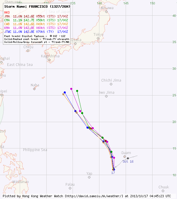
Figures 3a and 3b - Steering flow charts at 8 am October 17 and 23
圖 3a 及 3b - 10 月 17 及 23 日上午 8 時之駛流圖


Figures 4a and 4b - FRANCISCO at maximum intensity
圖 4a 及 4b - 范斯高到達其巔峰強度
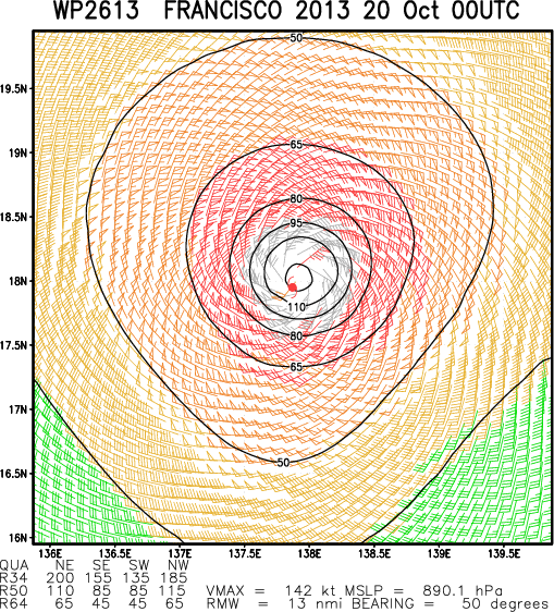
Figure 5 - Calculated wind field chart at 8 am October 20
圖 5 - 10 月 20 日上午 8 時之估算風場圖


Figures 6a to 6c - Forecast tracks from different agencies: October 17, 21 and 24
圖 6a 至 6c - 10 月 17、21 及 24 日各氣象台的預測路徑圖
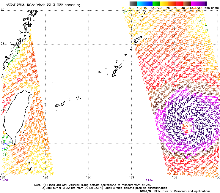
Figure 7 - FRANCISCO maintained a wide storm radius at its weakening stage
圖 7 - 雖然范斯高已減弱,但其暴風圈仍然廣闊

Figure 8 - FRANCISCO became an extratropical cyclone as it crossed the seas south of Japan
圖 6 - 范斯高於橫過日本以南海域時轉化為溫帶氣旋
| Other Data 其他數據 |
Table 1: Track data from HKWW:
表一 : 香港天氣觀測站之路徑資料
| YYMMDDZZ Lat Long Wind 13101600 130N1454E 025 13101606 124N1446E 030 13101612 115N1435E 040 13101618 110N1431E 055 13101700 110N1428E 070 13101706 114N1427E 075 13101712 120N1430E 085 13101718 131N1428E 095 13101800 138N1422E 105 13101806 142N1420E 115 13101812 152N1418E 125 13101818 159N1411E 135 13101900 162N1404E 135 13101906 167N1397E 140 13101912 171N1391E 140 13101918 175N1383E 140 13102000 178N1377E 140 13102006 183N1372E 135 13102012 187N1369E 125 13102018 193N1366E 115 13102100 198N1362E 110 13102106 203N1359E 105 13102112 210N1356E 105 13102118 217N1352E 100 13102200 222N1345E 100 13102206 228N1337E 100 13102212 232N1330E 100 13102218 236N1321E 100 13102300 241N1314E 090 13102306 243N1305E 085 13102312 245N1301E 080 13102318 249N1298E 075 13102400 251N1298E 070 13102406 258N1298E 070 13102412 264N1301E 070 13102418 272N1309E 065 13102500 278N1317E 060 13102506 287N1330E 060 13102512 297N1347E 060 13102518 313N1373E 060 13102600 320N1401E 055 |
Table 2: Track data from JTWC:
表二 : 聯合颱風警報中心之路徑資料
ID Name YYMMDD ZZZZ Lat Long Basin Wind Pres 26W FRANCISCO 131025 1200 29.8N 135.2E WPAC 50 985 |
Last Accessed 最近訪問日期: Sun Sep 08 2024 12:46:46 HKT
Last Modified 最近修訂日期: Mon Jul 24 2023
