
TC Watch / 熱帶氣旋 > Selected TC Review / 重要熱帶氣旋回顧 > 201111W (MUIFA 梅花) [Refresh 更新]
 201111W (MUIFA 梅花) - Profile 檔案 201111W (MUIFA 梅花) - Profile 檔案 |
(Issued on August 15, 2011)
(於 2011 年 8 月 15 日發出)
Brief profile of MUIFA 梅花小檔案:
| JTWC number 聯合颱風警報中心 (JTWC) 號碼 | 11W |
| International number 國際編號 | 1109 |
| Period of existence 生存時期 (JTWC) | 2011/07/25 20 HKT - 2011/08/08 20 HKT |
| Lifetime 壽命 (JTWC) | 14.00 days 日 |
| Maximum 1-minute wind (JTWC) JTWC 一分鐘平均最高中心風速 | 140 knots 節 (Category 5 Super Typhoon 五級超級颱風) |
| Minimum pressure (JTWC) JTWC 最低氣壓 | 918 hPa 百帕 |
| Highest TC signal by HKO (if applicable) 香港天文台發出最高熱帶氣旋警告信號 |
N/A 不適用 |
| Closest point of approach by HKO (if applicable) 香港天文台所示之最接近距離 (如適用) |
N/A 不適用 |
| Time of closest approach by HKO (if applicable) 香港天文台所示之最接近時間 (如適用) |
N/A 不適用 |
| Lowest pressure recorded at HKO (if applicable) 香港天文台錄得的最低氣壓 (如適用) |
N/A 不適用 |
TC track from HKWW 本站的熱帶氣旋路徑圖:

| Past HKWW Bulletins on MUIFA 本站有關梅花的發佈 |
Please click here for bulletins on MUIFA. 請按這裡。
| Storm Summary 氣旋摘要 |
Unless otherwise stated, all times below are in Hong Kong Standard Time (UTC+8)
除非特別註明,下文時間均為香港標準時間 (協調世界時加 8 小時)
MUIFA's whole life lasted for 14 days, the longest since Super Typhoon PARMA in 2009.
Just as another tropical cyclone NOCK-TEN developed, a disturbance east of it strengthened into the eleventh tropical depression this year in the northwestern Pacific on July 25. 11W moved west quickly under the steering ridge north of it. Initial forecasts called for a gradual poleward turn, as that subtropical ridge was expected to retreat. 11W remained disorganized on July 27. Since multiple vortices appeared within the large patch of convections associated with 11W, relocations were made in the first few bulletins.
Convections started to concentrate on July 28. The JMA upgraded 11W into tropical storm MUIFA at 14 HKT. The name was contributed by Macau, meaning plum blossom. By that time MUIFA had already moved to west of 135°E. All agencies and numerical models predicted a sharp turn towards the north as an equatorial anticyclone developed to the east and the ridge north of MUIFA was weakening. MUIFA promptly made a 90-degree turn on July 29 and continued to intensify. Shear finally eased as MUIFA travelled north, and this facilitated strengthening.
A central dense overcast (CDO) gradually appeared on July 30. Agencies upgraded MUIFA into a typhoon as an eye started to appear. A tiny eye popped out at the centre of the CDO in the afternoon, signifying rapid strengthening. The agencies that use 10-minute averages raised their strength estimations from 65 knots to about 85 knots in just 6 hours, and further to 95 knots at 02 HKT on July 31. As for the JTWC which uses 1-minute averages, upward strength adjustment was more dramatic since the appearance of the eye together with the very low cloud-top temperatures of the eyewall greatly influenced the Dvorak pattern strength. MUIFA was estimated to carry winds of 95 knots at 14 HKT on July 30, adjusted to 115 knots (category 4) and 140 knots (category 5) at 20 HKT and 02 HKT (on the next day) respectively. MUIFA's strength peaked overnight on July 31.
Due to the equatorial anticyclone, MUIFA acquired some eastward track component between July 29 and 30. However, the subtropical ridge north of MUIFA still had some influence as the storm tracked north and gradually approached its southern periphery. It allowed the storm to turn NW briefly on July 31 at a slower speed. Model consensus was that MUIFA would travel north until it reached around 23°N, after which the Pacific ridge would extend again and join the high pressure cell near western Japan to make MUIFA turn west again.
Cloud top temperatures rose in the latter part of July 31 and the northern part of the CDO was thinning out. These signs showed that MUIFA had weakened slightly into a category 4 typhoon. The storm also turned NE again, before turning north on August 1.
MUIFA started to carry out an eyewall replacement cycle on August 1, and a large eye could be observed on the next day. The storm gradually turned NW and then W on August 3, and the Ryukyu Islands and the whole eastern China was preparing for MUIFA's impact. The storm carried out another around of eyewall replacement on August 3 as a double eyewall was observed on satellite images. Okinawa was spared a direct hit with MUIFA passing around 100 km to its south, but continuous gales (or stronger) were recorded for more than a day because MUIFA turned NW as it reached 128°E, lengthening the period of which Okinawa was within the storm's gale radius.
Due to decreasing ocean heat content, MUIFA continued to weaken as it travelled across the East China Sea. By August 6 it was apparent that the storm turned poleward earlier than expected, and that Shanghai was spared (before this forecasts had been consistently suggesting a close encounter). The storm accelerated towards the north and passed to the east of the tip of Shandong Peninsula early on August 8, when it weakened into a severe tropical storm.
MUIFA crossed the ridge axis and recurved at Korea Bay. It made landfall at western North Korea near sunset on August 8, and entered northeastern China a few hours afterwards. MUIFA gradually weakened and dissipated near the Liaoning-Heilongjiang border early on August 9.
梅花生命長達 14 天,是自 2009 年超級颱風芭瑪以來最長。
在熱帶氣旋洛坦形成的同時,東面的另一個熱帶擾動於 7 月 25 日增強為本年西北太平洋第 11 個熱帶低氣壓。由於 11W 處於副熱帶高壓脊以南,它快速向西移動。初始預報指副高將東退,11W 會逐步轉向北移。11W 組織於 27 日繼續鬆散,廣闊對流上出現數個漩渦,令其被重新定位。
對流於 28 日漸趨集中。日本氣象廳於下午 2 時升格 11W 為熱帶風暴梅花,而此名則由澳門提供,當時梅花已西移至東經 135 度以西的地方。所有機構和數值預報模式均預測梅花即將轉北,這是由於赤道反氣旋於梅花東部增強,而副高則減弱。梅花於 29 日準時地轉向,並繼續增強。隨著梅花轉北,風切終於減低,增強速度得以加快。
至 30 日,一中心密集雲區開始出現。由於風眼開始形成,各機構均把梅花升格為颱風。當天下午一細小風眼於雲區中間出現,揭示梅花在急速增強中。使用 10 分鐘平均風速之機構於 6 小時內把梅花之強度由 65 節調高至 85 節,並於 31 日凌晨 2 時再度上調至 95 節。至於 JTWC,由於使用 1 分鐘平均風速,風眼的出現和極低眼牆雲頂溫度令風速快速上調,由 30 日下午 2 時的 95 節上升至 8 時之 115 節 (四級颱風) 和翌日上午 2 時之 140 節 (五級超級颱風)。梅花的強度於 31 日凌晨見頂。
受赤道反氣旋的影響,梅花於 29 至 30 日期間稍向東移,但副高勢力仍在,隨風暴北移它開始接近其南端,這使梅花於 31 日短暫向西北移動,速度減慢。預報模式一致地認為梅花將北移至約北緯 23 度,隨後太平洋副高西伸並接合於日本西部的高壓,從而令梅花再度西移。
31 日後段梅花眼牆雲頂溫度上升,中心密集雲區北面轉薄,梅花減弱為四級颱風。梅花再次轉向東北,隨後於 8 月 1 日回復正北路徑。
梅花於 1 日開始眼牆置換週期,當天較後時間風眼增大。梅花之後於 3 日向西北轉西移動,琉球群島和中國東部沿岸地區開始準備防風工作。梅花在 3 日再作眼牆置換,雲圖上可清楚見到其雙重眼壁結構。梅花在沖繩島以南約 100 公里掠過,但由於它在到達東經 128 度時改向西北移,該地長時間處於烈風圈中,導致沖繩島受烈風或更強的狂風侵襲達超過 24 小時。
隨著海面熱含量降低,梅花在橫過東海時逐漸減弱。至 6 日梅花已明顯向偏北移動,上海因而避過梅花直趨 (早前預測預計上海將受梅花直襲)。梅花其後加速北移,在 8 日於山東半島對開海面通過,並減弱為強烈熱帶風暴。
梅花之後越過脊線,於朝鮮灣轉向東北偏北。它在 8 日傍晚於北韓西部登陸,數小時後進入中國東北部。梅花於內陸逐步減弱,在 9 日早上於遼寧與黑龍江邊界一帶消散。
| Figures 圖片 |


Figures 1a and 1b - Steering flow charts at 14 HKT on July 29 and August 3
圖 1a 及 1b - 7 月 29 日及 8 月 3 日下午 2 時之駛流場圖


Figures 2a and 2b - MUIFA at peak intensity. Note the very low eyewall cloud-top temperatures on the left panel
圖 2a 及 2b - 梅花接近巔峰強度時的衛星圖片。留意左圖上梅花眼牆雲頂溫度十分低

Figure 3 - Calculated wind field at 08 HKT on July 31
圖 3 - 7 月 31 日上午 8 時之估算風場圖


Figures 4a and 4b - Wind field charts on July 30 and August 6. Although MUIFA was weaker on August 6, its wind radii had expanded
圖 4a 及 4b - 7 月 30 及 8 月 6 日之風場圖。雖然梅花於 8 月 6 日強度較低,但其風圈則更為廣闊


Figures 5a and 5b - Forecast tracks from different agencies on July 31 and August 4. Shanghai was once predicted as MUIFA's landfall location
圖 5a 及 5b - 7 月 31 及 8 月 4 日之官方氣象台預測路徑。它們曾預計梅花會直趨上海


Figures 6a and 6b - MUIFA displaying double eyewall feature
圖 6a 及 6b - 梅花曾出現雙重眼壁結構
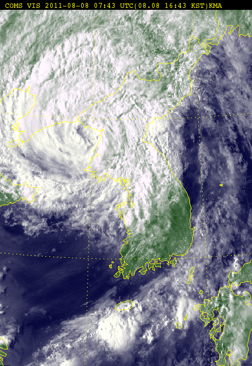
Figure 7 - MUIFA about to make landfall at North Korea
圖 7 - 梅花即將於北韓登陸
| Other Data 其他數據 |
Table 1: Track data from HKWW:
表一 : 香港天氣觀測站之路徑資料
| YYMMDDZZ Lat Long Wind 11072506 053N1475E 020 11072512 057N1472E 025 11072518 058N1457E 030 11072600 061N1444E 030 11072606 081N1431E 030 11072612 089N1424E 030 11072618 094N1420E 030 11072700 100N1418E 030 11072706 105N1409E 030 11072712 110N1401E 030 11072718 120N1383E 030 11072800 122N1362E 035 11072806 119N1350E 040 11072812 122N1340E 040 11072818 124N1332E 045 11072900 125N1332E 050 11072906 128N1330E 050 11072912 139N1327E 050 11072918 148N1331E 055 11073000 158N1337E 060 11073006 162N1330E 080 11073012 166N1328E 115 11073018 167N1324E 140 11073100 169N1326E 135 11073106 171N1329E 125 11073112 178N1335E 125 11073118 186N1335E 125 11080100 189N1337E 115 11080106 198N1341E 110 11080112 206N1341E 110 11080118 215N1342E 105 11080200 220N1341E 105 11080206 228N1341E 105 11080212 233N1338E 105 11080218 238N1332E 105 11080300 242N1327E 105 11080306 243N1320E 105 11080312 245N1314E 095 11080318 245N1306E 095 11080400 248N1295E 095 11080406 248N1291E 095 11080412 250N1286E 095 11080418 250N1281E 095 11080500 253N1276E 095 11080506 257N1273E 095 11080512 261N1269E 090 11080518 265N1264E 085 11080600 272N1259E 085 11080606 286N1252E 075 11080612 293N1248E 075 11080618 305N1245E 070 11080700 320N1244E 070 11080706 332N1241E 070 11080712 347N1239E 065 11080718 358N1235E 060 11080800 374N1240E 060 11080806 386N1242E 055 11080812 406N1251E 045 11080818 423N1255E 035 11080900 442N1265E 025 |
Table 2: Track data from JTWC:
表二 : 聯合颱風警報中心之路徑資料
ID Name YYMMDD ZZZZ Lat Long Basin Wind Pres 11W MUIFA 110808 1200 40.6N 124.8E WPAC 40 993 |
Last Accessed 最近訪問日期: Sun Sep 08 2024 12:43:53 HKT
Last Modified 最近修訂日期: Mon Jul 24 2023
