
TC Watch / 熱帶氣旋 > Selected TC Review / 重要熱帶氣旋回顧 > 201104W (SONGDA 桑達) [Refresh 更新]
 201104W (SONGDA 桑達) - Profile 檔案 201104W (SONGDA 桑達) - Profile 檔案 |
(Issued on June 5, 2011)
(於 2011 年 6 月 5 日發出)
Brief profile of SONGDA 桑達小檔案:
| JTWC number 聯合颱風警報中心 (JTWC) 號碼 | 04W |
| International number 國際編號 | 1102 |
| Period of existence 生存時期 (JTWC) | 2011/05/20 14 HKT - 2011/05/29 20 HKT |
| Lifetime 壽命 (JTWC) | 9.25 days 日 |
| Maximum 1-minute wind (JTWC) JTWC 一分鐘平均最高中心風速 | 140 knots 節 (Category 5 Super Typhoon 五級超級颱風) |
| Minimum pressure (JTWC) JTWC 最低氣壓 | 918 hPa 百帕 |
| Highest TC signal by HKO (if applicable) 香港天文台發出最高熱帶氣旋警告信號 |
N/A 不適用 |
| Closest point of approach by HKO (if applicable) 香港天文台所示之最接近距離 (如適用) |
N/A 不適用 |
| Time of closest approach by HKO (if applicable) 香港天文台所示之最接近時間 (如適用) |
N/A 不適用 |
| Lowest pressure recorded at HKO (if applicable) 香港天文台錄得的最低氣壓 (如適用) |
N/A 不適用 |
TC track from HKWW 本站的熱帶氣旋路徑圖:

| Past HKWW Bulletins on SONGDA 本站有關桑達的發佈 |
Please click here for bulletins on SONGDA. 請按這裡。
| Storm Summary 氣旋摘要 |
Unless otherwise stated, all times below are in Hong Kong Standard Time (UTC+8)
除非特別註明,下文時間均為香港標準時間 (協調世界時加 8 小時)
SONGDA is the second named storm in northwestern Pacific Ocean this year, and is the first to attain category 5 strength.
An area of low pressure developed around 600 km east of Yap in the middle of May. The low pressure acquired strength and was upgraded into tropical depression 04W by the JTWC at 14 HKT on May 20. At that time, numerical model forecasts had already been consistent in depicting a recurvature east of the Philippines, which turned out to be the true outcome. The storm developed slowly at first due to hindered divergence, and the JTWC revised their past track storm intensity downward on the next day (May 21) as the storm failed to organize, especially in the northern semicircle.
04W was at that time south of the steering subtropical ridge, and a persistent WNW track was expected. The cyclone gathered strength on May 21 and the Japan Meteorological Agency (JMA) upgraded it into a tropical storm at 02 HKT on May 22, naming it SONGDA. The name was provided by Vietnam, which is the name of a river in the northern part of the country.
SONGDA continued to remain at low latitudes in the next couple of days. Forecasts made by major official agencies were very consistent, putting the storm on an increasingly poleward track towards the seas just east of Luzon. As divergence improved, SONGDA gradually intensified into a severe tropical storm later on May 22. Intensification slowed down again and SONGDA did not gain strength significantly in the next two days. An eye finally popped out in satellite imagery on May 25, which prompted agencies to upgrade SONGDA into a typhoon. Still, SONGDA was only expected to intensify gradually and the JTWC was estimating a peak strength of 125 knots (232 km/h) to be attained on May 27.
After maintaining its coverage for an extended period of time, the subtropical ridge finally showed signs of retreat as waves of midlatitude troughs attacked it from the north. SONGDA made a sharp NW turn on May 25, perhaps compensating the overly westward track during the previous day. SONGDA's circulation became more symmetrical as time passed, and a central dense overcast could be identified clearly on satellite images. It attained category 4 status in the small hours of May 26, and then deepened into category 5 in the afternoon when it was about 300 km east of Luzon. At its peak, the JTWC estimated SONGDA's intensity to be 140 knots (260 km/h), while the JMA and HKO's (10-minute average) estimates were 105 knots (195 km/h) and 110 knots (205 km/h) respectively.
By May 27, SONGDA was already situated at the western periphery of the subtropical ridge, and was accelerating slightly towards the north. SONGDA's eyewall cloud-top temperatures rose, signaling a weakening trend. It weakened into a category 4 super typhoon by daybreak. Clouds thickened near the eye, although still clearly visible. SONGDA turned NNE as it crossed the Luzon Strait. Although not hit directly by SONGDA, a sea warning was issued in Taiwan to alert citizens there about the rough waves and squalls near the eastern coast.
SONGDA accelerated rapidly towards the NE on May 28 as it skirted Okinawa. Heightening vertical wind shear started to affect SONGDA's core structure, and it weakened significantly during the day. SONGDA finally turned into an extratropical cyclone as it reached the southern coast of Honshu, Japan.
桑達是本年西北太平洋第二個被命名的熱帶氣旋,且是第一個到達五級強度的颱風。
一個低壓區於五月中旬在雅蒲島以東約 600 公里發展。該低壓區逐漸增強,在 5 月 20 日下午 2 時被聯合颱風警報中心 (JTWC) 升格為熱帶低氣壓 04W。與此同時,多個數值預報模式均一致預測 04W 將於菲律賓以東轉向,而最後此預測亦如期實現。由於輻散被限制,04W 初期發展速度緩慢,JTWC 更於翌日 (21 日) 將其最佳路徑強度下調。04W 未能有效地組織起來,北半圓情況更甚。
04W 當時處於副熱帶高壓脊以南,穩定地向西北偏西移動。它於 21 日增強為熱帶風暴,被日本氣象廳 (JMA) 命名為桑達。此名由越南提供,為該國北部一條河流的名字。
桑達於未來數天緯度增加不多。各大氣象台的預測亦頗為一致,即桑達將於呂宋以東轉北。隨著輻散轉好,桑達於 22 日增強為強烈熱帶風暴。其後桑達增強速度再度放緩,兩天內只增強少許。風眼最終在 25 日形成,氣象台均將其升格為颱風。當時預料桑達將只會逐步增強,JTWC 估計它將於 27 日達到顛峰強度 125 節 (每小時 232 公里)。
副高於過去數天呈現強勢,但終在多道西風槽侵擊下開始減弱。桑達於 25 日突然轉向西北移動,或許是對前一天的偏西路徑作出調節。隨著時間過去,桑達的環流變得更為對稱,中心密集雲區於衛星圖片上清楚可見。它在 28 日凌晨達到四級颱風強度,繼而在當天下午於呂宋以東約 300 公里的海面上增強為五級超級颱風。聯合颱風警報中心、日本氣象廳和香港天文台分別估計桑達的巔峰強度為 140、105 和 110 節 (即每小時 260、195 和 205 公里)。
桑達於 27 日處於副高西沿,向偏北加速移動。桑達的眼牆雲頂溫度開始升高,揭示其減弱之勢。它於破曉時份減弱為四級超級颱風。風眼附近雲量增多,但仍能於衛星圖片上清晰見到。桑達在橫過呂宋海峽時轉向東北偏北移動。雖然它並未正面吹襲台灣,該地亦對其發出海上颱風警報,以警示居民東岸有大浪和狂風。
其後,桑達於 28 日加速向東北移動,掠過沖繩島。垂直風切變上升破壞桑達的中心結構,因而它於當天快速減弱。桑達最後在到達日本本州南部時演變為溫帶氣旋。
| Figures 圖片 |

Figure 1 - Steering flow chart at 14 HKT on May 22
圖 1 - 5 月 22 日下午 2 時之駛流場圖
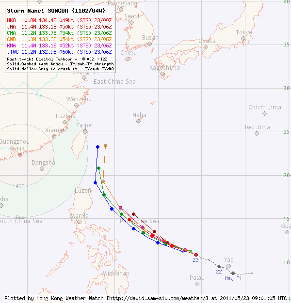
Figure 2 - Official forecast tracks at 14 HKT on May 23
圖 2 - 5 月 23 日下午 2 時之官方預測路徑
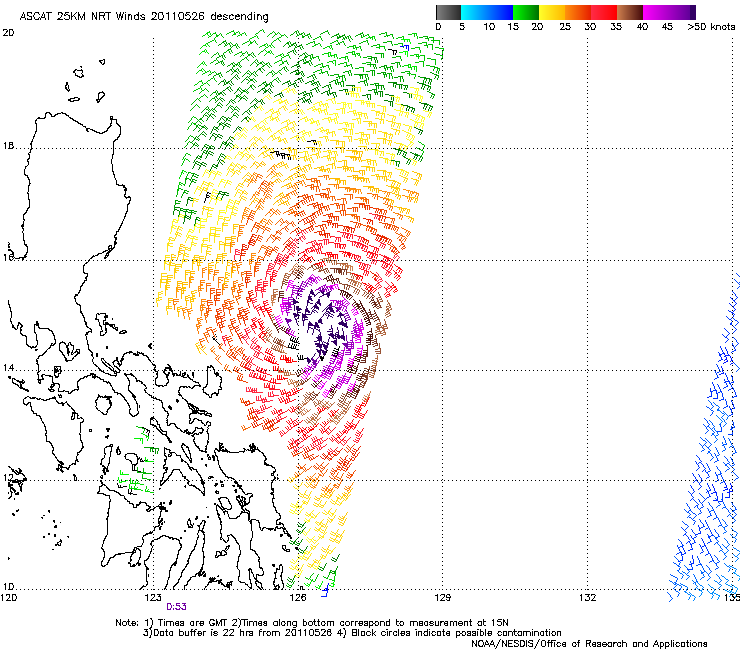
Figure 3 - Wind field at 08 HKT on May 26
圖 3 - 5 月 26 日上午 8 時之風場圖


Figures 4a and 4b - SONGDA at peak intensity. Its eye is very clear on these colour-enhanced infrared images
圖 4a 及 4b - 桑達接近巔峰強度時的衛星圖片。桑達的風眼在這兩張色調強化紅外線雲圖上清晰可見

Figure 5 - Calculated wind field at 08 HKT on May 27
圖 5 - 5 月 27 日上午 8 時之估算風場圖

Figure 6 - SONGDA turning into an extratropical cyclone
圖 6 - 桑達正轉化為溫帶氣旋
| Other Data 其他數據 |
Table 1: Track data from HKWW:
表一 : 香港天氣觀測站之路徑資料
| YYMMDDZZ Lat Long Wind 11051918 080N1425E 020 11052000 081N1420E 025 11052006 084N1416E 030 11052012 085N1410E 035 11052018 087N1395E 030 11052100 088N1388E 030 11052106 089N1385E 030 11052112 091N1380E 035 11052118 091N1375E 040 11052200 095N1370E 045 11052206 100N1365E 045 11052212 102N1359E 050 11052218 105N1350E 055 11052300 109N1340E 055 11052306 112N1330E 055 11052312 117N1322E 055 11052318 118N1315E 055 11052400 120N1310E 060 11052406 124N1301E 065 11052412 126N1293E 065 11052418 123N1285E 075 11052500 124N1281E 090 11052506 127N1278E 105 11052512 132N1274E 105 11052518 139N1272E 115 11052600 147N1265E 120 11052606 156N1258E 130 11052612 162N1251E 140 11052618 172N1244E 140 11052700 182N1239E 130 11052706 193N1234E 130 11052712 204N1231E 125 11052718 216N1232E 115 11052800 231N1238E 105 11052806 248N1250E 090 11052812 266N1266E 085 11052818 286N1292E 075 11052900 307N1316E 065 11052906 330N1341E 050 11052912 344N1366E 040 |
Table 2: Track data from JTWC:
表二 : 聯合颱風警報中心之路徑資料
ID Name YYMMDD ZZZZ Lat Long Basin Wind Pres 04W SONGDA 110529 1800 34.6N 137.5E WPAC 25 1001 |
Last Accessed 最近訪問日期: Sun Sep 08 2024 12:43:28 HKT
Last Modified 最近修訂日期: Mon Jul 24 2023
