
TC Watch / 熱帶氣旋 > Selected TC Review / 重要熱帶氣旋回顧 > 201004W (CHANTHU 燦都) [Refresh 更新]
 201004W (CHANTHU 燦都) - Profile 檔案 201004W (CHANTHU 燦都) - Profile 檔案 |
(First draft issued on August 1, 2010; final version issued on August 11, 2010)
(初稿於 2010 年 8 月 1 日發出,最後版本於 8 月 11 日上載)
Additional Information 附加資料 : Wind Speed Data for TCs that Have Affected Hong Kong 影響香港氣旋之風速數據
Brief profile of CHANTHU 燦都小檔案:
| JTWC number 聯合颱風警報中心 (JTWC) 號碼 | 04W |
| International number 國際編號 | 1003 |
| Period of existence 生存時期 (JTWC) | 2010/07/18 14 HKT - 2010/07/22 20 HKT |
| Lifetime 壽命 (JTWC) | 4.25 days 日 |
| Maximum 1-minute wind (JTWC) JTWC 一分鐘平均最高中心風速 | 75 knots 節 (Category 1 Typhoon 一級颱風) |
| Minimum pressure (JTWC) JTWC 最低氣壓 | 967 hPa 百帕 |
| Highest TC signal by HKO (if applicable) 香港天文台發出最高熱帶氣旋警告信號 |
3 (Strong Wind Signal 強風信號) |
| Closest point of approach by HKO (if applicable) 香港天文台所示之最接近距離 (如適用) |
WSW 330 km (real-time warning 實時報告) / SW 330 km (TC report 熱帶氣旋報告) |
| Time of closest approach by HKO (if applicable) 香港天文台所示之最接近時間 (如適用) |
2010/07/22 09-10 HKT (real-time warning 實時報告) / 05 HKT (TC report 熱帶氣旋報告) |
| Lowest pressure recorded at HKO (if applicable) 香港天文台錄得的最低氣壓 (如適用) |
1005.2 hPa 百帕 (2010/07/22 05:06 HKT) |
TC signals for Hong Kong & Track 香港曾經生效的熱帶氣旋警告和路徑圖:
Table 表:
| Signal 信號 |
Date and time 日期和時間 |
Distance from HK 與香港的距離 |
Predicted movement 預測移動方向和速度 |
Max. 10-min winds 中心最高十分鐘平均風速 |
 |
2010/07/20 (TUE) 12:15 HKT |
SSE 550 km |
NW at 15 km/h |
75 km/h (40 knots, TS) |
 |
2010/07/21 (WED) 16:40 HKT |
SSW 410 km |
NW at 12 km/h |
105 km/h (55 knots, STS) |
|
2010/07/22 (THU) 11:40 HKT |
WSW 350 km |
NW at 14 km/h |
120 km/h (65 knots, CAT. 1 / TY) |
 |
2010/07/22 (THU) 14:40 HKT |
WSW 400 km |
NW at 14 km/h |
120 km/h (65 knots, CAT. 1 / TY) |
Figure 圖:
(Track courtesy of Lorenzo. Data from HKO. 鳴謝 Lorenzo 提供路徑圖,資料取自天文台)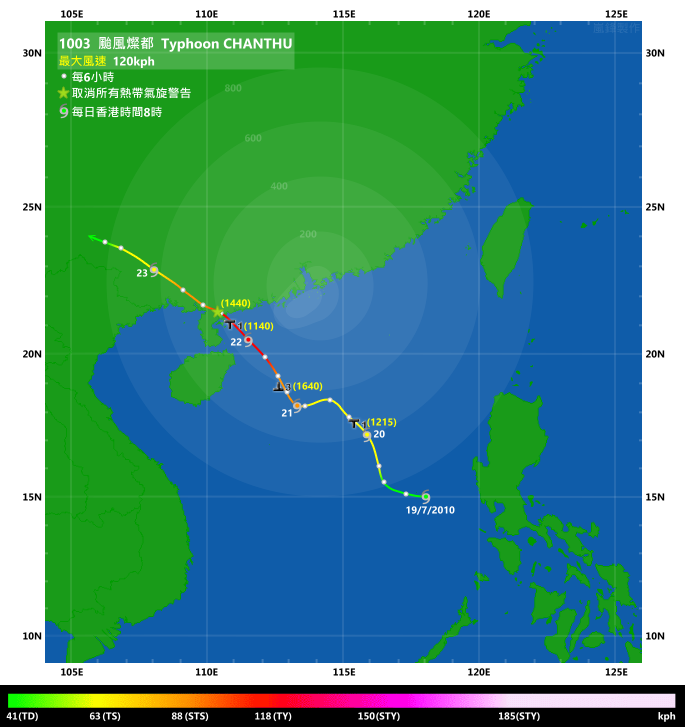
IR imagery animation 紅外線雲圖動畫:
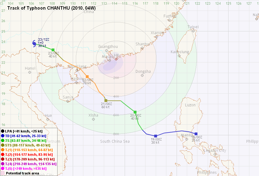
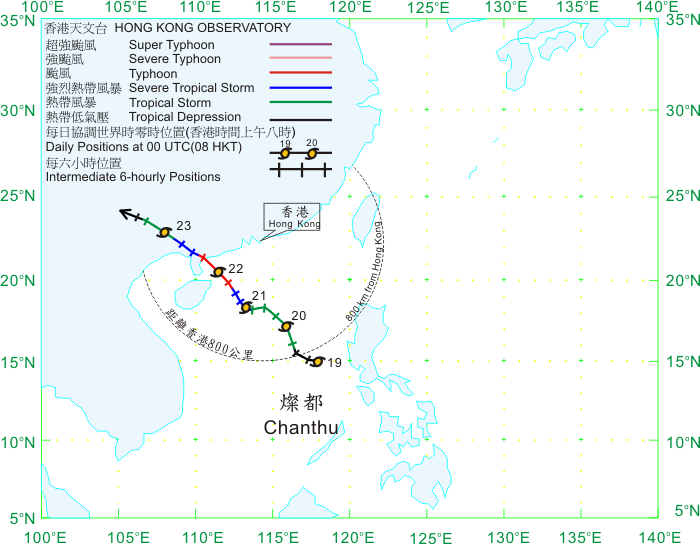
TC track from HKWW 本站的熱帶氣旋路徑圖:
TC track from HKO 天文台的熱帶氣旋路徑圖:
| Past HKWW Bulletins on CHANTHU 本站有關燦都的發佈 |
Please click here for bulletins on CHANTHU. 請按這裡。
| Storm Formation and Development 氣旋形成和發展 |
Just as tropical cyclone CONSON is dissipating in northern Vietnam, another disturbance started to consolidate near Luzon and intensified into the basin's fourth tropical depression this year in the afternoon of July 18. Unlike the situation a few days ago, wind shear in the region was very minimal by the time 04W formed, with generally favourable inflow and outflow channels. The only obstacle for intensification was its proximity to the Philippines. The subtropical ridge was once again expected to retreat soon, providing an increasingly poleward movement which would drive 04W towards central Guangdong coastal areas; this projection was once again proved wrong as the subtropical ridge continued to stay stronger than usual.
Steered towards the west, 04W quickly crossed northern Philippines and was in the South China Sea by the following day. It was upgraded by the HKO as a tropical depression at 10 HKT on July 19. 04W then decelerated due to the lack of a steering flow. Since 04W drifted quickly to the west while it traversed the Philippines, agencies shifted their tracks west, now depicting a landfall near Yangjiang instead of near or even east of Hong Kong.
04W picked up strength that day, and was upgraded to tropical storm status by the JMA at 20 HKT. The storm was named CHANTHU which was contributed by Cambodia and is the name of a type of flower. Although CHANTHU has turned to the north-northwest that night, a consistent northward move was considered unlikely and the JMA put the system towards Dianbai in its very first bulletin.
在熱帶氣旋康森於越南北部消散之際,另一股擾動於呂宋附近整固並於 7 月 18 日下午增強為本年度西北太平洋裡第四個熱帶低氣壓。04W 形成時該區的垂直風切變微弱,與康森橫過附近地區時截然不同,而輻散及輻合亦頗佳,唯一增強障礙是系統靠近菲律賓大陸。初時預報機構曾預料副熱帶高壓脊將於短期內退卻,令 04W 逐漸以偏北的路徑趨向廣東中部沿岸,但副高再次比預期強,預測路徑亦不斷西移。
04W 快速沿駛流方向向西移動並橫過菲律賓,於翌日進入南海。它於 19 日上午 10 時被香港天文台升格為熱帶低氣壓。隨著淨駛流減弱,04W 的移動速度減低。但由於 04W 已向西移了一段距離,各預報機構紛紛將預測路徑西調,由原本登陸香港附近或以東地區改為登陸陽江一帶。
04W 於當日增強,並在晚上 8 時被日本氣象廳 (JMA) 升格為熱帶風暴。04W 被命名為燦都,其名稱由柬埔寨提供,為一種花卉的名稱。雖然燦都於 19 日晚開始轉向西北偏北移動,但普遍認為此路徑難以長期維持,而 JMA 的首佈則預計燦都將登陸電白一帶。

Figure 1 - Visible light satellite imagery at 14:32 HKT, July 18
圖 1 - 7 月 18 日下午 2 時 32 分的可見光衛星雲圖

Figure 2 - Steering flow at 14 HKT, July 18
圖 2 - 7 月 18 日下午 2 時的駛流圖
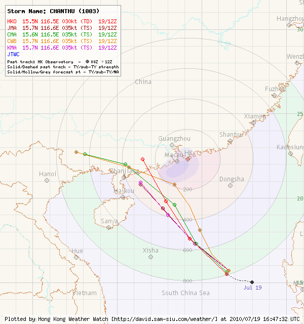
Figure 3 - Initial forecast tracks by various agencies
圖 3 - 各大氣象台的初始預報路徑
| Moving towards Southern China Coastal Areas 趨向華南沿岸 |
Although the ambient environment was very favourable for intensification, CHANTHU was consistently struggling to organize its cloud bands. Its western side was the worst part of its structure with little banding convection, and the situation did not improve in the rest of July 20. Meanwhile, although CHANTHU was moving NNW steadily, agencies continued to forecast a subsequent NW track and have started to put the track WNW as the subtropical ridge was then forecast to re-strengthen after a temporary shift in orientation that allowed a northwesterly track. Since CHANTHU had not been gaining much strength at that time, the HKO only issued the #1 Standby Signal at 12:15 HKT that day, when CHANTHU was about 550 km SSE of the territory. The weather in Hong Kong did not deteriorate at all in the rest of the day.
In an attempt to wrap its clouds, CHANTHU moved almost due west early on July 21. It successfully filled its western side with clouds and the whole system tightened. Both the JMA and HKO upgraded CHANTHU to a severe tropical storm in the small hours as its structure improved. Some southward component was observed in the morning, which might be the result of inaccurate positioning during the previous night as visible imageries were not available.
CHANTHU significantly decelerated near noon, and turned to NNW once again. The Observatory issued the #3 Strong Wind Signal at 16:40 HKT that day to warn the public of possible strong winds in the territory. Nevertheless, strong winds were observed only in offshore waters and on high ground in the following few hours, and some stations have even recorded the strongest winds before the signal was issued, probably as a result of CHANTHU tightening its structure.
雖然燦都的周邊環境非常適合氣旋增強,但它只能不斷地嘗試整合自身的環流。它的結構以其西面最為鬆散,對流亦最少,情況於 20 日維持。同時,雖然燦都穩定向西北偏北移動,各大氣象台繼續預測一個偏西北的路徑,而後段更由於預測副高將再度西伸而令路徑變為西北偏西。由於燦都並未顯著增強,天文台只於 20 日下午 12 時 15 分發出一號戒備信號,當時燦都處於香港東南偏南約 550 公里處。香港當天的天氣並未有隨一號戒備信號的發出而轉壞。
燦都在 21 日早上不斷嘗試整理其環流,導致它向偏西移動。它西面終能被雲帶填入,而整個系統亦變得緊密。隨著燦都的外觀轉好,香港天文台和日本氣象廳都於 21 日清晨時份升格燦都為強烈熱帶風暴。燦都的路徑於當天早上曾出現偏南分量,這可能是由於晚間沒有可見光雲圖輔助定位所出現的誤差。
燦都於近中午時減慢,並再度轉向西北偏北移動。天文台於下午 4 時 40 分改發三號強風信號,提醒市民港內近海平面處可能出現強風。然而,可能由於燦都環流變得更緊密,發出信號後數小時內仍只於離岸和高地錄得強風,而部分氣象站更已於信號發出之前錄得燦都影響時的最高風速。
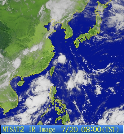
Figure 4 - Infra-red satellite imagery at 08 HKT, July 20
圖 4 - 7 月 20 日上午 8 時的紅外線衛星雲圖

Figure 5 - Steering flow at 14 HKT, July 20
圖 5 - 7 月 20 日下午 2 時的駛流圖

Figure 6 - Wind shear chart at 14 HKT, July 20
圖 6 - 7 月 20 日下午 2 時的垂直風切變分布圖


Figures 7a and 7b - Wind speeds at Cheung Chau and Waglan Island respectively on July 21
圖 7a 及 7b - 7 月 21 日長洲和橫瀾島錄得之風速


Figures 8a and 8b - Wind speeds at Cheung Chau and Waglan Island respectively on July 22
圖 8a 及 8b - 7 月 22 日長洲和橫瀾島錄得之風速
| Landfall and Dissipation 登陸與消散 |
CHANTHU continued to intensify in very good environment and headed towards the northwest that night. It finally managed to develop an eye visible in satellite imageries and was promptly upgraded to typhoon status by the JMA at 02 HKT on July 22. The HKO followed suit at 04 HKT, and CHANTHU was closest to Hong Kong at about 09 HKT that day. CHANTHU intensified further into a 70/75-knot system (by JMA/JTWC respectively) prior to landfall, and Zhanjiang felt its full fury when it made landfall at Wuchuan city at 13:45 HKT according to the CMA.
With regard to tropical cyclone signals in Hong Kong, the HKO issued the #1 Standby Signal at 11:40 HKT on July 22 to replace the Strong Wind Signal as winds were deemed not likely to reach strong force in most urban areas. The Standby Signal was then lifted at 14:40 HKT, just one hour after CHANTHU's landfall.
Within a few hours' time, CHANTHU crossed the provincial border and entered Guangxi. As it continued to dig deeper inland, it weakened rapidly and dissipated in western Guangxi on July 23.
燦都繼續於良好的環境下增強,於 21 日晚向西北移動。它終於發展出一風眼,於 22 日上午 2 時被日本氣象廳升格為颱風。香港天文台亦於上午 4 時跟隨,而燦都則於約早上 9 時最接近香港。燦都於登陸前繼續增強至 70/75 節的強度 (分別根據日本氣象廳和聯合颱風警報中心),並於當天下午 1 時 45 分左右登陸湛江吳川市。
香港方面,隨著風力開始減弱,天文台於 22 日上午 11 時 40 分改發一號戒備信號,並於燦都登陸後約 1 小時,即於下午 2 時 40 分取消所有熱帶氣旋警告信號。
燦都於幾小時後進入廣西,並急速減弱,終於在 23 日於廣西西部消散。

Figure 9 - CHANTHU about to make landfall
圖 9 - 燦都即將登陸
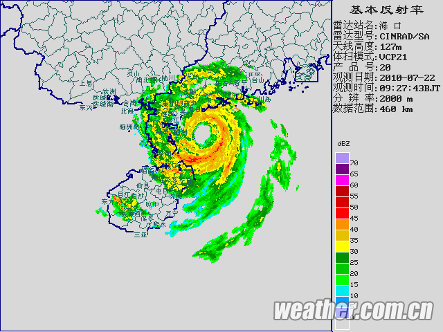
Figure 10 - RADAR image clearly shows CHANTHU's eye
圖 10 - 雷達圖像清楚顯示燦都的風眼
| Heavy Rainfall in Hong Kong 為香港帶來的大雨 |
CHANTHU's impact on Hong Kong was mainly felt as heavy rain instead of the strong winds it brought. The cyclone's southwesterly airstream converged with the southeasterly airflow from the subtropical ridge to force the uplift of air and the development of thunder-bearing clouds. Such clouds formed a rain band which affected Hong Kong in the afternoon of July 22. The SE-NW oriented rain band struck the territory and necessitated the Amber Rainstorm Warning at 16:35 that day, almost two hours after all tropical cyclone signals were cancelled. Once again it could be clearly seen that the signal was biased towards urban areas, as the northeastern parts of Hong Kong had already been raining heavily before the rainstorm signal was issued.
The Red Rainstorm Warning was issued at 17:20 HKT as more parts in Hong Kong were involved in the downpour and some convective clouds were approaching. It was quickly changed to the Black Rainstorm Warning just 10 minutes later, the first such signal since 2008. It is a rare event for a storm making landfall west of Hong Kong to necessitate the Black Rainstorm Warning (both directly and indirectly), the only occurrences in the past 10 years were tropical storm FITOW in 2001 and typhoon NEOGURI in 2008.
Apart from the rainstorm warnings, the Special Announcement on Flooding in the Northern New Territories was also issued at 17:40 HKT, warning about possible flooding there. The massive rainfall also necessitated the Landslip Warning, which was issued at 18:10 HKT. From HKO's hourly weather report issued at 18 HKT, three areas including Western Kowloon, Tsuen Wan and Kwai Tsing recorded rainfall in excess of 100 mm in the hour between 16:45 HKT and 17:45 HKT, and Tai Po, Wan Chai, Eastern Kowloon, Eastern Hong Kong Island and Sha Tin all recorded rainfall above the Black Rainstorm threshold.
As the rainband finally migrated to the east and weakened, all these rainfall-related signals were lifted in the following 12 hours.
In Hong Kong, 4 people lost their lives as a result of this rainstorm. A man was washed away by flash flood in Sha Po Tsai Tsuen in Tai Po (which was devastated in the rainstorm) while another was found immersed in rain water in his house in Sheung Shui. Meanwhile, two people drowned when the water level surged rapidly while they were fishing in Lower Shing Mun Reservoir; their bodies were only found 5 and 7 days after the incident respectively.
燦都對香港的影響以暴雨為主。它所帶來的西南氣流遇上副高西南側的東南氣流,空氣因而被提升並形成雷雨雲。由這些雨雲形成的雨帶於 7 月 22 日下午影響本港。這條雨帶為東南 - 西北向,而受其影響,天文台於下午 4 時 35 分發出黃色暴雨警告,即在熱帶氣旋警告信號除下約兩小時後。由於大雨早於暴雨警告發出前影響本港東北部地區,這次亦可以看到暴雨警告較側重市區的雨勢。
隨著雨勢加大且預計會持續,天文台於下午 5 時 20 分發出紅色暴雨警告信號,並在 10 分鐘後改為黑色,為自 2008 年來發出的首個黑雨信號。在香港以西登陸的熱帶氣旋引致黑雨較為罕見,對上 10 年的例子只有 2001 年熱帶風暴菲特和 2008 年颱風浣熊。
除暴雨警告外,天文台亦於下午 5 時 40 分發出新界北部水浸特別報告,繼而於 6 時 10 分發出山泥傾瀉警告。在天文台於下午 6 時發出的每小時天氣報告中可以看到,在 4 時 45 分至 5 時 45 分的一小時內,九龍西,荃灣和葵青區均錄得超過 100 毫米的雨量,而大埔、灣仔、九龍東、港島東區和沙田亦錄得黑雨水平的雨量。
隨著雨帶逐漸向東遷移,所有與暴雨有關的信號於其後 12 小時內解除。
在香港,這場暴雨奪去 4 人的性命。在被大雨蹂躪的大埔碗窰沙埔仔村,一名男子被洪水沖走,而另一名正在家中的男子則被發現浸在水中,送院不久後不治。另外,兩名青年在下城門水塘釣魚時被洪水沖走,其遺體分別於事發後 5 及 7 天被發現。
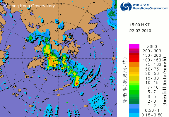
Figure 11 - The rain band that affected Hong Kong on July 22
圖 11 - 7 月 22 日影響香港的雨帶
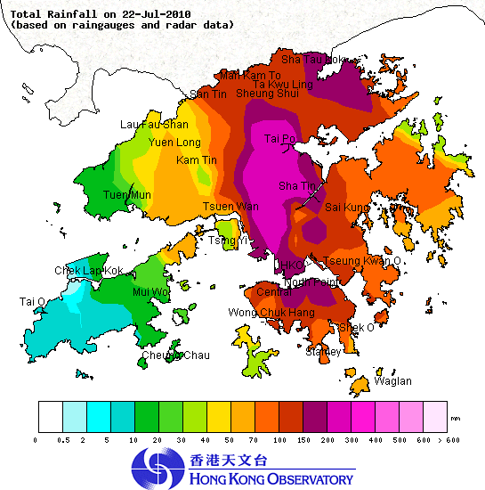
Figure 12 - Isohyet chart for July 22
圖 12 - 7 月 22 日之等雨量線圖
| Winds Recorded at Reference Stations 參考站所錄得的風速 |
| Station 風速站 |
Max. 10-min avg. wind speed 最高十分鐘平均風速 |
Beaufort classification 蒲福氏風級分類 |
| Chek Lap Kok 赤鱲角 | 51 km/h | STRONG 強風 |
| Cheung Chau 長洲 | 56 km/h | STRONG 強風 |
| Kai Tak 啟德 | 44 km/h | STRONG 強風 |
| Sai Kung 西貢 | 39 km/h | Fresh 清勁 |
| Sha Tin 沙田 | 26 km/h | Moderate 和緩 |
| Ta Kwu Ling 打鼓嶺 | 19 km/h | Moderate 和緩 |
| Tsing Yi (SHL) 青衣蜆殼油庫 | 29 km/h | Moderate 和緩 |
| Wetland Park 濕地公園 | 26 km/h | Moderate 和緩 |
| Number of stations recording at least STRONG force (force 6 - 7) winds: | 3 |
Number of stations recording at least GALE force (force 8 - 9) winds: |
0 |
| Number of stations recording at least STORM force (force 10 - 11) winds: | 0 |
| Number of stations recording HURRICANE force (force 12) winds: | 0 |
| 錄得 強風 (6 - 7 級) 或更高風速的站數: | 3 |
| 錄得 烈風 (8 - 9 級) 或更高風速的站數: | 0 |
| 錄得 暴風 (10 - 11 級) 或更高風速的站數: | 0 |
| 錄得 颶風 (12 級) 風速的站數: | 0 |
| Charts and Figures 各項數據 |
Table 1: Track data from HKWW:
表一 : 香港天氣觀測站之路徑資料
YYMMDDZZ Lat Long Wind |
Table 2: Maximum gust and 60-minute average wind speed recorded in Hong Kong from HKO:
表二 : 香港天文台公佈的各站最高 60 分鐘平均風力和陣風數據
| Station | Maximum Gust |
Maximum Hourly Mean Wind |
||||||
Direction |
Speed (km/h) |
Date/Month |
Time |
Direction |
Speed (km/h) |
Date/Month |
Time |
|
| Bluff Head (Stanley) | ESE |
59 |
22/7 |
09:29 |
ESE |
40 |
22/7 |
07:00 |
| Central Pier | E |
54 |
21/7 |
14:03 |
E |
27 |
22/7 |
03:00 |
| Cheung Chau | ESE |
68 |
21/7 |
23:35 |
SE |
52 |
22/7 |
08:00 |
| Cheung Chau Beach | E |
67 |
21/7 |
23:19 |
E |
51 |
22/7 |
08:00 |
| Cheung Sha Wan | ESE |
47 |
21/7 |
13:49 |
E |
14 |
22/7 |
08:00 |
| Green Island | ENE |
76 |
21/7 |
13:50 |
NE |
43 |
21/7 |
22:00 |
| Hong Kong International Airport | ESE |
68 |
22/7 |
08:36 |
ESE |
36 |
22/7 |
09:00 |
| Kai Tak | E |
68 |
21/7 |
13:45 |
E |
31 |
22/7 |
08:00 |
| King's Park | ESE |
65 |
21/7 |
13:48 |
ESE |
22 |
22/7 |
08:00 |
| Lau Fau Shan | S |
52 |
22/7 |
13:32 |
E |
23 |
21/7 |
11:00 |
| Ngong Ping | E |
131 |
21/7 |
22:36 |
E |
87 |
21/7 |
16:00 |
| North Point | E |
56 |
21/7 |
13:49 |
E |
25 |
21/7 |
23:00 |
| Peng Chau | SSE |
62 |
22/7 |
13:03 |
E |
36 |
21/7 |
18:00 |
| Ping Chau | SE |
43 |
21/7 |
14:32 |
ESE |
12 |
22/7 |
11:00 |
ESE |
12 |
22/7 |
13:00 |
|||||
| Sai Kung | SE |
68 |
22/7 |
09:41 |
SSE |
31 |
22/7 |
12:00 |
| Sha Chau | SSE |
72 |
22/7 |
13:06 |
SE |
45 |
22/7 |
08:00 |
| Sha Lo Wan | SE |
65 |
22/7 |
08:36 |
E |
27 |
22/7 |
07:00 |
SE |
27 |
22/7 |
09:00 |
|||||
| Sha Tin | SE |
47 |
21/7 |
14:21 |
SE |
22 |
22/7 |
08:00 |
| Shek Kong | ESE |
43 |
21/7 |
14:13 |
E |
23 |
22/7 |
02:00 |
| Star Ferry (Kowloon) | E |
67 |
21/7 |
13:50 |
E |
31 |
22/7 |
10:00 |
| Ta Kwu Ling | E |
40 |
22/7 |
04:51 |
E |
16 |
22/7 |
05:00 |
| Tai Mei Tuk | ESE |
75 |
22/7 |
09:52 |
ENE |
34 |
21/7 |
18:00 |
| Tai Mo Shan | ESE |
110 |
21/7 |
13:57 |
SE |
76 |
21/7 |
15:00 |
| Tap Mun | SE |
56 |
22/7 |
10:49 |
SE |
31 |
22/7 |
11:00 |
| Tate's Cairn | SSE |
96 |
21/7 |
13:50 |
ESE |
45 |
21/7 |
23:00 |
| Tsak Yue Wu | SSW |
38 |
22/7 |
11:49 |
ENE |
12 |
21/7 |
19:00 |
E |
12 |
22/7 |
04:00 |
|||||
| Tseung Kwan O | SE |
58 |
21/7 |
13:41 |
SE |
14 |
22/7 |
14:00 |
| Tsing Yi Shell Oil Depot | SE |
72 |
21/7 |
13:56 |
ESE |
23 |
22/7 |
13:00 |
| Tuen Mun Government Offices | ESE |
58 |
22/7 |
07:17 |
SE |
25 |
22/7 |
09:00 |
SE |
25 |
22/7 |
10:00 |
|||||
| Waglan Island | SE |
67 |
21/7 |
13:28 |
ESE |
43 |
22/7 |
08:00 |
| Wetland Park | ESE |
45 |
21/7 |
14:12 |
SE |
19 |
22/7 |
09:00 |
| Wong Chuk Hang | ENE |
54 |
21/7 |
22:09 |
E |
22 |
21/7 |
23:00 |
Table 3: Rainfall (in millimetres) contributed by CHANTHU from HKO (figures in brackets are based on incomplete hourly data):
表三 : 香港天文台公佈的各站雨量資料 (方括號內之數據由不完整之每小時資料擷取)
| Station | 20-Jul |
21-Jul |
22-Jul |
Total |
|
| Hong Kong Observatory | 0.0 |
29.6 |
182.4 |
212.0 |
|
| Cheung Chau (CCH) | 0.0 |
19.5 |
11.5 |
31.0 |
|
| Hong Kong International Airport (HKA) | 0.0 |
28.4 |
9.8 |
38.2 |
|
| N05 | Fanling | 0.0 |
23.0 |
165.5 |
188.5 |
| N13 | High Island | 0.0 |
22.5 |
75.5 |
98.0 |
| K04 | Jordan Valley | 0.0 |
[32.0] |
131.0 |
[163.0] |
| N06 | Kwai Chung | 0.0 |
21.5 |
252.5 |
274.0 |
| H12 | Mid Levels | 0.0 |
41.5 |
99.0 |
140.5 |
| H21 | Repulse Bay | 0.0 |
46.0 |
118.0 |
164.0 |
| N09 | Sha Tin | 0.0 |
44.5 |
159.0 |
203.5 |
| H19 | Shau Kei Wan | 0.0 |
27.5 |
131.5 |
159.0 |
| SEK | Shek Kong | 0.0 |
23.0 |
88.5 |
111.5 |
| K06 | So Uk Estate | 0.0 |
24.0 |
254.5 |
278.5 |
| R31 | Tai Mei Tuk | 0.0 |
38.0 |
129.0 |
167.0 |
| R21 | Tap Shek Kok | 0.0 |
27.5 |
13.0 |
40.5 |
| N17 | Tung Chung | 0.0 |
29.5 |
12.0 |
41.5 |
| R27 | Yuen Long | 0.0 |
12.0 |
46.5 |
58.5 |
Last Accessed 最近訪問日期: Sun Sep 08 2024 12:34:33 HKT
Last Modified 最近修訂日期: Mon Jul 24 2023
