
TC Watch / 熱帶氣旋 > Selected TC Review / 重要熱帶氣旋回顧 > 201003W (CONSON 康森) [Refresh 更新]
 201003W (CONSON 康森) - Profile 檔案 201003W (CONSON 康森) - Profile 檔案 |
(First draft issued on July 24, 2010; final version issued on August 4, 2010)
(初稿於 2010 年 7 月 24 日發出,最後版本於 8 月 4 日上載)
Brief profile of CONSON 康森小檔案:
| JTWC number 聯合颱風警報中心 (JTWC) 號碼 | 03W |
| International number 國際編號 | 1002 |
| Period of existence 生存時期 (JTWC) | 2010/07/11 20 HKT - 2010/07/18 02 HKT |
| Lifetime 壽命 (JTWC) | 6.25 days 日 |
| Maximum 1-minute wind (JTWC) JTWC 一分鐘平均最高中心風速 | 75 knots 節 (Category 1 Typhoon 一級颱風) |
| Minimum pressure (JTWC) JTWC 最低氣壓 | 967 hPa 百帕 |
| Highest TC signal by HKO (if applicable) 香港天文台發出最高熱帶氣旋警告信號 |
1 (Standby Signal 戒備信號) |
| Closest point of approach by HKO (if applicable) 香港天文台所示之最接近距離 (如適用) |
SSW 630 km (real-time warning 實時報告) / S 630 km (TC report 熱帶氣旋報告) |
| Time of closest approach by HKO (if applicable) 香港天文台所示之最接近時間 (如適用) |
2010/07/15 21 HKT (real-time warning 實時報告) / 20 HKT (TC report 熱帶氣旋報告) |
| Lowest pressure recorded at HKO (if applicable) 香港天文台錄得的最低氣壓 (如適用) |
1006.2 hPa 百帕 (2010/07/15 15:42 - 17:42 HKT) |
TC signals for Hong Kong & Track 香港曾經生效的熱帶氣旋警告和路徑圖:
Table 表:
| Signal 信號 |
Date and time 日期和時間 |
Distance from HK 與香港的距離 |
Predicted movement 預測移動方向和速度 |
Max. 10-min winds 中心最高十分鐘平均風速 |
 |
2010/07/15 (THU) 19:20 HKT |
S 640 km |
WNW at 20 km/h |
110 km/h (60 knots, STS) |
 |
2010/07/16 (FRI) 21:15 HKT |
SW 670 km |
NW / WNW at 20 km/h |
120 km/h (65 knots, CAT. 1 / TY) |
Figure 圖:
(Track courtesy of Lorenzo. Data from HKO. 鳴謝 Lorenzo 提供路徑圖,資料取自天文台)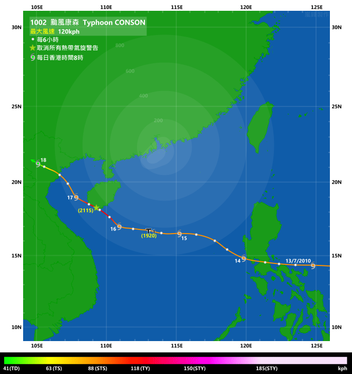
IR imagery animation 紅外線雲圖動畫:
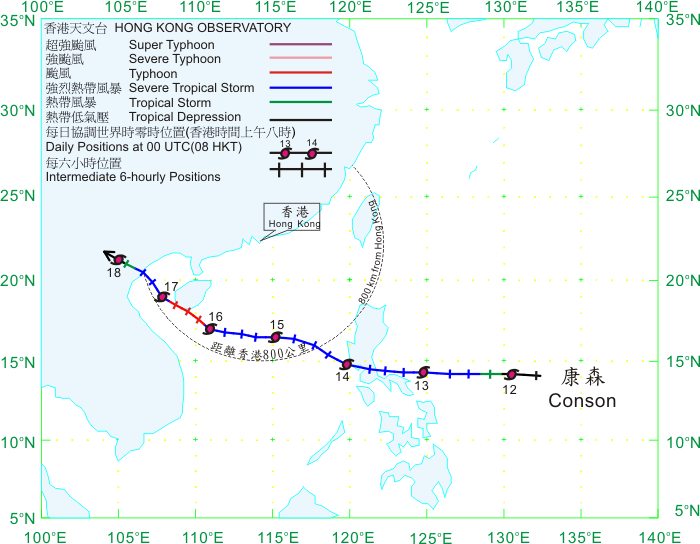
TC track from HKWW 本站的熱帶氣旋路徑圖:
TC track from HKO 天文台的熱帶氣旋路徑圖:
| Past HKWW Bulletins on CONSON 本站有關康森的發佈 |
Please click here for bulletins on CONSON. 請按這裡。
| Storm Formation and Development 氣旋形成和發展 |
The first half of 2010 saw a significantly calmer western Pacific than normal, with only one named storm forming. The region became active again when an area of disturbance intensified into a tropical depression on July 11 some 1300 km east of Manila. Since this is the third depression in this basin this year, the JTWC gave it the temporary number 03W. In the first report issued by the JTWC, 03W was expected to move WNW towards the Luzon terrain, and turn gradually to the north with a weakening trend. However, the subtropical ridge remained so strong in the following days that such scenario never realized.
03W was a small cyclone, and it picked up strength rapidly in a generally favourable environment with low shear and very high sea surface temperatures. Skipping their usual tropical cyclone gale warning, the JMA directly upgraded the depression into tropical storm status at 08 HKT on July 12. The cyclone was named CONSON, which is a sightseeing spot in Haihung province of the contributing country, Vietnam. CONSON sped westward while strengthening itself in the next two days.
By the time it reached the eastern coast of Manila, it had already been upgraded into a typhoon by the JTWC while a severe tropical storm by other agencies which use the 10-minute average wind standard. Due to the increasing vertical wind shear, the cyclone lost its symmetry with its northern side almost void of banding clouds. CONSON made landfall east of Manila in the small hours of July 14 with relatively flat land, avoiding the mountainous northern Luzon as predicted earlier. Nevertheless, land interaction and the temporary lack of moisture caused CONSON to weaken in the next 12 hours. Since the steering force from the subtropical ridge to the north was still strong, CONSON did not spend much time on land, and it entered the South China Sea in the morning of July 14. About 80 people were killed and another 74 went missing in the Philippines during CONSON's visit.
西北太平洋於本年上半年頗為平靜,只得一個被命名的熱帶氣旋出現。該區隨著一個在馬尼拉東面約 1300 公里的擾動於 7 月 11 日增強為熱帶低氣壓而再度變得活躍。由於該氣旋為本年西北太平洋之第三個熱帶低氣壓,JTWC 給予臨時編號 03W。JTWC 的首佈預計 03W 向西北偏西移動,趨向呂宋中北部,然後逐漸轉向北行並減弱,但由於副熱帶高壓脊呈現強勢,這個預測最終不能實現。
03W 為一小型氣旋,它於低垂直風切變和高水溫的良好環境下快速增強。日本氣象廳 (JMA) 甚至略去熱帶氣旋烈風警告而直接於 12 日上午 8 時升格 03W 至熱帶風暴強度,並將其命名為康森。康森為名稱提供者越南之海紅省的一個風景區。康森於其後兩日急速西移,並逐步增強。
JTWC 於康森到達馬尼拉東部沿岸前已把其升格為颱風,而其他使用 10 分鐘平均風速的氣象台則把它定為強烈熱帶風暴。由於該區垂直風切變增加,康森對流變得不對稱,北部幾乎沒有旋轉雲帶。康森於 14 日凌晨登陸馬尼拉以東地區。該區地勢相對較為平坦,而康森則避過之前預測的登陸地點呂宋中北部。雖然如此,由於地形影響及較低水氣供應,康森於未來 12 小時減弱。與此同時,康森以北的副熱帶高壓脊仍然強勁,因而縮短康森於菲律賓逗留的時間。康森於 14 日早上進入南中國海。在康森橫掃菲律賓期間,共造成約 80 人死亡,74 人失蹤。

Figure 1 - Visible light satellite imagery at 11 HKT, July 12
圖 1 - 7 月 12 日上午 11 時的可見光衛星雲圖
Figure 2 - Initial forecast tracks for various agencies
圖 2 - 各大機構初始預測圖

Figure 3 - Vertical wind shear map at 14 HKT, July 13.
圖 3 - 7 月 14 日下午 2 時的垂直風切變分布圖
| Entering the South China Sea 進入南中國海 |
Wind shear was still strong by the time CONSON entered the South China Sea. Together with the lack of upper-level divergence to the north of the cyclone, CONSON's convective clouds were confined to its southern periphery. With the abundant supply of moisture from the southwesterly airstream, CONSON expanded in size and clouds covered most of the central South China Sea. Agencies adjusted CONSON's strength downward to a minimal severe tropical storm as its low-level circulation centre was partially exposed on July 14. They also adjusted their predicted tracks westward, from a landfall at western Guangdong to Hainan, as CONSON continuously drifted to the west. The subtropical ridge, meanwhile, showed no signs of retreating. A rapid turn to the northwest was deemed unlikely.
The magnitude of vertical wind shear in the northern South China Sea decreased on the following day. CONSON was once again able to wrap its clouds to its north and covered its low-level circulation centre again. Although it moved northwestwards temporarily on July 14, it quickly resumed its westward movement on July 15. CONSON strengthened duing that day, and the Hong Kong Observatory finally issued the #1 Standby Signal at 19:20 HKT that day when CONSON was 640 km south of the territory. It was widely speculated that the issuance of the Signal was to warn the public that strong winds might be observed in offshore areas and on high ground in the coming hours, which accounted for the late issuance of the Signal.
The JTWC upgraded CONSON into a typhoon again at 20 HKT on July 15 as it continued to strengthen. Other agencies followed on the next day as an eye could be seen on satellite images. CONSON started to pick up latitude and briefly made landfall at Sanya near 20 HKT on July 16. Pressure there dropped significantly, and CONSON skirted the southwestern edge of Hainan that night. Seeing a reduced threat, the HKO lifted the Standby Signal at 21:15 HKT on July 16.
康森於進入南海之時風切仍強勁。同時,由於康森北方高空輻散差劣,康森的對流雲層幾乎全部集中在其南端。受惠於西南氣流帶來的濕潤空氣,康森的雲帶逐步擴闊,南海中部幾乎全被康森的雲團覆蓋。隨著康森的低層環流中心部份外露而路徑持續偏西,各機構紛紛於 14 日下調其強度至強烈熱帶風暴下限,並多次西調其路徑,由登陸廣東西部調整至海南島。同時,副熱帶高壓脊並沒有絲毫快速東退的跡象,康森急轉西北的機會變得非常小。
翌日,南海的垂直風切變開始減低。康森再度捲起雲團至其北面,低層環流中心亦能被覆蓋。雖然康森曾於 14 日短暫向西北移動,它很快於 15 日回復偏西之路徑。由於康森增強,天文台終於在 15 日下午 7 時 20 分發出一號戒備信號,當時康森於香港以南約 640 公里。由於發出警告時間頗遲,外界一般估計一號信號所包含的影響只為離岸和高地吹強風,而預警時間也較以前縮短。
JTWC 於 15 日下午 8 時的發佈中再度把康森升格為颱風。其他機構於翌日跟隨,當時康森開始發展出一風眼並於衛星圖上可見。康森的緯度亦開始增加,於 16 日下午 8 時左右短暫登陸三亞市,該地氣壓大幅下降。康森於當晚掠過海南島的西南端,而隨著威脅逐漸減低,天文台於當晚 9 時 15 分解除一號戒備信號。


Figure 4a and 4b - Satellite images of CONSON at 10 HKT, July 13 and 21 HKT, July 14 respectively
圖 4a 及 4b - 7 月 13 日上午 10 時和翌日下午 9 時之衛星雲圖


Figure 5a and 5b - Steering charts at 14 HKT, July 12 and 15 respectively
圖 5a 及 5b - 7 月 12 和 15 日下午 2 時之駛流圖

Figure 6 - Radar image at 18:30 HKT, July 16. CONSON's eye can be seen approaching Sanya
圖 6 - 7 月 16 日下午 6 時 30 分之雷達圖。康森的風眼正逼近三亞
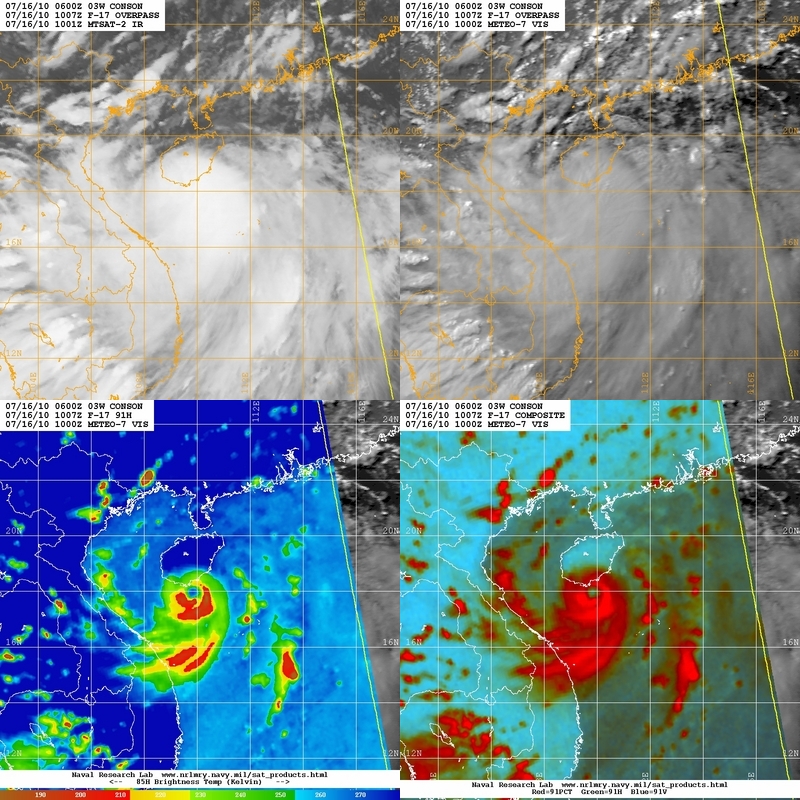
Figure 7 - Multi-channel map depicting CONSON's structure
圖 7 - 多頻道圖像顯示康森的結構
| Landfall and Dissipation 登陸與消散 |
CONSON entered the Gulf of Tonkin on July 17. It moved northwestwards and started to weaken due to increasing wind shear. The circulation centre was exposed again and the storm was downgraded into a severe tropical storm prior to landfall. CONSON made its third and final landfall in northern Vietnam at about 20 HKT that night, and rapidly weakened into an area of low pressure the next morning.
康森於 17 日進入北部灣並向西北移動。由於垂直風切變增加至偏強水平,康森開始減弱,低層環流中心再度外露。它減弱為強烈熱帶風暴,並於當晚約 8 時登陸越南北部。進入內陸後,康森急速減弱,並於 18 日早上消散。
| Winds Recorded at Reference Stations 參考站所錄得的風速 |
(Except for special cases, this section is not available for cyclones that only necessitated the Standby Signal 除非特別情況,否則此部只當氣旋令天文台發出三號或更高信號時提供)
| Charts and Figures 各項數據 |
Table 1: Track data from HKWW:
表一 : 香港天氣觀測站之路徑資料
YYMMDDZZ Lat Long Wind |
Table 2: Maximum gust and hourly average wind speed recorded in Hong Kong from HKO:
表二 : 香港天文台公佈的各站最高每小時平均風力和陣風數據
| Station | Maximum Gust |
Maximum Hourly Wind |
||||||
Direction |
Speed (km/h) |
Date/Month |
Time |
Direction |
Speed (km/h) |
Date/Month |
Time |
|
| Bluff Head (Stanley) | ESE |
59 |
15/7 |
22:23 |
SE |
31 |
16/7 |
05:00 |
| Central Pier | SE |
51 |
15/7 |
22:53 |
E |
31 |
16/7 |
12:00 |
| Cheung Chau | ESE
|
81
|
16/7
|
12:12
|
ESE |
40 |
16/7 |
12:00 |
ESE |
40 |
16/7 |
13:00 |
|||||
| Cheung Chau Beach | ESE |
88 |
16/7 |
12:12 |
E |
34 |
16/7 |
12:00 |
| Cheung Sha Wan | ESE
|
49
|
16/7
|
14:16
|
ESE |
14 |
16/7 |
12:00 |
ESE |
14 |
16/7 |
13:00 |
|||||
| Green Island | SE |
85 |
16/7 |
14:10 |
ENE |
34 |
16/7 |
13:00 |
| Hong Kong International Airport | SE |
65 |
16/7 |
12:29 |
SE |
38 |
16/7 |
12:00 |
| Kai Tak | ESE |
59 |
16/7 |
17:57 |
ESE |
27 |
16/7 |
13:00 |
| King's Park | ESE |
43 |
16/7 |
12:49 |
ESE |
20 |
15/7 |
23:00 |
| Lau Fau Shan | SE |
72 |
16/7 |
14:41 |
SE |
23 |
16/7 |
15:00 |
| Ngong Ping | E |
142 |
15/7 |
22:50 |
E |
75 |
15/7 |
23:00 |
| North Point | E |
47 |
16/7 |
12:03 |
E |
27 |
16/7 |
13:00 |
| Peng Chau | S |
58 |
16/7 |
14:11 |
ESE |
23 |
15/7 |
23:00 |
| Ping Chau | ESE |
45 |
15/7 |
23:25 |
SE |
9 |
16/7 |
19:00 |
| Sai Kung | SE |
54 |
16/7 |
14:19 |
SSE |
27 |
16/7 |
00:00 |
| Sha Chau | SSE |
70 |
16/7 |
14:25 |
SE |
34 |
16/7 |
13:00 |
| Sha Lo Wan | SE |
70 |
15/7 |
22:56 |
E |
25 |
16/7 |
11:00 |
| Sha Tin | SSE |
47 |
15/7 |
23:23 |
SSE |
14 |
16/7 |
13:00 |
| Shek Kong | E |
49 |
16/7 |
10:35 |
E |
19 |
16/7 |
13:00 |
| Star Ferry (Kowloon) | SSE |
62 |
16/7 |
18:02 |
E |
30 |
16/7 |
12:00 |
| Ta Kwu Ling | E |
45 |
16/7 |
14:00 |
E |
19 |
16/7 |
14:00 |
| Tai Mei Tuk | SE |
68 |
16/7 |
14:32 |
E |
31 |
16/7 |
14:00 |
| Tai Mo Shan | SE |
79 |
16/7 |
00:07 |
SE |
58 |
16/7 |
01:00 |
| Tap Mun | ESE |
58 |
15/7 |
23:22 |
SE |
23 |
16/7 |
00:00 |
| Tate's Cairn | S |
68 |
16/7 |
18:11 |
SE |
38 |
15/7 |
23:00 |
SSW |
68 |
16/7 |
18:16 |
|||||
| Tsak Yue Wu | SSW |
31 |
16/7 |
18:25 |
SSE |
9 |
16/7 |
13:00 |
| Tseung Kwan O | SE |
43 |
16/7 |
14:11 |
SE |
13 |
16/7 |
11:00 |
| Tsing Yi Shell Oil Depot | SE |
56 |
15/7 |
23:04 |
SE |
23 |
16/7 |
13:00 |
| Tuen Mun Government Offices | S |
75 |
16/7 |
14:27 |
SE |
22 |
16/7 |
15:00 |
| Waglan Island | SE |
85 |
15/7 |
22:16 |
SE |
40 |
15/7 |
23:00 |
| Wetland Park | SSE |
49 |
16/7 |
14:39 |
ESE |
20 |
16/7 |
12:00 |
| Wong Chuk Hang | SE
|
58
|
16/7
|
04:30
|
E |
19 |
15/7 |
23:00 |
ESE |
19 |
16/7 |
12:00 |
|||||
Table 3: Rainfall (in millimetres) contributed by CONSON from HKO (figures in brackets are based on incomplete hourly data):
表三 : 香港天文台公佈的各站雨量資料 (方括號內之數據由不完整之每小時資料擷取)
| Station | 15-Jul |
16-Jul |
Total |
|
| Hong Kong Observatory | 8.4 |
17.8 |
26.2 |
|
| Cheung Chau (CCH) | 3.5 |
17.5 |
21.0 |
|
| Hong Kong International Airport (HKA) | 1.1 |
16.9 |
18.0 |
|
| N05 | Fanling | 16.5 |
[7.0] |
[23.5] |
| N13 | High Island | 10.5 |
10.5 |
21.0 |
| K04 | Jordan Valley | 11.0 |
13.5 |
24.5 |
| N06 | Kwai Chung | 17.0 |
16.0 |
33.0 |
| H12 | Mid Levels | 21.5 |
27.0 |
48.5 |
| H21 | Repulse Bay | 6.0 |
15.0 |
21.0 |
| SHA | Sha Tin | 6.5 |
16.5 |
23.0 |
| H19 | Shau Kei Wan | 5.0 |
9.0 |
14.0 |
| SEK | Shek Kong | 2.5 |
21.5 |
24.0 |
| K06 | So Uk Estate | 14.5 |
13.5 |
28.0 |
| R31 | Tai Mei Tuk | [3.0] |
12.5 |
[15.5] |
| R21 | Tap Shek Kok | 9.0 |
15.5 |
24.5 |
| N17 | Tung Chung | 12.0 |
16.0 |
28.0 |
| R27 | Yuen Long | 2.0 |
22.0 |
24.0 |
Last Accessed 最近訪問日期: Sun Sep 08 2024 12:42:30 HKT
Last Modified 最近修訂日期: Mon Jul 24 2023
