
TC Watch / 熱帶氣旋 > Selected TC Review / 重要熱帶氣旋回顧 > 200926W (NIDA 妮妲) [Refresh 更新]
 200926W (NIDA 妮妲) - Profile 檔案 200926W (NIDA 妮妲) - Profile 檔案 |
(Iissued on December 27th, 2009)
(於 2009 年 12 月 27 日發出)
Brief profile of NIDA 妮妲小檔案:
| JTWC number 聯合颱風警報中心 (JTWC) 號碼 | 26W |
| International number 國際編號 | 0922 |
| Period of existence 生存時期 (JTWC) | 22 November, 2009 08 HKT to 3 December, 2009 08 HKT |
| Lifetime 壽命 (JTWC) | 11.00 days 日 |
| Maximum 1-minute wind (JTWC) JTWC 一分鐘平均最高中心風速 | 160 knots 節 (Category 5 Super Typhoon 五級超級颱風) |
| Minimum pressure (JTWC) JTWC 最低氣壓 | 903 hPa 百帕 |
| Highest TC signal by HKO (if applicable) 香港天文台發出最高熱帶氣旋警告信號 |
N/A 不適用 |
| Closest point of approach by HKO (if applicable) 香港天文台所示之最接近距離 (如適用) |
N/A 不適用 |
| Time of closest approach by HKO (if applicable) 香港天文台所示之最接近時間 (如適用) |
N/A 不適用 |
| Lowest pressure recorded at HKO (if applicable) 香港天文台錄得的最低氣壓 (如適用) |
N/A 不適用 |
TC track from HKWW 本站的熱帶氣旋路徑圖:

| Past HKWW Bulletins on NIDA 本站有關妮妲的發佈 |
Please click here for bulletins on NIDA. 請按這裡。
| Storm Summary 氣旋摘要 |
NIDA is the third category five super typhoon in the northwest Pacific this year and is the most intense tropical cyclone worldwide in 2009, reaching an intensity of 160 knots (295 km/h) on November 26.
An area of active low pressure acquired spiraling characteristics in late November, and the JTWC issued a tropical cyclone formation alert for this disturbance at 14 HKT on November 21, when it was some 300 km WSW of Chuuk. This disturbance further strengthened that night, and the first tropical cyclone bulletin for this system was issued at 08 HKT the next day. The storm was designated 26W by the JTWC as it became the 26th tropical depression of the year. Initial forecasts called for a persistent NW track along the southwestern periphery of the subtropical ridge, but numerical models had very different forecasts about 26W's track as it reached higher latitudes.
26W's spiraling bands became more prominent during the day. The JMA upgraded it into tropical storm status at 20 HKT on November 23, naming it NIDA. The name was contributed by Thailand and is a woman's name used there.
NIDA initially moved rather west at a latitude of below 10°N. It consolidated at a rapid rate and attained typhoon status (in JTWC standards) by 14 HKT the next day. Due to the favourable conditions ahead of the cyclone, it was then generally believed that NIDA could reach at least category 4 status later. NIDA maintained its intensifying trend and it reached a strength of 100 knots (185 km/h) by dawn on November 25. Responding to the ridge's orientation, NIDA turned to move northwest. A clear eye was discernible on satellite imageries and a symmetric central dense overcast could be seen. NIDA's eyewall cloud top temperatures also plummeted to very low levels.
In the next twelve hours, NIDA intensified at a rate of 25 knots (45 km/h) per 6 hours and reached 150 knots (280 km/h) by 20 HKT that day, which belongs to category five on the Saffir-Simpson Scale. The JMA, using ten-minute average wind speeds, also deemed NIDA the strongest typhoon this year by assigning a strength of 115 knots (215 km/h). For prolonged periods NIDA's eyewall has seen cloud top temperatures of below -80 degrees Celsius, which accounted for its intensity. However, microwave images showed that NIDA's low-level structure may not be that complete.
Nevertheless, its extremely low temperatures contributed to a T-number of 7.5, which was 3.0 higher than the number one day before and only 0.5 below that of a "perfect storm" in Dvorak analysis. The JTWC then upgraded NIDA to a 160-knot (295 km/h) super typhoon at 02 HKT on November 26. This equalled the intensity of super typhoons JOAN, IVAN and PAKA in 1997 and was the highest in this basin since then, and also made NIDA the strongest tropical cyclone globally in 2009, just 5 knots (10 km/h) above hurricane RICK's 155 knots in the east Pacific a month ago.
Meanwhile, serious divergence appeared in NIDA's forecast track, with some model guidance showing a steep recurvature and some putting NIDA in a pressure col and drifting westward slowly. As NIDA moved further north, it turned poleward and weakened slightly, albeit retaining super typhoon strength. The western ridge strengthened at this time and this rendered NIDA almost motionless on November 28. It also picked up some strength, possibly as a result of improved divergence. NIDA became a category five storm for the second time, peaking at 150 knots. However moving slowly took its toll on NIDA's strength as cold water was continuously pushed upward. After staying at super typhoon strength for a continuous three and a half days, NIDA weakened rapidly on November 29 and a double eyewall feature appeared.
Still embedded in the pressure col, NIDA turned northwestward on November 30, crossing 20°N latitude while weakening into a category one typhoon. Cooler seas, drier air and stronger vertical wind shear acted together, causing NIDA to lose strength significantly on the following two days.
Without recurvature materializing, NIDA dissipated and lost all its convections on December 3, and both the JMA and JTWC stopped issuing warning bulletins at 08 HKT.
妮妲為本年度西北太平洋第三個五級超級颱風,並為本年度全球最強的熱帶氣旋,於 11 月 26 日達到風速 160 節 (每小時 295 公里) 的強度。
11 月底,於楚克島附近的一個活躍低壓區開始呈現旋捲性,聯合颱風警報中心 (JTWC) 於 21 日下午 2 時發出熱帶氣旋形成警報。此擾動於當晚逐漸增強,而 JTWC 則於翌日上午 8 時對其作出第一次發佈。該氣旋的臨時編號為 26W。初時預報大多指出 26W 將沿副熱帶高壓脊的西南面持續向西北移動,但於 26W 到達較高位置後則出現分歧。
26W 的螺旋雲帶於 22 日變得更為明顯,而日本氣象廳 (JMA) 於當晚 8 時將其升格為熱帶風暴,並把它命名為妮妲。此名稱由泰國提供,為一女性名字。
妮妲初時於北緯 10 度以南向偏西移動。它整固速度很快,於 23 日下午 2 時已達颱風標準 (JTWC)。由於妮妲西北面環境頗佳,當時一般預料妮妲可於稍後增強至最少四級颱風強度。妮妲繼續其增強趨勢,於 25 日清晨增強至 100 節 (每小時 185 公里風速)。妮妲受高壓脊影響而開始轉向西北移動,並於衛星雲圖中展現出清晰的風眼和對稱的中央密集雲團區。妮妲的雲頂溫度亦急降至極低水平。
在接下來的 12 小時,妮妲以每 6 小時 25 節 (每小時 45 公里) 的速度增強,於晚上 8 時的強度為 150 節 (每小時 280 公里),達到五級颱風水平。使用 10 分鐘平均風速標準的 JMA 亦給予 115 節 (每小時 215 公里) 的強度,令妮妲成為本年度西北太平洋上最猛烈的颱風。妮妲眼牆雲頂溫度長期維持於攝氏 -80 度以下,因此各氣象機構均給予妮妲不俗的強度,但由微波影像可以看到妮妲的低層結構未必如想像中那麼完整。
儘管如此,極低的雲頂溫度令 T 號碼躍升至 7.5,比一天前高出 3.0,而離極限的 T8.0 也只差 0.5。JTWC 於 11 月 26 日上午 2 時把妮妲的強度進一步提升至 160 節 (每小時 295 公里),為繼 1997 年颱風鍾茵、艾雲和 PAKA 後首個達到該強度的西北太平洋熱帶氣旋,亦令妮妲成為本年全球最強的颱風,風速僅比一個月前出現於東太平洋的颶風 RICK 高出 5 節。
與此同時,模式對於妮妲的預測移動方向及速度出現重大分歧;部分模式認為妮妲將急速轉向並切入西風帶,但亦有數值模式預計妮妲將於鞍場中向西緩慢移動。隨著妮妲向北移,它轉為向偏北方向移動,且稍為減弱,但仍然維持超級颱風水平。妮妲西面的副熱帶高壓脊於這時增強,令妮妲於 28 日停滯不前。它亦可能受較佳輻散影響而再度增強為五級超級颱風,這次巔峰為 150 節 (每小時 280 公里)。可是,由於妮妲移動緩慢引致冷水上翻,它不久後開始減弱。妮妲於 29 日急速減弱,並出現雙重眼壁。妮妲共連續處於超級颱風強度達三天半之久。
妮妲於 11 月 30 日轉向西北移動,越過 20 度緯線,並減弱為一級颱風。較冷的海水,乾燥的空氣和逐漸增強的垂直風切變共同令妮妲於未來兩天繼續減弱。
妮妲的對流於 12 月 3 日完全消失,最終於沒有轉向東北的情況下消散。JMA 和 JTWC 均於當天早上 8 時對其作出最後發佈。
| Figures 圖片 |

Figure 1 - Visible imagery at 11:01 HKT on November 22
圖 1 - 11 月 22 日上午 11 時 01 分之可見光雲圖

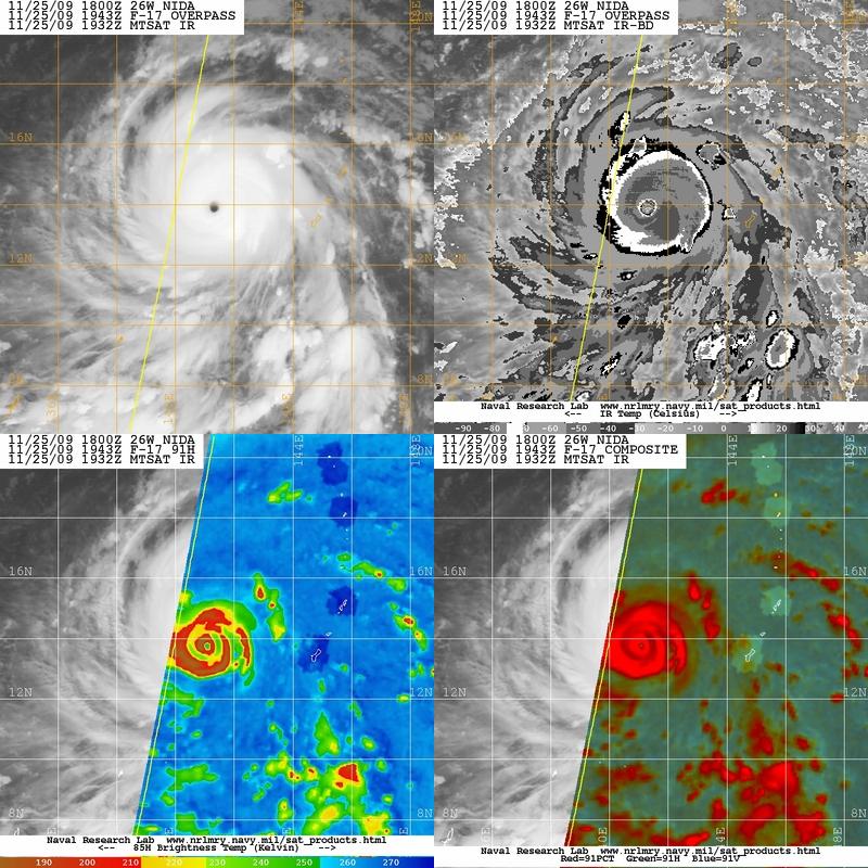
Figure 2 - Colour-enhanced IR imagery at 19:32 HKT on November 25. The yellow patch around NIDA's eye indicates that the cloud-top temperatures were below -80°C at that moment.
圖 2 - 11 月 25 日下午 7 時 32 分之色調強化紅外線衛星雲圖。風眼附近的黃區表示該區雲頂溫度低於 -80 度。
Figures 3 - NIDA at peak intensity
圖 3 - 妮妲接近巔峰強度時的圖片

Figure 4 - JTWC's forecast map at 02 HKT on November 26
圖 4 - JTWC 於 11 月 26 日上午 2 時之預測圖

Figure 5 - Calculated wind field at 08 HKT on November 26
圖 5 - 於 11 月 26 日上午 8 時所計算出的風場圖

Figures 6- Forecast tracks from different official agencies
圖 6 - 各官方氣象台預測之路徑圖

Figure 7 - Steering map at 14 HKT on November 29
圖 7 - 11 月 29 日下午 2 時之駛流圖

Figure 8 - NIDA near dissipation
圖 8 - 即將消散的妮妲
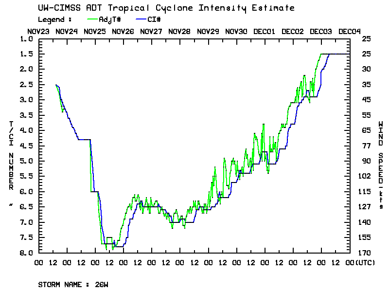
Figure 9 - NIDA's T number time series
圖 9 - 妮妲的 T 號碼時間序列
| Other Data 其他數據 |
Table 1: Track data from HKWW:
表一 : 香港天氣觀測站之路徑資料
| YYMMDDZZ Lat Long Wind 09112200 067N1489E 025 09112206 072N1486E 030 09112212 074N1481E 030 09112218 075N1482E 030 09112300 079N1483E 035 09112306 083N1478E 035 09112312 088N1471E 040 09112318 088N1464E 045 09112400 088N1458E 050 09112406 088N1455E 060 09112412 092N1450E 060 09112418 098N1444E 065 09112500 106N1438E 095 09112506 116N1430E 125 09112512 126N1422E 150 09112518 136N1414E 160 09112600 145N1407E 150 09112606 152N1400E 145 09112612 158N1397E 145 09112618 163N1393E 135 09112700 169N1392E 130 09112706 178N1392E 130 09112712 183N1390E 130 09112718 187N1390E 145 09112800 190N1390E 145 09112806 191N1393E 135 09112812 190N1393E 130 09112818 191N1394E 125 09112900 193N1394E 120 09112906 195N1393E 115 09112912 195N1393E 115 09112918 195N1394E 110 09113000 195N1393E 100 09113006 197N1391E 095 09113012 200N1389E 090 09113018 200N1384E 080 09120100 202N1381E 075 09120106 205N1378E 075 09120112 207N1376E 070 09120118 209N1375E 065 09120200 211N1373E 065 09120206 211N1358E 055 09120212 211N1348E 050 09120218 217N1343E 040 09120300 218N1342E 030 |
Table 2: Track data from JTWC:
表二 : 聯合颱風警報中心之路徑資料
ID Name YYMMDD ZZZZ Lat Long Basin Wind Pres 26W NIDA 091203 0600 22.1N 134.4E WPAC 20 1007 |
Last Accessed 最近訪問日期: Sun Sep 08 2024 12:38:16 HKT
Last Modified 最近修訂日期: Mon Jul 24 2023
