
TC Watch / 熱帶氣旋 > Selected TC Review / 重要熱帶氣旋回顧 > 200920W (MELOR 茉莉) [Refresh 更新]
 200920W (MELOR 茉莉) - Profile 檔案 200920W (MELOR 茉莉) - Profile 檔案 |
(Iissued on October 16th, 2009)
(於 2009 年 10 月 16 日發出)
Brief profile of MELOR 茉莉小檔案:
| JTWC number 聯合颱風警報中心 (JTWC) 號碼 | 20W |
| International number 國際編號 | 0918 |
| Period of existence 生存時期 (JTWC) | 29 September, 2009 14 HKT to 8 October, 2009 20 HKT |
| Lifetime 壽命 (JTWC) | 9.25 days 日 |
| Maximum 1-minute wind (JTWC) JTWC 一分鐘平均最高中心風速 | 140 knots 節 (Category 5 Super Typhoon 五級超級颱風) |
| Minimum pressure (JTWC) JTWC 最低氣壓 | 918 hPa 百帕 |
| Highest TC signal by HKO (if applicable) 香港天文台發出最高熱帶氣旋警告信號 |
N/A 不適用 |
| Closest point of approach by HKO (if applicable) 香港天文台所示之最接近距離 (如適用) |
N/A 不適用 |
| Time of closest approach by HKO (if applicable) 香港天文台所示之最接近時間 (如適用) |
N/A 不適用 |
| Lowest pressure recorded at HKO (if applicable) 香港天文台錄得的最低氣壓 (如適用) |
N/A 不適用 |
TC track from HKWW 本站的熱帶氣旋路徑圖:
| Past HKWW Bulletins on MELOR 本站有關茉莉的發佈 |
Please click here for bulletins on MELOR. 請按這裡。
| Storm Summary 氣旋摘要 |
MELOR is the second category 5 super typhoon in 2009.
After 18W and 19W (PARMA), MELOR was the third storm formed within the intertropical convergence zone which became active in late September. The JTWC issued the tropical cyclone formation alert at 02 HKT on September 29 when the disturbance was situated east of 160°E. This disturbance quickly consolidated and tropical depression status was reached 12 hours later, at 14 HKT on the same day. The JTWC numbered it 20W, and initial forecasts called for a very close approach to Saipan as a minimal typhoon.
Due to the very stable subtropical ridge, 20W travelled WNW to NW at a modest pace. The JMA upgraded 20W into a tropical storm 6 hours later, naming it MELOR. This name was contributed by Malaysia, meaning jasmine. MELOR developed at about climatological rate, staying as a tropical storm for slightly more than one day and was upgraded as a severe tropical storm by the JMA at 02 HKT on October 1. MELOR was at that time situated at 13.0°N 153.5°E.
MELOR decelerated on October 1 while continued to strengthen. Both the JMA and the JTWC declared MELOR a typhoon at 08 HKT that day as an eye has developed and was discernible on visible imagery. MELOR started to develop a central dense overcast (CDO) around its eye, and cloud top temperatures within the eyewall gradually decreased. MELOR intensified at a much faster rate during daytime on October 1; the JTWC revised MELOR's intensity upward to 105 knots (194 km/h) in just 6 hours' time, and the JMA assessed it as a 80-knot system (148 km/h). The JMA later adjusted MELOR's strength to 95 knots (176 km/h) as it continued to develop.
MELOR picked up speed again on October 2, while its intensity remained stable on that day. It also started to move WNW after moving west for the whole of October 1. Intensification continued on October 3, with its CDO becoming much rounder and wider, and its eye becoming clearer. The JTWC upgraded MELOR into a 130-knot (241 km/h) super typhoon at 02 HKT on October 4 [The intensity was estimated to be 125 knots (232 km/h) in live warnings, which was revised upward later on], and category 5 status was reached 6 hours later. Initially the JTWC estimated that MELOR had reached 145 knots (269 km/h), but was reduced to 140 knots (259 km/h) in post-analysis. It turned out that MELOR had just passed less than 150 km north of Saipan.
Meanwhile, the JMA upgraded MELOR's strength to 100, 105 and 110 knots (185, 194 and 204 km/h) at 02, 08 and 20 HKT on October 4 respectively. MELOR's structure was symmetric and was showing a rather large eye on October 4 and October 5.
A weakness developed within the ridge and MELOR tracked increasingly poleward since October 5. After staying as a category 5 cyclone for 36 hours, it weakened slightly back into a category 4 storm at 20 HKT on that day. Although MELOR showed a normal recurving track due to strong steering, it was intense and large enough to affect the movement of the nearby PARMA which was lingering at Luzon Strait at that moment. The Fujiwhara effect between super typhoon MELOR and severe tropical storm PARMA led to anticlockwise motion about the centroid of the system, and PARMA was pushed southeastward on October 6 to make landfall at Luzon for the second time.
Due to less favourable environments MELOR started its weakening trend from October 5. As a result MELOR underwent eyewall replacement cycles and double eyewall feature was observed on October 5 and October 6. It crossed the ridge axis at about 25°N at about 23 HKT on October 6; its strength was evaluated at about 100 knots (185 km/h) by the JTWC and 85 knots (157 km/h) by the JMA. MELOR then turned north-northeast, passing some 300 km (160 NM) east of Okinawa. Its eye became partially cloud-filled on IR images, but maintained at 85 knots as stated in JMA bulletins.
MELOR made landfall in Southern Honshu in the small hours on October 8, becoming the first storm to make landfall in Japan since typhoon FITOW in September 2007. It passed just 30 km (15 NM) away from Nagoya at about 05 HKT on that day, and then swept across central Japan from south to east. It weakened as a severe tropical storm at 08 HKT when it was less than 100 km (55 NM) from Tokyo, and later emerged from eastern Japan at 14 HKT.
After returning to sea, MELOR continued to track northeastward and gradually lost its tropical characteristics. It became an extratropical cyclone one day later at about 220 km (120 NM) south of Urup, Russia.
茉莉為 2009 年第二個五級超級颱風。
繼 18W 和 19W (芭瑪) 形成後,茉莉成為 9 月底活躍熱帶輻合帶中所生成的第三個熱帶氣旋。JTWC 於 9 月 29 日上午 2 時發出熱帶氣旋形成警告,當時該擾動位處東經 160 度以東。這個擾動快速發展,於 12 小時後即當天下午 2 時增強為熱帶低氣壓。JTWC 給予編號 20W,初期預報指出該系統可能以颱風下限強度近距離掠過塞班島。
由於副熱帶高壓脊相對穩定,茉莉向西北偏西至西北移動,移速不算快但亦不慢。JMA 於 6 小時後升格 20W 為熱帶風暴,並把其命名為茉莉。茉莉為一種花卉,名稱由馬來西亞提供。茉莉以約氣候平均值速度增強,於略多於一天後增強為強烈熱帶風暴,當時茉莉集結在北緯 13 度,東經 153.5 度附近。
茉莉於 10 月 1 日減速,並繼續增強。JMA 跟 JTWC 均於當天上午 8 時升格茉莉為颱風,當時從可見光衛星雲圖上可以看到茉莉的風眼。茉莉開始建立中心密集雲區,而眼牆雲頂溫度逐漸下降。茉莉於 1 日初增強得比較快,JTWC 於 6 小時後向上修訂強度至 105 節 (每小時 194 公里),而 JMA 給予的強度亦達 80 節 (每小時 148 公里)。隨著茉莉繼續發展,JMA 稍後更提高茉莉的強度至 95 節 (每小時 176 公里)。
茉莉的移速於 2 日再次加快,而強度則無甚變化。在 1 日整天向西移後,茉莉亦開始回復西北偏西的移動方向。茉莉於 3 日再度增強,其中心密集雲區變得更大更圓,而風眼亦變得更清晰。JTWC 於 4 日上午 2 時升格茉莉為超級颱風,中心風速估計為 130 節 (每小時 241 公里) [實時報告為 125 節 (每小時 232 公里),其後被向上修訂],而 6 小時後茉莉的強度更達五級颱風水平。JTWC 於實時報告曾給予茉莉 145 節 (每小時 269 公里) 的風速,但其後向下修訂至 140 節 (每小時 259 公里)。茉莉最終於塞班島以北約 150 公里處掠過,與原先的預測頗為吻合。
與此同時,JMA 分別在 10 月 4 日上午 2 時、上午 8 時和下午 8 時向上調整茉莉的強度至 100、105 和 110 節 (每小時 185、194 和 204 公里)。在 10 月 4 及 5 日期間,茉莉結構對稱,風眼頗大。
此時,一個弱點於副高出現,茉莉路徑的偏北分量於 5 日開始逐漸增加。茉莉的五級超級颱風強度維持了 36 小時,於 5 日下午 8 時稍為減弱至四級超級颱風。雖然由於強駛流而令茉莉的路徑比較平常,但它的高強度和廣闊覆蓋範圍足以影響於呂宋海峽徘徊的強烈熱帶風暴芭瑪之路徑。在藤原效應下,兩個氣旋以共同的中心點作逆時針旋轉,芭瑪因而於 6 日被推往東南移並再度登陸呂宋。
隨著週邊環境轉差,茉莉於 5 日開始減弱,並進行眼牆置換週期。茉莉於 10 月 5 及 6 日曾出現雙重眼壁結構。它於 6 日約晚上 11 時橫過副高於北緯 25 度附近的脊線,當時 JTWC 和 JMA 所給予的強度分別為 100 及 85 節 (每小時 185 及 157 公里)。茉莉其後轉向東北偏北移動,於沖繩島以東約 300 公里處掠過。茉莉的風眼逐步被填塞,但 JMA 維持其 85 節的強度。
茉莉於 8 日凌晨時份登陸日本本州,成為自 2007 年 9 月颱風菲特以來首個登陸日本的熱帶氣旋。它於約上午 5 時在名古屋 30 公里 (15 海里) 範圍內掠過,其後自南向東橫掃日本本州。它於上午 8 時減弱為強烈熱帶風暴,當時它位於東京 100 公里 (55 海里) 範圍內,最後於下午 2 時在日本東部重新出海。
出海後,茉莉繼續向東北移動,逐漸失去其熱帶特徵,並於一天後在得撫島以南約 220 公里 (120 海里) 的海面上轉化為溫帶氣旋。
| Figures 圖片 |

Figure 1 - Visible imagery at 11:30 HKT on September 30
圖 1 - 9 月 30 日上午 11 時 30 分之可見光雲圖

Figure 2 - Official forecast tracks at 14 HKT on October 2
圖 2 - 10 月 2 日下午 2 時之官方預測路徑


Figures 3a and 3b - MELOR at peak intensity. The IR image on the right shows that MELOR's T-number at that time should be about 7.0, corresponding to a 1-minute average strength of 260 km/h (140 knots).
圖 3a 及 3b - 茉莉接近巔峰強度時的衛星圖片。從右邊的紅外光雲圖所見,當時茉莉的 T 值達 7.0,即強度大約為每小時 260 公里 (140 節) (一分鐘平均標準)

Figure 4 - Steering flow chart at 14 HKT on October 4. Typhoon PARMA was at Luzon Strait at that time, while MELOR was near Saipan.
圖 4 - 10 月 4 日下午 2 時之駛流圖。當時颱風芭瑪正在呂宋海峽徘徊,而茉莉則於塞班島附近

Figure 5 - Calculated wind field at 14 HKT on October 5.
圖 5 - 於 10 月 5 日下午 2 時所計算出的風場圖


Figures 6a to 6c - Positions of PARMA and MELOR at 17 HKT on October 4, 5 and 6.
圖 6a 至 6c - 芭瑪和茉莉於 10 月 4 至 6 日下午 5 時的位置

Figure 7 - MELOR about to make landfall in southern Japan
圖 7 - 茉莉即將於日本南部登陸
| Other Data 其他數據 |
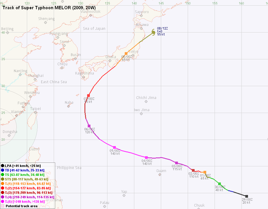
Table 1: Track data from HKWW:
表一 : 香港天氣觀測站之路徑資料
| YYMMDDZZ Lat Long Wind 09092900 094N1610E 020 09092906 102N1585E 025 09092912 105N1575E 035 09092918 109N1568E 040 09093000 117N1559E 040 09093006 126N1548E 045 09093012 129N1540E 055 09093018 130N1535E 060 09100100 139N1532E 065 09100106 139N1524E 090 09100112 141N1520E 095 09100118 140N1514E 110 09100200 142N1510E 110 09100206 145N1505E 120 09100212 150N1499E 120 09100218 154N1488E 115 09100300 156N1479E 115 09100306 162N1466E 115 09100312 166N1452E 120 09100318 165N1437E 130 09100400 166N1423E 140 09100406 170N1409E 140 09100412 175N1394E 140 09100418 179N1377E 140 09100500 185N1363E 140 09100506 192N1348E 140 09100512 200N1336E 135 09100518 212N1325E 130 09100600 225N1316E 120 09100606 239N1310E 110 09100612 251N1308E 105 09100618 266N1308E 100 09100700 282N1315E 095 09100706 299N1325E 090 09100712 318N1341E 085 09100718 337N1365E 075 09100800 360N1385E 065 09100806 380N1409E 060 09100812 400N1436E 055 |
Table 2: Track data from JTWC:
表二 : 聯合颱風警報中心之路徑資料
ID Name YYMMDD ZZZZ Lat Long Basin Wind Pres 20W MELOR 091008 0600 38.0N 141.0E WPAC 45 989 |
Last Accessed 最近訪問日期: Sun Sep 08 2024 12:43:19 HKT
Last Modified 最近修訂日期: Mon Jul 24 2023
