
TC Watch / 熱帶氣旋 > Selected TC Review / 重要熱帶氣旋回顧 > 200917W (KETSANA 凱薩娜) [Refresh 更新]
 200917W (KETSANA 凱薩娜) - Profile 檔案 200917W (KETSANA 凱薩娜) - Profile 檔案 |
(Issued on October 31, 2009)
(於 2009 年 10 月 31 日發出)
Brief profile of KETSANA 凱薩娜小檔案:
| JTWC number 聯合颱風警報中心 (JTWC) 號碼 | 17W |
| International number 國際編號 | 0916 |
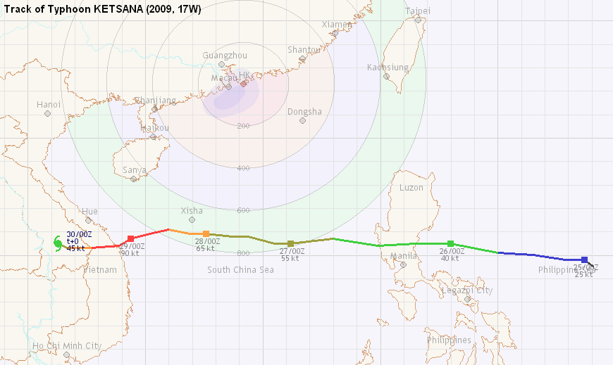
| Period of existence 生存時期 (JTWC) | 25 September, 2009 08 HKT to 29 September, 2009 20 HKT |
| Lifetime 壽命 (JTWC) | 4.50 days 日 |
| Maximum 1-minute wind (JTWC) JTWC 一分鐘平均最高中心風速 | 90 knots 節 (Category 2 Typhoon 二級颱風) |
| Minimum pressure (JTWC) JTWC 最低氣壓 | 955 hPa 百帕 |
| Highest TC signal by HKO (if applicable) 香港天文台發出最高熱帶氣旋警告信號 |
1 (Standby Signal 戒備信號) |
| Closest point of approach by HKO (if applicable) 香港天文台所示之最接近距離 (如適用) |
S 720 km (real-time warning 實時報告 and 及 TC report 熱帶氣旋報告) |
| Time of closest approach by HKO (if applicable) 香港天文台所示之最接近時間 (如適用) |
28 September, 2009 03 HKT (real-time warning) / 02 HKT (TC report) |
| Lowest pressure recorded at HKO (if applicable) 香港天文台錄得的最低氣壓 (如適用) |
1003.0 hPa 百帕 (28 September, 2009 04:33 to 04:45 HKT) |
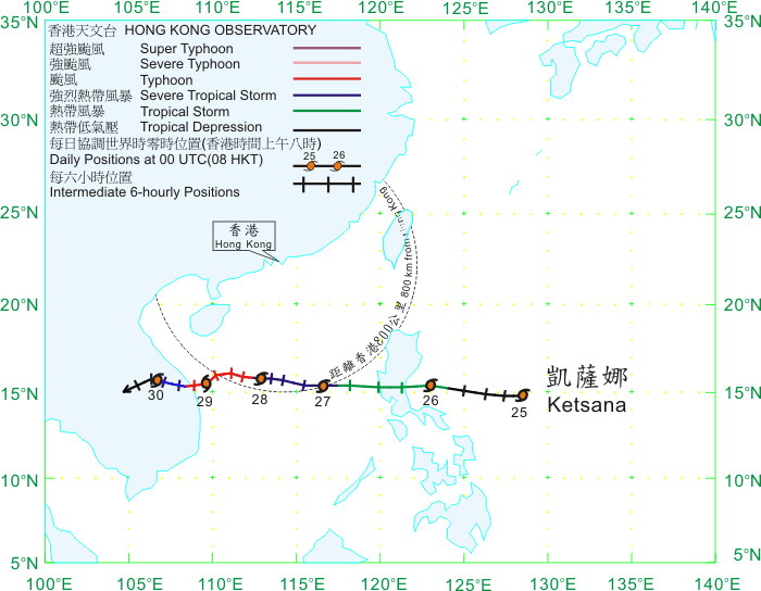
TC signals for Hong Kong & Track 香港曾經生效的熱帶氣旋警告和路徑圖:
Table 表:
| Signal 信號 |
Date and time 日期和時間 |
Distance from HK 與香港的距離 |
Predicted movement 預測移動方向和速度 |
Max. 10-min winds 中心最高十分鐘平均風速 |
 |
2009/09/27 (SUN) 22:15 HKT |
S 730 km |
W at 20 km/h |
90 km/h (50 knots, STS) |
 |
2009/09/28 (MON) 19:15 HKT |
SSW 760 km |
W at 14 km/h |
130 km/h (70 knots, CAT. 1 / TY^) |
^Storms having central wind speeds of above 117 km/h (63 knots) are classified using HKO's new TC classification system, with the addition of Severe Typhoon and Super Typhoon categories. 中心風力高於每小時 117 公里 (63 節) 的熱帶氣旋的分級依循香港天文台的新分級制度;該制度把颱風一級細分為颱風、強颱風和超強颱風。
Figure 圖:
(Track courtesy of Lorenzo. Data from HKO. 鳴謝 Lorenzo 提供路徑圖,資料取自天文台)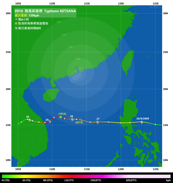
IR imagery animation 紅外線雲圖動畫:
TC track from HKWW 本站的熱帶氣旋路徑圖:
TC track from HKO 天文台的熱帶氣旋路徑圖:
| Past HKWW Bulletins on KETSANA 本站有關凱薩娜的發佈 |
Please click here for bulletins on KETSANA. 請按這裡。
| Storm Formation and Development 氣旋形成和發展 |
A tropical disturbance (96W) formed east of the Philippines, and gradually picked up strength in late September. The JTWC upgraded 96W into the seventeenth tropical depression of the year (17W) at 08 HKT on September 25, when it was some 600 km to the east of Manila. The HK Observatory upgraded it into tropical depression status just 2 hours afterwards.
Convections concentrated on 17W's western periphery at its formation, and it drifted westward quickly during the day. Since the subtropical ridge was firmly positioned in southern China, a general westward movement was predicted which turned out to be accurate.
Although convections were still confined to its western periphery a day later, its appearance improved with continuous burst of convections. The JMA designated 17W the 16th tropical storm of the year at 08 HKT on September 26, naming it KETSANA. "KETSANA" was contributed by Laos and it is the name of a rare type of trees found there.
KETSANA made landfall in eastern Luzon a few hours later, passing about 100 km north of Manila that afternoon. Although KETSANA was weak in terms of wind speed, it brought tremendous rainfall to the region, with Manila registering 341.3 mm of rainfall in just 6 hours, the highest since 1967. A state of calamity was declared on that day due to serious flooding, and the death toll in the country exceeded 400 as a result of the storm.
After causing serious damage to the Philippines, KETSANA entered South China Sea that night at a latitude of about 15.5°N. It remained fast until later on September 27 when it started to consolidate as steering influence diminished.
熱帶擾動 96W 於 9 月底在菲律賓以東海域形成,並逐漸增強。JTWC 於 25 日上午 8 時升格該擾動為熱帶低氣壓,編號為 17W,當時 17W 於馬尼拉以東 600 公里外;香港天文台亦於兩小時後將其升格為熱帶低氣壓。
於形成初時,17W 的對流集中在其西面,於當天快速向西移動。由於副熱帶高壓脊覆蓋華南,預測均一致指出 17W 將向西移至南海,與結果大致相符。
一天後,雖然對流仍然集中於系統西面,但其外觀轉好,對流持續爆發。日本氣象廳於 26 日上午 8 時升格 17W 為本年度第 16 個熱帶風暴,並命名為凱薩娜。凱薩娜一名由老撾提供,為當地一款樹木的名稱。
凱薩娜於數小時後在呂宋登陸,在當天下午於馬尼拉以北約 100 公里處掠過。雖然凱薩娜風速不高,但它為當地帶來傾盆大雨;馬尼拉於 6 小時內錄得 341.3 毫米的雨量,是自 1967 年以來最多。由於水浸情況嚴重,菲國多個省份於當天宣布進入災難狀態,最終死亡人數超過 400。
凱薩娜於橫掃菲律賓後於當晚進入南海,緯度為約 (北緯) 15.5 度。它的移速仍快,直至 27 日才因駛流減弱而逐步減慢。

Figure 1 - Steering chart at 14 HKT on September 26
圖 1 - 9 月 26 日下午 2 時的駛流圖
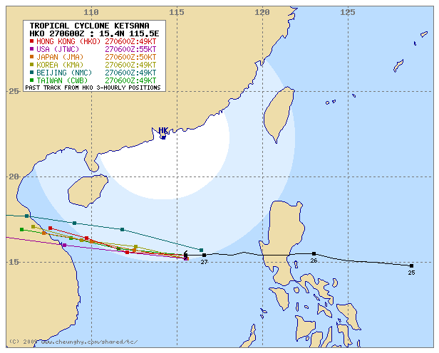
Figure 2 - Forecast by various agencies at 14 HKT on September 27
圖 2 - 各台於 9 月 27 日下午 2 時之預測路徑圖
| Signal Issuance 發出信號 |
With an improvement in its structure, KETSANA was upgraded to severe tropical storm status by the HKO at 08 HKT on September 27, when it was about 800 km from Hong Kong. Its wind radii were exceptionally wide, with 30-knot winds (56 km/h) extending to some 700 km from its centre as estimated by the JMA. Due to the combined effect of KETSANA and the background northeast monsoon, it was rather windy in South China coastal areas. Seas were also very rough, and an 18-year-old teenager was swept away by the waves while swimming in Sai Kung that day, whose body was retrieved a day later. As the HKO saw the influence of the storm outweighed that of the (at that time) weak northeast monsoon, the Observatory issued the #1 Standby Signal at 22:15 HKT, when KETSANA was 730 km south of Hong Kong. This indicated that strong winds may be observed in offshore waters and on high grounds.
KETSANA was closest to Hong Kong at about 02 HKT the next day, at a position only 10 km closer to Hong Kong than that when the Standby Signal was issued.
KETSANA intensified into a typhoon in the morning on September 28 when it developed a banding eye. Hong Kong was struck by the rain bands associated with KETSANA's outer circulation that day, which were formed when the moist southeasterly airstream met the drier northeast monsoon in which the warm, moist air was forced to move upward and produced precipitation (in some areas it is known as the Cuming effect). It remained overcast for the rest of the day. As KETSANA continued to move west it soon started moving away from the territory, and the Standby Signal was cancelled at 19:15 HKT on September 28.
凱薩娜的組織轉佳,於 27 日上午增強為強烈熱帶風暴,當時距離香港約 800 公里。它的風圈非常廣闊,30 節 (每小時 56 公里) 風圈半徑估計超越 700 公里。由於受到凱薩娜和背景東北季候風的共同影響,華南沿岸頗為大風,而海上亦有大浪。一名 18 歲的青年於西貢游泳時被大浪沖走,其遺體於一日後尋回。由於凱薩娜對本港造成一定影響,天文台於當晚 10 時 15 分發出一號戒備信號,表示離岸和高地可能吹強風。當時凱薩娜位於本港以南約 730 公里。
凱薩娜於 28 日上午 2 時最接近香港,但只是比發出一號信號時近 10 公里。
凱薩娜於當天上午增強為颱風,並開始發展出一雲捲風眼。香港受共伴效應 (在某些位置亦稱為奎明效應) 影響,濕潤的東南風與較冷的東北風相遇時被迫抬升並造成降雨,28 日整天天陰有雨。隨著凱薩娜西移,它開始移離本港,而戒備信號亦於當晚 7 時 15 分取消。

Figure 3 - JMA's forecast track at 11 HKT on September 28. Note the very wide 30-knot (56 km/h) wind radius.
圖 3 - 日本氣象廳於 9 月 28 日上午 11 時的預測路徑圖。留意 30 節 (每小時 56 公里) 風圈甚廣
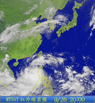


Figures 4a to 4c - KETSANA on satellite imageries from September 26 to 28.
圖 4a 至 4c - 9 月 26 至 28 日的衛星雲圖
| Landfall in Vietnam 於越南登陸 |
KETSANA further intensified into a category two typhoon at 20 HKT that night as per JTWC warning bulletins. It started to jog to the southwest near midnight, and made landfall in central Vietnam at about 15 HKT on September 29, still as a category two typhoon. Very strong winds were recorded in Vietnam with mean winds reaching 160 km/h; together with the flooding caused by the heavy rainfall KETSANA took away more than 180 lives in Vietnam.
In Hong Kong, the Strong Monsoon Signal was issued at 11:30 HKT on September 29 as strong winds were expected in the territory due to the combined effect of KETSANA and the northeast monsoon.
根據 JTWC 資料,凱薩娜於當晚進一步增強為二級颱風。它開始向西南移,於 29 日約下午 3 時在越南中部登陸,當時仍為二級颱風。當地錄得達每小時 160 公里的持續風速,亦受水浸影響,總計超過 180 人喪生。
香港方面,強烈季候風信號於 29 日上午 11 時 30 分發出。當時香港受季候風和凱薩娜影響,本地不少地區吹強風。

Figures 5 - KETSANA at maximum strength
圖 5 - 凱薩娜於顛峰強度時的衛星雲圖
KETSANA never moved out of land again, dissipating in eastern Thailand on September 30.
凱薩娜於越南登陸後逐漸減弱,於 9 月 30 日在泰國東部消散。
| Winds Recorded at Reference Stations 參考站所錄得的風速 |
(Except for special cases, this section is not available for cyclones that only necessitated the Standby Signal 除非特別情況,否則此部只當氣旋令天文台發出三號或更高信號時提供)
| Charts and Figures 各項數據 |
Table 1: Track data from HKWW:
表一 : 香港天氣觀測站之路徑資料
YYMMDDZZ Lat Long Wind |
Table 2: Maximum gust and 60-minute average wind speed recorded in Hong Kong from HKO:
表二 : 香港天文台公佈的各站最高 60 分鐘平均風力和陣風數據
Maximum Gust |
Maximum Hourly Wind |
|||||||
| Station | Direction |
Speed (km/h) |
Date/Month |
Time |
Direction |
Speed (km/h) |
Date/Month |
Time |
| Bluff Head (Stanley) | NE |
59 |
28/9 |
16:45 |
ENE |
30 |
27/9 |
23:00 |
| Central Pier | E |
43 |
28/9 |
08:55 |
E |
25 |
27/9 |
23:00 |
| Cheung Chau | NNE |
56 |
28/9 |
11:28 |
NNE |
31 |
28/9 |
12:00 |
| Cheung Chau Beach | NE |
52 |
28/9 |
10:09 |
NE |
40 |
28/9 |
07:00 |
| Cheung Sha Wan | NNE |
36 |
28/9 |
13:35 |
NE |
14 |
28/9 |
07:00 |
| Green Island | NNE |
58 |
28/9 |
09:15 |
NNE |
40 |
28/9 |
10:00 |
| Hong Kong International Airport | ENE |
51 |
28/9 |
17:26 |
NE |
30 |
28/9 |
07:00 |
| Kai Tak | E |
45 |
27/9 |
22:49 |
E |
20 |
27/9 |
23:00 |
| King's Park | NNE |
34 |
28/9 |
13:24 |
NE |
13 |
28/9 |
10:00 |
NE |
13 |
28/9 |
12:00 |
|||||
ENE |
13 |
28/9 |
19:00 |
|||||
| Lau Fau Shan | NE |
41 |
28/9 |
08:54 |
NE |
22 |
28/9 |
10:00 |
| Ngong Ping | ENE |
70 |
28/9 |
18:03 |
ENE |
52 |
28/9 |
12:00 |
| North Point | E |
40 |
28/9 |
00:00 |
E |
23 |
27/9 |
23:00 |
| Peng Chau | ENE |
36 |
28/9 |
06:59 |
E |
23 |
27/9 |
23:00 |
| Sai Kung | NE |
36 |
28/9 |
16:58 |
N |
20 |
28/9 |
05:00 |
N |
20 |
28/9 |
06:00 |
|||||
| Sha Chau | NNE |
54 |
28/9 |
17:24 |
NNE |
34 |
28/9 |
18:00 |
| Sha Lo Wan | ENE |
41 |
28/9 |
17:30 |
ENE |
20 |
28/9 |
06:00 |
| Sha Tin | NNE |
38 |
28/9 |
05:50 |
NNE |
16 |
28/9 |
06:00 |
| Shek Kong | ENE |
31 |
27/9 |
23:10 |
E |
16 |
27/9 |
23:00 |
ENE |
31 |
28/9 |
00:10 |
|||||
| Star Ferry (Kowloon) | SE |
36 |
28/9 |
07:39 |
SE |
22 |
27/9 |
23:00 |
| Ta Kwu Ling | NNE |
31 |
28/9 |
06:06 |
N |
12 |
28/9 |
06:00 |
| Tai Mei Tuk | NNE |
65 |
28/9 |
16:55 |
NE |
40 |
28/9 |
17:00 |
| Tai Mo Shan | NE |
75 |
28/9 |
16:39 |
ENE |
59 |
28/9 |
13:00 |
| Tap Mun | NE |
38 |
28/9 |
16:47 |
NE |
16 |
28/9 |
17:00 |
| Tate's Cairn | ENE |
87 |
28/9 |
17:34 |
ENE |
63 |
28/9 |
12:00 |
| Tsak Yue Wu | ENE |
31 |
28/9 |
16:51 |
NNE |
12 |
28/9 |
17:00 |
| Tseung Kwan O | N |
31 |
28/9 |
16:30 |
NNE |
13 |
28/9 |
17:00 |
| Tsing Yi Shell Oil Depot | S |
27 |
28/9 |
01:44 |
SE |
7 |
28/9 |
08:00 |
SE |
27 |
28/9 |
01:45 |
NW |
7 |
28/9 |
09:00 |
|
| Tuen Mun Government Offices | NNE |
47 |
28/9 |
15:58 |
NNE |
14 |
28/9 |
17:00 |
| Waglan Island | ENE |
68 |
28/9 |
01:19 |
ENE |
54 |
28/9 |
00:00 |
| Wetland Park | NE |
31 |
28/9 |
08:21 |
NE |
14 |
28/9 |
06:00 |
NE |
14 |
28/9 |
09:00 |
|||||
| Wong Chuk Hang | ESE |
51 |
28/9 |
01:25 |
E |
20 |
28/9 |
18:00 |
Table 3: Rainfall (in millimetres) contributed by KETSANA from HKO (figures in brackets are based on incomplete hourly data):
表三 : 香港天文台公佈的各站雨量資料 (方括號內之數據由不完整之每小時資料擷取)
| Station | 27 Sep |
28 Sep |
Total |
|
| Hong Kong Observatory | 0.0 |
52.7 |
52.7 |
|
| Cheung Chau (CCH) | 0.0 |
50.0 |
50.0 |
|
| Hong Kong International Airport (HKA) | 0.0 |
55.5 |
55.5 |
|
| N05 | Fanling | 0.0 |
30.0 |
30.0 |
| N13 | High Island | 0.0 |
77.5 |
77.5 |
| K04 | Jordan Valley | 0.0 |
67.5 |
67.5 |
| N06 | Kwai Chung | 0.0 |
55.5 |
55.5 |
| H12 | Mid Levels | 0.0 |
[69.0] |
[69.0] |
| H21 | Repulse Bay | 0.0 |
74.0 |
74.0 |
| N09 | Sha Tin | 0.0 |
49.5 |
49.5 |
| H19 | Shau Kei Wan | 0.0 |
65.0 |
65.0 |
| SEK | Shek Kong | 0.0 |
36.0 |
36.0 |
| K06 | So Uk Estate | 0.0 |
58.0 |
58.0 |
| R31 | Tai Mei Tuk | 0.0 |
39.5 |
39.5 |
| R21 | Tap Shek Kok | 0.0 |
42.0 |
42.0 |
| N17 | Tung Chung | 0.0 |
72.0 |
72.0 |
| R27 | Yuen Long | 0.0 |
[35.0] |
[35.0] |
Last Accessed 最近訪問日期: Sun Sep 08 2024 12:49:01 HKT
Last Modified 最近修訂日期: Mon Jul 24 2023
