
TC Watch / 熱帶氣旋 > Selected TC Review / 重要熱帶氣旋回顧 > 200916W (KOPPU 巨爵) [Refresh 更新]
 200916W (KOPPU 巨爵) - Profile 檔案 200916W (KOPPU 巨爵) - Profile 檔案 |
(First draft issued on September 24th, 2009; final version issued on October 10th, 2009)
(初稿於 2009 年 9 月 24 日發出,最後版本於 10 月 10 日上載)
Brief profile of KOPPU 巨爵小檔案:
| JTWC number 聯合颱風警報中心 (JTWC) 號碼 | 16W |
| International number 國際編號 | 0915 |
| Period of existence 生存時期 (JTWC) | 13 September, 2009 08 HKT to 15 September, 2009 08 HKT* |
| Lifetime 壽命 (JTWC) | 2.00 days 日* |
| Maximum 1-minute wind (JTWC) JTWC 一分鐘平均最高中心風速 | 75 knots 節 (Category 1 Typhoon 一級颱風) |
| Minimum pressure (JTWC) JTWC 最低氣壓 | 967 hPa 百帕 |
| Highest TC signal by HKO (if applicable) 香港天文台發出最高熱帶氣旋警告信號 |
8 (NE, SE) (Gale or Storm Signal 烈風或暴風信號) |
| Closest point of approach by HKO (if applicable) 香港天文台所示之最接近距離 (如適用) |
SW/WSW 140 km 公里 (real-time warning 實時報告: [1] [2]) / SSW 130 km 公里 (TC report 熱帶氣旋報告) |
| Time of closest approach by HKO (if applicable) 香港天文台所示之最接近時間 (如適用) |
15 September, 2009 03-04 HKT (real-time warning 實時報告) / 01 HKT (TC report 熱帶氣旋報告) |
| Lowest pressure recorded at HKO (if applicable) 香港天文台錄得的最低氣壓 (如適用) |
996.0 hPa 百帕 (15 September, 2009 00:42 - 01:16 HKT) |
*The JTWC issued final bulletin once KOPPU made landfall before its dissipation. 聯合颱風警報中心於巨爵登陸後不久發出最後警報,當時巨爵還未完全消散。
TC signals for Hong Kong & Track 香港曾經生效的熱帶氣旋警告和路徑圖:
Table 表:
| Signal 信號 |
Date and time 日期和時間 |
Distance from HK 與香港的距離 |
Predicted movement 預測移動方向和速度 |
Max. 10-min winds 中心最高十分鐘平均風速 |
 |
2009/09/13 (SUN) 20:35 HKT | SE 530 km | WNW at 20 km/h | 65 km/h (35 knots, TS) |
 |
2009/09/14 (MON) 11:15 HKT | SSE 280 km | W/WNW at 20 km/h | 105 km/h (57 knots, STS) |
 |
2009/09/14 (MON) 17:55 HKT | SSE 200 km | WNW at 16 km/h | 120 km/h (65 knots, CAT. 1 / TY^) |
 |
2009/09/15 (TUE) 00:35 HKT | SSW 150 km | WNW at 18 km/h | 130 km/h (70 knots, CAT. 1 / TY^) |
|
2009/09/15 (TUE) 10:15 HKT | W 260 km | WNW at 20 km/h | 120 km/h (65 knots, CAT. 1 / TY^) |
|
2009/09/15 (TUE) 13:35 HKT | W 330 km | WNW at 20 km/h | 100 km/h (54 knots, STS) |
 |
2009/09/15 (TUE) 15:40 HKT | W 370 km | WNW at 20 km/h | 85 km/h (45 knots, TS) |
^Storms having central wind speeds of above 117 km/h (63 knots) are classified using HKO's new TC classification system, with the addition of Severe Typhoon and Super Typhoon categories. 中心風力高於每小時 117 公里 (63 節) 的熱帶氣旋的分級依循香港天文台的新分級制度;該制度把颱風一級細分為颱風、強颱風和超強颱風。
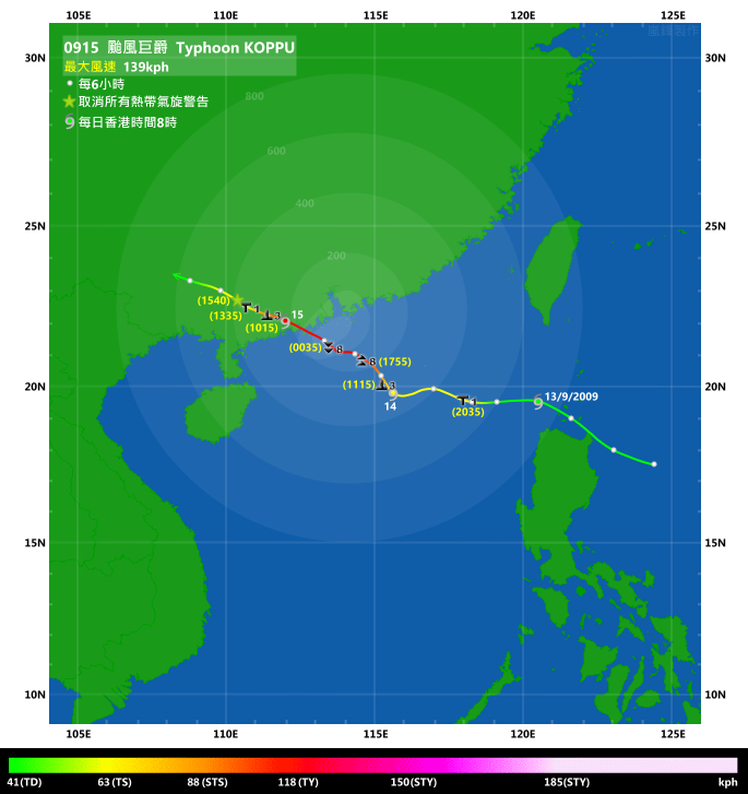
Figure 圖: (Track courtesy of Lorenzo. Data from HKO. 鳴謝 Lorenzo 提供路徑圖,資料取自天文台)
IR imagery animation 紅外線雲圖動畫:
TC track from HKWW 本站的熱帶氣旋路徑圖:
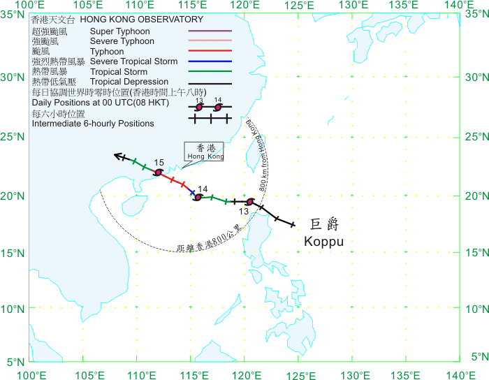
TC tracks from HKO 天文台的熱帶氣旋路徑圖:
| Past HKWW Bulletins on KOPPU 本站有關巨爵的發佈 |
Please click here for bulletins on KOPPU. 請按這裡。
| Storm Formation and Development 氣旋形成和發展 |
KOPPU is one of the few storms in recent years that managed to develop rapidly (within a day) from a minimal tropical storm to a typhoon in the South China Sea.
Just as Tropical Storm MUJIGAE made landfall in northern Vietnam, the disturbance east of the Philippines picked up strength and was upgraded to tropical depression status by the HKO at 16 HKT on September 12th. At that time, this depression was situated in the southwestern periphery of the subtropical ridge, and thus a general WNW movement was expected. The HKO also predicted a very close approach to Hong Kong in its very first track forecast.
巨爵是近年來少數能於一天內於南海由熱帶風暴增強至颱風級別的熱帶氣旋。
正當熱帶風暴彩虹於越南北部登陸,菲律賓以東的低壓區開始增強,並於 9 月 12 日下午 4 時被香港天文台升格為熱帶低氣壓。這時,該熱帶低氣壓正處於副熱帶高壓脊的西南方,因而預料會向西北偏西移動,進入南海。天文台於首報預測中已估計該氣旋可能於距離香港非常近的地方掠過。
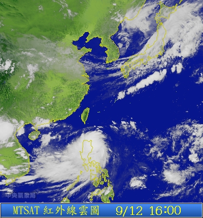
Figure 1 - Satellite imagery of the disturbance east of the Philippines when the HKO upgraded it into a tropical depression
圖 1 - 香港天文台升格菲律賓以東的低壓區為熱帶低氣壓時的衛星雲圖

Figure 2 - Initial forecast track from the HKO
圖 2 - 香港天文台初次發佈的路徑圖
As the system was in its initial development stage, its stability was low and it nearly made landfall at Luzon near midnight. It continued its fast movement and was just north of Luzon near dawn on September 13th. The low pressure has consolidated, and the JTWC started issuing warning bulletins at 08 HKT that day, giving it a storm number of 16W. Initial forecasts were not optimistic on its intensity, probably due to the current fast movement and that MUJIGAE failed to gain strength significantly when it was crossing the South China Sea a few days ago.
16W's subsidence brought generally fine weather over southeastern China, and Hong Kong experienced a hazy day with very hot weather. Most places recorded temperatures of above 33 degrees, while the mercury at Wong Tai Sin and Happy Valley registered 36.5 and 35.9 degrees respectively. Due to the intense heating of the ground convective activities were violent. Cumulonimbus clouds formed and crossed Hong Kong with intense thunderstorm activity between 18 and 20 HKT that night. More than 6000 cloud-to-ground strikes were recorded in the hour between 19 and 20 HKT and some weather stations (e.g. Ngong Ping and Cheung Chau) malfunctioned after being struck by lightning. The Amber Rainstorm Warning was issued at 19:15 HKT and remained in force for 1 hour and 15 minutes.
由於該熱帶低氣壓還是在發展初期,其位置穩定性較低,到午夜前後已接近登陸呂宋。它繼續其快速移動,並在 13 日近破曉時份到達呂宋以北海域。該熱帶低氣壓繼續整固,JTWC 於當天上午 8 時開始對其作出發佈,並給予編號 16W。初時各機構對於 16W 的強度預測均不樂觀,這可能是因為 16W 移動速度較快,而早幾天於南海快速移動的熱帶風暴彩虹也未能大幅增強的緣故。
16W 的下沉氣流於 13 日位華南沿岸帶來普遍晴朗的天氣,而香港當日天氣酷熱且有煙霞,大部分地區錄得超過 33 度的氣溫,而黃大仙及跑馬地更分別錄得 36.5 及 35.9 度。由於地面急速加熱,對流活動變得活躍,積雨雲形成並於當晚 6 至 8 時橫過香港,且伴有猛烈雷暴。本港於當晚 7 至 8 時共錄得超過 6000 雲對地閃電,而部分氣象站 (如昂坪和長洲) 因遭受雷擊而失靈。黃色暴雨警告信號於 13 日晚 7 時 15 分發出,1 小時 15 分鐘後取消。

Figure 3 - JTWC's initial forecast track
圖 3 - 聯合颱風警報中心初次發佈的路徑圖
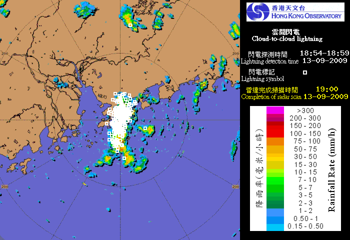
Figure 4 - RADAR image at 19 HKT on September 13th. White rectangles denote cloud-to-cloud lightning
圖 4 - 9 月 13 日下午 7 時之雷達圖。白點標示雲間閃電發生位置
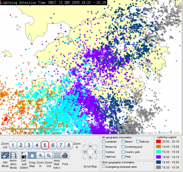
Figure 5 - Image showing cloud-to ground lightning strikes from 18:20 to 20:19 HKT on September 13th.
圖 5 - 9 月 13 日下午 6 時 20 分至 8 時 19 分之雲對地閃電位置圖

Figure 6 - Steering chart at 14 HKT on September 13th
圖 6 - 9 月 13 日下午 2 時之駛流圖
| KOPPU in Northern South China Sea 巨爵於南海北部時的情形 |
Shortly after the Amber Rainstorm Warning was cancelled, the focus was again back on 16W's movement and the HKO issued the #1 Standby Signal at 20:35 HKT, when it was 530 km southeast of Hong Kong. 16W was also upgraded to tropical storm status by the Observatory at that time.
16W continued to move west quickly for the rest of the night. Meanwhile, the JMA upgraded it into a tropical storm at 02 HKT on September 14th, naming it KOPPU. This name was contributed by Japan, meaning the constellation Crater (Cup). At this time the HKO was already giving the system a strength of 85 km/h (45 knots), the upper limit of a tropical storm. As daylight came, visible imageries were once again available and it was evident that KOPPU was forming a banding eye, implying that its strength might have been underestimated.
The HKO mentioned in the 10 HKT bulletin that, as winds in the territory were picking up, the Strong Wind Signal would be issued in the next couple of hours. It was also the time that KOPPU decelerated and started a more northerly track.
The #3 Strong Wind Signal was issued at 11:15 HKT, together with the upgrade of KOPPU into a severe tropical storm possibly because of the (clearly) discernible eye. Strong winds were blowing in offshore waters and on high grounds at the time the signal was issued, and winds in the territory were expected to strengthen further.
黃色暴雨警告信號取消後不久,焦點再次回到 16W 的身上。天文台於晚上 8 時 35 分發出一號戒備信號,當時該氣旋集結於香港東南約 530 公里。同時,天文台把 16W 升格為熱帶風暴。
16W 於當晚繼續快速向西移動。日本氣象廳於 14 日凌晨 2 時升格 16W 至熱帶風暴級別,並把其命名為巨爵。巨爵一名由日本提供,為一星座的名稱。天文台於此時已估計巨爵中心風力達每小時 85 公里 (45 節),為熱帶風暴強度上限。隨著日光到來,可見光雲圖顯示巨爵正建立雲捲風眼,暗示它的強度可能被低估。
天文台於上午 10 時的發佈中指出,由於本地風勢漸趨強勁,三號信號將於未來數小時內發出。巨爵於差不多同一時間減速並開始採取一個較北的路徑。
天文台其後於上午 11 時 15 分發出三號強風信號,並升格巨爵為強烈熱帶風暴 (可能由於風眼可見的關係)。離岸和高地當時吹強風,而本地普遍風力預料會繼續增強。

Figure 7 - Image of KOPPU, September 14th 11:30 HKT
圖 7 - 巨爵於 9 月 14 日上午 11 時 30 分的影像
The persistent northwesterly track that KOPPU took greatly increased its threat to Hong Kong, and therefore the Observatory mentioned that they would consider the need of higher signals around sunset. Various news of temporary suspension of ferry services to outlying islands was disseminated in the afternoon, and handling of empty and laden cargo was scheduled to be suspended at 17 HKT and 18 HKT respectively.
That afternoon official agencies gradually adjusted KOPPU's strength upwards, with the HKO, CMA, and JTWC giving it a strength of about 100-110 km/h (54 to 60 knots, the latter being the upper limit of a severe tropical storm) and JMA giving it 90 km/h (50 knots).
巨爵於其後數小時繼續其西北路徑,對香港的威脅大幅增加,因而天文台表示會於日落前後考慮改發更高信號。有關小輪服務暫停的消息於午後陸續發放,而吉櫃和重櫃交收亦將於當天下午 5 及 6 時暫停。
各大機構紛紛於 14 日下午逐步提升巨爵的強度,香港天文台、中國氣象局和聯合颱風警報中心所給予的強度為每小時 100 至 110 公里之間 (54 至 60 節,後者為強烈熱帶風暴強度上限),而日本氣象廳所給出的強度則為每小時 90 公里 (50 節)。
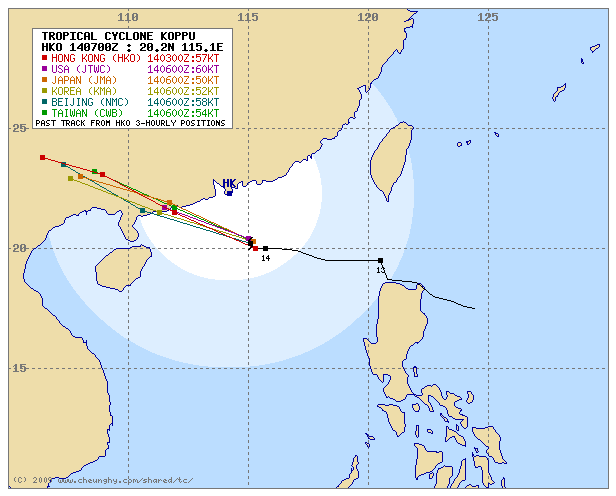
Figure 8 - Forecast tracks from various agencies, September 14th 14 HKT
圖 8 - 各官方氣象台於 9 月 14 日下午 2 時之預測路徑圖

Figure 9 - HKO's forecast track. Forecast track data issued for 17 HKT while current position was recorded at 20 HKT (September 14th)
圖 9 - 香港天文台的路徑圖。預測路徑為 9 月 14 日下午 5 時發出,而實時位置則為下午 8 時的資料
| Signal 8 in Hong Kong 香港於八號信號生效期間的情況 |
KOPPU showed no sign of turning west throughout the afternoon, and if such track was to be continued KOPPU could enter the 100-km circle. As winds continued to strengthen, the HKO adopted a similar strategy as that used in the approach of Typhoon HAGUPIT last year by disseminating the Pre-No. 8 Special Announcement at 16 HKT, stating that the #8 Signal would be issued by 18 HKT the latest. Due to the possible superimposition with high tide the next morning, the Observatory specifically reminded people living in low-lying areas to take all necessary precautions to minimize loss due to storm surge. At about 16 HKT, sustained gale force winds were already recorded at Waglan Island, Tate's Cairn and Green Island, while sustained strong force winds were observed at Cheung Chau, Sai Kung, Tai Mei Tuk, Sha Chau and Chek Lap Kok. As the wind vane and anemometer at Cheung Chau (main station) were damaged in the severe thunderstorms the day before (September 13th), the Observatory made the data at Cheung Chau Beach (at a lower altitude) available. It would later indicate that the station was very sensitive to northeasterly winds while somewhat obscured to the southeast.
The Observatory kept its promise by issuing the #8 Northeast Gale or Storm Signal at 17:55 HKT, and at the same time upgraded KOPPU into a typhoon. KOPPU was about 200 km SSE of Hong Kong at that moment, and from RADAR a ragged eye could be seen (at a position closer than that announced by the Observatory). Due to the deteriorating weather, ferry services to Macau were suspended at 18 HKT, and that of Star Ferry were suspended one hour later.
Locally the onset of storm force winds in offshore waters occurred at about the same time as the issuance of #8 Signal. Places unobstructed to the northeast like Cheung Chau, Sai Kung and Waglan Island generally saw a surge in wind speed after sunset. KOPPU continued to strengthen, with the eye becoming much rounder later that night. It has also turned to a more westerly track, implying that the chance of higher signals can almost be completely ruled out.
Winds in most places were the strongest from 22 HKT on September 14th to 00 HKT on September 15th. Sustained hurricane force winds of 124 km/h (67 knots) were recorded at Tate's Cairn. Waglan came close to having hurricane force winds by recording a wind speed of 116 km/h (63 km/h) at about 21:40 HKT. Other places that registered sustained winds of at least 100 km/h (54 knots) include Cheung Chau (both the main station and Cheung Chau Beach), Green Island and Tai Mei Tuk. Gusts in many places reached 100 km/h, with Tate's Cairn and Green Island recording 158 km/h (85 knots) and 152 km/h (82 knots) respectively. Winds over the night were very strong and were comparable to those recorded during HAGUPIT's visit last year (although somewhat weaker).
As KOPPU moved west-northwest, it came to Hong Kong's southwest quadrant after midnight. To warn the public about the impending veering of the wind direction, the Observatory issued the #8 Southeast Gale or Storm Signal at 00:35 HKT on September 15th, replacing the Northeast one. KOPPU was about 150 km SSW of the Observatory at that time.
巨爵整天下午沒有轉回向西的趨勢,而如果其西北路徑得以繼續的話巨爵將有可能進入本港 100 公里範圍。由於本地風勢持續增強,天文台採取跟去年颱風黑格比襲港時相類似的策略,於下午 4 時發出預警八號熱帶氣旋警告信號之特別報告,說明八號信號將於兩小時內發出。由於預測第二天 (15 日) 早上為漲潮時間,天文台特別提醒居於低窪地區的市民採取所有預防措施,以減少因風暴潮而造成的損失。於下午 4 時左右,橫瀾島、大老山和青洲均已錄得持續烈風風速,而長洲、西貢、大美督、沙洲和赤鱲角就錄得持續強風。由於長洲主站的風速計和風向儀於 13 日晚的閃電中被破壞,天文台改而發放於較低高度的長洲泳灘站的資料。於當天稍後的數據顯示,該站對於東北風非常敏感,而東南面則可能被屏蔽。
天文台履行承諾,於下午 5 時 55 分發出八號東北烈風或暴風信號,並同時升格巨爵為颱風。當時巨爵位於本港東南偏南約 200 公里處,而從雷達圖可見一粗糙的風眼 (於天文台公佈距離以內)。由於市面情況逐漸變得惡劣,往澳門的輪船服務於下午 6 時暫停,而天星小輪亦於一小時後暫停運作。
本港風勢方面,八號信號發出前後,離岸地區已開始吹暴風。東北面比較少屏障的站點如長洲、西貢和橫瀾島的風速普遍於日落後急速上升。巨爵繼續增強,其風眼於當晚較後時間變得渾圓。它亦於晚間開始偏西的路徑,發出較高信號的機會幾乎可以完全排除。
大多數地區風勢於 14 晚 10 時至 15 日凌晨 12 時最為猛烈。大老山曾錄得颶風,持續風速達每小時 124 公里 (67 節)。橫瀾島亦幾乎錄到颶風,其最高持續風速為於晚上 9 時 40 分左右錄得的每小時 116 公里 (63 節)。其餘錄到每小時風速達 100 公里 (54 節) 的地區有長洲 (包括主站和泳灘)、青洲和大美督。很多地區亦錄到高逾每小時 100 公里的陣風,例如大老山和青則分別錄得陣風達每小時 158 及 152 公里 (85 和 82 節)。風力整晚維持強勁,只較去年黑格比來襲時錄得的低少許。
隨著巨爵向西北偏西移動,它於午夜過後到達香港的西南象限。天文台於 9 月 15 日凌晨 12 時 35 分改發八號東南烈風或暴風信號,取代東北信號,來提醒市民風向即將改變。改發信號時巨爵於香港天文台西南偏南大約 150 公里處。


Figures 10a to 10d - Wind speeds during the passage of KOPPU at Cheung Chau, Kai Tak, Tate's Cairn and Waglan Island respectively
圖 10a 至 10d - 巨爵襲港時於長洲、啟德、大老山和橫欄島錄得的風速


Figures 11a to 11c - Mean sea level pressure during the passage of KOPPU at Chek Lap Kok, Hong Kong Observatory and Waglan Island respectively
圖 11a 至 11c - 巨爵襲港時於赤鱲角、天文台和橫欄島錄得的氣壓讀數
Meanwhile, KOPPU continued to intensify with its eye becoming more developed in RADAR images. In its tropical cyclone warning for shipping report for 02 HKT, KOPPU was packing winds of 140 km/h (75 knots) near its centre. According to HKO's tropical cyclone bulletins, KOPPU was closest to Hong Kong at around 03 HKT when it was 140 km SW of the Observatory. However, the peak wind speeds in most places were recorded a few hours ago, and was on a declining trend at that time. The strong winds caused some automatic weather stations to malfunction, and in one report the HKO mentioned that Stanley was blowing winds of 250 km/h (135 knots), which was of course an error.
Heavy rain affected the territory overnight, with more than 30 mm of rain recorded in most places from the hour between 02:45 to 03:45 HKT. The Observatory issued the Amber Rainstorm Warning and Special Announcement on Flooding in the Northern New Territories at 03:55 HKT. The latter remained in force until 10:15 HKT while the former 10:20 HKT.
The first high tide on September 15th was predicted to occur at about 05:30 HKT, and as KOPPU was a strong tropical cyclone passing quite close of the territory, the Observatory warned beforehand that low-lying areas, especially Tai O and places that suffered from damage during the passage of HAGUPIT last year, might be under severe threat of flooding. This was also the first time that the flood alert system set up for Tai O residents was activated; people there were warned in advance via SMS text messages about possible flood damage. The HKO mentioned in the tropical cyclone bulletin that the storm surge had led to water levels of about 1 metre above normal.
與此同時,巨爵繼續增強,從雷達圖看來它的風眼漸趨完整。天文台於凌晨 2 時的船舶熱帶氣旋警告指出巨爵的中心風力達每小時 140 公里 (75 節)。根據天文台的實時熱帶氣旋警報,巨爵於上午 3 時左右最接近香港,當時位於天文台西南約 140 公里。但是,最強勁的風速經已過去,凌晨過後各區風力逐漸減弱。徹夜狂風令部份氣象站失靈,而天文台曾錯誤地於其中一篇有關本港風速的新聞稿中指出赤柱錄得每小時 250 公里 (135 節) 的持續風速。
大雨亦於凌晨過後影響香港,大部分地區於上午 2 時 45 分至 3 時 45 分錄得超過 30 毫米的雨量。天文台於上午 3 時 55 分同時發出黃色暴雨警告信號和新界北部水浸特別報告。後者於上午 10 時 15 分解除,而前者則維持至上午 10 時 20 分。
15 日的首次潮漲於約上午 5 時 30 分出現。由於巨爵為一偏強的熱帶氣旋且與香港距離不遠,天文台提早發出警告,指出大澳等於颱風黑格比來襲時受到水浸影響的低窪地區可能受到風暴潮和漲潮影響而再度出現水浸。這也是為大澳居民而設的水浸警報系統之首次正式運作,當地居民透過手機短信預先收到有關可能出現水浸的消息。天文台於熱帶氣旋警報中指出風暴潮令潮水比正常高約 1 米。


Figures 12a to 12f - KOPPU as seen on RADAR. Images were taken at 12, 16 and 20 HKT of September 14th, and 00, 04 and 08 HKT of September 15th.
圖 12a 至 12f - 9 月 14 日 12、16 和 20 時,以及 15 日 0、4 和 8 時之雷達圖。


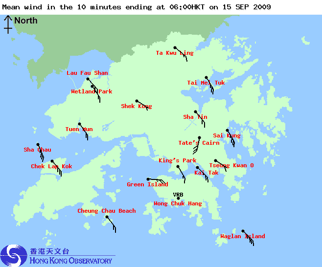
Figures 13a to 13f - Wind directions and speeds across Hong Kong at 15, 18 and 21 HKT of September 14th, and 00, 03 and 06 HKT of September 15th.
圖 13a 至 13f - 9 月 14 日 15、18 和 21 時,以及 15 日 0、3 和 6 時之風向和風速分布圖


Figures 14a and 14b - Malfunction of the wind measurement facilities at Cheung Chau and Stanley automatic weather stations. The former was struck by lightning on September 13th while the latter is believed to be damaged by the strong wind.
圖 14a 和 14b - 長洲和赤柱風速計和風向儀分別於 9 月 13 日和 15 日失靈

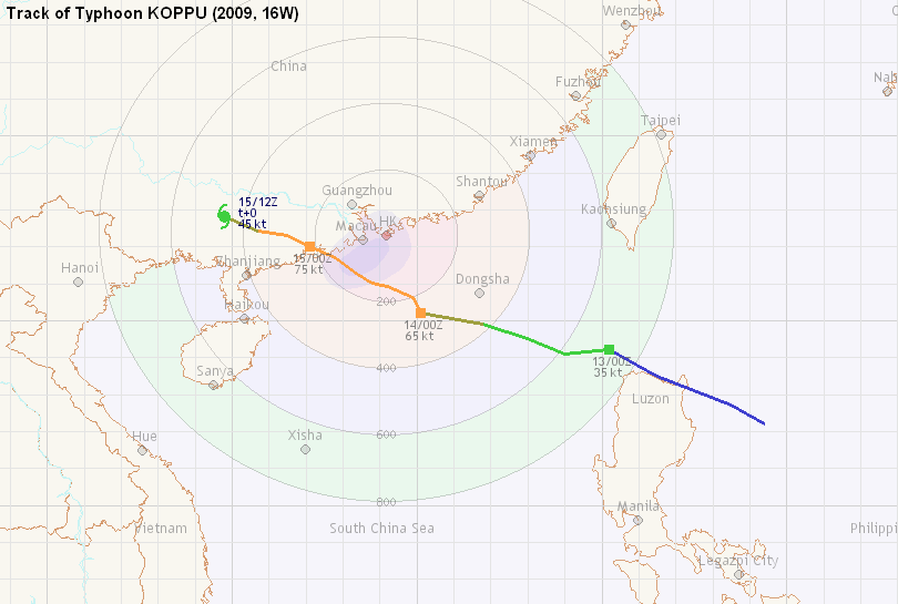
Figure 15 - Track and intensity of KOPPU in the South China Sea
圖 15 - 巨爵於南海的路徑和強度

Figure 16 - Image of KOPPU, September 15th 00:30 HKT
圖 16 - 巨爵於 9 月 15 日凌晨 12 時 30 分的影像
| Landfall and Subsequent Weakening 登陸並減弱 |
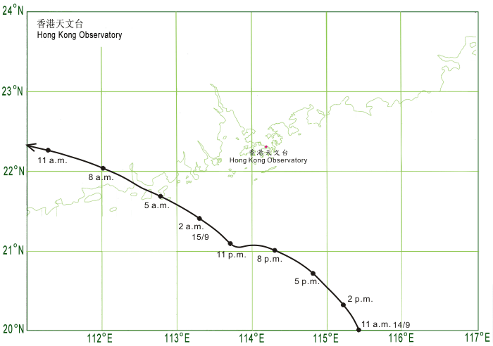
Still travelling in a (general) WNW direction, KOPPU's eye swept past Shangchuan Dao at about 05 HKT on September 15th. The Observatory mentioned in their 06 HKT bulletin that the #3 Signal would be considered at about 10 HKT. This statement allowed citizens to plan their journey back to work well ahead of the time that the #8 Signal was replaced, but still most would have to wait until public transport resumed normal service after the signal replacement.
According to the China Meteorological Administration, KOPPU made landfall near Taishan at 07 HKT, becoming the second strongest tropical cyclone this year to make landfall in China (the strongest being Typhoon MOLAVE in July). The Hong Kong Observatory issued the #3 Strong Wind Signal at 10:15 HKT, when winds in urban areas weakened to strong force while occasional gales were confined to offshore places and on high ground. The city then had a busy time carrying large number of commuters back to work.
The HKO downgraded KOPPU into a severe tropical storm at 11 HKT, and the #3 Signal was replaced by the #1 Standby Signal at 13:35 HKT when winds subsided further. All signals were cancelled at 15:40 HKT when the Observatory downgraded KOPPU into a tropical storm.
Affected by a rain band associated with KOPPU, torrential rain fell near dusk on September 15th, and the Observatory issued the Amber Rainstorm Warning for a second time of the day at 17:55 HKT. The Landslip Warning was issued shortly after (at 18 HKT), as most places in Hong Kong generally recorded more than 150 mm of rain in 24 hours' time, which may increase the risk of landslide. The Amber Rainstorm Warning remained in force for about 2 hours, and was cancelled at 19:45 HKT. The Landslip Warning, on the other hand, was cancelled at 00:30 HKT the next day.
KOPPU was downgraded into a tropical depression at 02 HKT on September 16th, and dissipated in Guangxi soon afterwards.
巨爵於 15 日上午 5 時左右橫過上川島,當時它仍然向西北偏西移動。天文台於上午 6 時提及將於上午 10 時考慮改發三號信號,這令市民能於八號信號取消前提早準備上班,但由於大部分交通工具仍然暫停運作,很多人仍要待信號替換後才能返回工作地點。
根據中國氣象局,巨爵於上午 7 時在台山登陸,為本年登陸中國第二強的熱帶氣旋 (最強為 7 月的颱風莫拉菲)。香港天文台於上午 10 時 15 分改發三號強風信號,當時市區吹強風,而離岸和高地則間中吹烈風。市民紛紛趕上班,多處交通非常繁忙。
天文台於上午 11 時把巨爵降格為強烈熱帶風暴,繼而於下午 1 時 35 分改發一號戒備信號。所有熱帶氣旋警告信號於下午 3 時 40 分取消,而天文台同時降格巨爵為熱帶風暴。
受到巨爵外圍雨帶影響,15 日傍晚本港落下傾盆大雨,天文台因此在下午 5 時 55 分發出當天第二個黃色暴雨警告信號。由於本港多處於 24 小時內落下超過 150 毫米的大雨,天文台於 5 分鐘後發出山泥傾瀉警告,提醒市民遠離不穩定的山坡。黃色暴雨警告信號維持了約兩小時,於下午 7 時 45 分解除;而山泥傾瀉警告則維持至翌日凌晨 12 時 30 分。
巨爵於 9 月 16 日上午 2 時減弱為熱帶低氣壓,其後於廣西內陸消散。

Figure 17 - This rain band necessitated the second Amber Rainstorm Warning of September 15th
圖 17 - 這條雨帶令天文台發出 9 月 15 日裡的第二個黃色暴雨警告信號
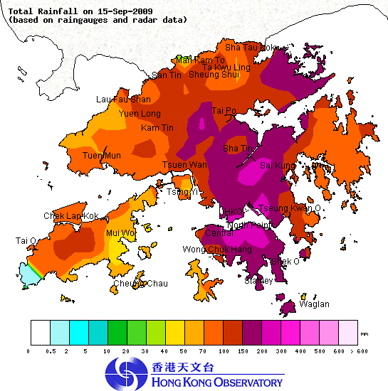
Figure 18 - Isohyet chart for September 15th
圖 18 - 9 月 15 日的等雨量線圖
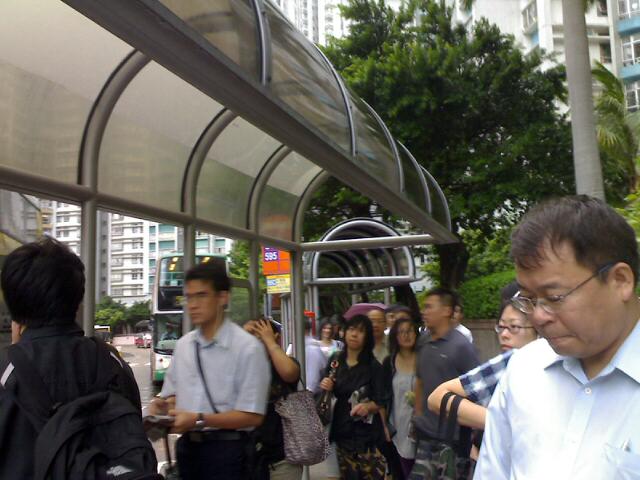
Figure 19 - People rushing to work at about 10 HKT on September 15th. Photo taken from RTHK.
圖 19 - 市民於 9 月 15 日約上午 10 時紛紛趕上班。圖片由香港電台提供
| Damage to Hong Kong brought by KOPPU 巨爵對香港造成的破壞 |
During the passage of KOPPU, 74 people were injured and 340 cases of fallen trees were reported. Due to the heavy rainfall and storm surge, there were also 8 flooding reports. With the flood alert system in place, damage to Tai O was reduced. It was fortunate that all those affected only suffered minor injuries.
巨爵襲港共造成 74 人受傷,而政府亦分別接獲 340 及 6 宗塌樹和水浸報告,另水浸警報系統成功為大澳減少破壞。值得慶幸的是全部受傷人士皆只受輕傷,而沒有嚴重傷亡報告。
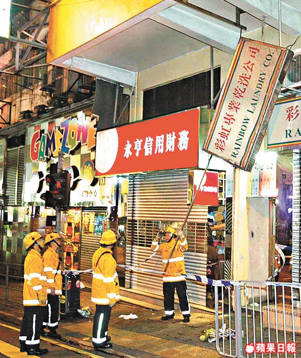
Figure 20 - Firefighters removing dangling scaffolding. Image taken from Apple Daily.
圖 20 - 消防員將搖搖欲墜的招牌拆走。圖片由蘋果日報提供
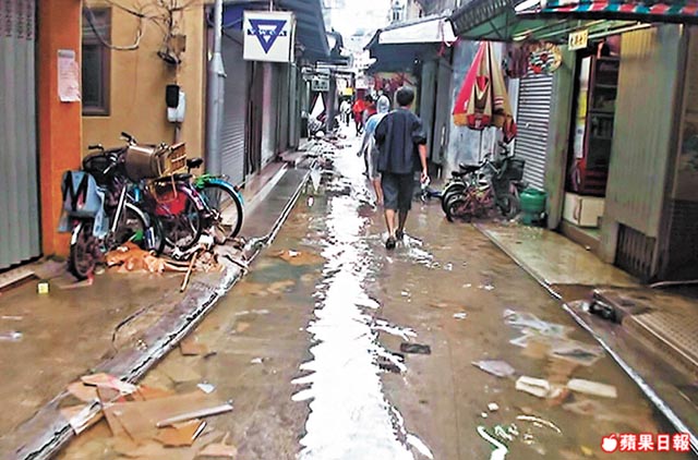
Figure 21 - Water receding from the flood-prone streets in Tai O. Image taken from Apple Daily.
圖 21 - 颱風過後大澳路面積水退卻。圖片由蘋果日報提供
| Winds Recorded at Reference Stations 參考站所錄得的風速 |
| Station 風速站 |
Max. 10-min avg. wind speed 最高十分鐘平均風速 |
Beaufort classification 蒲福氏風級分類 |
| Chek Lap Kok 赤鱲角 | 86 km/h | GALE 烈風 |
| Cheung Chau 長洲 | 112 km/h | STORM 暴風 |
| Kai Tak 啟德 | 76 km/h | GALE 烈風 |
| Sai Kung 西貢 | 79 km/h | GALE 烈風 |
| Sha Tin 沙田 | 40 km/h | Fresh 清勁 |
| Ta Kwu Ling 打鼓嶺 | 45 km/h | STRONG 強風 |
| Tsing Yi (SHL) 青衣蜆殼油庫 | No Data 沒有資料 | --- |
| Wetland Park 濕地公園 | 43 km/h | STRONG 強風 |
| Number of stations recording at least STRONG force (force 6 - 7) winds: | 6 |
Number of stations recording at least GALE force (force 8 - 9) winds: |
4 |
| Number of stations recording at least STORM force (force 10 - 11) winds: | 1 |
| Number of stations recording HURRICANE force (force 12) winds: | 0 |
| 錄得 強風 (6 - 7 級) 或更高風速的站數: | 6 |
| 錄得 烈風 (8 - 9 級) 或更高風速的站數: | 4 |
| 錄得 暴風 (10 - 11 級) 或更高風速的站數: | 1 |
| 錄得 颶風 (12 級) 風速的站數: | 0 |
| Charts and Figures 各項數據 |
Table 1: Track data from HKWW:
表一 : 香港天氣觀測站之路徑資料
| YYMMDDZZ Lat Long Wind 09091206 172N1244E 025 09091212 177N1235E 030 09091218 185N1215E 030 09091300 192N1202E 035 09091306 191N1190E 040 09091312 195N1180E 040 09091318 199N1168E 050 09091400 202N1151E 065 09091406 206N1149E 065 09091412 209N1142E 070 09091415 210N1138E 075 09091418 213N1133E 075 09091421 217N1128E 075 09091500 220N1121E 075 09091503 223N1115E 065 09091506 224N1107E 050 09091512 228N1098E 045 |
Table 2: Maximum gust and 60-minute average wind speed recorded in Hong Kong from HKO:
表二 : 香港天文台公佈的各站最高 60 分鐘平均風力和陣風數據
Maximum Gust |
Maximum Hourly Wind |
|||||||
| Station | Direction |
Speed (km/h) |
Date/Month |
Time |
Direction |
Speed (km/h) |
Date/Month |
Time |
| Bluff Head (Stanley) | ENE |
131 |
14/9 |
20:58 |
ESE |
77 |
15/9 |
02:00 |
| Central Pier | E |
118 |
14/9 |
23:40 |
E |
70 |
14/9 |
23:00 |
| Cheung Chau* | - |
142 |
15/9 |
00:06 |
- |
106 |
15/9 |
02:00 |
| Cheung Chau Beach | E |
151 |
14/9 |
22:56 |
E |
104 |
14/9 |
23:00 |
| Cheung Sha Wan | NE |
90 |
14/9 |
21:25 |
NE |
34 |
14/9 |
22:00 |
| Green Island | NE |
151 |
14/9 |
21:37 |
NE |
99 |
14/9 |
22:00 |
NE |
151 |
14/9 |
23:08 |
|||||
| Hong Kong International Airport | SE |
115 |
15/9 |
04:36 |
ESE |
68 |
15/9 |
03:00 |
| Kai Tak | E |
115 |
15/9 |
02:28 |
E |
63 |
15/9 |
02:00 |
| King's Park | E |
118 |
14/9 |
22:44 |
ESE |
47 |
15/9 |
01:00 |
| Lau Fau Shan | E |
96 |
15/9 |
00:50 |
E |
51 |
15/9 |
00:00 |
| North Point | E |
118 |
14/9 |
21:50 |
E |
65 |
15/9 |
00:00 |
| Ping Chau | E |
104 |
14/9 |
22:33 |
E |
40 |
14/9 |
23:00 |
| Sai Kung | ENE |
122 |
14/9 |
21:49 |
ENE |
72 |
14/9 |
23:00 |
| Sha Chau | SE |
117 |
15/9 |
03:47 |
SE |
75 |
15/9 |
04:00 |
| Sha Lo Wan | E |
140 |
15/9 |
03:30 |
E |
62 |
14/9 |
23:00 |
| Sha Tin | ENE |
87 |
14/9 |
22:18 |
SE |
31 |
15/9 |
05:00 |
| Shek Kong | NE |
121 |
14/9 |
22:42 |
E |
47 |
15/9 |
01:00 |
| Star Ferry (Kowloon) | ESE |
110 |
14/9 |
23:22 |
E |
59 |
15/9 |
00:00 |
| Ta Kwu Ling | E |
88 |
15/9 |
01:22 |
E |
38 |
15/9 |
04:00 |
| Tai Mei Tuk | E |
131 |
14/9 |
23:33 |
E |
88 |
15/9 |
00:00 |
E |
88 |
15/9 |
01:00 |
|||||
| Tate's Cairn | ESE |
158 |
14/9 |
23:21 |
E |
101 |
14/9 |
22:00 |
| Tsak Yue Wu | ENE |
70 |
14/9 |
22:21 |
E |
25 |
14/9 |
23:00 |
| Tseung Kwan O | NNE |
92 |
14/9 |
20:25 |
NNE |
31 |
14/9 |
20:00 |
| Tsing Yi Shell Oil Depot | E |
88 |
15/9 |
00:44 |
ESE |
43 |
15/9 |
05:00 |
| Tuen Mun Government Offices | SE |
110 |
15/9 |
03:58 |
SE |
40 |
15/9 |
04:00 |
| Waglan Island | ENE |
139 |
14/9 |
21:33 |
E |
112 |
14/9 |
22:00 |
| Wetland Park | E |
83 |
15/9 |
00:59 |
E |
38 |
15/9 |
00:00 |
| Wong Chuk Hang | SE |
130 |
15/9 |
00:01 |
E |
49 |
14/9 |
23:00 |
* As the wind direction sensor at Cheung Chau Automatic Weather Station was damaged by thunderstorms, please refer to the wind direction recorded at Cheung Chau Beach. 由於長洲自動氣象站的風向儀受到雷暴影響失靈,請參考長洲泳灘的風向紀錄。
Table 3: Rainfall contributed by KOPPU from HKO (figures in brackets are based on incomplete hourly data):
表三 : 香港天文台公佈的各站雨量資料 (方括號內之數據由不完整之每小時資料擷取)
| Station | 13 Sep |
14 Sep |
15 Sep |
Total |
|
Hong Kong Observatory |
23.4 |
38.8 |
190.3 |
252.5 |
|
Cheung Chau (N26) |
38.0 |
33.5 |
59.5 |
131.0 |
|
Hong Kong International Airport (HKA) |
0.6 |
28.6 |
89.6 |
118.8 |
|
N13 |
High Island | 11.0 |
27.5 |
72.0 |
110.5 |
K04 |
Jordan Valley | 18.5 |
48.0 |
200.0 |
266.5 |
N06 |
Kwai Chung | 42.0 |
45.0 |
154.5 |
241.5 |
H12 |
Mid Levels | 24.5 |
46.5 |
122.5 |
193.5 |
H21 |
Repulse bay | 39.0 |
41.5 |
169.0 |
249.5 |
N09 |
Sha Tin | 14.0 |
46.0 |
177.5 |
237.5 |
H19 |
Shau Kei Wan | 27.5 |
33.0 |
123.0 |
183.5 |
SEK |
Shek Kong | 4.5 |
43.5 |
148.0 |
196.0 |
K06 |
So Uk Estate | 45.0 |
53.5 |
173.5 |
272.0 |
R31 |
Tai Mei Tuk | 25.5 |
1.0 |
143.5 |
170.0 |
R21 |
Tap Shek Kok | 1.0 |
32.5 |
74.5 |
108.0 |
N17 |
Tung Chung | 4.5 |
53.0 |
100.0 |
157.5 |
R27 |
Yuen Long | 5.0 |
45.5 |
87.0 |
137.5 |
Last Accessed 最近訪問日期: Sun Sep 08 2024 12:47:50 HKT
Last Modified 最近修訂日期: Mon Jul 24 2023
