
TC Watch / 熱帶氣旋 > Selected TC Review / 重要熱帶氣旋回顧 > 200914W (MUJIGAE 彩虹) [Refresh 更新]
 200914W (MUJIGAE 彩虹) - Profile 檔案 200914W (MUJIGAE 彩虹) - Profile 檔案 |
(First draft issued on September 17th, 2009; final version issued on October 4th, 2009)
(初稿於 2009 年 9 月 17 日發出,最後版本於 10 月 4 日上載)
Brief profile of MUJIGAE 彩虹小檔案:
| JTWC number 聯合颱風警報中心 (JTWC) 號碼 | 14W |
| International number 國際編號 | 0913 |
| Period of existence 生存時期 | 9 September, 2009 14 HKT to 12 September, 2009 08 HKT |
| Lifetime 壽命 | 2.75 days 日 |
| Maximum 1-minute wind (JTWC) JTWC 一分鐘平均最高中心風速 | 30 knots 節 (Tropical Depression 熱帶低氣壓) |
| Minimum pressure (JTWC) JTWC 最低氣壓 | 998 hPa 百帕 |
| Highest TC signal by HKO (if applicable) 香港天文台發出最高熱帶氣旋警告信號 |
3 (Strong Wind Signal 強風信號) |
| Closest point of approach by HKO (if applicable) 香港天文台所示之最接近距離 (如適用) |
S 320 km 公里 (real-time warning 實時報告) / S 330 km 公里 (TC report 熱帶氣旋報告) |
| Time of closest approach by HKO (if applicable) 香港天文台所示之最接近時間 (如適用) |
10 September, 2009 13-15 HKT (real-time warning 實時報告) / 14 HKT (TC report 熱帶氣旋報告) |
| Lowest pressure recorded at HKO (if applicable) 香港天文台錄得的最低氣壓 (如適用) |
1005.2 hPa 百帕 (10 September, 2009 15:02 & 17:11 HKT) |
TC signals for Hong Kong & Track 香港曾經生效的熱帶氣旋警告和路徑圖:
Table 表:
| Signal 信號 |
Date and time 日期和時間 |
Distance from HK 與香港的距離 |
Predicted movement 預測移動方向和速度 |
Max. 10-min winds 中心最高十分鐘平均風速 |
 |
2009/09/10 (THU) 04:35 HKT | SSE 500 km | WNW at 12 km/h | 55 km/h (30 knots, TD) |
 |
2009/09/10 (THU) 14:35 HKT | S 320 km | WNW at 18 km/h | 65 km/h (35 knots, TS) |
|
2009/09/11 (FRI) 03:35 HKT | SW 450 km | W at 18 km/h | 65 km/h (35 knots, TS) |
 |
2009/09/11 (FRI) 06:25 HKT | SW 490 km | W at 16 km/h | 65 km/h (35 knots, TS) |
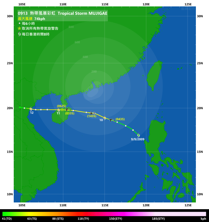
Figure 圖: (Track courtesy of Lorenzo. Data from HKO. 鳴謝 Lorenzo 提供路徑圖,資料取自天文台)
IR imagery animation 紅外線雲圖動畫:
TC track from HKWW 本站的熱帶氣旋路徑圖:
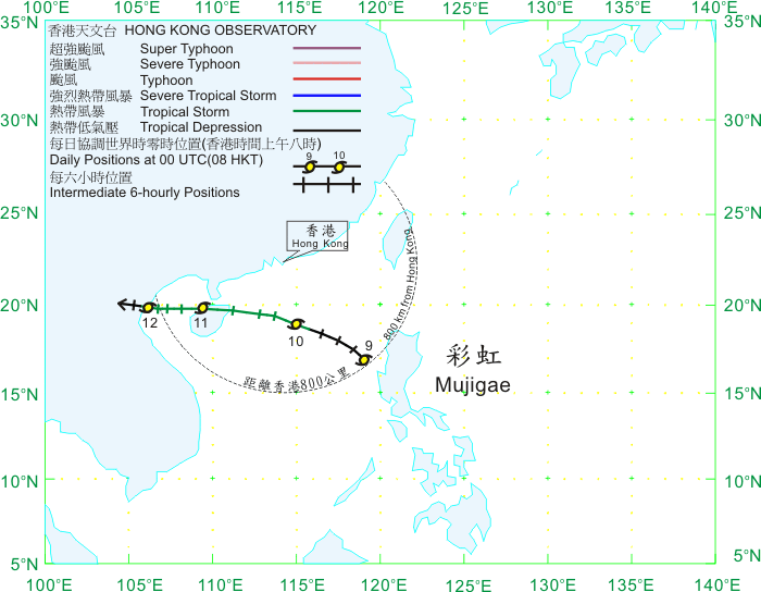
TC track from HKO 天文台的熱帶氣旋路徑圖:
| Past HKWW Bulletins on MUJIGAE 本站有關彩虹的發佈 |
Please click here for bulletins on MUJIGAE. 請按這裡。
| Storm Formation and Development 氣旋形成和發展 |
MUJIGAE is the 6th tropical cyclone that necessitated tropical cyclone signals in Hong Kong.
A disturbance developed just west of the Philippines on September 7th. It gathered strength on September 8th and intensified into a tropical depression on the next day (9th). Due to its rather rapid initial development, the JTWC directly upgraded the disturbance into tropical depression 14W without issuing a tropical cyclone formation alert in advance. Meanwhile, the HKO upgraded this low pressure area into tropical depression status at 06 HKT on September 9th.
14W moved north slowly at first, but turned to a WNW motion that night due to the steering from the western extension of the subtropical ridge. Although ambient environments were not hostile, 14W was only projected to attain tropical storm intensity at its peak due to its relatively fast speed in the South China Sea.
彩虹是本年第六個令天文台發出熱帶氣旋警告信號的熱帶氣旋。
一個熱帶擾動於 9 月 7 日在菲律賓以西發展,它於 8 日逐漸增強,並於 9 日增強成熱帶低氣壓。由於它初期發展頗為快速,聯合颱風警報中心在沒有發出熱帶氣旋形成警報的情況下直接升格該擾動為本年第 14 個熱帶低氣壓 (14W);本港天文台則於 9 日上午 6 時作出升格。
14W 初期向北緩慢移動。逐漸地,副熱帶高壓脊的駛流力量變得明顯,14W 當晚轉向西北偏西移動。雖然南海當時環境不俗,但由於 14W 移動快速,各大機構均預測 14W 只能於稍後達到熱帶風暴強度。
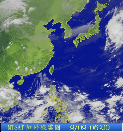
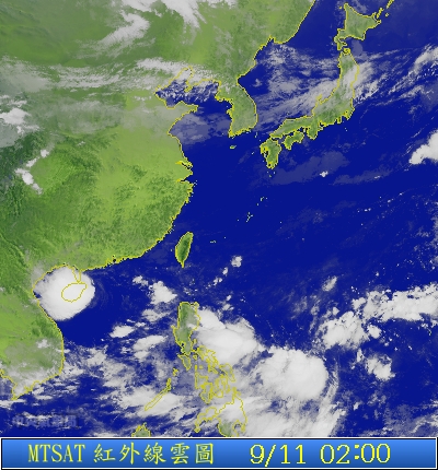
Figure 1 - Satellite imagery of the disturbance west of the Philippines when the HKO upgraded it into a tropical depression
圖 1 - 香港天文台升格菲律賓以西的低壓區為熱帶低氣壓時的衛星雲圖

Figure 2 - Warning bulletin #1 from the JTWC
圖 2 - 聯合颱風警報中心之第一次發佈

Figure 3 - HKO's initial forecast track
圖 3 - 香港天文台初次發出的預測路徑
| Issuance of Signals in Hong Kong 發出熱帶氣旋警告信號 |
14W's appearance improved on September 10th though most of its convections were still displaced to the west. As it continued to move closer to the territory, the Hong Kong Observatory issued the #1 Standby Signal at 04:35 HKT, adding that the chance of higher signals that morning was not high.
The JMA upgraded 14W into a tropical storm at 08 HKT and named it MUJIGAE. This name was contributed by North Korea, meaning rainbow. The name MUJIGAE was used for the first time, replacing MAEMI which devastated South Korea in 2003. As for MUJIGAE, the HKO upgraded it into tropical storm status at 11 HKT.
14W 的外觀於 10 日轉好,但大部分對流仍集中在環流中心的西面。隨著 14W 繼續移近本港,天文台於上午 4 時 35 分發出一號戒備信號,並稱該早改發三號強風信號的機會不大。
另一方面,日本氣象廳於上午 8 時升格 14W 為熱帶風暴,並將其命名為彩虹。彩虹一名由北韓提供,取代於同一位置的名稱鳴蟬。鳴蟬曾於 2003 年為南韓帶來重大破壞。天文台則於上午 11 時升格彩虹為熱帶風暴。

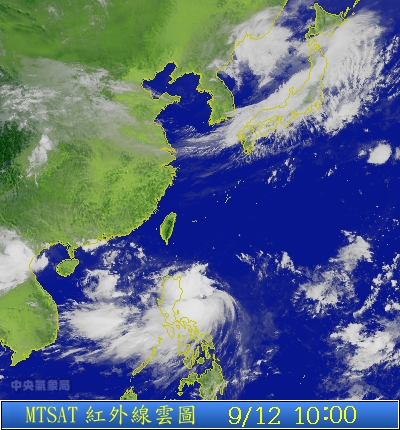
Figure 4 - Image of MUJIGAE, September 10th 10:30 HKT
圖 4 - 彩虹於 9 月 10 日上午 10 時 30 分的影像
At this time, MUJIGAE was speeding across the South China Sea, and the HKO's forecast track predicted a forward speed much lower than that actually observed. This prompted the Observatory to issue the #3 Strong Wind Signal at 14:35 HKT. The Education Bureau immediately announced that classes in kindergartens were to be suspended and parents, who just sent their children to schools for the afternoon session an hour or two before, needed to take them back home. The HKO was also criticized for "changing its mind" so quickly, as its earlier weather bulletins indicated that the #3 Signal would be considered later that afternoon.
這時彩虹正以高速橫過南海,而天文台的預測路徑則大幅落後。由於彩虹移速高,天文台於 10 日下午 2 時 35 分改發三號強風信號,而教育局隨即宣布幼稚園下午班停課。由於下午班只開課約一至兩小時,家長需要於短時間多次來回學校,因而惹來不滿。另外,由於天文台曾於較早時指出將於下午較後時間考慮改發三號信號,部分人士批評天文台太快改變主意。

Figure 5 - Steering chart at 14 HKT on September 10th
圖 5 - 9 月 10 日下午 2 時之駛流圖
MUJIGAE was actually closest to Hong Kong at 13 HKT, just before the #3 Signal was issued. It was 320 km south of Hong Kong with maximum wind speeds of 65 km/h near its centre.
As for local wind speeds, most stations saw a gradual increase near noon, and strongest winds were generally recorded in the afternoon and evening. Sustained strong winds were recorded in most offshore/high grounds stations and in some urban stations like Kai Tak, while sustained gale force winds were recorded in remote stations and some high ground stations like Waglan Island, Green Island, Ngong Ping and Tate's Cairn.
彩虹於 10 日下午 1 時三號信號未發出的時候最接近香港,當時位於香港以南約 320 公里,中心風力估計為每小時 65 公里。
至於本地風勢方面,大部分地區的風速於當天下午逐漸上升,而最高風速普遍於下午較後時間或當晚錄得。部分市區氣象站如啟德及大部分離岸和高地氣象站錄得持續強風,而偏遠地區和部分高地氣象站更錄到持續烈風 (如橫瀾島、昂坪和大老山)。


Figures 6a to 6c - Wind speed and wind direction in Hong Kong
圖 6a 至 6c - 香港各區之風速和風向


Figures 7a to 7c - Wind speeds on September 10th at Cheung Chau, Sai Kung and Waglan Island respectively
圖 7a 至 7c - 9 月 10 日 於長洲、西貢和橫欄島的風速
| Landfalls and Weakening 兩次登陸和減弱過程 |
Due to the relatively large distance between MUJIGAE and Hong Kong and the weak northeast monsoon, wind direction only changed slightly from northeast to east while MUJIGAE passed to the south of the territory, while winds in most places remained pretty strong until the early hours on September 11th. MUJIGAE made landfall at Wenchang in Hainan at about 02:20 HKT according to the China Meteorological Administration (CMA). Seeing the general decrease in wind speeds, the HKO replaced the #3 Signal by the #1 Standby Signal at 03:35 HKT and cancelled all signals at 06:25 HKT, when MUJIGAE was 450 and 490 km southwest of Hong Kong respectively.
MUJIGAE emerged from the northwestern side of Hainan Island after dawn that day and entered the Gulf of Tonkin as a minimal tropical storm, moving steadily to the west. It decelerated that night and made its second landfall at Thanh Hoa at about 10:20 HKT on September 12th. As MUJIGAE was a weak system throughout, it quickly weakened into a tropical depression (at 11 HKT) and subsequently into an area of low pressure that night. The rain brought by MUJIGAE provided some relief to southern China with below-normal rainfall in the past few months, yet avoiding significant losses due to its relatively low intensity.
由於彩虹跟香港距離尚遠,且華南沿岸正受微弱東北季候風的影響,彩虹於香港以南掠過時香港大部分地區的只由東北風轉吹東風,而偏強的風速持續至 11 日首數小時。根據中國氣象局的資料,彩虹於上午約 2 時 20 分於海南文昌登陸。隨著本港風勢逐漸減弱,天文台於上午 3 時 35 分改發一號戒備信號,而該信號亦於早上 6 時 25 分取消。當時彩虹分別於香港西南 450 公里和 490 公里。
彩虹在 11 日日出過後於海南島西北部進入北部灣,強度為弱熱帶風暴,並穩定向西移動。它於當晚減速,並於 12 日上午 10 時 20 分登陸越南清化。由於彩虹強度偏弱,它隨即於上午 11 時減弱為熱帶低氣壓,並於當晚減弱為一低壓區。彩虹於南海移動,為本年缺少雨水的華南地區帶來一些舒緩;而由於彩虹為一較弱的熱帶氣旋,它並未有帶來重大破壞。
Figures 8a and 8b - MUJIGAE making landfall at Hainan and northern Vietnam respectively
圖 8a 及 8b - 彩虹分別於海南和越南北部登陸時的情況
| Winds Recorded at Reference Stations 參考站所錄得的風速 |
| Station 風速站 |
Max. 10-min avg. wind speed 最高十分鐘平均風速 |
Beaufort classification 蒲福氏風級分類 |
| Chek Lap Kok 赤鱲角 | 40 km/h | Fresh 清勁 |
| Cheung Chau 長洲 | 57 km/h | STRONG 強風 |
| Kai Tak 啟德 | 42 km/h | STRONG 強風 |
| Sai Kung 西貢 | 48 km/h | STRONG 強風 |
| Sha Tin 沙田 | 24 km/h | Moderate 和緩 |
| Ta Kwu Ling 打鼓嶺 | 22 km/h | Moderate 和緩 |
| Tsing Yi (SHL) 青衣蜆殼油庫 | 22 km/h | Moderate 和緩 |
| Wetland Park 濕地公園 | 25 km/h | Moderate 和緩 |
| Number of stations recording at least STRONG force (force 6 - 7) winds: | 3 |
Number of stations recording at least GALE force (force 8 - 9) winds: |
0 |
| Number of stations recording at least STORM force (force 10 - 11) winds: | 0 |
| Number of stations recording HURRICANE force (force 12) winds: | 0 |
| 錄得 強風 (6 - 7 級) 或更高風速的站數: | 3 |
| 錄得 烈風 (8 - 9 級) 或更高風速的站數: | 0 |
| 錄得 暴風 (10 - 11 級) 或更高風速的站數: | 0 |
| 錄得 颶風 (12 級) 風速的站數: | 0 |
| Charts and Figures 各項數據 |
Table 1: Track data from HKWW:
表一 : 香港天氣觀測站之路徑資料
| YYMMDDZZ Lat Long Wind 09090818 168N1185E 020 09090900 170N1182E 025 09090906 175N1184E 030 09090912 180N1175E 035 09090918 183N1165E 035 09091000 189N1150E 040 09091006 194N1138E 040 09091012 196N1127E 040 09091018 197N1112E 040 09091100 198N1095E 040 09091106 198N1080E 040 09091112 198N1072E 040 09091118 198N1063E 040 09091200 198N1062E 035 09091206 198N1055E 030 |
Table 2: Maximum gust and 60-minute average wind speed recorded in Hong Kong from HKO:
表二 : 香港天文台公佈的各站最高 60 分鐘平均風力和陣風數據
Maximum Gust |
Maximum Hourly Wind |
|||||||
| Station | Direction |
Speed (km/h) |
Date/Month |
Time |
Direction |
Speed (km/h) |
Date/Month |
Time |
Bluff Head (Stanley) |
ENE |
79 |
10/9 |
18:03 |
ENE |
43 |
10/9 |
20:00 |
Central Pier |
E |
67 |
10/9 |
20:07 |
E |
47 |
10/9 |
17:00 |
Cheung Chau |
ESE |
79 |
10/9 |
20:28 |
E |
51 |
10/9 |
22:00 |
Cheung Sha Wan |
E |
52 |
10/9 |
19:21 |
E |
20 |
10/9 |
17:00 |
Green Island |
NE |
96 |
10/9 |
16:17 |
NE |
65 |
10/9 |
17:00 |
Hong Kong International Airport |
E |
56 |
10/9 |
20:44 |
E |
36 |
10/9 |
23:00 |
Kai Tak |
E |
72 |
10/9 |
20:04 |
E |
34 |
10/9 |
17:00 |
King's Park |
ESE |
62 |
10/9 |
18:27 |
E |
25 |
10/9 |
21:00 |
Lau Fau Shan |
E |
56 |
10/9 |
17:22 |
E |
30 |
10/9 |
14:00 |
Ngong Ping |
ENE |
110 |
10/9 |
19:44 |
E |
77 |
10/9 |
21:00 |
North Point |
E |
72 |
10/9 |
16:14 |
E |
36 |
10/9 |
20:00 |
|
E |
36 |
10/9 |
21:00 |
||||
Ping Chau |
E |
56 |
10/9 |
20:42 |
E |
14 |
10/9 |
20:00 |
|
E |
14 |
10/9 |
22:00 |
||||
Sai Kung |
ENE |
62 |
10/9 |
19:23 |
ENE |
41 |
10/9 |
21:00 |
Sha Chau |
E |
56 |
10/9 |
17:14 |
E |
38 |
10/9 |
18:00 |
Sha Lo Wan |
E |
68 |
10/9 |
18:57 |
E |
38 |
10/9 |
19:00 |
Sha Tin |
E |
51 |
10/9 |
18:18 |
ENE |
20 |
10/9 |
21:00 |
E |
51 |
10/9 |
19:30 |
|||||
Shek Kong |
ESE |
62 |
10/9 |
16:39 |
E |
23 |
11/9 |
02:00 |
Star Ferry (Kowloon) |
E |
63 |
10/9 |
16:02 |
E |
34 |
10/9 |
17:00 |
Ta Kwu Ling |
E |
49 |
10/9 |
20:33 |
E |
19 |
10/9 |
18:00 |
E |
49 |
10/9 |
20:38 |
E |
19 |
10/9 |
21:00 |
|
ENE |
49 |
10/9 |
21:01 |
|||||
Tai Mei Tuk |
E |
75 |
10/9 |
17:07 |
E |
49 |
10/9 |
22:00 |
Tai Mo Shan |
E |
88 |
10/9 |
21:22 |
E |
56 |
10/9 |
22:00 |
Tap Mun |
E |
59 |
10/9 |
17:11 |
E |
30 |
10/9 |
07:00 |
Tate's Cairn |
ESE |
87 |
10/9 |
18:22 |
ESE |
59 |
10/9 |
22:00 |
Tsak Yue Wu |
E |
49 |
10/9 |
19:19 |
ENE |
16 |
10/9 |
14:00 |
Tseung Kwan O |
ENE |
52 |
10/9 |
16:59 |
NNE |
19 |
10/9 |
11:00 |
Tsing Yi Shell Oil Depot |
E |
45 |
10/9 |
13:40 |
ESE |
19 |
10/9 |
17:00 |
ESE |
45 |
10/9 |
16:27 |
|||||
Tuen Mun Government Offices |
NNE |
49 |
10/9 |
13:29 |
NNE |
19 |
10/9 |
11:00 |
Waglan Island |
E |
83 |
10/9 |
17:59 |
E |
67 |
10/9 |
16:00 |
Wetland Park |
ESE |
43 |
10/9 |
17:47 |
E |
22 |
10/9 |
18:00 |
Wong Chuk Hang |
E |
65 |
10/9 |
16:12 |
E |
31 |
10/9 |
20:00 |
Table 3: Rainfall contributed by MUJIGAE from HKO (figures in brackets are based on incomplete hourly data):
表三 : 香港天文台公佈的各站雨量資料 (方括號內之數據由不完整之每小時資料擷取)
Station |
10 Sep |
11 Sep |
Total |
|
Hong Kong Observatory |
0.9 |
11.8 |
12.7 |
|
Cheung Chau (CCH) |
1.5 |
12.0 |
13.5 |
|
Hong Kong International Airport (HKA) |
0.3 |
14.6 |
14.9 |
|
N13 |
High Island |
0.0 |
1.0 |
1.0 |
K04 |
Jordan Valley |
0.0 |
6.5 |
6.5 |
N06 |
Kwai Chung |
1.0 |
5.0 |
6.0 |
H12 |
Mid Levels |
2.5 |
23.5 |
26.0 |
H21 |
Repulse Bay |
1.0 |
43.5 |
44.5 |
SHA |
Sha Tin |
0.0 |
3.5 |
3.5 |
H19 |
Shau Kei Wan |
1.5 |
9.5 |
11.0 |
SEK |
Shek Kong |
1.0 |
5.0 |
6.0 |
K06 |
So Uk Estate |
0.5 |
9.0 |
9.5 |
R31 |
Tai Mei Tuk |
0.0 |
1.0 |
1.0 |
R21 |
Tap Shek Kok |
0.0 |
3.0 |
3.0 |
N17 |
Tung Chung |
2.0 |
32.0 |
34.0 |
R27 |
Yuen Long |
0.0 |
2.0 |
2.0 |
Last Accessed 最近訪問日期: Sun Sep 08 2024 12:37:40 HKT
Last Modified 最近修訂日期: Mon Jul 24 2023
