
TC Watch / 熱帶氣旋 > Selected TC Review / 重要熱帶氣旋回顧 > 200907W (MOLAVE 莫拉菲) [Refresh 更新]
 200907W (MOLAVE 莫拉菲) - Profile 檔案 200907W (MOLAVE 莫拉菲) - Profile 檔案 |
(First draft issued on July 29th, 2009; final version issued on August 19th, 2009)
(中文初稿於 2009 年 7 月 29 日發出,最後版本於 8 月 19 日上載)
Brief profile of MOLAVE 莫拉菲小檔案:
| JTWC number 聯合颱風警報中心 (JTWC) 號碼 | 07W |
| International number 國際編號 | 0906 |
| Period of existence 生存時期 | 15 July, 2009 14 HKT to 19 July, 2009 08 HKT |
| Lifetime 壽命 | 3.75 days 日 |
| Maximum 1-minute wind (JTWC) JTWC 一分鐘平均最高中心風速 | 65 knots 節 (Category 1 Typhoon 一級颱風) |
| Minimum pressure (JTWC) JTWC 最低氣壓 | 977 hPa 百帕* |
| Highest TC signal by HKO (if applicable) 香港天文台發出最高熱帶氣旋警告信號 |
9 (Increasing Gale or Storm Signal 烈風或暴風增強信號) |
| Closest point of approach by HKO (if applicable) 香港天文台所示之最接近距離 (如適用) |
N 40 km 公里 (real-time warning 實時報告) / NNE 40km 公里 (TC report 熱帶氣旋報告) |
| Time of closest approach by HKO (if applicable) 香港天文台所示之最接近時間 (如適用) |
19 July, 2009 03 HKT (real-time warning 實時報告) / 02-03 HKT (TC report 熱帶氣旋報告) |
| Lowest pressure recorded at HKO (if applicable) 香港天文台錄得的最低氣壓 (如適用) |
985.6 hPa 百帕 (19 July, 2009 01:52 to 01:58 HKT) |
*This pressure from the JTWC is deemed unrepresentative, as the minimum pressure recorded at the Sanmen Islands (沱濘列島 / 大小三門島) just prior to landfall was 968.7 hPa. 由於莫拉菲登陸前沱濘列島曾錄得 968.7 百帕之氣壓,因此 JTWC 所估算的最低氣壓 (977 百帕) 並沒有代表性。
TC signals for Hong Kong & Track 香港曾經生效的熱帶氣旋警告和路徑圖:
Table 表:
| Signal 信號 |
Date and time 日期和時間 |
Distance from HK 與香港的距離 |
Predicted movement 預測移動方向和速度 |
Max. 10-min winds 中心最高十分鐘平均風速 |
 |
2009/07/17 (FRI) 22:15 HKT | ESE 700 km | WNW at 20 km/h | 112 km/h (60 knots, STS) |
 |
2009/07/18 (SAT) 14:15 HKT | ESE 310 km | WNW at 22 km/h | 130 km/h (70 knots, CAT. 1 / TY^) |
 |
2009/07/18 (SAT) 23:30 HKT | E 100 km | WNW at 24 km/h | 139 km/h (75 knots, CAT. 1 / TY^) |
 |
2009/07/19 (SUN) 01:30 HKT | ENE 70 km | WNW at 25 km/h | 121 km/h (65 knots, CAT. 1 / TY^) |
 |
2009/07/19 (SUN) 04:40 HKT | WNW 80 km | W/WNW at 25 km/h | 103 km/h (55 knots, STS) |
|
2009/07/19 (SUN) 06:40 HKT | WNW 110 km | W at 25 km/h | 103 km/h (55 knots, STS) |
|
2009/07/19 (SUN) 10:40 HKT | WNW 200 km | W at 25 km/h | 75 km/h (40 knots, TS) |
 |
2009/07/19 (SUN) 13:15 HKT | WNW 260 km | W at 25 km/h | 56 km/h (30 knots, TD) |
^Storms having central wind speeds of above 117 km/h (63 knots) are classified using HKO's new TC classification system, with the addition of Severe Typhoon and Super Typhoon categories. 中心風力高於每小時 117 公里 (63 節) 的熱帶氣旋的分級依循香港天文台的新分級制度;該制度把颱風一級細分為颱風、強颱風和超強颱風。
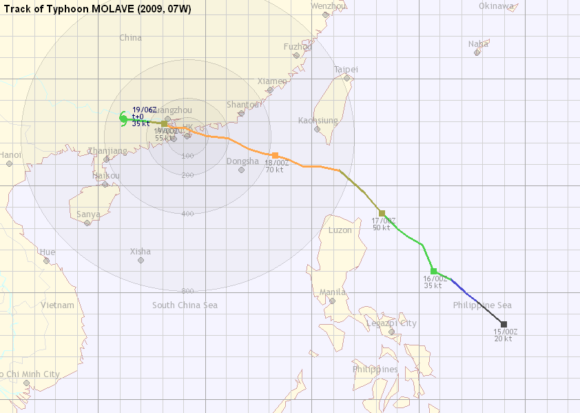
Figure 圖: (Track courtesy of Lorenzo. Data from HKO. 鳴謝 Lorenzo 提供路徑圖,資料取自天文台)

IR imagery animation 紅外線雲圖動畫:
TC track from HKWW 本站的熱帶氣旋路徑圖:
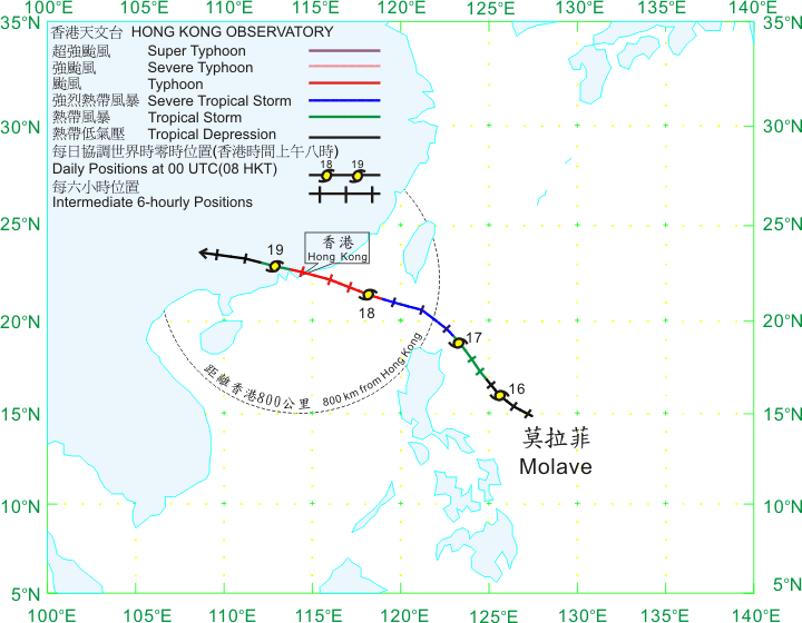
TC tracks from HKO 天文台的熱帶氣旋路徑圖:
| Past HKWW Bulletins on MOLAVE 本站有關莫拉菲的發佈 |
Please click here for bulletins on MOLAVE. 請按這裡。
| Storm Formation and Development 氣旋形成和發展 |
MOLAVE was the third cyclone to form within the active ITCZ (mentioned in the report on 05W SOUDELOR). Its proximity to Hong Kong led to the first #8 and #9 Signals of the year, making the #9 Signal necessary in two consecutive years. MOLAVE was also the fourth consecutive named tropical cyclone that necessitated TC signals in the territory, and was the strongest cyclone to pass within 100 km from Hong Kong since Typhoon Dujuan in 2003.
A low pressure area was identified on July 10th near Yap, but remained poorly developed probably because of other low pressure areas competing resources with it. On July 13th, after the disappearance of other disturbances and 06W moved towards Taiwan, this disturbance (91W) quickly consolidated and a tropical cyclone formation alert (TCFA) was issued by the JTWC at 02 HKT on July 14th. It was extended on July 15th as the storm moved NW in the Philippine Sea.
As its structure continued to improve, the JTWC upgraded 91W into tropical depression 07W at 14 HKT on July 15th. The subtropical ridge was anchored NE of the system and was extending westwards, which led to the prediction of a NW track followed by WNW movement towards areas near Hong Kong.
The HKO upgraded 07W to tropical depression status in its weather report issued at 20:45 HKT the same day. Initial development was a bit slow, and it took one full day for the system to intensify into a tropical storm, with the JMA naming it MOLAVE at 20 HKT on July 16th. MOLAVE, contributed by the Philippines, is a popular hard wood used in the production of furniture. It replaced the name IMBUDO at the same position on the list due to the heavy casualties resulted in 2003 (IMBUDO necessitated the #8 Signal in Hong Kong). All agencies were very consistent and put an initial landfall very close to Hong Kong, although they expected that the vertical wind shear would heighten as the storm moved towards the South China Sea, and consequently estimated a rather low intensity in their forecasts.
莫拉菲為七月初活躍的熱帶輻合帶所發展出的第三個熱帶氣旋,並令天文台發出本年首個八號和九號熱帶氣旋警告信號,亦令天文台於連續兩年均需發出九號信號。同時,莫拉菲為本年第四個影響香港的熱帶氣旋,亦為自 2003 年颱風杜鵑以來正面吹襲本港的最強颱風。
一個低壓區在 7 月 10 日於雅蒲島附近形成,但由於多股擾動在其附近爭奪資源,於其後兩天該低壓區並沒有發展起來。13 日 06W 登陸台灣,而其他擾動也逐漸消散,令這低壓 (91W) 快速整固,JTWC 因而於 14 日早上 2 時發出熱帶氣旋形成警報。該警報於次日延續,91W 於此時逐漸向西北移動,橫過菲律賓以東海域。
91W 的結構繼續變好,JTWC 於 15 日升格 91W 為熱帶低氣壓 07W。當時副熱帶高壓脊正位於 07W 東北面,並預期會西伸,因而首報的預測路徑已經預計 07W 會向西北轉西北偏西移動,趨向香港附近海域。
香港天文台於同日晚上 8 時 45 分把 07W 升格為熱帶低氣壓。該熱帶氣旋初期發展速度頗慢,用了一整天才增強成熱帶風暴。日本氣象廳於 16 日下午 8 時作出升格,並把其命名為莫拉菲。莫拉菲一名由菲律賓提供,為當地用來製造傢俬的硬木。它代替於同位置的熱帶氣旋名稱伊布都;伊布都曾於 2003 年為東南亞帶來巨大破壞,亦曾令本港發出八號信號。在對莫拉菲的預測路徑中,各站均把登陸點指向香港附近;但由於預計南海的垂直風切變將有所增強,強度估算較為保守。
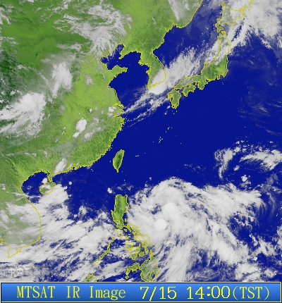
Figure 1 - IR imagery of 07W at its formation
圖 1 - 07W 形成時之紅外線衛星雲圖

Figure 2 - Steering chart at the appropriate level, 14 HKT on July 15th
圖 2 - 7 月 15 日下午 2 時之駛流圖

Figure 3 - Warning bulletin #1 from JTWC at 14 HKT on July 15th
圖 3 - JTWC 於 7 月 15 日下午 2 時發出的首份路徑圖
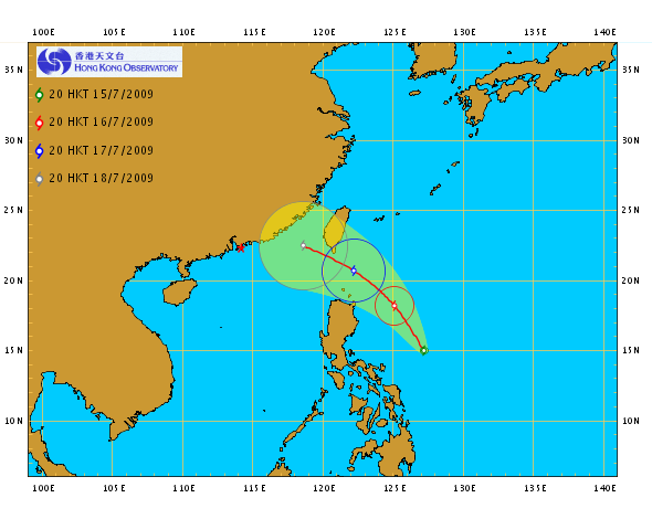
Figure 4 - HKO's first forecast track
圖 4 - 天文台的首份預測路徑圖
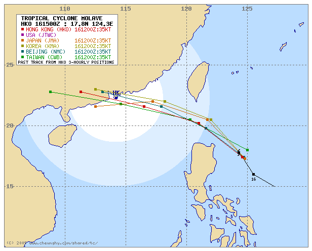
Figure 5 - Forecast tracks from various agencies
圖 5 - 各台預測路徑圖
| MOLAVE's Intensification and Its Journey into the South China Sea 莫拉菲的增強和踏進南海的過程 |
Vertical wind shear was moderate at where MOLAVE's circulation centre was situated, but the shear in its southern periphery was increasing. As a result, MOLAVE's cloud bands were concentrated to the west, and it took quite some time for the eastern bands to develop. MOLAVE continued to strengthen in the night of July 16th and early July 17th, and by the afternoon it was upgraded to severe tropical storm status by the JMA; HKO also followed shortly. The storm was drifting NW to NNW and was able to avoid the Luzon landmass. MOLAVE was trying to form a banding eye at that moment.
莫拉菲中心附近的垂直風切變較弱,但其南部的垂直風切變則逐漸增強,結果令其雲團向西面切離,要用一段頗長的時間才能於東面發展出有組織的螺旋雲帶。莫拉菲於 16 日晚上和 17 日早期繼續增強,於 17 日下午被日本氣象廳升格為強烈熱帶風暴。香港天文台也於短時間後跟隨。由於莫拉菲向西北至西北偏北移動,它能避過呂宋北部的陸地,逐漸移近呂宋海峽;它亦開始嘗試發展一雲捲風眼。

Figure 6 - Wind shear distribution, 14 HKT on July 16th. Note the difference between the wind shear (indicated by the colour) north and south of MOLAVE.
圖 6 - 垂直風切變分布圖。留意莫拉菲以北和以南之風切變的分別 (由顏色區分)

Figure 7 - Visible imagery of MOLAVE at 14:30 HKT, July 17th. MOLAVE was trying to form an eye.
圖 7 - 7 月 17 日下午 2 時 30 分的可見光衛星雲圖。莫拉菲當時正嘗試建立風眼
As MOLAVE reached Luzon Strait in the night of July 17th, it succeeded in wrapping its convections around its northern semicircle. It finally developed an eye visible in IR imagery and, much more clearly, in Taiwan's RADAR images. The storm was entering South China Sea, and the Observatory issued the #1 Standby Signal at 22:15 HKT that night. As MOLAVE was expected to be quite close to Hong Kong later, the media generally paid much more attention even when only the Standby Signal was issued.
莫拉菲終於在 17 日晚到達呂宋海域時捲起北面的雲團,並發展出風眼,於紅外線衛星影像和台灣所提供的雷達影像均可看到。隨著莫拉菲進入南海北部,天文台於當晚 10 時 15 分發出一號戒備信號。縱使莫拉菲跟香港尚有一段距離,但由於預料莫拉菲將於稍後頗為接近香港,傳媒均非常留意該熱帶氣旋的發展。
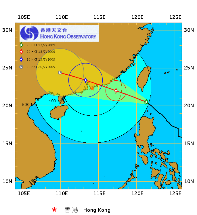
Figure 8 - HKO's forecast track, July 17th 20 HKT
圖 8 - 香港天文台於 7 月 17 日下午 8 時的預測路徑圖
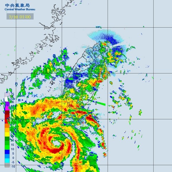
Figure 9 - RADAR image at 01 HKT on July 18th. MOLAVE has already developed an eye.
圖 9 - 7 月 18 日下午 1 時的雷達影像。莫拉菲已擁有一風眼
Meanwhile, MOLAVE had taken a turn to the WNW as it approached the southern periphery of the western extension of the steering subtropical ridge. Convections continued to burst overnight, filling the empty SW parts of the eye. The eye was continuously discernible in RADAR images until its landfall, and therefore positioning the storm had become a fairly simple business.
MOLAVE moved to within 500 km from Hong Kong near sunrise on July 18th. Due to the heavy subsidence just west of the system, Hong Kong experienced very hot and hazy weather with very stagnant air. Locally temperatures at almost all stations surged past the 33-degree mark in the afternoon. Tuen Mun recorded 37.0 degrees at about 14:30 HKT, while the Observatory registered the highest temperature of the year so far at 34.3 degrees, measured at almost the same time. Although MOLAVE's wind radii were relatively small, the Observatory provided ample warning to the local public as it issued the #3 Strong Wind Signal at 14:15 HKT, when the storm was 310 km ESE of Hong Kong.
Temperatures dropped sharply to below 30 degrees when MOLAVE's the first rain band arrived at about 15:30 HKT, sweeping past the territory from east to west. Gusts were observed at that time but were short-lived. Winds remained relatively light in the territory after night set in, and therefore large crowds were seen in many areas just like usual Saturday nights.
與此同時,莫拉菲到達副高西部延伸的南面,並開始轉向西北偏西移動。莫拉菲附近於 18 日凌晨不斷有對流爆發,終能填補莫拉菲風眼西南部早前少雲的地方。由於莫拉菲的風眼至登陸時仍能於雷達圖清晰可見,定位相對變得較易。
莫拉菲於 18 日近日出時移至香港 500 公里以內。受到其西部強下沉氣流的影響,香港於該日上半部經歷酷熱有煙霞的天氣。本地幾乎各氣象站均於當天下午錄得超過 33 度的氣溫。天文台於下午 2 時 30 分左右錄得本年至今最高氣溫 34.3 度,而屯門的氣溫更於差不多時間升至 37.0 度。由於莫拉菲的風圈較細,雖然本地風速尚未增強,天文台亦於下午 2 時 15 分改發三號強風信號,以警惕市民。當時莫拉菲於香港東南偏東約 310 公里處。
莫拉菲外圍的第一道雨帶於約下午 3 時 30 分到達香港,並由東向西掃過,本地氣溫因而普遍下降至 30 度以下。多處曾錄到強勁陣風,但很快便回復平靜。入夜後風勢仍然偏弱,加上由於當日為週六,因此市面繁華依然,市民如常外出。


Figures 10a and 10b - Temperature and humidity readings at Tuen Mun and Hong Kong Observatory respectively
圖 10a 至 10b - 屯門和香港天文台的溫度濕度時間序列圖
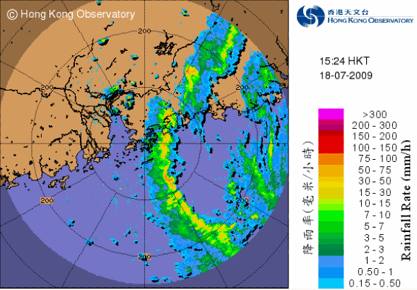
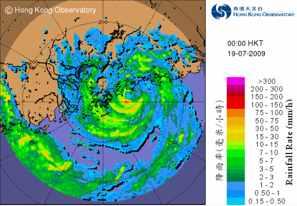
Figure 11 - MOLAVE's first outer rain band approaching Hong Kong
圖 11 - 莫拉菲第一道外圍雨帶開始影響本港
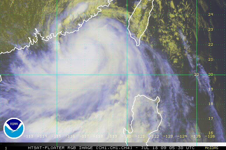
Figure 12 - Satellite image taken at 13:30 HKT on July 18th
圖 12 - 7 月 18 日下午 1 時 30 分的衛星雲圖
The Observatory added forces 9 to 10 winds in their 7-day weather forecast, and the South China coastal waters bulletin indicated that force 12 winds might be observed in Hong Kong adjacent waters. These could serve as implications that the #8 Signal was imminent. The Observatory finally issued the Pre-No. 8 Special Announcement at 21:30 HKT indicating that higher signals would be required at most two hours later. Local ferry services were already suspended earlier, while sea transport between Hong Kong and Macao were suspended at about 23 HKT.
Making use of the full two-hour warning period, the Observatory issued the #8 Northwest Gale or Storm Signal at 23:30 HKT. The storm was reported to be only 100 km east of Hong Kong (but appeared to be closer on RADAR images), and locally wind picked up shortly after 23 HKT.
天文台於七天天氣預報中加上達 10 級的風力預測,其華南海域天氣報告更預計香港鄰近海域將吹 12 級颶風,可見八號信號幾乎肯定會發出。最終天文台於晚上 9 時 30 分發出預警八號熱帶氣旋警告信號之特別報告,表示兩小時內會改發更高信號。本地渡輪服務已於較早時暫停,而港澳間的水路交通亦於大約晚上 11 時暫停。
天文台於當晚 11 時 30 分,亦即兩小時預警過後發出八號西北烈風或暴風信號。根據天文台的定位,莫拉菲當時只於香港以東 100 公里 (但從雷達上看,實際距離可能更近);風勢亦於八號信號發出後不久迅速增強。
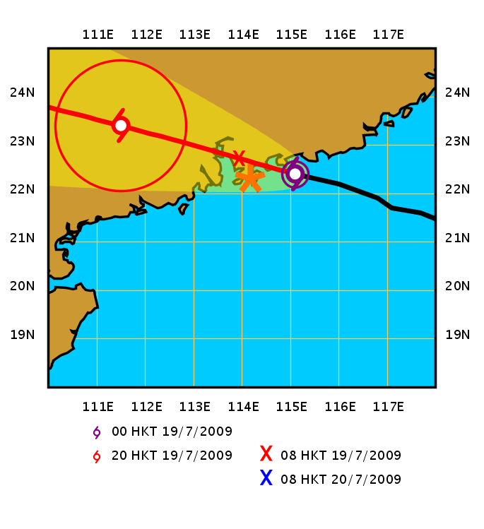
Figure 13 - MOLAVE's position and forecast track shortly after the #8 Signal was issued
圖 13 - 莫拉菲於八號信號發出後不久的位置和預測路徑
| MOLAVE's Landfall and Conditions in Hong Kong 莫拉菲的登陸和香港的情況 |
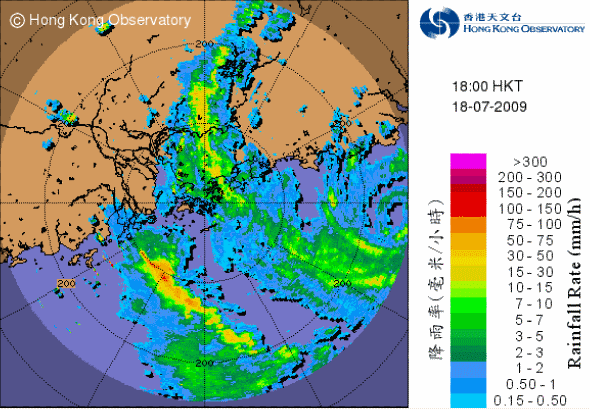
MOLAVE turned due west shortly as it reached south of Huilai (惠來), but land interactions caused a series of northward jogs just as it passed south of Honghai Bay (紅海灣). Just several tens of minutes before landfall, Sanmen Islands (which were very close to MOLAVE's centre) recorded a pressure of 968.7 hPa, justifying the claim that MOLAVE made landfall as a typhoon. It finally made landfall at Dapeng Peninsula at about 00:50 HKT on July 19th. Winds in some stations in Hong Kong reached gale force, and being the station in Hong Kong (whose data were available to the public) closest to the storm's centre, Tap Mun registered a maximum 10-minute average wind speed of 96 km/h, with gusts reaching 148 km/h. The Observatory then issued the #9 Increasing Gale or Storm Signal at 01:30 HKT, indicating that winds would continue to strengthen and gradually change to SW, and flooding could occur in low-lying areas. Hong Kong was also hit by the intense rain bands in MOLAVE's southern eyewall, and the Amber Rainstorm Warning was issued at 01:45 HKT.
As the storm moved towards Mirs Bay and subsequently north of Hong Kong, sea level pressures at some stations plunged to the lowest level since the passage of Dujuan just north of Hong Kong in September 2003; Tai Po, Ta Kwu Ling and Sheung Shui recorded minimum sea level pressures below 980 hPa, while Sha Tou Kok station's barometer read 974.1 hPa just shortly after 02 HKT. Heavy rain continued to fall and the rainstorm warning was raised to red at 02:25 HKT.
Winds in most parts of the territory turned to southwesterlies after 02:30 HKT, and Waglan Island recorded maximum wind speed of 103 km/h. The storm was closest to Hong Kong at about 03 HKT when it was situated 40 km north of the Observatory. At that time, MOLAVE had been overland for more than 2 hours, and the eye was quickly filled with clouds and its structure worsened as seen on RADAR. The Observatory replaced the #9 Signal with the #8 Southwest Gale or Storm Signal at 04:40 HKT when winds over Hong Kong stopped strengthening.
路徑方面,莫拉菲於到達惠來以南海域後開始向偏西移動,但受到附近陸地影響,它於經過紅海灣以南時出現多次北跳情況。登陸前沱濘列島曾錄得 968.7 百帕之氣壓,大致確定莫拉菲颱風之強度。最後莫拉菲於 19 日凌晨約 12 時 50 分登陸大鵬半島。本港部分地區錄得烈風或以上程度之風速;距離莫拉菲最近之一的塔門站錄得最高 10 分鐘持續風速達每小時 96 公里,陣風達每小時 148 公里。鑒於風勢將可能繼續增強,天文台於上午 1 時 30 分改發九號烈風或暴風增強信號。同時,香港受莫拉菲南面強烈的雨帶影響,多處傾盆大雨,天文台遂於 1 時 45 分發出黃色暴雨警告信號,並提醒市民低窪地區可能會水浸。
隨著莫拉菲向大鵬灣及香港以北進發,本港多個氣象站錄得自 2003 年 9 月杜鵑襲港以來最低的海平面氣壓,大埔、打鼓嶺和上水站均錄得海平面氣壓低於 980 百帕,而沙頭角更於上午 2 時前錄得 974.1 百帕。由於大雨持續,天文台於上午 2 時 25 分改發紅色暴雨警告信號。
上午 2 時 30 分過後,本港大部分地區的風向逐步由西北轉向西南,而橫欄島則錄得最高風速為每小時 103 公里。根據天文台發出的天氣稿,莫拉菲於上午 3 時最接近香港,當時於天文台以北約 40 公里。那時莫拉菲登陸已逾兩小時,其風眼開始被雨雲填滿,從雷達上看它的組織亦逐漸變差。天文台於上午 4 時 40 分發出八號西南烈風或暴風信號,表示風勢已停止增強。


Figures 14a to 14f - MOLAVE as seen on RADAR. Images were taken at 18, 20 and 22 HKT of July 18th, and 00, 02 and 04 HKT of July 19th. MOLAVE's eye was clearly visible on the first three images.
圖 14a 至 14f - 7 月 18 日下午 6 、8 和 10 時,以及 19 日凌晨 12 、上午 2 和 4 時之雷達圖。莫拉菲的風眼於頭三幅圖片上清晰可見
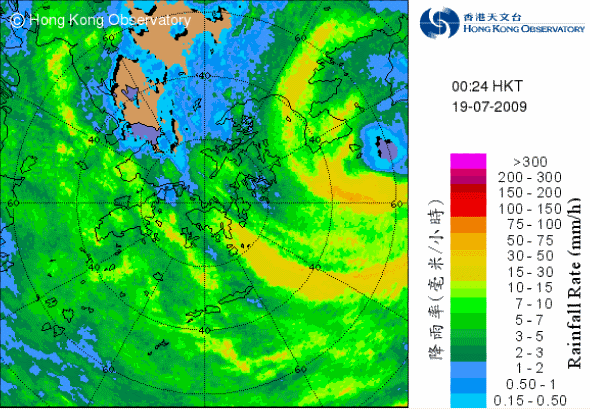
Figure 15 - 64-km range RADAR showing MOLAVE just before landfall at Dapeng Peninsula. The eye is clearly discernible on this image.
圖 15 - 64 公里範圍的雷達圖。莫拉菲的風眼清晰可見


Figures 16a to 16f - Wind directions and speeds across Hong Kong at 18, 20 and 22 HKT of July 18th, and 00, 02 and 04 HKT of July 19th.
圖 16a 至 16f - 7 月 18 日下午 6 、8 和 10 時,以及 19 日凌晨 12 、上午 2 和 4 時之風向和風速分布圖

Figure 17 - Wind speed recorded at Tap Mun, one of the HK stations closest to the centre of MOLAVE
圖 17 - 塔門錄得的風速


Figures 18a to 18d - Mean sea level pressure readings at Hong Kong Observatory, Ta Kwu Ling, Tai Po and Sha Tau Kok
圖 18a 至 18d - 香港天文台、打鼓嶺、大埔和沙頭角的氣壓讀數
| Weakening and Eventual Dissipation 減弱和消散 |
After it traversed Shenzhen, MOLAVE was downgraded into a severe tropical storm in the tropical cyclone bulletin for 06 HKT; the Red Rainstorm Warning was also cancelled at 05:30 HKT as the most intense rain bands progressed westward. Just after two hours of issuance, the #8 Signal was replaced by the #3 Strong Wind Signal at 06:40 HKT, and four hours later the #1 Standby Signal was issued as winds continued to dwindle. All signals were cancelled at 13:15 HKT as MOLAVE ceased to produce any threat to the territory. On the other hand, MOLAVE quickly weakened into a tropical storm at 09 HKT, and further into a tropical depression in the 16 HKT bulletin.
橫過深圳後,天文台於上午 6 時把莫拉菲降格為強烈熱帶風暴;由於雨勢轉弱,紅色暴雨警告信號也於上午 5 時 30 分解除。隨著風勢進一步減弱,八號信號於上午 6 時 40 分被三號強風信號取代,並於 4 小時後降為一號戒備信號。所有熱帶氣旋警告信號於下午 1 時 15 分取消。另一方面,莫拉菲先於上午 9 時減弱為熱帶風暴,再於下午 4 時進一步減弱為熱帶低氣壓。

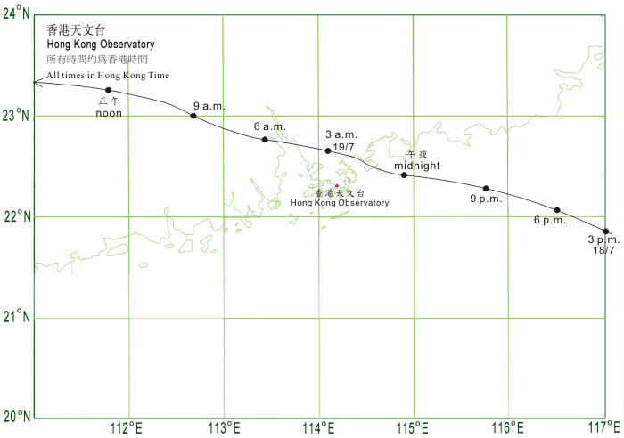
Figure 19 - Track of MOLAVE near Hong Kong. Note that the positions near midnight were severely lagged, compared with the mainland's observation of landfalling at around 00:50 HKT on July 19th.
圖 19 - 莫拉菲接近香港時的路徑。和中國內地所表示的於 12 時 50 分登陸比較,香港天文台的定位落後一大截
MOLAVE then quickly moved to the west, and the cloud bands continued to dissipate. The final tropical cyclone warning for shipping was issued at 16 HKT, and MOLAVE was downgraded to an area of low pressure at 02 HKT on July 20th.
莫拉菲迅速向西移動,其雲帶亦繼續消散。天文台於下午 4 時對其發出最後一份船舶熱帶氣旋警報,而莫拉菲亦於 20 日上午 2 時減弱為一低壓區。
| Damage to Hong Kong and Further Remarks 莫拉菲於香港造成的破壞和一些備註 |
Although winds strengthened very rapidly as MOLAVE neared, the damage it caused to Hong Kong was relatively light. There were a total of 62 reports of falling trees and 5 people were sent to hospital with minor injuries. This was mostly due to MOLAVE passing north of Hong Kong; as Hong Kong was situated within the navigable semicircle, winds were lighter than if it travelled to the south of the territory; also due to topographical reasons, it was much more difficult for westerly or northwesterly winds to attain high speeds than easterly winds. If MOLAVE passed south of Hong Kong, stations including Waglan Island and Cheung Chau might have a chance of recording hurricane force winds (reduced to sea level), and the #10 Signal might be required.
Heavy precipitation was recorded in Hong Kong as MOLAVE's heaviest rain bands were situated in its southern semicircle. The Landslip Warning and the Special Announcement on Flooding in the Northern New Territories were issued in the small hours of July 19th, and rainfall in most parts of the territory surpassed 100 mm that day.
雖然風勢於 18 日晚迅速增強,莫拉菲於香港時所造成的破壞相對輕微。政府共接獲 62 宗塌樹報告,而風暴期間 5 人因受輕傷而被送院。香港所受破壞輕微,主要因為莫拉菲於香港以北掠過;當時香港處於可航半圓,而同時由於香港北面普遍受到屏蔽,風暴所帶來的西北風相對較弱。如莫拉菲於香港以南掠過,長洲和橫欄島等南部離岸地區將有可能受強勁偏東風吹襲,根據莫拉菲的登陸強度,加上香港東面相對空曠,屆時該等地區極有可能受颶風影響,或需發出更高信號。
由於莫拉菲的雨帶集中於南部,當它於香港北面掠過,其雨帶為本港帶來可觀的雨量。山泥傾瀉警告和新界北部水浸特別報告亦於 19 日首數小時發出。本港普遍地區於當天錄得超過 100 毫米雨量。
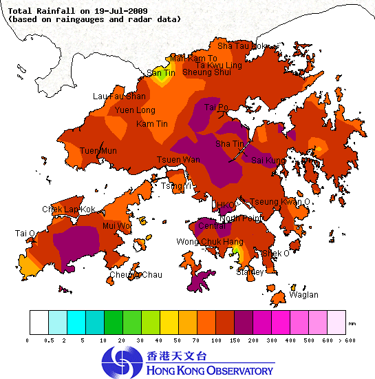
Figure 20 - Isohyet chart for July 19th
圖 20 - 7 月 19 日之等雨量線圖
It is worthwhile to note that although gale force winds were recorded on the bridges between Macau Peninsula and Taipa, only the Strong Wind Signal was hoisted there. Also the Central Weather Bureau of Taiwan (CWB) failed to issue the "land warning for typhoon" even though MOLAVE's force 7 wind circle is believed to have touched the island, and CWB's positions were generally to the south of that from other agencies.
值得留意的是雖然不只一條連接澳門半島與氹仔的大橋曾錄得烈風,當地卻只掛上三號風球;台灣方面,當局認為莫拉菲的七級風圈並未觸及陸地而無須發出陸上颱風警報,而台灣對莫拉菲的實時定位也較其餘各大氣象台為南。
| Winds Recorded at Reference Stations 參考站所錄得的風速 |
| Station 風速站 |
Max. 10-min avg. wind speed 最高十分鐘平均風速 |
Beaufort classification 蒲福氏風級分類 |
| Chek Lap Kok 赤鱲角 | 75 km/h | GALE 烈風 |
| Cheung Chau 長洲 | 71 km/h | GALE 烈風 |
| Kai Tak 啟德 | 61 km/h | STRONG 強風 |
| Sai Kung 西貢 | 55 km/h | STRONG 強風 |
| Sha Tin 沙田 | 50 km/h | STRONG 強風 |
| Ta Kwu Ling 打鼓嶺 | 48 km/h | STRONG 強風 |
| Tsing Yi (SHL) 青衣蜆殼油庫 | 59 km/h | STRONG 強風 |
| Wetland Park 濕地公園 | 33 km/h | Fresh 清勁 |
| Number of stations recording at least STRONG force (force 6 - 7) winds: | 7 |
Number of stations recording at least GALE force (force 8 - 9) winds: |
2 |
| Number of stations recording at least STORM force (force 10 - 11) winds: | 0 |
| Number of stations recording HURRICANE force (force 12) winds: | 0 |
| 錄得 強風 (6 - 7 級) 或更高風速的站數: | 7 |
| 錄得 烈風 (8 - 9 級) 或更高風速的站數: | 2 |
| 錄得 暴風 (10 - 11 級) 或更高風速的站數: | 0 |
| 錄得 颶風 (12 級) 風速的站數: | 0 |
| Charts and Figures 各項數據 |
Table 1: Track data from HKWW:
表一 : 香港天氣觀測站之路徑資料
| YYMMDDZZ Lat Long Wind 09071500 135N1290E 020 09071506 146N1277E 025 09071512 150N1272E 030 09071518 156N1265E 035 09071600 160N1257E 035 09071606 172N1252E 035 09071612 176N1245E 040 09071618 180N1240E 045 09071700 187N1233E 050 09071706 196N1225E 055 09071712 207N1213E 065 09071715 209N1204E 065 09071718 209N1196E 065 09071721 212N1189E 065 09071800 214N1183E 070 09071803 215N1177E 070 09071806 217N1171E 070 09071809 219N1167E 075* 09071812 222N1161E 075 09071815 223N1151E 075 09071816 224N1148E 075 09071817 225N1145E 075 09071818 226N1143E 070** 09071819 227N1141E 070 09071820 227N1139E 065 09071821 227N1135E 065 09071900 229N1131E 055 09071903 230N1124E 045 09071906 231N1112E 035 *Revised upwards from 70 knots 上調自 70 節 **Revised downwards from 75 knots 下調自 75 節 |
Table 2: Maximum gust and 60-minute average wind speed recorded in Hong Kong from HKO:
表二 : 香港天文台公佈的各站最高 60 分鐘平均風力和陣風數據
| Station | Maximum Gust |
Maximum Hourly Wind |
||||||
Direction |
Speed (km/h) |
Date/Month |
Time |
Direction |
Speed (km/h) |
Date/Month |
Time |
|
| Bluff Head(Stanley) | W |
96 |
19/7 |
02:27 |
W |
58 |
19/7 |
03:00 |
| Central Pier | WSW |
92 |
19/7 |
03:29 |
W |
45 |
19/7 |
01:00 |
| Cheung Chau | WSW |
103 |
19/7 |
02:56 |
W |
63 |
19/7 |
03:00 |
| Cheung Sha Wan | SW |
79 |
19/7 |
03:44 |
SW |
47 |
19/7 |
04:00 |
| Hong Kong International Airport | SW |
99 |
19/7 |
04:00 |
SW |
68 |
19/7 |
04:00 |
| Kai Tak | W |
88 |
19/7 |
01:17 |
W |
54 |
19/7 |
02:00 |
W |
88 |
19/7 |
01:35 |
|||||
| King's Park | W |
96 |
19/7 |
01:40 |
W |
40 |
19/7 |
02:00 |
| Lau Fau Shan | WNW |
124 |
19/7 |
02:42 |
WNW |
90 |
19/7 |
03:00 |
| Ngong Ping | W |
137 |
19/7 |
03:07 |
WSW |
96 |
19/7 |
04:00 |
| North Point | W |
103 |
19/7 |
01:25 |
W |
58 |
19/7 |
02:00 |
| Peng Chau | WNW |
112 |
19/7 |
01:04 |
WNW |
67 |
19/7 |
02:00 |
| Ping Chau | SW |
99 |
19/7 |
02:04 |
NW |
31 |
19/7 |
01:00 |
| Sai Kung | WNW |
92 |
19/7 |
00:52 |
S |
51 |
19/7 |
04:00 |
| Sha Chau | SSW |
96 |
19/7 |
04:25 |
SSW |
72 |
19/7 |
05:00 |
| Sha Lo Wan | SW |
94 |
19/7 |
03:41 |
SW |
54 |
19/7 |
05:00 |
SW |
94 |
19/7 |
04:10 |
|||||
| Sha Tin | SW |
90 |
19/7 |
02:15 |
SSW |
45 |
19/7 |
03:00 |
| Shek Kong | W |
77 |
19/7 |
02:21 |
WSW |
31 |
19/7 |
03:00 |
| Star Ferry (Kowloon) | W |
103 |
19/7 |
01:15 |
W |
72 |
19/7 |
02:00 |
| Ta Kwu Ling | W |
92 |
19/7 |
01:51 |
W |
38 |
19/7 |
03:00 |
| Tai Mei Tuk | W |
144 |
19/7 |
01:19 |
W |
72 |
19/7 |
02:00 |
WSW |
72 |
19/7 |
03:00 |
|||||
| Tai Mo Shan | W |
155 |
19/7 |
01:41 |
W |
104 |
19/7 |
02:00 |
| Tap Mun | WNW |
148 |
19/7 |
01:03 |
WNW |
77 |
19/7 |
01:00 |
| Tate's Cairn | NW |
128 |
19/7 |
00:39 |
NW |
79 |
19/7 |
01:00 |
| Tsak Yue Wu | WNW |
67 |
19/7 |
00:37 |
WNW |
23 |
19/7 |
01:00 |
| Tseung Kwan O | S |
59 |
19/7 |
03:26 |
S |
22 |
19/7 |
04:00 |
| Tsing Yi Shell Oil Depot | W |
99 |
19/7 |
02:19 |
WSW |
51 |
19/7 |
03:00 |
| Tuen Mun Government Offices | WNW |
103 |
19/7 |
01:28 |
WNW |
41 |
19/7 |
02:00 |
| Waglan Island | WSW |
122 |
19/7 |
01:50 |
SSW |
92 |
19/7 |
04:00 |
| Wetland Park | SSW |
77 |
19/7 |
04:05 |
WNW |
27 |
19/7 |
02:00 |
| Wong Chuk Hang | WNW |
72 |
19/7 |
01:11 |
WNW |
30 |
19/7 |
02:00 |
Table 3: Rainfall contributed by MOLAVE from HKO (figures in brackets are based on incomplete hourly data):
表三 : 香港天文台公佈的各站雨量資料 (方括號內之數據由不完整之每小時資料擷取)
| Station | 17 July |
18 July |
19 July |
Total |
|
| Hong Kong Observatory | 0.4 |
11.7 |
124.6 |
136.7 |
|
| Cheung Chau (CCH) | 0.0 |
20.0 |
91.0 |
111.0 |
|
| Hong Kong International Airport (HKA) | 0.0 |
16.2 |
104.9 |
121.1 |
|
| N05 | Fanling | 0.0 |
12.5 |
93.5 |
106.0 |
| N13 | High Island | 0.0 |
19.0 |
118.5 |
137.5 |
| K04 | Jordan Valley | 0.0 |
22.0 |
121.5 |
143.5 |
| N06 | Kwai Chung | 0.0 |
14.5 |
137.5 |
152.0 |
| H12 | Mid Levels | 0.0 |
14.5 |
143.0 |
157.5 |
| N09 | Sha Tin | [0.0] |
[15.5] |
150.0 |
[165.5] |
| H19 | Shau Kei Wan | 0.5 |
13.0 |
122.0 |
135.5 |
| SEK | Shek Kong | 0.0 |
14.5 |
90.0 |
104.5 |
| K06 | So Uk Estate | 0.0 |
12.5 |
151.0 |
163.5 |
| PLC | Tai Mei Tuk | 0.0 |
10.0 |
[63.5] |
[73.5] |
| R21 | Tap Shek Kok | 0.0 |
20.0 |
76.0 |
96.0 |
| N17 | Tung Chung | 0.0 |
29.5 |
146.0 |
175.5 |
| R27 | Yuen Long | 0.0 |
19.0 |
98.5 |
117.5 |
Last Accessed 最近訪問日期: Sun Sep 08 2024 12:34:09 HKT
Last Modified 最近修訂日期: Mon Jul 24 2023
