
TC Watch / 熱帶氣旋 > Selected TC Review / 重要熱帶氣旋回顧 > 200905W (SOUDELOR 蘇迪羅) [Refresh 更新]
 200905W (SOUDELOR 蘇迪羅) - Profile 檔案 200905W (SOUDELOR 蘇迪羅) - Profile 檔案 |
(First draft issued on July 23rd, 2009; final version issued on July 27th, 2009)
(中文版於 2009 年 7 月 30 日發出)
Brief profile of SOUDELOR 蘇迪羅小檔案:
| JTWC number 聯合颱風警報中心 (JTWC) 號碼 | 05W |
| International number 國際編號 | 0905 |
| Period of existence 生存時期 | 10 July, 2009 02 HKT to 12 July, 2009 14 HKT |
| Lifetime 壽命 | 2.50 days 日 |
| Maximum 1-minute wind (JTWC) JTWC 一分鐘平均最高中心風速 | 35 knots 節 (Tropical Storm 熱帶風暴) |
| Minimum pressure (JTWC) JTWC 最低氣壓 | 996 hPa 百帕 |
| Highest TC signal by HKO (if applicable) 香港天文台發出最高熱帶氣旋警告信號 |
3 (Strong Wind Signal 強風信號) |
| Closest point of approach by HKO (if applicable) 香港天文台所示之最接近距離 (如適用) |
S 230 km (real-time warning 實時報告) / S 240 km (TC report 熱帶氣旋報告) |
| Time of closest approach by HKO (if applicable) 香港天文台所示之最接近時間 (如適用) |
11 July, 2009 15 HKT (real-time warning) / 14 HKT (TC report) |
| Lowest pressure recorded at HKO (if applicable) 香港天文台錄得的最低氣壓 (如適用) |
999.7 hPa 百帕* (10 July, 2009 17:27 and 15:55 HKT) |
*This pressure reading was recorded earlier, when SOUDELOR was 620 km ESE of Hong Kong. 此讀數是於蘇迪羅在香港東南偏東 620 公里時錄得。
TC signals for Hong Kong & Track 香港曾經生效的熱帶氣旋警告和路徑圖:
Table 表:
| Signal 信號 |
Date and time 日期和時間 |
Distance from HK 與香港的距離 |
Predicted movement 預測移動方向和速度 |
Max. 10-min winds 中心最高十分鐘平均風速 |
 |
2009/07/10 (FRI) 16:45 HKT |
ESE 670 km |
WNW at 20 km/h |
47 km/h (25 knots, TD) |
 |
2009/07/11 (SAT) 13:25 HKT |
S 260 km |
WNW at 22 km/h |
56 km/h (30 knots, TD) |
|
2009/07/11 (SAT) 21:15 HKT |
SSW 280 km |
W at 22 km/h |
65 km/h (35 knots, TS) |
 |
2009/07/12 (SUN) 05:20 HKT |
SW 410 km |
W at 22 km/h |
65 km/h (35 knots, TS) |
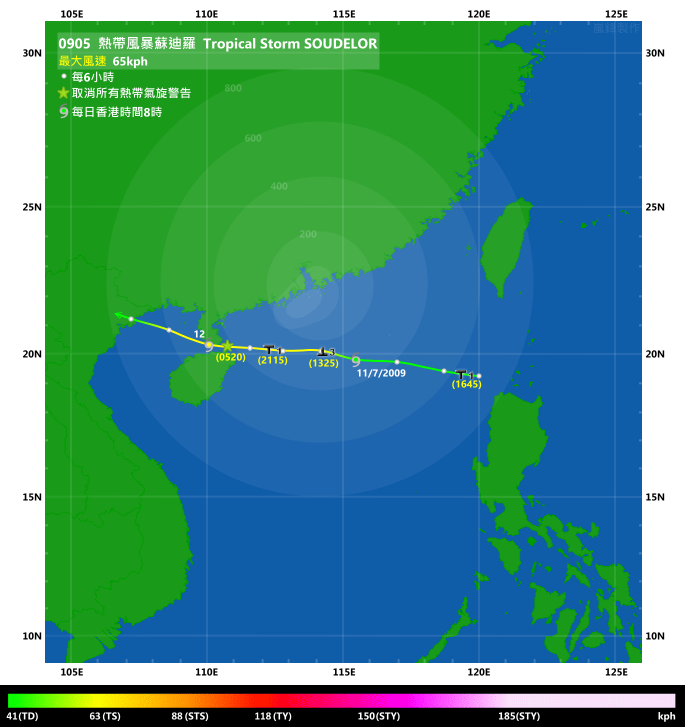
Figure 圖:
(Track courtesy of Lorenzo. Data from HKO. 鳴謝 Lorenzo 提供路徑圖,資料取自天文台)
IR imagery animation 紅外線雲圖動畫:
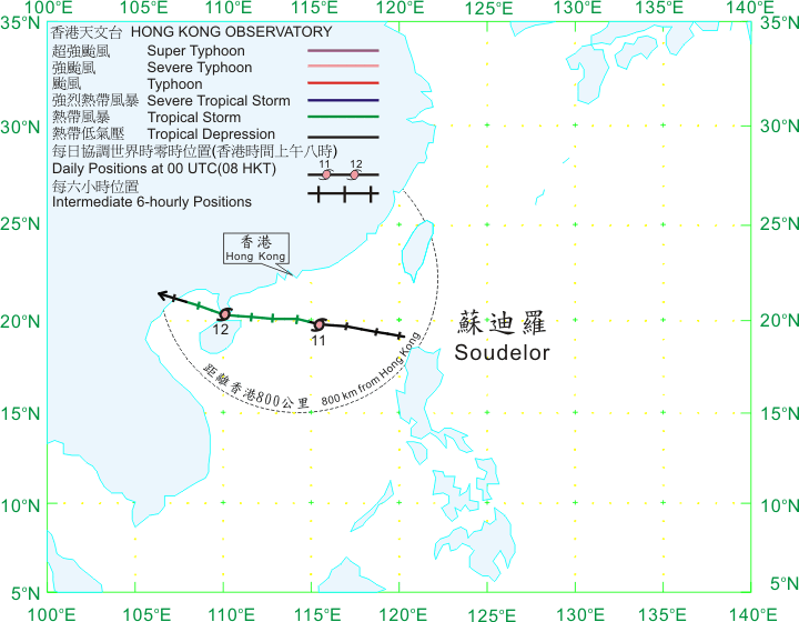
TC track from HKWW 本站的熱帶氣旋路徑圖:
TC track from HKO 天文台的熱帶氣旋路徑圖:
| Past HKWW Bulletins on SOUDELOR 本站有關蘇迪羅的發佈 |
Please click here for bulletins on SOUDELOR. 請按這裡。
| Storm Formation and Signal Issuance 氣旋形成和熱帶氣旋警告信號之發出 |
The intertropical convergence zone (ITCZ) was rather active in early to mid July, spawning three tropical cyclones within 10 days; SOUDELOR was the first of them. An area of disturbance was found to the east of Philippines on July 7th, which moved steadily west-northwestwards towards the Luzon Strait. As its structure improved, the JTWC upgraded this disturbance (99W) into the fifth tropical depression (05W) of the year at 02 HKT on July 10th, and predicted a pretty close CPA (closest point of approach) to Hong Kong which did not realize due to the strong subtropical ridge.
The HKO upgraded 05W into tropical depression status 12 hours later as it moved further into the northern South China Sea. When the upgrade was made the cyclone was already within 800 km of Hong Kong. To warn the public about 05W, the Observatory promptly issued the #1 Standby Signal at 16:45 HKT when it was 670 km ESE of Hong Kong. Subsidence of the cyclone brought very hot and hazy weather to Hong Kong, and the very hot weather warning was in force for more than 32 hours from July 9th to July 10th.
熱帶輻合帶於七月上半部頗為活躍,於 10 日內製造出三個熱帶氣旋,蘇迪羅為三者中的第一個。熱帶擾動 99w 於 7 月 7 日於菲律賓以東形成,並穩定向西北偏西移動,靠近呂宋海峽。隨著它的結構變好,JTWC 於 10 日上午 2 時將其升格為熱帶低氣壓 05W,並預計該熱帶氣旋將會頗為接近香港 (但由於當時副熱帶高壓脊較為強勁,此預測並未能實現)。
香港天文台於 12 小時後對其作出升格,當時 05W 已經進入南海並於本港 800 公里內。為提醒市民有一熱帶氣旋可能會於稍後影響香港,天文台於當天 (10 日) 下午 4 時 45 分發出一號戒備信號;當時 05W 於香港東南偏東約 670 公里。與其相關的下沉氣流為本港帶來酷熱和有煙霞的天氣,而酷熱天氣警告亦於 9 至 10 日連續 32 小時生效。
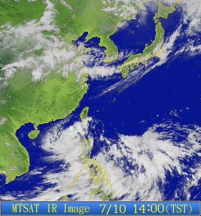
Figure 1 - IR imagery of 05W at 14 HKT on July 10th, the time that HKO upgraded the system into a tropical depression
圖 1 - 7 月 10 日下午 2 時的紅外線衛星雲圖;香港天文台於當時升格該系統為熱帶低氣壓

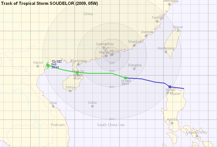
Figure 2 - Initlal track forecast from the JTWC
圖 2 - JTWC 第一佈
| Storm Development 氣旋發展 |
Wind shear gradually heightened in the South China Sea, and 05W failed to gain strength significantly. Convections were limited to the western and southern quadrants, which explained the lack of precipitation along central Guangdong coast including Hong Kong. Steering at the appropriate level indicated a W to WNW movement at that time.
05W accelerated to the west, and as it moved closer to the territory, the Observatory issued the #3 Strong Wind Signal at 13:25 HKT on July 11th. Both the JMA and the HKO upgraded 05W into tropical storm status at 14 HKT, with the JMA naming it SOUDELOR. The name was contributed by Micronesia; SOUDELOR was the name of a legendary Pohnpei chief. At this time, occasional strong winds were recorded at stations unobscured to the east like Waglan Island and Cheung Chau. The Hong Kong Observatory also shifted its forecast track to a rather flat westward journey for the next 24 hours, which showed remarkable accuracy compared with the real storm track later observed.
SOUDELOR then failed to gain any strength, as convections once bursted were displaced to the western quadrant. The storm made its closest point of approach just shortly after the Strong Wind Signal was issued, at a distance of about 250 km from the Observatory. Just after a little less than 8 hours of issuance, the #3 Strong Wind Signal was replaced by the #1 Standby Signal as winds began to weaken in Hong Kong, yet occasional strong winds were still observed at offshore stations and on high grounds.
南海的垂直風切變逐漸增強,令 05W 未能明顯地增強。它的對流被切離至低層環流中心的西面和南面,因此未能於經過南海北部期間為廣東中部沿岸帶來可觀的降雨。與此同時,從駛流圖可以看到 05W 將維持向西或西北偏西的移動路徑。
05W 向西加速移動。由於它繼續接近香港,天文台於 11 日下午 1 時 25 分發出三號強風信號。隨後,日本氣象廳和香港天文台均於下午 2 時把 05W 升格為熱帶風暴,前者把它命名為蘇迪羅。蘇迪羅一名由米克羅尼西亞提供,為波納佩島 (Pohnpei) 傳說中的將領。這時,部分東面沒有阻礙的氣象站開始間中錄得強風,如橫欄島和長洲。天文台同時把蘇迪羅未來 24 小時的預測路徑調整至偏西方向,結果與實際路徑非常吻合。
升格為熱帶風暴後,蘇迪羅仍然受到強垂直風切變影響,對流一爆發出來就切離至其西面,致使它不能增強。蘇迪羅於發出三號信號不久便最為接近香港,大約於香港以南 250 公里處。發出三號信號少於 8 小時後,由於本港風勢普遍減弱,天文台於當天晚上 9 時 15 分改發一號戒備信號;改發後離岸和高地仍間中吹強風。
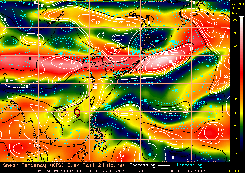
Figure 3 - Wind shear chart, July 11th 14 HKT
圖 3 - 7 月 11 日下午 2 時的垂直風切變分布圖

Figure 4 - Visible imagery of SOUDELOR at 14:30 HKT on July 11th
圖 4 - 7 月 11 日下午 2 時 30 分的可見光衛星雲圖
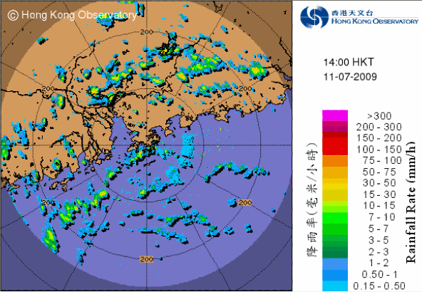
Figure 5 - RADAR image at 14 HKT, July 11th. SOUDELOR was about 240 km south of Hong Kong at that time.
圖 5 - 7 月 11 日下午 2 時的雷達圖;當時蘇迪羅約在香港以南 240 公里


Figures 6a to 6d - Wind directions across Hong Kong at 10, 14, 18, 22 HKT on July 11th
圖 6a 至 6d - 7 月 11 日 10、14、18 和 22 時的香港風速和風向分布圖

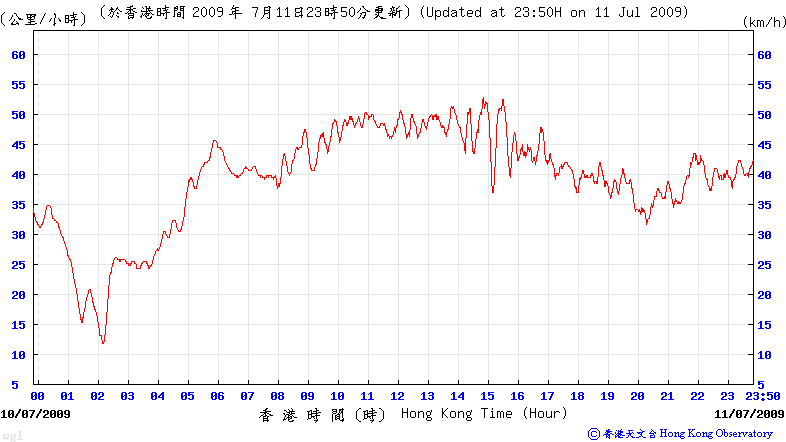
Figures 7a (above) and 7b (below) - Wind speeds on July 11th at Cheung Chau and Waglan Island respectively
圖 7a (上) 和 7b (下) - 7 月 11 日 於長洲和橫欄島的風速
| SOUDELOR's Landfalls 蘇迪羅的登陸 |
Winds gradually turned in a clockwise direction to the southeast in the latter part of July 11th. As winds continued to subside the Observatory cancelled the #1 Standby Signal at 05:20 HKT on July 12th. Part of the storm brieftly landed at the northern tip of Hainan Island and a part at the southern tip of Leizhou Peninsula, and in effect it never left far away from water as it passed through the Qiongzhou Strait.
本港風向於 11 日後期逐漸以順時針方向轉向東南,隨著蘇迪羅遠離,本港風力繼續下跌,天文台於翌日 (12 日) 上午 5 時 20 分取消一號信號。蘇迪羅短暫於海南島北部擦過,亦於雷洲半島南端稍作登陸;基本上蘇迪羅於瓊州海峽通過時並未跟陸地有太多接觸。
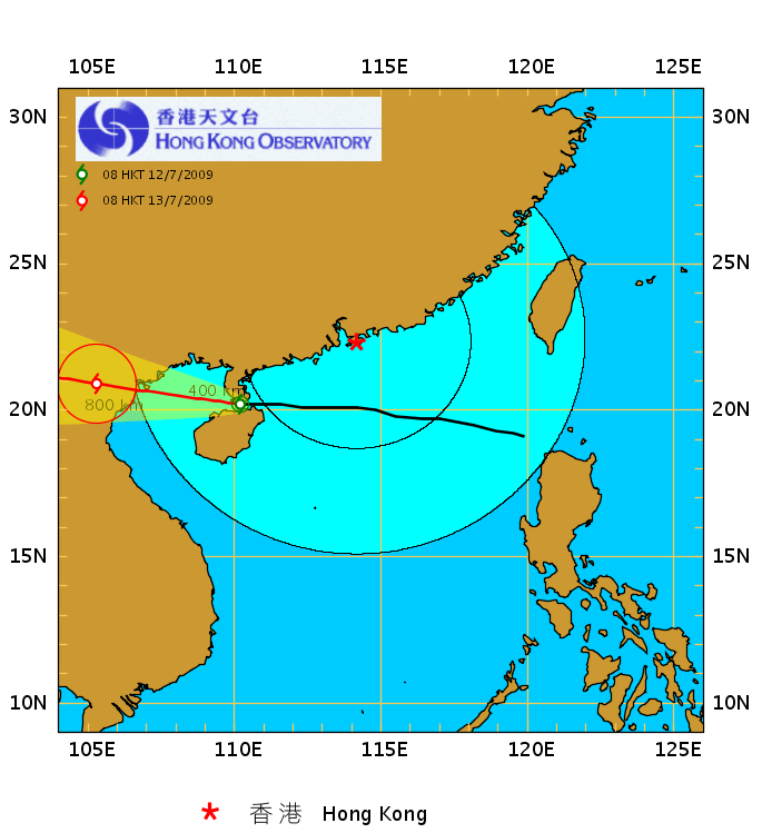
Figure 8 - SOUDELOR tracking across the Qiongzhou Strait
圖 8 - 蘇迪羅橫過瓊州海峽
The final hours of SOUDELOR's marine journey, which was spent in the Gulf of Tonkin, was largely uneventful. The storm made its second landfall near Hon Gai (Ha Long) in Vietnam at about 20 HKT the same day (July 12th) as a minimal tropical storm, and brought heavy rains to the region. Due to the lack of water vapour, SOUDELOR weakened rapidly and was downgraded into an area of low pressure by the HKO in its bulletin at 01:55 HKT the next day.
蘇迪羅隨後經過北部灣,於大約 8 時在越南下龍 (鴻基) 附近以熱帶風暴強度登陸,為當地帶來大雨。由於缺乏水氣供應,蘇迪羅於登陸後迅速減弱,天文台亦於 13 日上午 1 時 55 分的發佈中把它降格為低壓區。
| Winds Recorded at Reference Stations 參考站所錄得的風速 |
| Station 風速站 |
Max. 10-min avg. wind speed 最高十分鐘平均風速 |
Beaufort classification 蒲福氏風級分類 |
| Chek Lap Kok 赤鱲角 | 40 km/h | Fresh 清勁 |
| Cheung Chau 長洲 | 54 km/h | STRONG 強風 |
| Kai Tak 啟德 | 37 km/h | Fresh 清勁 |
| Sai Kung 西貢 | 42 km/h | STRONG 強風 |
| Sha Tin 沙田 | 25 km/h | Moderate 和緩 |
| Ta Kwu Ling 打鼓嶺 | 23 km/h | Moderate 和緩 |
| Tsing Yi (SHL) 青衣蜆殼油庫 | 22 km/h | Moderate 和緩 |
| Wetland Park 濕地公園 | 28 km/h | Moderate 和緩 |
| Number of stations recording at least STRONG force (force 6 - 7) winds: | 2 |
Number of stations recording at least GALE force (force 8 - 9) winds: |
0 |
| Number of stations recording at least STORM force (force 10 - 11) winds: | 0 |
| Number of stations recording HURRICANE force (force 12) winds: | 0 |
| 錄得 強風 (6 - 7 級) 或更高風速的站數: | 2 |
| 錄得 烈風 (8 - 9 級) 或更高風速的站數: | 0 |
| 錄得 暴風 (10 - 11 級) 或更高風速的站數: | 0 |
| 錄得 颶風 (12 級) 風速的站數: | 0 |
| Charts and Figures 各項數據 |
Table 1: Track data from HKWW:
表一 : 香港天氣觀測站之路徑資料
YYMMDDZZ Lat Long Wind |
Table 2: Maximum gust and 60-minute average wind speed recorded in Hong Kong from HKO:
表二 : 香港天文台公佈的各站最高 60 分鐘平均風力和陣風數據
Maximum Gust |
Maximum Hourly Wind |
|||||||
| Station | Direction |
Speed(km/h) |
Date/Month |
Time |
Direction |
Speed(km/h) |
Date/Month |
Time |
| Bluff Head(Stanley) | ENE |
72 |
11/7 |
13:21 |
E |
40 |
11/7 |
18:00 |
| Central Pier | E |
58 |
11/7 |
13:40 |
E |
38 |
11/7 |
14:00 |
| Cheung Chau | SE |
79 |
11/7 |
16:03 |
ESE |
43 |
12/7 |
03:00 |
| Cheung Sha Wan | NE |
54 |
11/7 |
09:02 |
ENE |
19 |
11/7 |
10:00 |
| Hong Kong International Airport | E |
62 |
11/7 |
16:18 |
E |
34 |
11/7 |
13:00 |
| Kai Tak | E |
76 |
11/7 |
11:19 |
E |
34 |
11/7 |
13:00 |
| King's Park | E |
63 |
11/7 |
12:25 |
E |
27 |
11/7 |
14:00 |
| Lau Fau Shan | E |
62 |
11/7 |
15:58 |
E |
34 |
11/7 |
16:00 |
| Ngong Ping | E |
96 |
11/7 |
18:12 |
E |
75 |
11/7 |
18:00 |
| North Point | E |
67 |
11/7 |
14:55 |
E |
31 |
11/7 |
13:00 |
| Peng Chau | ENE |
67 |
11/7 |
12:51 |
ENE |
45 |
11/7 |
14:00 |
| Ping Chau | E |
52 |
11/7 |
13:44 |
E |
16 |
11/7 |
14:00 |
| Sai Kung | NE |
58 |
11/7 |
12:02 |
ENE |
40 |
11/7 |
15:00 |
ENE |
58 |
11/7 |
14:38 |
|||||
ENE |
58 |
11/7 |
14:39 |
|||||
| Sha Chau | SSE |
52 |
11/7 |
14:42 |
E |
36 |
11/7 |
14:00 |
| Sha Lo Wan | E |
54 |
11/7 |
14:02 |
E |
31 |
11/7 |
14:00 |
E |
54 |
12/7 |
02:32 |
|||||
| Sha Tin | NNE |
47 |
11/7 |
14:14 |
ENE |
19 |
11/7 |
16:00 |
| Shek Kong | E |
56 |
11/7 |
11:07 |
E |
30 |
11/7 |
01:00 |
| Star Ferry (Kowloon) | E |
51 |
11/7 |
22:44 |
E |
30 |
11/7 |
18:00 |
E |
30 |
11/7 |
23:00 |
|||||
| Ta Kwu Ling | ENE |
45 |
11/7 |
11:03 |
ENE |
20 |
11/7 |
15:00 |
| Tai Mei Tuk | SE |
70 |
11/7 |
16:04 |
E |
51 |
11/7 |
15:00 |
| Tai Mo Shan | ESE |
90 |
11/7 |
17:10 |
E |
59 |
11/7 |
18:00 |
| Tap Mun | SE |
59 |
11/7 |
15:58 |
ESE |
25 |
11/7 |
18:00 |
| Tate's Cairn | E |
81 |
11/7 |
10:34 |
E |
52 |
11/7 |
11:00 |
| Tsak Yue Wu | ENE |
43 |
11/7 |
14:52 |
ENE |
16 |
11/7 |
15:00 |
| Tseung Kwan O | E |
54 |
11/7 |
15:01 |
E |
16 |
11/7 |
13:00 |
| Tsing Yi Shell Oil Depot | SE |
47 |
12/7 |
04:08 |
E |
19 |
11/7 |
15:00 |
| Tuen Mun Government Offices | SE |
51 |
11/7 |
16:32 |
ESE |
20 |
11/7 |
01:00 |
| Waglan Island | E |
72 |
11/7 |
14:15 |
NE |
49 |
11/7 |
11:00 |
ENE |
49 |
11/7 |
14:00 |
|||||
| Wetland Park | E |
52 |
11/7 |
15:41 |
E |
25 |
11/7 |
16:00 |
| Wong Chuk Hang | E |
58 |
11/7 |
13:05 |
E |
30 |
11/7 |
14:00 |
Table 3: Rainfall contributed by MOLAVE from HKO (figures in brackets are based on incomplete hourly data):
表三 : 香港天文台公佈的各站雨量資料 (方括號內之數據由不完整之每小時資料擷取)
| Station | 10 July |
11 July |
12 July |
Total |
|
| Hong Kong Observatory | Trace |
8.1 |
Trace |
8.1 |
|
| Cheung Chau (CCH) | 0.0 |
11.5 |
0.0 |
11.5 |
|
| Hong Kong International Airport (HKA) | 0.0 |
8.5 |
0.0 |
8.5 |
|
| N05 | Fanling | 0.0 |
6.0 |
0.5 |
6.5 |
| N13 | High Island | 0.0 |
0.5 |
0.5 |
1.0 |
| K04 | Jordan Valley | 0.0 |
2.5 |
0.0 |
2.5 |
| N06 | Kwai Chung | 0.0 |
3.5 |
0.0 |
3.5 |
| H12 | Mid Levels | 1.0 |
34.0 |
0.0 |
35.0 |
| H21 | Repulse Bay | 0.0 |
11.0 |
0.0 |
11.0 |
| N09 | Sha Tin | [0.0] |
[2.5] |
[0.0] |
[2.5] |
| H19 | Shau Kei Wan | 0.0 |
23.0 |
0.0 |
23.0 |
| SEK | Shek Kong | 0.0 |
2.5 |
1.5 |
4.0 |
| K06 | So Uk Estate | 0.0 |
[2.0] |
0.0 |
[2.0] |
| PLC | Tai Mei Tuk | [0.5] |
[5.0] |
0.0 |
[5.5] |
| R21 | Tap Shek Kok | 0.0 |
1.0 |
0.0 |
1.0 |
| N17 | Tung Chung | 0.0 |
14.5 |
0.0 |
14.5 |
| R27 | Yuen Long | 0.0 |
0.0 |
0.0 |
0.0 |
Last Accessed 最近訪問日期: Sun Sep 08 2024 12:39:21 HKT
Last Modified 最近修訂日期: Mon Jul 24 2023
