
TC Watch / 熱帶氣旋 > Selected TC Review / 重要熱帶氣旋回顧 > 200903W (LINFA 蓮花) [Refresh 更新]
 200903W (LINFA 蓮花) - Profile 檔案 200903W (LINFA 蓮花) - Profile 檔案 |
(First draft issued on July 3rd, 2009; final version issued on July 8th, 2009)
(中文版於 2009 年 7 月 31 日發出)
Brief profile of LINFA 蓮花小檔案:
| JTWC number 聯合颱風警報中心 (JTWC) 號碼 | 03W |
| International number 國際編號 | 0903 |
| Period of existence 生存時期 | 17 June, 2009 14 HKT to 22 June, 2009 20 HKT |
| Lifetime 壽命 | 5.25 days 日 |
| Maximum 1-minute wind (JTWC) JTWC 一分鐘平均最高中心風速 | 75 knots 節 (Category 1 Typhoon 一級颱風) |
| Minimum pressure (JTWC) JTWC 最低氣壓 | 967 hPa 百帕 |
| Highest TC signal by HKO (if applicable) 香港天文台發出最高熱帶氣旋警告信號 |
1 (Standby Signal 戒備信號) |
| Closest point of approach by HKO (if applicable) 香港天文台所示之最接近距離 (如適用) |
ESE 360 km (real-time warning 實時報告) / ESE 380 km (TC report 熱帶氣旋報告) |
| Time of closest approach by HKO (if applicable) 香港天文台所示之最接近時間 (如適用) |
20 June, 2009 13 & 15 HKT (real-time warning: [1], [2]) / 14 HKT (TC report) |
| Lowest pressure recorded at HKO (if applicable) 香港天文台錄得的最低氣壓 (如適用) |
999.7 hPa 百帕 (20 June, 2009 17:08 to 17:14 HKT) |
TC signals for Hong Kong & Track 香港曾經生效的熱帶氣旋警告和路徑圖:
Table 表:
| Signal 信號 |
Date and time 日期和時間 |
Distance from HK 與香港的距離 |
Predicted movement 預測移動方向和速度 |
Max. 10-min winds 中心最高十分鐘平均風速 |
 |
2009/06/20 (SAT) 10:40 HKT |
SE 370 km |
N at 10 km/h |
103 km/h (55 knots, STS) |
 |
2009/06/21 (SUN) 05:45 HKT |
E 420 km |
NNE at 18 km/h |
112 km/h (60 knots, STS) |
Figure 圖:
(Track courtesy of Lorenzo. Data from HKO. 鳴謝 Lorenzo 提供路徑圖,資料取自天文台)
IR imagery animation 紅外線雲圖動畫:
TC track from HKWW 本站的熱帶氣旋路徑圖:

TC track from HKO 天文台的熱帶氣旋路徑圖:

| Past HKWW Bulletins on LINFA 本站有關蓮花的發佈 |
Please click here for bulletins on LINFA. 請按這裡。
| Storm Formation and Development 氣旋形成和發展 |
Tropical disturbance 98W formed east of the Philippines in the middle of June, 2009. It attempted to organize itself but was unsuccessful (the JTWC issued a Tropical Cyclone Formation Alert (TCFA) for this disturbance but was cancelled later), and it crossed Luzon after a few days. A lack of steering flow rendered 98W motionless in the eastern part of the South China Sea and this allowed time for its intensification.
As 98W's organization continued to improve, the JTWC upgraded it into the third numbered tropical depression of the year in the afternoon of June 17th. The HKO followed suit and also upgraded it at 20 HKT that day. As the steering ridge was east of the system and southwest monsoon was prevailing at that moment, initial forecasts called for a NNE to NE movement towards the southeastern coast of China (the JTWC, on the other hand, predicted a stronger eastward component and drove the storm towards Luzon Strait).
The depression consolidated in the next 24 hours, and the JMA designated the system tropical storm LINFA at 14 HKT on June 18th, skipping the tropical cyclone "gale warning" that would indicate the formation of a tropical storm soon. The name LINFA was contributed by Macao and means "Lotus" in English.
熱帶擾動 98W 於 6 月中旬於菲律賓以東海域形成,它多次嘗試整固但都不成功 (JTWC 曾對其發出熱帶氣旋形成警報,但稍後被取消)。數日後它橫過呂宋,其後由於缺乏淨駛流力量而於南海停留不動,有利它逐漸增強。
隨著 98W 增強,JTWC 於 6 月 17 日將其升格為熱帶低氣壓 03W,天文台則於下午 8 時跟隨。由於副熱帶高壓脊在其東面,而西南季候風正於南海活躍,初期預測預計 03W 將向東北至東北偏北移動,趨向中國東南沿岸 (JTWC 則預計 03W 將向東北移向呂宋海峽)。
該熱帶低氣壓於其後 24 小時整固,日本氣象廳在沒有發出熱帶風暴形成警告下於 18 日下午 2 時把其升格為熱帶風暴,並給予名稱 "蓮花"。蓮花一名由澳門提供。

Figure 1 - Initial track by the JTWC. Notice that prior to formation 98W had travelled a long distance.
圖 1 - JTWC 的首份發佈。留意在形成前該系統已移動了一段頗長的距離
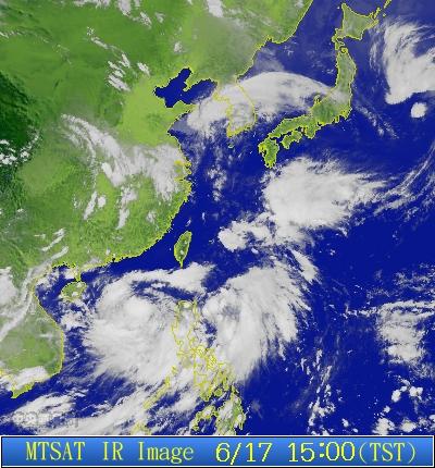
Figure 2 - 03W formed in the South China Sea
圖 2 - 03W 於南海形成

Figure 3 - Steering chart at 14 HKT on June 17th
圖 3 - 6 月 17 日下午 2 時的駛流圖
| Effects to Hong Kong 對香港的影響 |
Although LINFA was formed within 800 kilometres from Hong Kong, it moved very slowly and the predicted track posed little threat to Hong Kong. The Observatory, probably because of this reason, did not issue the Standby Signal right away at its formation. Affected by another disturbance east of Luzon Strait, LINFA exhibited erratic movement to the southeast during June 18th and it was not until it had travelled some 100 kilometres eastward before it finally turned to a northerly track, responding to the ridge's orientation.
In the course of LINFA's initial erratic movement, most agencies changed their track forecast to align with the JTWC's initial forecast (i.e. to put the storm towards the Luzon Strait). However as LINFA travelled progressively northwards later on June 19th, they amended their forecasts to put the storm into Taiwan Strait or even a landfall in southeastern China.
Due to good sea surface temperatures and outflow channels, LINFA continued to intensify. The storm also exhibited some NNW movement during the night of June 19th. The Observatory upgraded LINFA into a severe tropical storm in its 01 HKT bulletin on June 20th. As the storm enters the 400 km circle, the Observatory finally issued the #1 Standby Signal at 10:40 HKT on the same day, indicating that swells might be present in offshore waters.
Due to the subsidence of LINFA, Hong Kong experienced hot weather with light winds during the weekend of June 20th. However as LINFA was nowhere close to Hong Kong, those were the only effects attributed to the storm.
雖然蓮花於本港 800 公里內形成,但它初期移動非常緩慢,而預測路徑亦對香港無甚影響,可能因為這些原因令天文台不即時發出熱帶氣旋警告信號。受到呂宋以東的另一個擾動影響,蓮花於 18 日的移動方向並不穩定;只當它向東移 100 公里後才採取一個持續向北的路徑,對應當時的駛流狀況。
於蓮花移動緩慢且方向不定之時,大部分官方預測開始偏向 JTWC 第一佈所作的預期路徑,即偏向認為蓮花會移向呂宋海峽或台灣南部。但由於蓮花於 19 天開始向偏北移動,它們都改為預測蓮花於台灣海峽經過或於中國東南部登陸。
受惠於良好的輻散和偏高的水溫,蓮花繼續增強;它亦於 19 日晚稍為向西北偏北移。天文台於 20 日上午 1 時升格蓮花為強烈熱帶風暴。隨著蓮花進入香港 400 公里範圍,天文台於同日上午 10 時 40 分發出一號戒備信號,並表示離岸海域可能有湧浪。
蓮花的外圍下沉氣流令香港該週末的天氣變得酷熱且有煙霞,但由於蓮花沒有繼續靠近香港,它對本地的影響僅此而已。


Figures 4a and 4b - Forecast by various agencies, June 19th at 14 HKT (left) and June 20th at 14 HKT (right). Note the short-term NNW movement in the night of June 19th.
圖 4a 及 4b - 各台預測路徑圖。留意蓮花於 19 日晚曾向西北偏北移動

Figure 5 - LINFA at 14 HKT on June 20th. By that time the JTWC has upgraded it into a typhoon (65 knots), while other "10-minute average" agencies were keeping it as a severe tropical storm.
圖 5 - 蓮花於 6 月 20 日下午 2 時的形態。JTWC 當時把它定為颱風 (65 節),而多數以 10 分鐘平均風速為準的氣象台則把它定為強烈熱帶風暴

Figure 6 - Steering chart at 14 HKT on June 20th
圖 6 - 6 月 20 日下午 2 時的駛流圖
| Approaching Coastal Areas and Its Subsequent Weakening 趨向中國東南部沿岸地區並於登陸後減弱 |
As if the Mother Nature were playing a game with the Observatory, LINFA almost immediately moved away from Hong Kong after the issuance of the Standby Signal on June 20th. The closest point of approach was 360 kilometres (while at the time of signal issuance the distance was 370 kilometres), recorded twice at 13 and 15 HKT on that day. The storm soon moved away from the 400 km circle in the night between June 20th and 21st, moving NE to NNE in the interim.
天意弄人,當天文台發出一號戒備信號後不久,蓮花即開始遠離香港。蓮花於 20 日下午 1 時和 3 時距離香港最近,為約 360 公里,和發出信號時的 370 公里差不多。在 20 日晚上和 21 日凌晨之間,蓮花移離本港 400 公里範圍,期間向東北至東北偏北移動。

Figure 7 - HKO's forecast for LINFA, 17 HKT on June 20th
圖 7 - 6 月 20 日下午 5 時由天文台發出的預測路徑圖
As the storm moved north, it reached the latitude of Hong Kong (22.3°N) in the morning on June 21st. Seeing a declined threat to the territory, the Observatory lifted all signals at 05:45 HKT the same day. However the storm did not moved quickly away from Hong Kong, as it reverted to its usual northward track for the rest of the day.
Storm strength peaked on June 20th while the Standby Signal was still in effect. It briefly developed a banding eye that was visible in IR imagery near 20 HKT on June 20th, but disappeared soon as it encountered higher vertical wind shear and was approaching land. The JTWC remained the only agency (as they were using a 1-minute standard for sustained wind speeds) that upgraded LINFA into a typhoon, and the maximum wind speed was reported as 75 knots.
隨著蓮花北移並於 21 日早上到達香港的緯度 (北緯 22.3 度),天文台於同日上午 5 時 45 分取消所有熱帶氣旋警告信號。但由於蓮花隨即向偏北移動,實際上它並沒有快速移離香港。
蓮花於 20 日一號信號生效時到達巔峰強度,並短暫出現一雲捲風眼,於該晚 8 時在紅外線衛星雲圖上可見。但受到稍高垂直風切變和靠近陸地的影響,風眼很快便消失。使用一分鐘平均風速的 JTWC 為唯一官方機構把蓮花定為颱風,風速為 75 節。

Figure 8 - LINFA at peak strength (75 knots by the JTWC), 20:57 HKT on June 20th
圖 8 - 蓮花近巔峰時狀態 (75 節,於 6 月 20 日下午 8 時 57 分)
LINFA made landfall east of Xiamen in the night of June 21st, bringing violent winds and heavy rain to the region. The storm subsequently turned to a northeasterly direction and skirted the coast of southeastern China during June 22nd. As friction increased and sea surface temperatures continued to drop due to higher latitudes, LINFA weakened gradually and finally it was downgraded into an area of low pressure by the HKO after reaching 30°N, at 16:15 HKT on June 23rd.
蓮花於 21 日晚在廈門以東登陸,為當地帶來強風和大雨。其後蓮花向東北移動,於 22 日擦過中國東南部沿海地區。由於摩擦力增加而海水溫度不斷下降,蓮花迅速減弱,最後於 23 日下午 4 時 15 分被香港天文台降格為一低壓區。

Figure 9 - LINFA close to landfall near XIamen, 14:30 HKT on June 21st
圖 9 - 蓮花即將登陸廈門附近 (6 月 21 日下午 2 時 30 分)
| Winds Recorded at Reference Stations 參考站所錄得的風速 |
(Except for special cases, this section is not available for cyclones that only necessitated the Standby Signal 除非特別情況,否則此部只當氣旋令天文台發出三號或更高信號時提供)
| Charts and Figures 各項數據 |
Table 1: Track data from HKWW:
表一 : 香港天氣觀測站之路徑資料
YYMMDDZZ Lat Long Wind |
Table 2: Maximum gust and 60-minute average wind speed recorded in Hong Kong from HKO:
表二 : 香港天文台公佈的各站最高 60 分鐘平均風力和陣風數據
Maximum Gust |
Maximum Hourly Wind |
|||||||
Station |
Direction |
Speed (km/h) |
Date/Month |
Time |
Direction |
Speed (km/h) |
Date/Month |
Time |
Bluff Head (Stanley) |
W |
38 |
21/6 |
05:29 |
W |
16 |
21/6 |
05:00 |
Central Pier |
WNW |
36 |
20/6 |
13:35 |
W |
14 |
20/6 |
14:00 |
Cheung Chau |
SE |
31 |
21/6 |
05:25 |
WSW |
19 |
20/6 |
17:00 |
SE |
31 |
21/6 |
05:30 |
|
|
|
|
|
SE |
31 |
21/6 |
05:35 |
|
|
|
|
|
Hong Kong International Airport |
SW |
30 |
21/6 |
03:57 |
SW |
19 |
21/6 |
05:00 |
SW |
30 |
21/6 |
04:32 |
|
|
|
|
|
Kai Tak |
WNW |
27 |
21/6 |
05:41 |
SW |
12 |
20/6 |
15:00 |
King's Park |
W |
40 |
21/6 |
05:09 |
W |
13 |
20/6 |
16:00 |
Lau Fau Shan |
WSW |
31 |
20/6 |
16:24 |
WSW |
23 |
20/6 |
17:00 |
Ngong Ping |
W |
51 |
21/6 |
04:49 |
W |
31 |
21/6 |
05:00 |
North Point |
WSW |
31 |
21/6 |
05:41 |
W |
13 |
20/6 |
15:00 |
Peng Chau |
WSW |
27 |
21/6 |
05:41 |
SW |
7 |
20/6 |
15:00 |
Ping Chau |
S |
22 |
20/6 |
15:48 |
SW |
9 |
20/6 |
14:00 |
Sai Kung |
WSW |
25 |
21/6 |
05:45 |
S |
16 |
20/6 |
15:00 |
Sha Chau |
SSW |
27 |
20/6 |
21:07 |
SSW |
20 |
20/6 |
21:00 |
Sha Lo Wan |
SW |
27 |
21/6 |
04:36 |
SW |
13 |
21/6 |
05:00 |
Sha Tin |
SSW |
27 |
21/6 |
05:44 |
SSW |
14 |
20/6 |
16:00 |
Shek Kong |
WNW |
20 |
20/6 |
14:03 |
NW |
7 |
20/6 |
15:00 |
Star Ferry (Kowloon) |
WNW |
31 |
21/6 |
05:30 |
WNW |
16 |
20/6 |
14:00 |
WNW |
31 |
21/6 |
05:31 |
|
|
|
|
|
Ta Kwu Ling |
WSW |
22 |
20/6 |
14:18 |
WSW |
9 |
20/6 |
15:00 |
Tai Mei Tuk |
W |
31 |
20/6 |
16:47 |
S |
13 |
20/6 |
17:00 |
Tai Mo Shan |
W |
31 |
20/6 |
16:54 |
W |
22 |
20/6 |
17:00 |
Tap Mun |
SE |
20 |
20/6 |
15:07 |
SSW |
9 |
20/6 |
16:00 |
Tate's Cairn |
W |
45 |
21/6 |
05:23 |
SW |
22 |
21/6 |
05:00 |
WSW |
45 |
21/6 |
05:24 |
|
|
|
|
|
Tsak Yue Wu |
SW |
16 |
20/6 |
15:49 |
N |
7 |
20/6 |
11:00 |
|
|
|
|
SW |
7 |
20/6 |
17:00 |
|
Tseung Kwan O |
WNW |
23 |
21/6 |
05:41 |
ENE |
9 |
20/6 |
11:00 |
Tsing Yi Shell Oil Depot |
W |
23 |
21/6 |
05:05 |
S |
9 |
20/6 |
15:00 |
Tuen Mun Government Offices |
W |
27 |
20/6 |
15:24 |
WNW |
12 |
20/6 |
16:00 |
Waglan Island |
WSW |
47 |
21/6 |
05:37 |
SW |
22 |
21/6 |
05:00 |
Wetland Park |
WNW |
25 |
20/6 |
15:51 |
W |
9 |
20/6 |
17:00 |
Wong Chuk Hang |
NW |
23 |
21/6 |
05:05 |
SE |
12 |
20/6 |
14:00 |
Table 3: Rainfall (in millimetres) contributed by LINFA from HKO (figures in brackets are based on incomplete hourly data):
表三 : 香港天文台公佈的各站雨量資料 (方括號內之數據由不完整之每小時資料擷取)
| Station | 20-Jun |
21-Jun |
Total |
|
| Hong Kong Observatory | 0.0 |
0.0 |
0.0 |
|
| Cheung Chau (CCH) | 0.0 |
28.5 |
28.5 |
|
| Hong Kong International Airport (HKA) | 0.0 |
0.6 |
0.6 |
|
| N05 | Fanling | 0.0 |
1.5 |
1.5 |
| N13 | High Island | 1.0 |
0.0 |
1.0 |
| K04 | Jordan Valley | 0.0 |
0.5 |
0.5 |
| N06 | Kwai Chung | 0.0 |
0.0 |
0.0 |
| H12 | Mid Levels | 0.0 |
0.0 |
0.0 |
| H21 | Repulse Bay | 0.0 |
2.0 |
2.0 |
| SHA | Sha Tin | 0.0 |
0.0 |
0.0 |
| H19 | Shau Kei Wan | 0.0 |
0.0 |
0.0 |
| SEK | Shek Kong | 0.0 |
0.0 |
0.0 |
| K06 | So Uk Estate | 0.0 |
0.0 |
0.0 |
| PLC | Tai Mei Tuk | [1.0] |
[0.0] |
[1.0] |
| R21 | Tap Shek Kok | 0.0 |
4.5 |
4.5 |
| N17 | Tung Chung | 0.0 |
36.5 |
36.5 |
| R27 | Yuen Long | 0.0 |
0.0 |
0.0 |
Last Accessed 最近訪問日期: Sun Sep 08 2024 12:41:06 HKT
Last Modified 最近修訂日期: Mon Jul 24 2023
