
TC Watch > Selected TC Review > 200810W (KAMMURI) [Refresh]
 200810W (KAMMURI) - Profile 200810W (KAMMURI) - Profile |
(First issued on August 18th, 2008, final version issued on August 27th, 2008)
Brief profile of KAMMURI:
| JTWC number | 10W |
| International number | 0809 |
| Period of existence | 4 August, 2008 08 HKT to 7 August, 2008 02 HKT |
| Lifetime | 2.75 days |
| Maximum 1-minute wind (JTWC) | 50 knots |
| Minimum pressure (JTWC) | 985 hPa |
| Highest TC signal by HKO (if applicable) | 8 (Gale or Storm Signal, directions: NE and SE in order) |
| Closest point of approach by HKO (if applicable) | SSW 130 km (real-time warning and TC report) |
| Time of closest approach by HKO (if applicable) | 6 August, 2008 11-12 HKT (real-time warning) / 6 August, 2008 10 HKT (TC report) |
| Lowest pressure recorded at HKO (if applicable) | 990.6 hPa (6 August, 2008 6:51-6:52 HKT) |
TC signals for Hong Kong & Track:
Table:
Signal |
Date and time |
Distance from HK |
Predicted movement |
Max. 10-min winds |
 |
2008/08/04 (MON) 10:15 HKT |
SE 610 km |
W/WNW at 10 km/h |
47 km/h (25 knots, TD) |
 |
2008/08/05 (TUE) 19:15 HKT |
SSE 220 km |
NW at 16 km/h |
75 km/h (40 knots, TS) |
 |
2008/08/06 (WED) 05:40 HKT |
S 170 km |
WNW at 14 km/h |
103 km/h (55 knots, STS) |
 |
2008/08/06 (WED) 08:40 HKT |
S 150 km |
WNW at 14 km/h |
112 km/h (60 knots, STS) |
|
2008/08/06 (WED) 17:15 HKT |
WSW 210 km |
WNW at 20 km/h |
103 km/h (55 knots, STS) |
|
2008/08/07 (THU) 04:15 HKT |
W 420 km |
W at 18 km/h |
75 km/h (40 knots, TS) |
 |
2008/08/07 (THU) 07:15 HKT |
WSW 490 km |
W at 18 km/h |
75 km/h (40 knots, TS) |
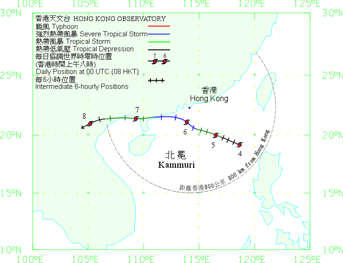
Figure: (Track courtesy of Lorenzo. Data from HKO.)

IR imagery animation 紅外線雲圖動畫:
TC track from HKWW:

TC tracks from HKO:
| Past HKWW Bulletins on KAMMURI |
Please click here for bulletins on KAMMURI.
| Storm Formation in the South China Sea |
Two disturbances developed in the NW Pacific on the first few days in August 2008 - one in the South China Sea (99W) and the other just near the tip of the Philippines (90W) (figure 1a). On early August 4th, 90W moved off the Philippines into the South China Sea and due to decreased land interaction, it developed into a tropical depression (figure 1b). The HKO was among the first agencies to upgrade 90W into tropical depression status, and the Standby Signal Number 1 was issued at the time of formation.
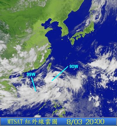
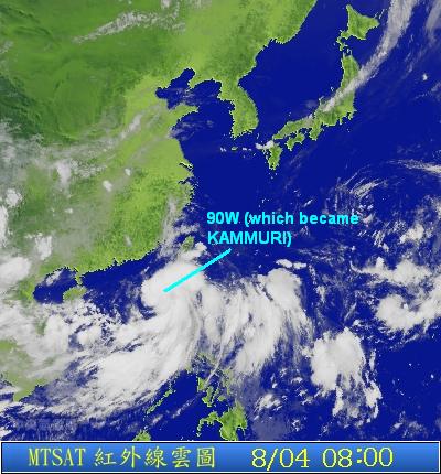
Figures 1a and 1b: IR imagery of 90W and 99W at the times specified


Figures 2 and 3: First TC track issued by the HKO and JTWC respectively
| Storm Movement across the South China Sea and Tropical Cyclone Signals in Hong Kong |
Influenced by the anticyclone NE of the storm, it tracked WNW generally in the northern part of the South China Sea (figure 4). It intensified into a tropical storm at 08 HKT on August 5th and was duly named KAMMURI by the JMA. At that time KAMMURI was about 340 km SE of Hong Kong, and the HKO mentioned that the Strong Wind Signal Number 3 may be necessary that evening.
The active SW monsoon provided the necessary moisture to KAMMURI, and strong cloud bands developed rapidly in the southern part of the storm on August 5th. However, the northern bands were particularly weak and a cloud-free region could be seen in the northeastern quadrant.

Figure 4 - Steering chart at 14 HKT, August 5th
As KAMMURI begins to edge closer to the Guangdong coast, the HKO issued the Strong Wind SIgnal Number 3 at 19:15 HKT the same day when the storm was 220 km SSE of Hong Kong. At that time, KAMMURI was in the middle of tropical storm strength (maximum 10-minute sustained wind speed of 75 km/h). In an interview later that night, Acting Assistant Director Mr Leung Wing-mo of the HKO mentioned that for a number 8 signal to be issued for a tropical storm, its distance must be very close to Hong Kong (i.e. a "direct hit"). Nevertheless, the HKO tropical cyclone bulletin still kept the words "The chance of issuing the Gale or Storm Signal Number 8 cannot be ruled out" as the storm may intensify further beyond tropical storm strength (it was already a strong tropical storm [about 80 km/h] at that time according to the HKO).
KAMMURI's convection tightened after midnight of August 6th. As KAMMURI continued to strengthen, the HKO upgraded it into a severe tropical storm at 03:45 HKT and issued the pre-no. 8 special announcement at the same time, indicating a higher signal at or before 05:45 HKT.
Winds picked up significantly in the early hours of August 6th, with storm force winds blowing at Waglan Island and generally strong winds in other parts of the territory. The HKO issued the Number 8 Northeast Gale or Storm Signal [links: 1 2] at 05:40 HKT and later indicated that the signal would be in force for most of the daytime. Classes of all day schools and most economic activities were suspended on August 6th. Anticipating the change in wind direction, the HKO replaced the NE signal with a SE one at 08:40 HKT; however southeasterly winds could hardly be seen in the territory before noon. Winds strengthened to gale force or above in most areas in the morning, especially those exposed to the east with Ngong Ping recording maximum gusts of 227 km/h in the hour between 09:31 to 10:30 HKT.
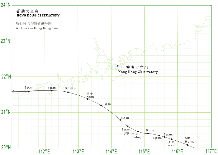
KAMMURI passed south of Hong Kong, and its closest point of approach to Hong Kong was 130 km in the SSW direction occurred between 11 to 12 HKT that day. In the afternoon, wind direction generally changed from NE to SE (figures 7a to 7e). However, winds were generally weaker in the afternoon compared with that in the morning due to the lack of rainbands in the northeastern quadrant of the storm.


Figures 5a to 5e: RADAR images at 02, 06, 10, 14 and 18 HKT, August 6th


Figures 6a to 6c: Visible (VIS) satellite imageries at 14:30 HKT (August 5th), 10:30 and 14:30 HKT (August 6th)


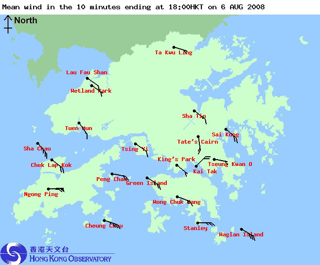
Figures 7a to 7e: Wind direction and speed at 02, 06, 10, 14 and 18 HKT, August 6th
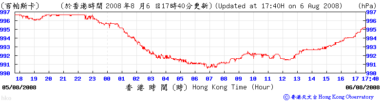
Figure 8: Mean Sea Level Pressure recorded at HKO during the passage of KAMMURI
| Landfall and Subsequent Track |
KAMMURI accelerated to the WNW in the afternoon of August 6th, and skirted Shangchuan Dao (上川島) near 16 HKT. As winds started to subside, the HKO replaced the Number 8 Signal with the Strong Wind Signal Number 3 at 17:15 HKT. The storm made landfall near Yangjiang (陽江) at 20 HKT and travelled along the coast of western Guangdong and eastern Guangxi.
The HKO issued the Standby Signal Number 1 at 04:15 HKT on August 7th as strong winds were confined to offshore waters and high grounds. All signals were cancelled at 07:15 HKT when KAMMURI was 490 km WSW of Hong Kong. KAMMURI continued to track W into northern Vietnam that night and gradually weakened into an area of low pressure. The remnants of KAMMURI later moved back into the Gulf of Tonkin (Beibu Wan) as steered by the southwesterly airstream south of the disturbance; it tracked inland again before becoming a tropical cyclone.
| Charts and Figures |
Table 1: Track data from HKWW:
YYMMDDZZ Lat Long Wind |
Table 2: Maximum gust and 60-minute average wind speed recorded in Hong Kong from HKO:
| Maximum Gust | Maximum Hourly Wind | |||||||
| Station | Direction | Speed (km/h) | Date/Month | Time | Direction | Speed (km/h) | Date/Month | Time |
| Bluff Head (Stanley) | NNE | 113 | 6/8 | 03:41 | ENE | 62 | 6/8 | 09:00 |
| Central Pier | E | 96 | 6/8 | 08:28 | E | 56 | 6/8 | 08:00 |
| Cheung Chau | NE | 124 | 6/8 | 09:13 | ENE | 83 | 6/8 | 10:00 |
| Cheung Sha Wan | NE | 96 | 6/8 | 08:14 | NE | 31 | 6/8 | 05:00 |
| NE | 31 | 6/8 | 06:00 | |||||
| Green Island | ENE | 126 | 6/8 | 06:56 | ENE | 56 | 6/8 | 08:00 |
| Hong Kong International Airport | E | 90 | 6/8 | 08:44 | E | 58 | 6/8 | 12:00 |
| Kai Tak | NE | 101 | 6/8 | 05:26 | E | 47 | 6/8 | 11:00 |
| King's Park | ESE | 85 | 6/8 | 10:32 | E | 36 | 6/8 | 10:00 |
| Lau Fau Shan | E | 92 | 6/8 | 10:25 | E | 47 | 6/8 | 12:00 |
| E | 92 | 6/8 | 11:43 | |||||
| Ngong Ping | ENE | 227 | 6/8 | 10:09 | E | 166 | 6/8 | 11:00 |
| North Point | E | 101 | 6/8 | 08:03 | E | 52 | 6/8 | 09:00 |
| Peng chau | NE | 112 | 6/8 | 07:12 | ENE | 75 | 6/8 | 09:00 |
| Ping Chau | ENE | 75 | 6/8 | 05:59 | E | 25 | 6/8 | 06:00 |
| Sai Kung | NE | 104 | 6/8 | 07:23 | ENE | 58 | 6/8 | 08:00 |
| Sha Chau | E | 83 | 6/8 | 12:12 | E | 54 | 6/8 | 13:00 |
| Sha Lo Wan | E | 103 | 6/8 | 08:27 | E | 54 | 6/8 | 12:00 |
| Sha Tin | NE | 77 | 6/8 | 08:41 | NE | 30 | 6/8 | 09:00 |
| Shek Kong | E | 92 | 6/8 | 10:29 | E | 40 | 6/8 | 10:00 |
| E | 40 | 6/8 | 12:00 | |||||
| Star Ferry (Kowloon) | ESE | 90 | 6/8 | 10:24 | E | 54 | 6/8 | 10:00 |
| Ta Kwu Ling | ENE | 85 | 6/8 | 09:12 | ENE | 31 | 6/8 | 08:00 |
| Tai Mo Shan | E | 146 | 6/8 | 08:56 | E | 96 | 6/8 | 11:00 |
| Tate's Cairn | E | 142 | 6/8 | 06:25 | E | 96 | 6/8 | 11:00 |
| E | 142 | 6/8 | 10:08 | |||||
| Tsak Yue Wu | ENE | 65 | 6/8 | 07:35 | NE | 20 | 5/8 | 23:00 |
| Tseung Kwan O | NE | 85 | 6/8 | 05:26 | NE | 27 | 6/8 | 03:00 |
| Tsing Yi Shell Oil Depot | ESE | 85 | 6/8 | 10:13 | ESE | 31 | 6/8 | 11:00 |
| Tuen Mun Government Offices | SE | 79 | 6/8 | 19:59 | SE | 31 | 6/8 | 22:00 |
| Waglan Island | E | 140 | 6/8 | 06:44 | E | 96 | 6/8 | 07:00 |
| Wetland Park | E | 75 | 6/8 | 11:19 | ENE | 34 | 6/8 | 08:00 |
| Wong Chuk Hang | ESE | 101 | 6/8 | 10:17 | ESE | 45 | 6/8 | 12:00 |
Table 3: Rainfall contributed by KAMMURI from HKO (figures in brackets are based on incomplete hourly data):
| Station | 4-Aug | 5-Aug | 6-Aug | 7-Aug | Total | |
| Hong Kong Observatory | Trace | 6.1 | 74.1 | 72.3 | 152.5 | |
| Cheung Chau (CCH) | 0.0 | 1.5 | 37.5 | 58.5 | 97.5 | |
| Hong Kong International Airport (HKA) | Trace | 1.4 | 84.1 | 88.0 | 173.5 | |
| H12 | Mid Levels | [0.0] | [7.0] | [63.5] | [47.0] | [117.5] |
| H19 | Shau Kei Wan | 0.0 | 13.0 | 62.0 | 55.5 | 130.5 |
| H21 | Repulse Bay | 0.0 | 12.0 | 68.5 | 46.5 | 127.0 |
| K04 | Jordan Valley | 0.0 | [3.5] | [74.0] | [20.0] | [97.5] |
| K06 | So Uk Estate | 0.0 | [5.0] | [69.0] | [55.5] | [129.5] |
| N05 | Fanling | 0.0 | 4.0 | [64.0] | 73.5 | [141.5] |
| N06 | Kwai Chung | 0.0 | 3.0 | 90.0 | 100.5 | 193.5 |
| N09 | Sha Tin | [0.0] | [6.0] | 115.0 | [7.0] | [128.0] |
| N12 | Yuen Long | 0.0 | 2.5 | 77.5 | 33.5 | 113.5 |
| N13 | High Island | 0.0 | 8.5 | 37.0 | [0.5] | [46.0] |
| N17 | Tung Chung | 0.0 | 4.0 | 104.5 | 114.5 | 223.0 |
| R21 | Tap Shek Kok | 0.0 | [4.0] | 62.0 | 66.5 | [132.5] |
| R26 | Shek Kong | 0.0 | 3.0 | [102.0] | - | [105.0] |
| R31 | Tai Mei Tuk | 0.0 | 3.0 | 58.5 | 7.5 | 69.0 |
Last Accessed: Sun Sep 08 2024 12:45:52 HKT
Last Modified: Mon Jul 24 2023
