
TC Watch > Selected TC Review > 200802W (NEOGURI) [Refresh]
 200802W (NEOGURI) - Profile 200802W (NEOGURI) - Profile |
(First issued on May 1st, 2008; final version issued on May 8th, 2008)
Brief profile of NEOGURI:
| JTWC number | 02W |
| International number | 0801 |
| Period of existence | 14 April, 2008 08 HKT to 19 April, 2008 20 HKT |
| Lifetime | 5.5 days |
| Maximum 1-minute wind (JTWC) | 95 knots |
| Minimum pressure (JTWC) | 952 hPa |
| Highest TC signal by HKO (if applicable) | 3 (Strong wind signal) |
| Closest point of approach by HKO (if applicable) | NW 140km (real-time warning) / 150km (TC report) |
| Time of closest approach by HKO (if applicable) | 19 April, 2008 23 HKT (real-time warning) / 19 April, 2008 20 HKT (TC report) |
| Lowest pressure recorded at HKO (if applicable) | 1003.9 hPa (19 April, 2008 18 HKT) |
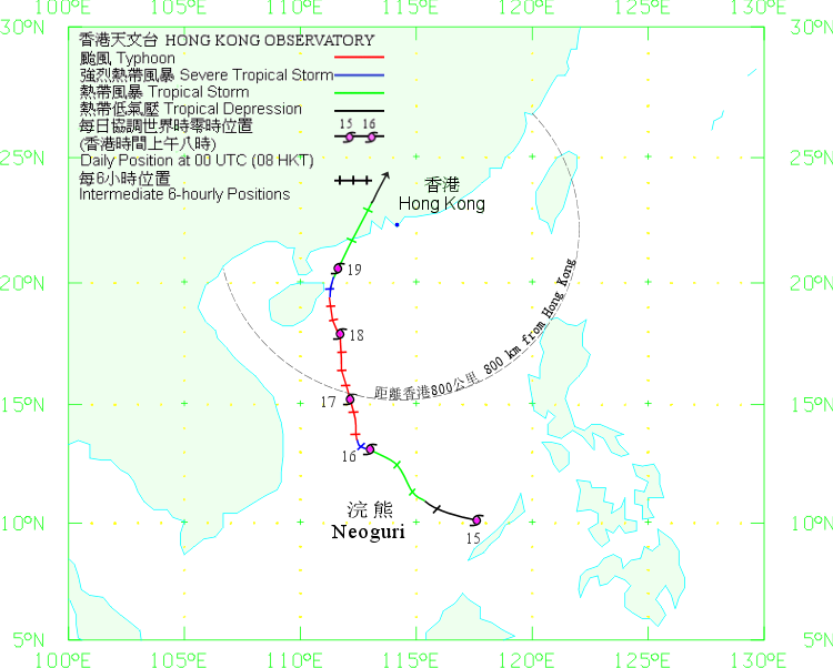
TC signals for Hong Kong & Track:
Table:
Signal |
Date and time |
Distance from HK |
Predicted movement |
Max. 10-min winds |
 |
2008/04/17 (THU) 16:15 HKT |
SSW 730 km |
NNW at 10 km/h |
130 km/h (70 knots, Cat. 1) |
 |
2008/04/18 (FRI) 20:40 HKT |
SW 450 km |
N at 14 km/h |
130 km/h (70 knots, Cat. 1) |
 |
2008/04/20 (SUN) 13:30 HKT |
NNW 150 km |
NE at 22 km/h |
38 km/h (20 knots, LPA) |
Figure: (Track courtesy of Lorenzo. Data from HKO.)
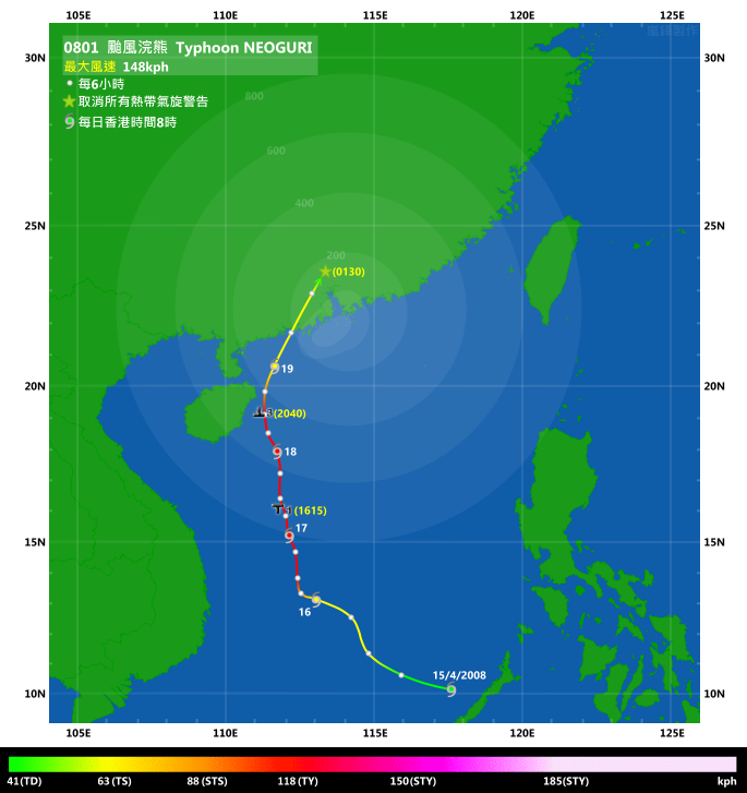
TC track from HKWW:
TC track from HKO:
| Past HKWW Bulletins on NEOGURI |
Please click here for bulletins on NEOGURI.
| Storm Formation |
ECMWF was among the first numerical forecasts that predicted the formation of NEOGURI, dating back to as early as 10 days before the actual formation of the storm.
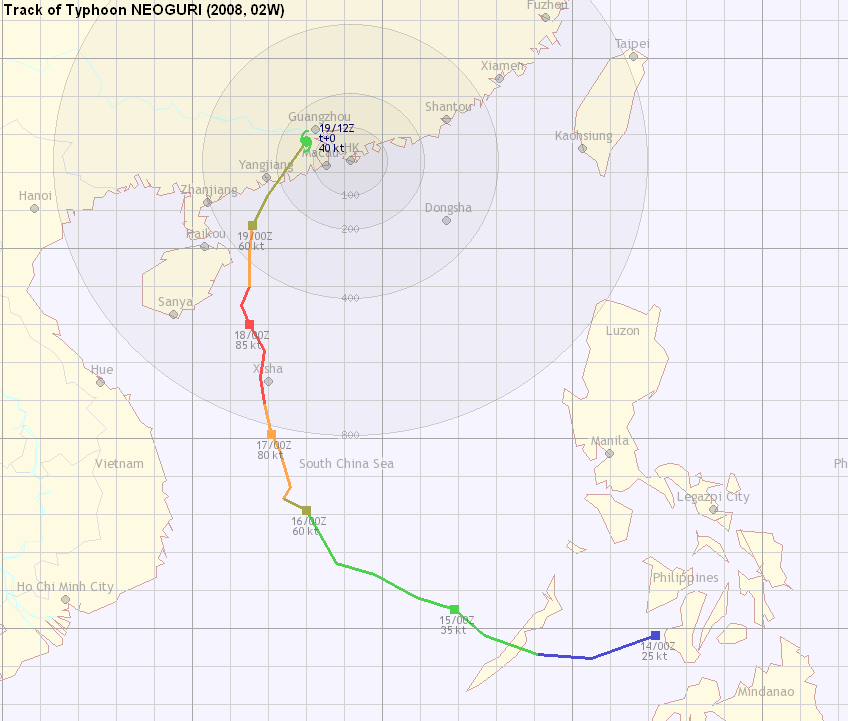
NEOGURI developed as a tropical disturbance (99W) east of the Philippines on 12th April, 2008 from an easterly wave. Subject to low wind shears and good environmental conditions, it gained strength slightly during 12th to 14th April, 2008. It finally managed to strengthen into a tropical depression after traversing Mindanao, in South China Sea on April 14th. PAGASA upgraded this disturbance shortly afterwards, and JMA issued gale warning for this tropical depression at 06 UTC, 15 April, 2008. At the same time, HKO also recognized this tropical depression, but had put it at a rather westward position (west of 115E) which would lead to an early northerly track as shown in HKO's track for NEOGURI (figure 1).
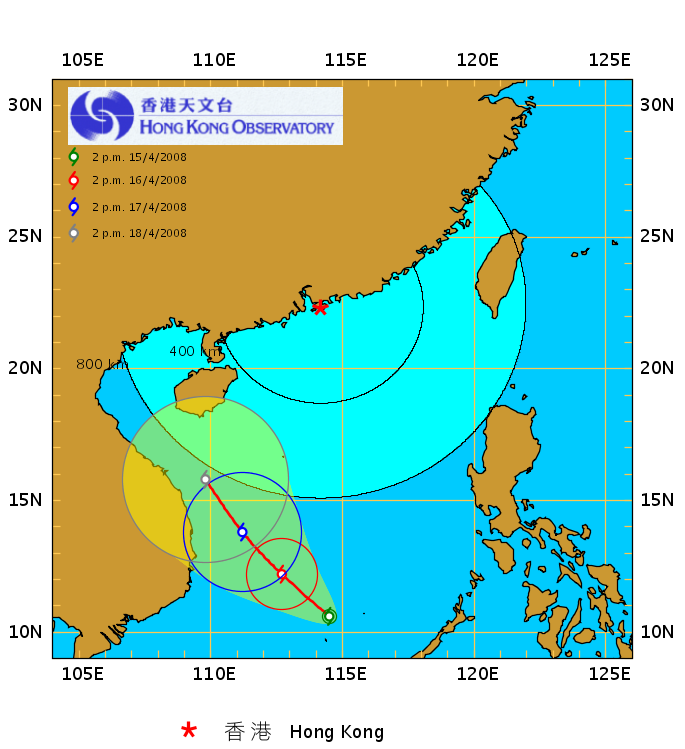
Figure 1 - HKO's first forecast track when it upgraded NEOGURI into a tropical depression

Figure 2 - JTWC's first track when it upgraded NEOGURI into a tropical depression
| Storm Development |
NEOGURI was intially positioned south to southwest of the western edge of a subtropical ridge, allowing the system to move west to west-northwest steadily in the first two days of its formation. The anticyclone provided the necessary outflow channel, and enabled the system to gain tropical storm (TS) strength later on April 14th. JMA followed suit, but HKO did not see any sufficient reason to upgrade it into TS status until 21 UTC on April 15th. At this time, as it was predicted that the steering subtropical ridge would retreat significantly later in the forecast period, nearly all agencies expected a NW or even poleward turn, allowing NEOGURI to edge closer to western Guangdong or Hainan Island.
Due to increased vertical wind shear, intensification diminished on the 15th, but the warm water supported its development and it finally gained severe tropical storm (STS) status, according to JMA, on early April 16th. HKO also upgraded NEOGURI into a STS at 03 UTC on April 16th. The arriving westerly trough improved NEOGURI's upper divergence channel, and NEOGURI intensified into a typhoon during daytime on April 16th. NEOGURI started to take a more northwesterly track, heading towards Xisha (Paracel Islands).
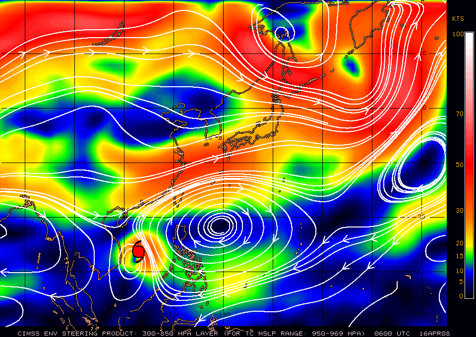
Figure 3 - CIMSS steering chart at 06 UTC, 16th April 2008
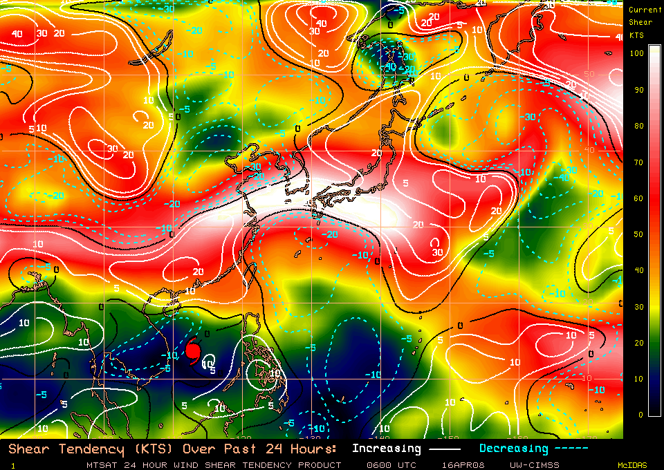
Figure 4 - CIMSS wind shear tendency chart at 06 UTC, 16th April 2008
| Tropical Cyclone Signals and Intensification of NEOGURI |
Turning NNW on April 17th, NEOGURI reached 800km within HK near 03 UTC the same day, with continuing intensification to a category 2 typhoon. As NEOGURI was moving closer to the territory, HKO and SMG of Macau issued the Standby Signal Number 1 at 08:15 UTC (16:15 HKT) on April 17th. At that time, NEOGURI was only tens of kilometres away from Xisha, and wind speed in excess of 60 km/h was recorded with the lowest central pressure of 990 hPa (also in figure 5). The intensification of the storm was not hampered by lower sea surface temperatures at this moment, and NEOGURI reached its peak intensity of 95 knots at 12 UTC the same day (figure 6).
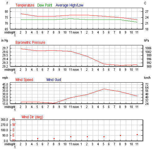
Figure 5 - Weather elements at Xisha Dao on 17th April, 2008 (Weather Underground)
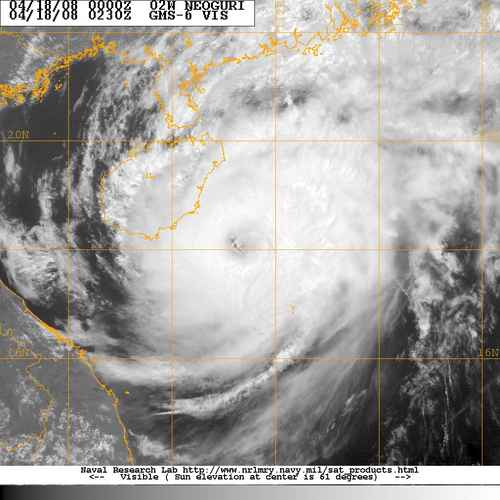
Figure 6 - NEOGURI at peak intensity
By now, the ridge has retreated to the extent which allowed NEOGURI to move poleward, heading towards the eastern edge of Hainan. There were several linkages between the system and the westerlies (which was at about 22N), but the durations were brief and the storm did not present much eastward component before skirting Hainan Island.
As NEOGURI made its way north in the South China Sea, HKO issued the Strong Wind Signal Number 3 at 12:40 UTC (20:40 HKT) on April 18th, the earliest Number 3 tropical cyclone signal since the Second World War. SMG followed in five minutes, and at that time winds were picking up at various locations in the territory. In the 7-day weather report issued shortly afterwards, HKO predicted that easterly winds of "Force 6 to 7" were expected and "Force 8" could be observed occasionally offshore and on high ground, due to the combined effect of NEOGURI and a (weak) northeast monsoon.
| Weakening Trend and its Landfalls |
As NEOGURI continued its northward track Hainan autorities declared that the storm had made landfall at Longlou County (龍樓鎮) of Wenchang City (文昌市) at 14:30 UTC (22:30 HKT) on April 18th, with central wind speed of 30 m/s (108 km/h) or STS strength, which was the earliest storm in a year to make landfall at Hainan ever (figure 7). However, from satellite imagery it was unclear whether or not landfall had actually occurred, and some people attributed this to the different definitions of "making landfall" among different agencies.
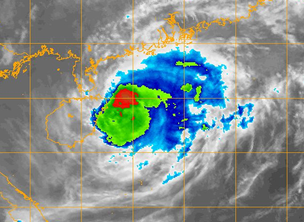
Figure 7 - NEOGURI making its first landfall at Hainan, according to CMA
It was at this point that NEOGURI started to recurve towards the northeast, and as it was approaching Macau, SMG issued the Number 8 (SE) Gale or Storm Signal at 05:30 UTC (13:30 HKT) on April 19th. Transportation between Macau and Hong Kong came to a halt shortly afterwards and continued for the rest of that Saturday afternoon.
Eventually the combat between NEOGURI and the worsening environment came to an end as NEOGURI confronted sea surface temperatures of as low as 23 degrees with strengthening wind shear. NEOGURI finally succumbed and weakened rapidly as it made its "second" landfall near Dongping County (東平鎮) of Yangjiang City (陽江市) at 06:15 UTC (14:15 HKT) on April 19th (figure 8). Again this broke the record for being the earliest storm that made landfall at Guangdong. CMA gave NEOGURI a maximum central wind speed of 17 m/s (61 km/h) or merely a tropical depression at its second landfall, which was thought to be underrated judging from satellite imagery and estimation from wind speed recorded at its periphery (see links: 1 2 3).
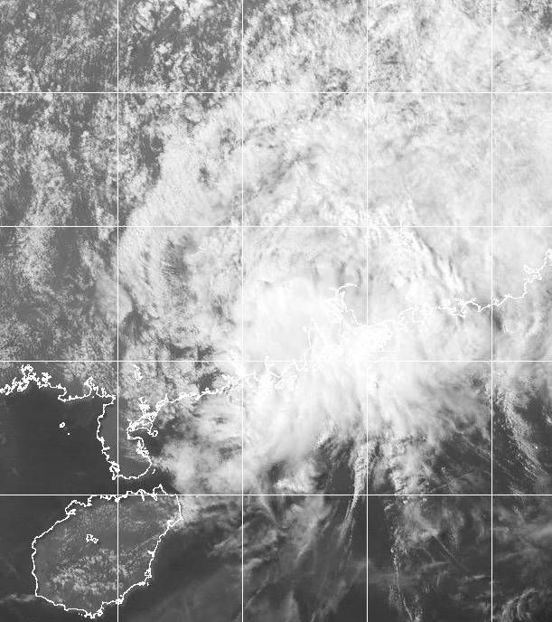
Figure 8 - NEOGURI making landfall at western Guangdong (image at 06:30 UTC [14:30 HKT], April 19th)
NEOGURI brought rather strong winds and heavy rains to Hong Kong (figures 9a, 9b and 10), and the Observatory issued the first black rainstorm warning signal at 12:15 UTC (19:15 HKT) on April 19th, which was also the earliest black rainstorm warning "in 14 years", according to HKO. At one point 5 warnings were in effect simultaneously, including the strong wind signal, thunderstorm warning, special announcement of flooding in Northern New Territories, landslip warning and black rainstorm warning signal in their order of issuance. The combination of warm, moist air driven from the southwest quadrant of the cyclone and the cool, dry air from the northeast monsoon seemed to have contributed to a warm front that passed Hong Kong later that night, causing notable increase in air temperature in various parts of the territory (figure 11).


Figures 9a and 9b - (left) accumulated rainfall between 18:30 and 19:30 HKT; (right) accumulated rainfall between 00:00 and 23:15 HKT
All times refer to that on 19th April, 2008
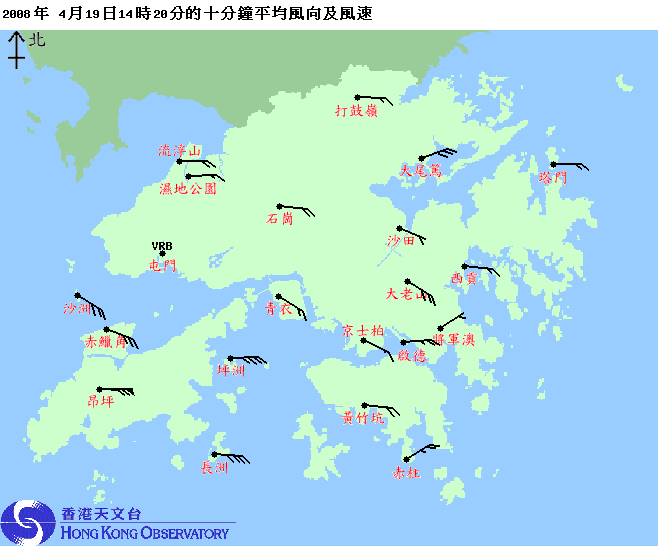
Figure 10 - 10-minute average wind speed recorded at different parts of the territory, 14:20 HKT April 19th
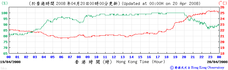
Figure 11 - Temperature profile of Hong Kong Observatory, April 19th
NEOGURI continued to weaken rapidly due to the lack of moisture from the ocean, and it passed Guangzhou shortly before midnight local time (of April 20th). At this point NEOGURI made its closest point of approach to Hong Kong, and at 17:30 UTC (01:30 HKT) April 19th (April 20th HKT) HKO declared it a low pressure area together with the cancellation of all tropical cyclone signals. JMA also downgraded NEOGURI to the same status at 18 UTC (02 HKT) April 19th/20th.
There were signs of extratropical transition when (and after) the storm has made landfall at western Guangdong, as seen from its increased linkage with the westerlies.
It is worth noticing that HKO did not do well in predicting Sunday (April 20th)'s weather conditions, mentioning "Cloudy with rain and squally thunderstorms" in every weather report (for example, here) before all signals were removed. In fact, on April 20th HK saw no rain and even with sunny intervals during the day. It seemed that the rapid weakening trend and the lack of cloud/rainbands west of the system had contributed to this forecasting error and indeed, it would have been a completely different story if the scenario that the ECMWF forecasts depicted over and over --- a landfall in the proximity of the Pearl River Estuary --- came true.
| Charts and Figures |
Table 1: Track data from HKWW:
YYMMDDZZ Lat Long Wind 08041400 098N1222E 025 08041406 092N1205E 030 08041412 093N1191E 035 08041418 098N1177E 035 08041500 105N1169E 035 08041506 108N1159E 040 08041512 114N1148E 040 08041518 117N1138E 045 08041600 131N1130E 060 08041606 134N1124E 070 08041612 137N1126E 075 08041618 147N1123E 075 08041700 151N1121E 080 08041706 159N1119E 085 08041712 166N1118E 085 08041718 173N1119E 085 08041800 180N1115E 085 08041806 185N1113E 085 08041812 190N1115E 080 08041818 198N1115E 075 08041900 206N1116E 060 08041906 214N1120E 055 08041912 228N1130E 040 |
Table 2: Maximum gust and 60-minute average wind speed recorded in Hong Kong from HKO:
| Maximum Gust | Maximum Hourly Wind | |||||||
| Station | Direction | Speed (km/h) | Date/Month | Time | Direction | Speed (km/h) | Date/Month | Time |
| Bluff Head (Stanley) |
E | 85 | 19/4 | 18:48 | E | 56 | 19/4 | 19:00 |
| Central Pier | SE | 72 | 19/4 | 21:32 | E | 43 | 19/4 | 16:00 |
| Chek Lap Kok | SW | 104 | 19/4 | 18:19 | SSW | 56 | 19/4 | 21:00 |
| S | 56 | 19/4 | 22:00 | |||||
| Cheung Chau | ESE | 117 | 19/4 | 15:21 | ESE | 76 | 19/4 | 16:00 |
| Cheung Sha Wan | ESE | 45 | 18/4 | 21:09 | E | 16 | 18/4 | 20:00 |
| E | 16 | 18/4 | 21:00 | |||||
| ENE | 16 | 19/4 | 03:00 | |||||
| Green Island | NE | 96 | 19/4 | 14:27 | SSW | 70 | 19/4 | 22:00 |
| Kai Tak | ESE | 83 | 19/4 | 13:59 | E | 45 | 19/4 | 15:00 |
| King's Park | S | 77 | 19/4 | 20:28 | E | 27 | 19/4 | 18:00 |
| Lau Fau Shan | S | 77 | 19/4 | 22:16 | S | 40 | 19/4 | 23:00 |
| Ngong Ping | E | 191 | 19/4 | 14:51 | E | 135 | 19/4 | 15:00 |
| North Point | E | 62 | 19/4 | 13:08 | E | 30 | 17/4 | 22:00 |
| Peng chau | E | 94 | 19/4 | 14:40 | E | 70 | 19/4 | 15:00 |
| Ping Chau | E | 75 | 19/4 | 15:38 | E | 30 | 19/4 | 16:00 |
| Sai Kung | SE | 67 | 19/4 | 19:24 | S | 38 | 19/4 | 23:00 |
| Sha Chau | S | 104 | 19/4 | 18:42 | SSW | 63 | 19/4 | 22:00 |
| Sha Lo Wan | E | 96 | 19/4 | 14:38 | E | 45 | 19/4 | 15:00 |
| Sha Tin | SSW | 65 | 19/4 | 21:49 | SSW | 30 | 19/4 | 23:00 |
| Shek Kong | E | 72 | 19/4 | 15:21 | E | 41 | 19/4 | 16:00 |
| Star Ferry (Kowloon) | ESE | 67 | 19/4 | 15:29 | ESE | 41 | 19/4 | 16:00 |
| Ta Kwu Ling | E | 62 | 19/4 | 18:28 | E | 25 | 19/4 | 15:00 |
| Tai Mei Tuk | ENE | 87 | 19/4 | 16:45 | ENE | 62 | 19/4 | 17:00 |
| Tai Mo Shan | ESE | 128 | 19/4 | 15:20 | ESE | 90 | 19/4 | 15:00 |
| Tap Mun | ESE | 85 | 19/4 | 18:52 | E | 41 | 19/4 | 17:00 |
| Tate's Cairn | ESE | 94 | 19/4 | 15:17 | ESE | 58 | 19/4 | 16:00 |
| Tsak Yue Wu | ENE | 58 | 19/4 | 15:04 | ENE | 25 | 19/4 | 15:00 |
| Tseung Kwan O | ESE | 68 | 19/4 | 19:01 | SSW | 20 | 19/4 | 22:00 |
| Tsing Yi Shell Oil Depot | ESE | 68 | 19/4 | 15:20 | SSE | 36 | 19/4 | 20:00 |
| Tuen Mun | SSE | 72 | 19/4 | 18:59 | SSE | 31 | 19/4 | 20:00 |
| Waglan Island | E | 104 | 19/4 | 16:32 | SSE | 76 | 19/4 | 21:00 |
| Wetland Park | E | 51 | 19/4 | 14:33 | E | 23 | 19/4 | 13:00 |
| E | 23 | 19/4 | 14:00 | |||||
| Wong Chuk Hang | ESE | 83 | 19/4 | 14:08 | ESE | 38 | 19/4 | 16:00 |
Table 3: Rainfall contributed by NEOGURI from HKO (figures in brackets are based on incomplete hourly data):
| Station | 17-Apr | 18-Apr | 19-Apr | 20-Apr | Total | |
| Hong Kong Observatory | Trace | Trace | 237.4 | 0.0 | 237.4 | |
| Chek Lap Kok (HKA) | Trace | Trace | 172.1 | 0.0 | 172.1 | |
| Cheung Chau (CCH) | 0.0 | 0.0 | 115.5 | 0.0 | 115.5 | |
| H12 | Mid Levels | 0.0 | 0.0 | 202.0 | 0.0 | 202.0 |
| H19 | Shau Kei Wan | 0.0 | 0.0 | 193.5 | 0.0 | 193.5 |
| H21 | Repulse Bay | 0.0 | 0.0 | 184.0 | 0.0 | 184.0 |
| K04 | Jordan Valley | [0.0] | [0.0] | [229.5] | 0.0 | [229.5] |
| K06 | So Uk Estate | 0.0 | 0.0 | [203.0] | 0.0 | [203.0] |
| N05 | Fanling | 0.0 | 0.0 | 198.5 | 0.0 | 198.5 |
| N06 | Kwai Chung | 0.0 | 0.0 | 182.5 | 0.0 | 182.5 |
| N09 | Sha Tin | 0.0 | 0.0 | 262.0 | 0.0 | 262.0 |
| N12 | Yuen Long | 0.0 | 0.0 | 145.0 | 0.0 | 145.0 |
| N13 | High Island | 0.0 | 0.0 | 137.5 | 0.0 | 137.5 |
| R21 | Tap Shek Kok | 0.0 | 0.0 | 103.0 | 0.0 | 103.0 |
| R26 | Shek Kong | 0.0 | 0.0 | 151.0 | 0.0 | 151.0 |
| R31 | Tai Mei Tuk | 0.0 | 0.0 | 200.5 | 1.0 | 201.5 |
Last Accessed: Sun Sep 08 2024 12:47:23 HKT
Last Modified: Mon Jul 24 2023
