TC Watch / 熱帶氣旋
> Latest TC Info 最新熱帶氣旋資訊 [Refresh 更新 ]
Current
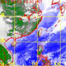
TC Map 即時氣旋資訊
1. 07W (HAGIBIS 海貝思)
Name of System 系統名稱
TS HAGIBIS 熱帶風暴 海貝思
JTWC No. / Int'l No. JTWC
編號 / 國際編號
07W / 1407
Bulletin Number 發佈編號
#5 FINAL BULLETIN 最後發佈
Time of
Report 報告時間
2014/06/18, 12:45 HKT (04:45 UTC)
Time of
Observation 觀測時間
2014/06/18,
08:00 HKT (00:00 UTC)
Position 位置
30.2°N, 138.5°E
Maximum Gust 最高陣風
50 knots 節 (95 km/h 公里每小時)
1-min. Average Wind Speed 1分鐘平均風速
40 knots 節 (75 km/h 公里每小時)
10-min. Average Wind Speed 10分鐘平均風速
35 knots 節 (65 km/h 公里每小時)
Pressure 氣壓
996 hPa 百帕斯卡
Past 6-hr Movement 過去6小時移向和移速
E 東 (081°) at 42 knots 節 (78 km/h 公里每小時)
Area(s) affected 受影響地區
N/A 不適用
Forecast
Track 預測路徑圖
Forecast
Positions 預測位置資料
Tau HK Time Lat. Long. Movement 1-min Average Strength t+0 06/18 (Wed) 08:00 30.2°N 138.5°E ENE 東北偏東 (076°) 75 km/h 40 kt (74 km/h) TS 熱帶風暴 t+12 06/18 (Wed) 20:00 31.8°N 147.8°E N/A 40 kt (74 km/h) Ext Cyclone 溫帶氣旋
Overview 總覽
HAGIBIS is moving E rapidly. At 8 am, HAGIBIS was centred about 620 km (340 NM) S of Tokyo.
海貝思向東快速移動。在上午 8 時, 海貝思集結在東京以南約 620 公里 (340 海里)。
TC
Naming 氣旋命名
HAGIBIS is the 52nd name in the tropical cyclone name list. It was contributed by the Philippines, meaning fast. This name was used in 2002 and 2007.
海貝思為熱帶氣旋名稱列表中第 52 個名字,由菲律賓提供,意思為快捷。此名曾於 2002 及 2007 年使用。
Movement
Analysis 路徑分析
HAGIBIS is now situated north of the subtropical ridge, and the westerlies is expected to push HAGIBIS quickly to the east.
海貝思現處於副熱帶高壓脊北沿,在西風帶的牽引下海貝思將快速向東移動。
Intensity
Analysis 強度分析
Current T-number 現時的 T 號碼: N/A 不適用
HAGIBIS has started extratropical transition, and this process should be completed in less than 12 hours.
海貝思正轉化為 溫帶氣旋,預料會於 12 小時內完成。
Effects on
Hong Kong 對香港的影響
No threat to Hong Kong is expected within the next 72 hours.
預料海貝思於未來的 72 小時將不會對香港構成影響。
Next Update
下次更新
This is the final bulletin on HAGIBIS.
這是本站對海貝思的最後一次發佈。
Other Images
其他圖像
Probabilities
of TC Signals from HKO 香港天文台發出 / 取消熱帶氣旋警告信號的機率
N/A 不適用
Name of System 系統名稱
TS HAGIBIS 熱帶風暴 海貝思
JTWC No. / Int'l No. JTWC
編號 / 國際編號
07W / 1407
Bulletin Number 發佈編號
#4 REISSUED 重新發佈
Time of
Report 報告時間
2014/06/17, 16:00 HKT (08:00 UTC)
Time of
Observation 觀測時間
2014/06/17,
14:00 HKT (06:00 UTC)
Position 位置
28.5°N, 125.9°E
Maximum Gust 最高陣風
50 knots 節 (95 km/h 公里每小時)
1-min. Average Wind Speed 1分鐘平均風速
40 knots 節 (75 km/h 公里每小時)
10-min. Average Wind Speed 10分鐘平均風速
35 knots 節 (65 km/h 公里每小時)
Pressure 氣壓
996 hPa 百帕斯卡
Past 6-hr Movement 過去6小時移向和移速
E 東 (079°) at 28 knots 節 (51 km/h 公里每小時)
Area(s) affected 受影響地區
East China Sea 東海
Forecast
Track 預測路徑圖
Forecast
Positions 預測位置資料
Tau
HK Time
Lat.
Long.
Movement
1-min Average Strength
t+0
06/17 (Tue) 14:00
28.5°N
125.9°E
ENE 東北偏東 (074°) 58 km/h
40 kt (74 km/h)
TS 熱帶風暴
t+12
06/18 (Wed) 02:00
30.1°N
132.9°E
ENE 東北偏東 (073°) 65 km/h
40 kt (74 km/h)
TS 熱帶風暴
t+24
06/18 (Wed) 14:00
31.9°N
140.8°E
N/A
40 kt (74 km/h)
Ext Cyclone 溫帶氣旋
Overview 總覽
HAGIBIS re-entered open seas last night and regained structure as moisture is fed into the storm again. Wind field analysis shows gale force winds near HAGIBIS's centre. Bulletins are thus reissued for this system. At 2 pm, HAGIBIS was centred about 310 km (170 NM) NW of Okinawa.
海貝思昨晚進入東海。受惠於海面的濕氣供應,海貝思結構轉好,風場分析顯示其中心附近再次出現烈風區,本站重新對其作出發佈。在下午 2 時, 海貝思集結在沖繩島西北約 310 公里 (170 海里)。
TC
Naming 氣旋命名
HAGIBIS is the 52nd name in the tropical cyclone name list. It was contributed by the Philippines, meaning fast. This name was used in 2002 and 2007.
海貝思為熱帶氣旋名稱列表中第 52 個名字,由菲律賓提供,意思為快捷。此名曾於 2002 及 2007 年使用。
Movement
Analysis 路徑分析
HAGIBIS is now situated north of the subtropical ridge, and the westerlies is expected to push HAGIBIS quickly to the east or ENE.
海貝思現處於副熱帶高壓脊北沿,在西風帶的牽引下海貝思將快速向東或東北偏東移動。
Intensity
Analysis 強度分析
Current T-number 現時的 T 號碼: T2.5/2.5/D1.0/24 HRS
HAGIBIS weakened while on land. However it stayed inland for shorter duration than expected, and its structure improved quickly after entering East China Sea. The storm is subjected to rather high vertical wind shear with low sea temperatures (below 26 degrees). It is expected to transform into an extratropical cyclone within 24 hours.
海貝思於陸地減弱,但它 逗留內陸的時間比預期短,出海後結構明顯改善。風暴正處於較高垂直風切變及低海溫 (低於 26 度) 的地區,預料會於 24 小時內轉化為溫帶氣旋。
Effects on
Hong Kong 對香港的影響
No threat to Hong Kong is expected within the next 72 hours.
預料海貝思於未來的 72 小時將不會對香港構成影響。
Next Update
下次更新
2014/06/18 (Wed 三), afternoon 下午 (or earlier 或更早)
Other Images
其他圖像
Probabilities
of TC Signals from HKO 香港天文台發出 / 取消熱帶氣旋警告信號的機率
N/A 不適用
Name of System 系統名稱
TD HAGIBIS 熱帶低氣壓 海貝思
JTWC No. / Int'l No. JTWC
編號 / 國際編號
07W / 1407
Bulletin Number 發佈編號
#3 FINAL BULLETIN 最後發佈
Time of
Report 報告時間
2014/06/16, 09:30 HKT (01:30 UTC)
Time of
Observation 觀測時間
2014/06/16,
08:00 HKT (00:00 UTC)
Position 位置
24.0°N, 116.8°E
Maximum Gust 最高陣風
40 knots 節 (75 km/h 公里每小時)
1-min. Average Wind Speed 1分鐘平均風速
30 knots 節 (55 km/h 公里每小時)
10-min. Average Wind Speed 10分鐘平均風速
25 knots 節 (45 km/h 公里每小時)
Pressure 氣壓
1000 hPa 百帕斯卡
Past 6-hr Movement 過去6小時移向和移速
N 北 (010°) at 5 knots 節 (9 km/h 公里每小時)
Area(s) affected 受影響地區
Southeastern Guangdong 廣東東南部
Forecast
Track 預測路徑圖
Forecast
Positions 預測位置資料
Tau
HK Time
Lat.
Long.
Movement
1-min Average Strength
Distance/Bearing from HK
t+0
06/16 (Mon) 08:00
24.0°N
116.8°E
NNE 東北偏北 (019°) 8 km/h
30 kt (56 km/h)
TD 熱帶低氣壓
NE 東北 328 km
t+12
06/16 (Mon) 20:00
24.8°N
117.1°E
N/A
20 kt (37 km/h)
LPA 低壓區
NE 東北 408 km
Overview 總覽
HAGIBIS made landfall near Shantou last night and has weakened into a tropical depression. At 8 am, HAGIBIS was centred about 330 km (180 NM) NE of Hong Kong.
海貝思昨晚於汕頭附近登陸,其後減弱為熱帶低氣壓。在上午 8 時, 海貝思集結在香港東北約 330 公里 (180 海里)。
TC
Naming 氣旋命名
HAGIBIS is the 52nd name in the tropical cyclone name list. It was contributed by the Philippines, meaning fast. This name was used in 2002 and 2007.
海貝思為熱帶氣旋名稱列表中第 52 個名字,由菲律賓提供,意思為快捷。此名曾於 2002 及 2007 年使用。
Movement
Analysis 路徑分析
HAGIBIS will move N to NNE along the western periphery of the subtropical ridge.
海貝思將沿副熱帶高壓脊西部向北至東北偏北移動。
Intensity
Analysis 強度分析
Current T-number 現時的 T 號碼: N/A 不適用
HAGIBIS is losing convections rapidly and will dissipate soon.
海貝思正急速喪失對流,將於短時間內消散 。
Effects on
Hong Kong 對香港的影響
No significant threat to Hong Kong is expected within the next 72 hours.
預料海貝思於未來的 72 小時將不會對香港構成明顯影響。
Next Update
下次更新
This is the final bulletin on HAGIBIS.
這是本站對海貝思的最後一次發佈。
Other Images
其他圖像
Probabilities
of TC Signals from HKO 香港天文台發出 / 取消熱帶氣旋警告信號的機率
N/A 不適用
Name of System 系統名稱
TS HAGIBIS 熱帶風暴 海貝思
JTWC No. / Int'l No. JTWC
編號 / 國際編號
07W / 1407
Bulletin Number 發佈編號
#2
Time of
Report 報告時間
2014/06/15, 14:45 HKT (06:45 UTC)
Time of
Observation 觀測時間
2014/06/15,
14:00 HKT (06:00 UTC)
Position 位置
22.8°N, 116.8°E
Maximum Gust 最高陣風
55 knots 節 (100 km/h 公里每小時)
1-min. Average Wind Speed 1分鐘平均風速
45 knots 節 (85 km/h 公里每小時)
10-min. Average Wind Speed 10分鐘平均風速
40 knots 節 (75 km/h 公里每小時)
Pressure 氣壓
992 hPa 百帕斯卡
Past 6-hr Movement 過去6小時移向和移速
N 北 (007°) at 8 knots 節 (15 km/h 公里每小時)
Area(s) affected 受影響地區
Eastern Guangdong coast 廣東東部沿岸
Forecast
Track 預測路徑圖
Forecast
Positions 預測位置資料
Tau
HK Time
Lat.
Long.
Movement
1-min Average Strength
Distance/Bearing from HK
t+0
06/15 (Sun) 14:00
22.8°N
116.8°E
N 北 (009°) 10 km/h
45 kt (83 km/h)
TS 熱帶風暴
ENE 東北偏東 276 km
t+12
06/16 (Mon) 02:00
23.9°N
117.0°E
NNE 東北偏北 (021°) 12 km/h
35 kt (65 km/h)
TS 熱帶風暴
ENE 東北偏東 340 km
t+24
06/16 (Mon) 14:00
25.1°N
117.5°E
NNE 東北偏北 (024°) 12 km/h
25 kt (46 km/h)
TD 熱帶低氣壓
NE 東北 460 km
t+36
06/17 (Tue) 02:00
26.3°N
118.1°E
N/A
20 kt (37 km/h)
LPA 低壓區
NE 東北 597 km
Overview 總覽
HAGIBIS intensified and continued to move north with some westward motion. In Hong Kong, the Standby Signal was in force from 5:40 pm yesterday to 1:20 pm today. At 2 pm, HAGIBIS was centred about 280 km (150 NM) ENE of Hong Kong.
海貝思略為增強,大致向北移動且有少許偏西分量。本港方面,一號戒備信號於昨天下午 5 時 40 分發出,生效至今天下午 1 時 20 分。在下午 2 時, 海貝思集結在香港東北偏東約 280 公里 (150 海里)。
TC
Naming 氣旋命名
HAGIBIS is the 52nd name in the tropical cyclone name list. It was contributed by the Philippines, meaning fast. This name was used in 2002 and 2007.
海貝思為熱帶氣旋名稱列表中第 52 個名字,由菲律賓提供,意思為快捷。此名曾於 2002 及 2007 年使用。
Movement
Analysis 路徑分析
HAGIBIS is expected to make landfall near Shantou soon, and will move N to NNE along the western periphery of the subtropical ridge.
海貝思即將於汕頭一帶登陸,預料將沿副熱帶高壓脊西部向北至東北偏北移動。
Intensity
Analysis 強度分析
Current T-number 現時的 T 號碼: T3.0/3.5/D0.5/24 HRS W0.5/12 HRS
HAGIBIS maintains a symmetric circulation. The storm will weaken as it makes landfall, and is expected to dissipate by t+36.
海貝思環流保持對稱 ,預料於登陸後減弱,並於 36 小時內消散。
Effects on
Hong Kong 對香港的影響
Winds in Hong Kong will back to southwest tonight. There will be some showers, and swells continue to be a danger over open seas. As HAGIBIS makes landfall, its effects on the territory will diminish over the next two days.
香港風向將於今晚逆轉為西南。驟雨將繼續影響本港,而海面會有湧浪。隨著海貝思登陸,其對香港的影響將於未來兩天消退。
Next Update
下次更新
2014/06/16 (Mon 一), afternoon 下午 (or earlier 或更早)
Other Images
其他圖像
Probabilities
of TC Signals from HKO 香港天文台發出 / 取消熱帶氣旋警告信號的機率
N/A 不適用
Name of System 系統名稱
TS HAGIBIS 熱帶風暴 海貝思
JTWC No. / Int'l No. JTWC
編號 / 國際編號
07W / 1407
Bulletin Number 發佈編號
#1
Time of
Report 報告時間
2014/06/14, 16:45 HKT (08:45 UTC)
Time of
Observation 觀測時間
2014/06/14,
14:00 HKT (06:00 UTC)
Position 位置
20.9°N, 117.2°E
Maximum Gust 最高陣風
45 knots 節 (85 km/h 公里每小時)
1-min. Average Wind Speed 1分鐘平均風速
35 knots 節 (65 km/h 公里每小時)
10-min. Average Wind Speed 10分鐘平均風速
30 knots 節 (55 km/h 公里每小時)
Pressure 氣壓
994 hPa 百帕斯卡
Past 6-hr Movement 過去6小時移向和移速
N 北 (360°) at 7 knots 節 (13 km/h 公里每小時)
Area(s) affected 受影響地區
Northern South China Sea 南海北部
Forecast
Track 預測路徑圖
Forecast
Positions 預測位置資料
Tau
HK Time
Lat.
Long.
Movement
1-min Average Strength
Distance/Bearing from HK
t+0
06/14 (Sat) 14:00
20.9°N
117.2°E
N 北 (360°) 8 km/h
35 kt (65 km/h)
TS 熱帶風暴
ESE 東南偏東 350 km
t+12
06/15 (Sun) 02:00
21.8°N
117.2°E
N 北 (360°) 8 km/h
40 kt (74 km/h)
TS 熱帶風暴
E 東 317 km
t+24
06/15 (Sun) 14:00
22.7°N
117.2°E
NNE 東北偏北 (014°) 11 km/h
45 kt (83 km/h)
TS 熱帶風暴
E 東 314 km
t+36
06/16 (Mon) 02:00
23.8°N
117.5°E
NNE 東北偏北 (016°) 13 km/h
45 kt (83 km/h)
TS 熱帶風暴
ENE 東北偏東 379 km
t+48
06/16 (Mon) 14:00
25.1°N
117.9°E
NNE 東北偏北 (028°) 12 km/h
35 kt (65 km/h)
TS 熱帶風暴
NE 東北 491 km
t+72
06/17 (Tue) 14:00
27.3°N
119.2°E
N/A
20 kt (37 km/h)
LPA 低壓區
NE 東北 752 km
Overview 總覽
Tropical disturbance 95W over the South China Sea intensified into a tropical depression today. It later strengthened into a tropical storm (07W) and was named HAGIBIS. At 2 pm, HAGIBIS was centred about 350 km (190 NM) ESE of Hong Kong.
於南海的熱帶擾動 95W 今天增強為熱帶低氣壓,隨後進一步發展為熱帶風暴 (07W),被命名為海貝思。在下午 2 時, 海貝思集結在香港東南偏東約 350 公里 (190 海里)。
TC
Naming 氣旋命名
HAGIBIS is the 52nd name in the tropical cyclone name list. It was contributed by the Philippines, meaning fast. This name was used in 2002 and 2007.
海貝思為熱帶氣旋名稱列表中第 52 個名字,由菲律賓提供,意思為快捷。此名曾於 2002 及 2007 年使用。
Movement
Analysis 路徑分析
HAGIBIS is situated at the western periphery of a broad subtropical ridge over the northwest Pacific, and is expected to move N to NNE throughout the forecast period, making landfall near the Guangdong-Fujian border tomorrow or early Monday.
一廣闊副熱帶高壓脊盤據西北太平洋,而海貝思處於其西沿。預料海貝思會於預測期內向北或東北偏北移動,並於明天或周一早段時間在閩粵邊界附近登陸。
Intensity
Analysis 強度分析
Current T-number 現時的 T 號碼: T2.5/2.5/INT OBS
HAGIBIS is collecting convections gradually. It is expected to intensify in generally good environmental conditions within the next 24 hours. As it nears shore, development will become more restricted and it will pick up a weakening trend upon landfall.
海貝思逐步建立環流,預料它於未來 24 小時將在大致良好的環境中增強。隨著海貝思靠近海岸,其發展將受限制,並於登陸後逐漸減弱。
Effects on
Hong Kong 對香港的影響
HAGIBIS is expected to maintain considerable distance from Hong Kong throughout the forecast period. As it is highly likely to make landfall east of the territory, its effects should be limited. Winds are expected to back from north to southwest over the next two days with some showers. There will be swells over the seas.
由於預測海貝思將於香港保持一段距離,其對本地造成的影響應會較低。預料風向會於未來兩天由偏北逆轉至西南,並伴隨驟雨。海面會有湧浪。
Next Update
下次更新
2014/06/15 (Sun 日), afternoon 下午 (or earlier 或更早)
Other Images
其他圖像
Probabilities
of TC Signals from HKO 香港天文台發出 / 取消熱帶氣旋警告信號的機率
Signal 信號
t+12
t+24
t+36
t+48
t+60
t+72
Standby 戒備 #1
Medium 中等
Medium 中等
Low 低
Strong Wind 強風 #3
Low 低
Gale/Storm 烈或暴風 #8
G/S Incr. 烈或暴風增強 #9
Hurricane 颶風 #10
YYMMDDZZ Lat Long Wind
 Active Tropical Cyclone(s) 正活躍之熱帶氣旋